October 03 , 2022.
La Réunion , Piton de la Fournaise :
Press release, Paris Institute of Earth Physics, Piton de la Fournaise Volcanological Observatory, October 02, 2022 – 2:00 p.m. (local time) – 10:00 a.m. (UTC time).
Ongoing eruption
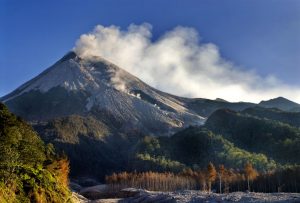
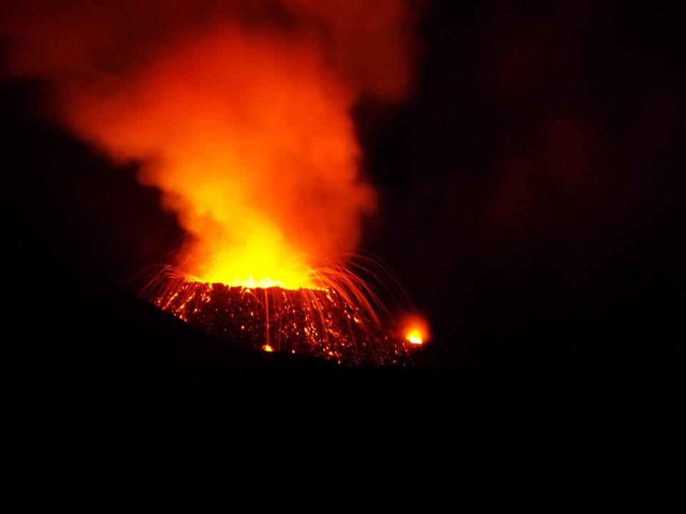
The eruption started on 09/19/2022 around 07:48 local time continues. The amplitude of the eruptive tremor (indicator of surface lava emission) continues to increase since September 29, 9:40 p.m. local time yesterday (5:40 p.m. UTC; Figure 1). This intensification is most certainly linked to an increase in pressure within the eruptive cone causing an increase in activity at the level of the eruptive vent observed for more than 48 hours (Figure 2).
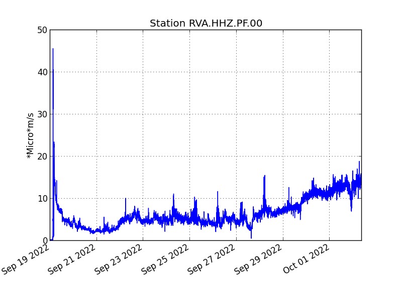
Evolution of the RSAM (indicator of a surface lava emission) since 09/19/2022 00:00 UTC time (04:00 local time) on the RVA seismological station located at the Rivals crater (© OVPF / IPGP).
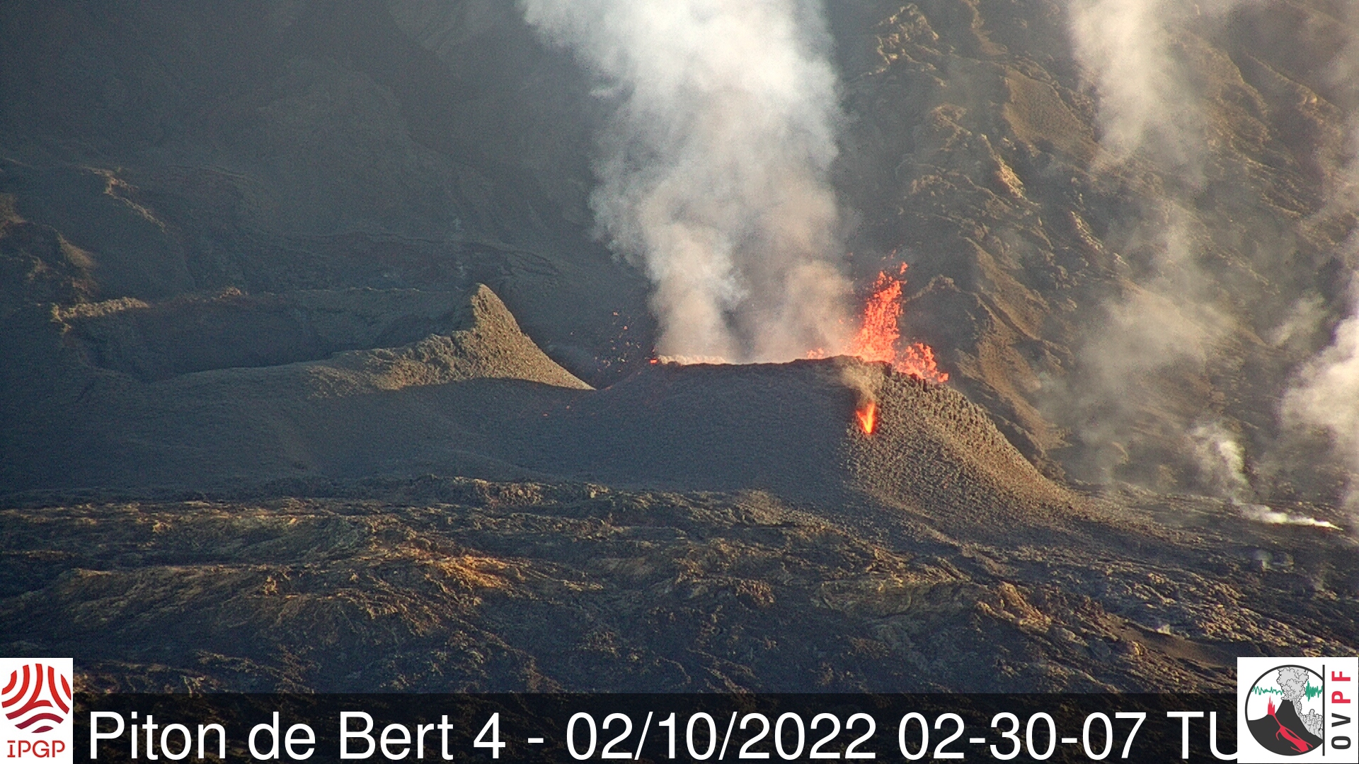
Images from the OVPF-IPGP webcam located at Piton de Bert show:
– still significant lava projection activity at the eruptive vent;
– the secondary vent, located on the southern flank of the cone, is active again (Figure 2);
– degassing is still observed at the eruptive site (Figure 2);
– the majority of lava flows are still through lava tunnels within which numerous resurgences are visible, particularly near the eruptive cone (Figure 2).
The lava flow estimates established by satellite method on the HOTVOLC (OPGC – Clermont Auvergne University) and MIROVA (University of Turin) platforms indicate an average flow over the last 24 hours of 5 to 15 m3/s. Estimated lava flows have been increasing since the tremor intensification observed on September 29. As lava flow activity now takes place primarily in tunnels, these estimates are minimum values.
The acquisitions of the COPERNICUS program developed by the European Commission provide images of the TROPOMI instrument intended for the observation of the composition of the atmosphere, and in particular the concentrations of SO2.
The image of October 1 (09:44 UTC; Figure 3) indicates a notable increase in degassing, with a plume more concentrated in SO2 than the previous days, and visible up to a distance of about 400 km.
Below is the evolution of the integrated mass within a radius of 300 km for the last few days (7 km altitude):
2022-09-26 / 0.3 kton
2022-09-27 / 0.6 kton
2022-09-28 / 0.6 kton
2022-09-29 / 0.8 kton
2022-09-30 / 0.8 kton
2022-10-01 / 1.5 kton
The direction of transport of the plume is always compatible with an altitude of about 3 km. At this altitude and in the hours preceding the acquisition, the wind speed was about 7 m/s (approx. 25 km/h). Thus, the plume visible over a distance of 300 km, with a mass of 1.5 kton, corresponds to an integrated emission over approximately 12 hours, which leads to an estimate of the average flux of SO2 of approximately 3.0 kton/day over these last 12 hours. The true altitude of the plume, less than 7 km, implies that this value is an underestimate (perhaps by a factor of 2 to 5). (©ESA-Copernicus (TROPOMI); GVO (volcanoes); AERIS/ICARE-LOA (VolcPlume portal); INERIE-LCSQA-ATMO France / GEOD’AIR; IPGP).

SO2 concentration detected by the TROPOMI instrument (Copernicus – ESA), October 1, 2022, 9:45 UTC. The unit is the Dobson Unit (surface concentration: 1 DU = 2.69 × 10^16 molecules cm−2 ). (©ESA-Copernicus (TROPOMI), GVO (volcanoes), AERIS/ICARE-LOA (VolcPlume portal)).
Figure 4 shows a zoom on the 1st Capella radar image of the eruption acquired on October 1, 2022, around 18:15 UTC (acquisition in Spotlight mode, with a ground resolution of 60 cm; angle of incidence of 39°; radar acquisition in ascending track, with a sight on the left on a quasi-polar orbit (97°)). The scene is observed from the East Northeast. The black traces that start from the base of the cone and extend towards the southeast are the active (incandescent) flows, which reflect little energy towards the radar.

Zoom on the eruptive cone (on the left the Piton Kalla Pélé, eruption of August-October 2015; on the right the cone under construction since September 19, 2022) from the 1st Capella radar image of the eruption acquired on October 1, 2022, around 6:15 p.m. UTC (acquisition in Spotlight mode, with a ground resolution of 60 cm; angle of incidence of 39°; ascending track radar acquisition, with a view to the left in a quasi-polar orbit (97 °)). The scene is observed from the East Northeast. (©2022, Capella Space, all rights reserved).
– 24 volcano-tectonic earthquakes were recorded directly above the summit area during the day of October 1st.
– The data from the permanent GNSS stations of the OVPF-IPGP no longer show signals associated with a significant deformation of the building.
Alert level: Alert 2-1 (Access to the Enclos prohibited; eruption in the Enclos without any particular threat to the safety of persons, property or the environment)
Source et photos : Direction OVPF / IPGP.
Read the article : http://www.ipgp.fr/sites/default/files/ovpf_20221002_14h00_communique_eruption.pdf
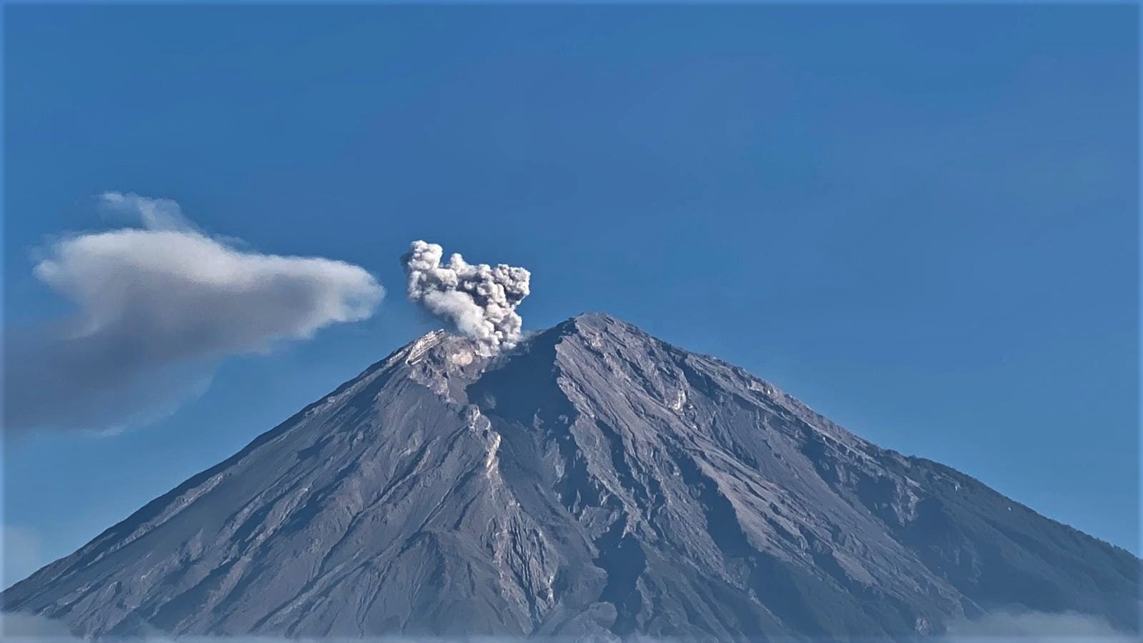
Ecuador , Sangay / Reventador :
DAILY REPORT OF THE STATE OF SANGAY VOLCANO, Sunday October 02, 2022.
Information Geophysical Institute – EPN.
Surface Activity Level: High, Surface Trend: No change
Internal activity level: High, Internal trend: No change.
Seismicity: From October 01, 2022, 11:00 a.m. to October 02, 2022, 11:00 a.m.:
There was no interruption in the transmission of data from the reference station for seismic statistics.
Explosions (EXP) 998
Emission Tremors (TREMI ) 94.
Rains / Lahars:
Rains were recorded in the area. No mudslide occurrence reports were received. **In the event of heavy rains, these could remobilize the accumulated materials, generating mudslides and debris that would descend on the flanks of the volcano and flow into the adjacent rivers.**
Emission / ash column:
The Washington VAAC reported an ash emission with a height of 1170 in a westerly direction. No ash fall report was received.
Gas:
The Mounts satellite system reported 902.7 tonnes of sulfur dioxide (SO2) for yesterday at 6:14 p.m. UTC.
Observation:
Most of the time the area is cloudy.
Alert level: Orange.
——————————————————————————————————————————————–
DAILY REPORT OF THE STATE OF THE REVENTADOR VOLCANO, Sunday October 02, 2022.
Information Geophysical Institute – EPN.
Surface activity level: Moderate, Surface trend: Increasing.
Internal activity level: Moderate, Internal trend: No change.
Seismicity: From October 01, 2022, 11:00 a.m. to October 02, 2022, 11:00 a.m.:
There was no interruption in the transmission of data from the reference station for seismic statistics.
Explosion (EXP): 24
Long Periods (LP): 57
Emission Tremors (TREMI ): 5.
Rains / Lahars:
Light rain was recorded in the area. No lahar reports were received.
Emission / ash column:
In the morning, 2 gas and ash emissions were observed with a westerly direction, both at a height of 900 meters above crater level. In addition, the Washington VAAC reported 4 alerts for ash emissions with a maximum height of 988 meters. The directions that the emissions took went from the North-West to the West.
Gas:
The Mounts satellite system reported 0.1 tonnes of sulfur dioxide (SO2) for yesterday at 6:19 p.m. UTC.
Observation:
At night, incandescence was observed in the crater, as well as an active lava flow was observed through the Rebeca station camera. In the morning, gas and ash emissions were observed, at the moment the sector is totally cloudy.
Alert level: Orange.
Source : IGEPN.
Photos : Juan Guapa , Henry Vasconez.
Chile , Laguna del Maule :
Special Report on Volcanic Activity (REAV), Del Maule region, Laguna del Maule volcanic complex, October 02, 2022, 08:00 a.m. local time (mainland Chile).
The National Service of Geology and Mines of Chile (Sernageomin) publishes the following PRELIMINARY information, obtained through the monitoring equipment of the National Volcanic Monitoring Network (RNVV), processed and analyzed at the Volcanological Observatory of the Southern Andes ( Ovdas):
Since yesterday, October 01, 2022, at 22:06 local time (01:06 UTC, Oct. 02), monitoring stations installed near the Laguna del Maule volcanic complex have recorded a swarm of earthquakes which, at the time of writing this report, counted 330 events associated with rock fracturing (volcano-tectonic type), located 7.1 km south – south-west of the crater.
The characteristics of earthquakes after their analysis are as follows:
ORIGINAL TIME: 22:06 local time (01:06 UTC, 02 Oct.)
LATITUDE: 36.115°S
LONGITUDE: 70.549°W
DEPTH: 2.9 km
LOCAL MAGNITUDE: 0.2 Ml
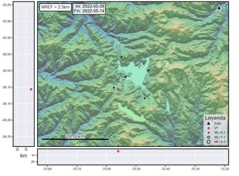
COMMENTS:
The maximum frequency of the seismic swarm occurred between 01:06 and 02:07 UTC. The low energy of this event was noted. At the time of this report, the activity has not ceased but there has been a significant decrease in seismic activity.
The volcanic technical alert remains at the Green level.
Sources : Sernageomin.
Photos : Franco Vera , Sernageomin.
Indonesia , Semeru :
VOLCANO OBSERVATORY NOTICE FOR AVIATION – VONA
Issued : October 02 , 2022
Volcano : Semeru (263300)
Current Aviation Colour Code : ORANGE
Previous Aviation Colour Code : orange
Source : Semeru Volcano Observatory
Notice Number : 2022SMR217
Volcano Location : S 08 deg 06 min 29 sec E 112 deg 55 min 12 sec
Area : East java, Indonesia
Summit Elevation : 11763 FT (3676 M)
Volcanic Activity Summary :
Eruption with volcanic ash cloud at 00h26 UTC (07h26 local)
Volcanic Cloud Height :
Best estimate of ash-cloud top is around 14003 FT (4376 M) above sea level, may be higher than what can be observed clearly. Source of height data: ground observer.
Other Volcanic Cloud Information :
Ash-cloud moving to southwest.
OBSERVATION OF SEISMICITY:
13 eruption earthquakes/explosions with an amplitude of 12-22 mm and a duration of 40-100 seconds.
1 emission earthquake with an amplitude of 5 mm and a duration of 40 seconds.
1 distant tectonic earthquake with an amplitude of 26 mm, S-P 31 seconds and a duration of 71 seconds.
1 lahar signal with an amplitude of 10 mm and a duration of 900 seconds.
Source : Magma Indonésie.
Photo : Andi Volcanist.
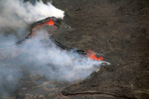
Hawaii , Kilauea :
19°25’16 » N 155°17’13 » W,
Summit Elevation 4091 ft (1247 m)
Current Volcano Alert Level: WATCH
Current Aviation Color Code: ORANGE
Activity Summary:
The summit eruption of Kīlauea Volcano, within Halemaʻumaʻu crater, continued over the past 24 hours. All recent eruptive activity has been confined to the crater. No significant changes have been observed at the summit or in either rift zone.
Halemaʻumaʻu Lava Lake Observations:
Eruption of lava from the western vent into the active lava lake and onto the crater floor continued over the past 24 hours. The active part of the lava lake has stayed steady over the past 24 hours. Overflight measurements from September 12, 2022, indicated that the crater floor had seen a total rise of about 143 meters (469 feet), since the beginning of this eruption on September 29, 2021.
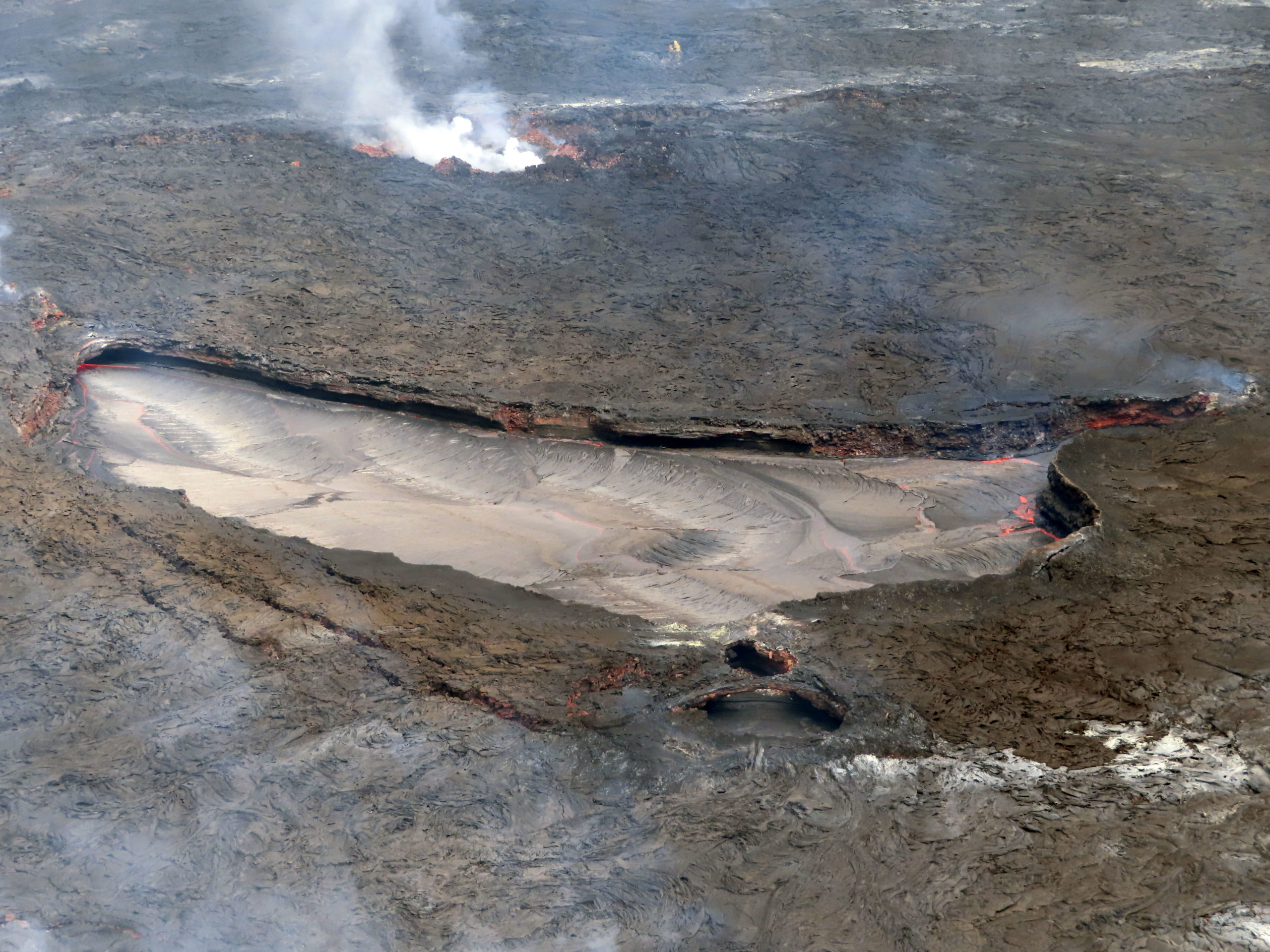
Following a slight drop in the lava lake and subsidence of the crater floor on September 20, at the summit of Kīlauea, the lava lake level has remained several meters (above ten feet) below its rim.
Summit Observations:
Summit tiltmeters have recorded minor inflation over the past 24 hours. Volcanic tremor remains above background levels. A sulfur dioxide (SO2) emission rate of approximately 1,800 tonnes per day (t/d) was measured on September 30, 2022.
Rift Zone Observations:
No unusual activity has been noted along the East Rift Zone or Southwest Rift Zone; low rates of ground deformation and seismicity continue along both. Measurements from continuous gas monitoring stations downwind of Puʻuʻōʻō in the middle East Rift Zone remain below detection limits for SO2, indicating that SO2 emissions from Puʻuʻōʻō are negligible.
Source : HVO.
Photo : USGS / M. Patrick .