September 25 , 2022.
La Réunion , Piton de la Fournaise :
Press release, Paris Institute of Earth Physics, Piton de la Fournaise Volcanological Observatory, September 24, 2022 – 4:30 p.m. (local time) – 12:30 p.m. (UTC time).
Ongoing eruption
The eruption started on 09/19/2022 around 07:48 local time continues. The amplitude of the eruptive tremor (indicator of surface lava emission) has remained broadly stable over the past 24 hours, at about 20% of its initial amplitude.
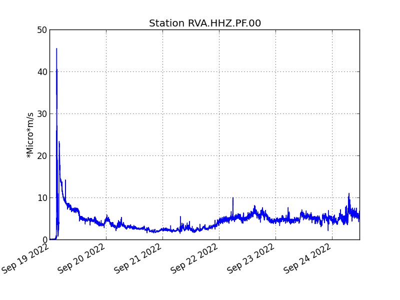
Evolution of the RSAM (indicator of a surface lava emission) since 09/19/2022 00:00 UTC time (04:00 local time) on the RVA seismological station located at the Rivals crater (© OVPF / IPGP).
– No volcano-tectonic earthquake has been recorded directly above the summit area over the past 24 hours.
– Following the rapid deformations of the ground on September 19 linked to the injection of magma towards the surface which showed a multi-decimetric displacement on the south-west flank of approximately 45-50 cm max., a deflation of the summit zone has followed the first 3 days of the eruption. This deflation was linked to the emptying of the reservoir located under the summit to supply the eruptive site. For the past two days, GPS data have shown a relative stabilization of surface deformations.
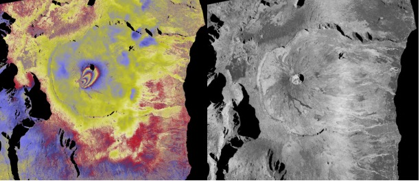
(Left) Interferogram showing the displacements produced by the current eruption. ALOS2 interferogram (Band L) in Spotlight mode (SPT_159 Ascending Left Look Angle ~58°) covering the period between 08/23/2022 and 09/20/2022. The interferogram shows a displacement on the southwest flank of the summit cone with ~4 fringes, i.e. ~45-50 cm of displacement from the ground towards the satellite. (Right) coherence map covering the same period (©ISDeform; OSUG-EOST-OSUL-IPGP-OPGC).
Thanks to clear skies since this morning on the Piton de la Fournaise, lava flow estimates have been established by satellite method on the HOTVOLC (OPGC – Clermont Auvergne University) and MIROVA (University of Turin) platforms. These estimates indicate a relatively stable average flow over the last 24 hours of between 1 and 3.5 m3/s.
These flows are in line with the flows estimated from the sulfur dioxide (SO2) flow data in the atmosphere recorded by the NOVAC stations of the OVPF-IPGP located on the edge of the Enclosure. These data suggest an average flow of around 1.5 m3/s over the past few days.
Flow estimates indicate a total emitted volume of around 1.2 to 2.5 million m3 since the start of the eruption. This value must be considered as a minimum estimate due to the bad weather conditions in recent days which have attenuated the thermal radiation during the lava effusion peaks and which have disturbed the flow acquisitions of
SO2 in the atmosphere.
SO2 monitoring is also done via the acquisitions of the COPERNICUS program developed by the European Commission, which provides images from the TROPOMI instrument intended for observing the composition of the atmosphere. Images from September 23 (Figure 3) indicate a weak gas plume trending west-southwest. The mass of SO2 visible in the image
remains below 1 kton. It should be noted that for the day of September 23, the acquisition was highly noisy by the presence of clouds inducing an underestimation of the mass of SO2.
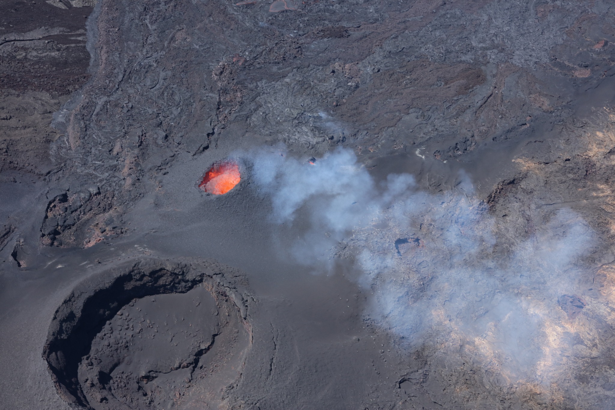
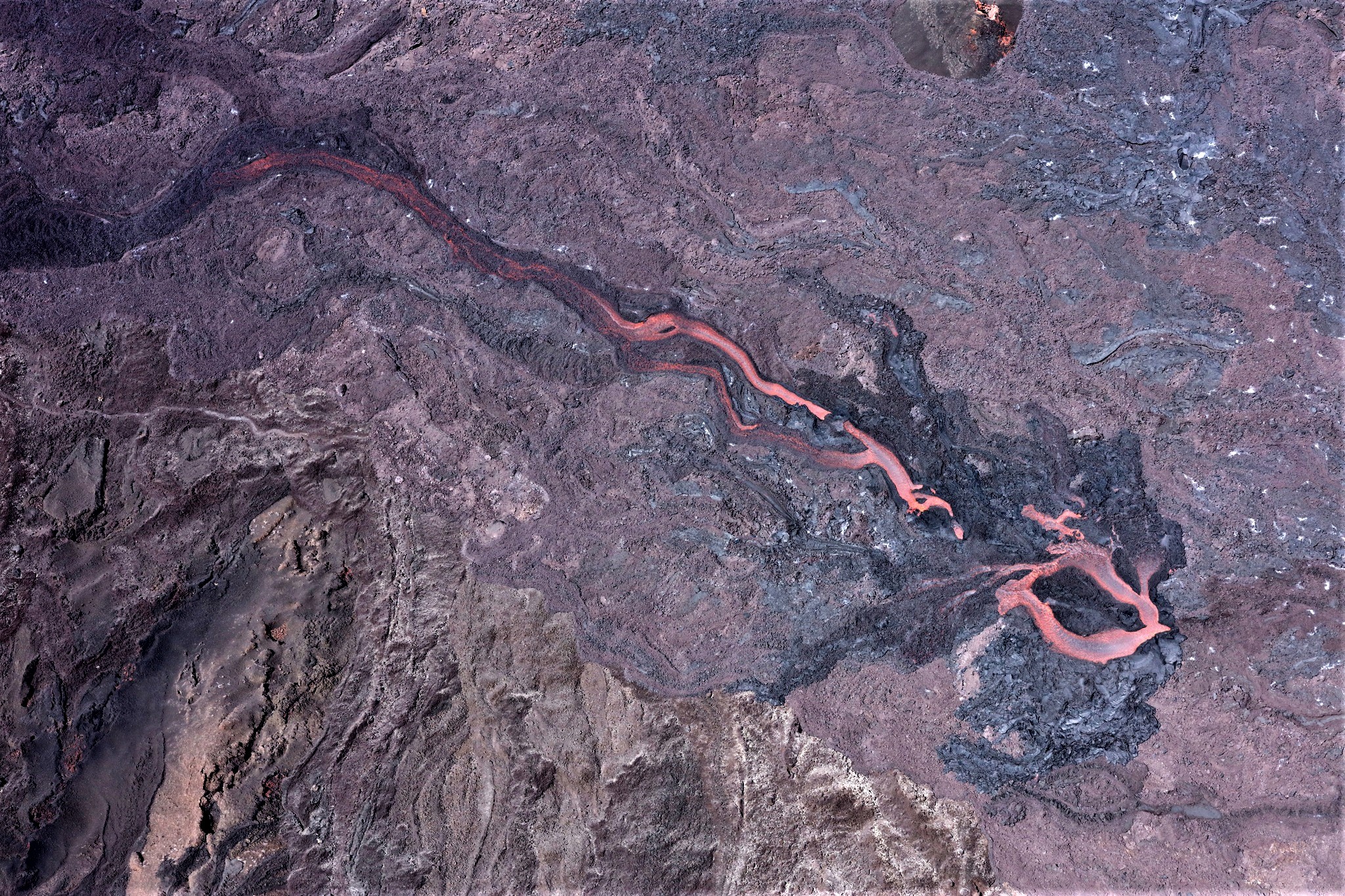
The images from the OVPF-IPGP webcam located at Piton de Bert, as well as the images of the ULM overflight of the eruptive site by a team from the OVPF-IPGP this morning, show:
– significant degassing at the eruptive site and low amplitude lava projections;
– a gas plume still directed west southwest as is also visible on satellite data;
– lava flow activity occurring mainly through lava tunnels, with two flow axes: one to the east and the other to the southeast;
– several resurgences of lava are visible at the level of the tunnels;
The active lava front was located this morning in the sector of the Château Fort crater around 2000 m altitude.
Alert level: Alert 2-1 (eruption in the Enclos without any particular threat to the safety of people, property or the environment).
Source et photos : Direction OVPF / IPGP.
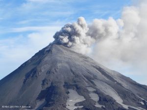
Italy , Stromboli :
Press release on the activity of STROMBOLI, September 25, 2022, 06:19 (04:19 UTC).
The National Institute of Geophysics and Volcanology, Osservatorio Etneo, reports that monitoring networks recorded at 06:06 (04:06 UTC), that from about 02:10 UTC, an intensification of activity explosive from the North Crater area, with some stronger explosions like the one recorded at 02:29 UTC. The material produced falls abundantly in the upper part of the Sciara del Fuoco, rolling along the slope. In conjunction with the increase in explosive activity, from 02:30 UTC, a modest overflow of lava is observed from the area of the North crater which is located in the upper part of the Sciara del Fuoco.
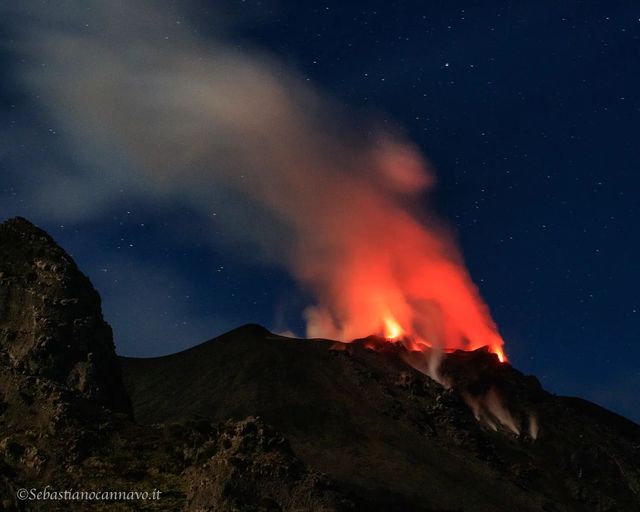
In correspondence with the explosion at 02:29 UTC, a seismic signal lasting about 3 minutes is detected.
Soil deformation monitoring networks show no significant variations.
Further updates will be communicated soon.
Source : INGV.
Photo : Sebastiano Cannavo / Stromboli Stati d’animo.
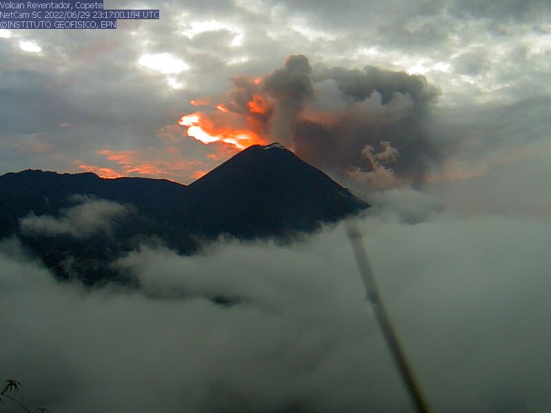
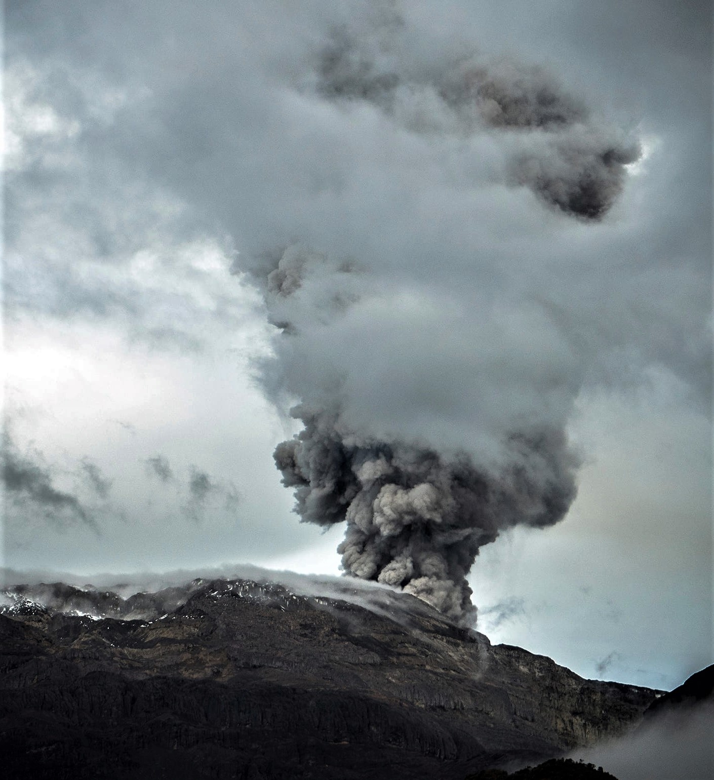
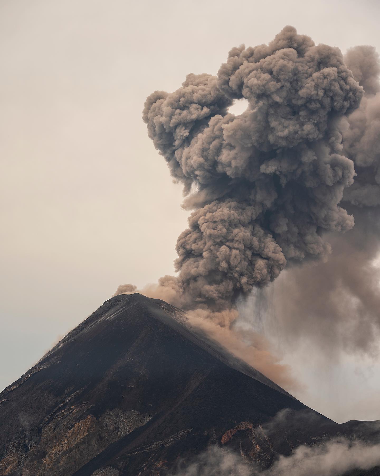
Ecuador , Sangay / Reventador :
DAILY REPORT OF THE STATE OF SANGAY VOLCANO, Saturday September 24, 2022.
Information Geophysical Institute – EPN.
Surface Activity Level: High, Surface Trend: No change.
Internal activity level: High, Internal trend: No change.
Seismicity: From September 23, 2022, 11:00 a.m. to September 24, 2022, 11:00 a.m.:
Explosion (EXP) 750
Long Periods (LP) 25
Emission Tremors (TREMI ) 60.

Rains / Lahars:
The Windy app recorded light rain in the area, which did not generate signals associated with diminishing mudslides and debris flows. **In the event of heavy rains, these could remobilize the accumulated materials, generating mudslides and debris that would descend on the flanks of the volcano and flow into the adjacent rivers.**
Emission / ash column:
During the afternoon of yesterday, several emissions of gas and ash were observed at about 2000 meters above the level of the crater in a South-West direction. The Washington VAAC issued 4 reports of ash emissions whose heights reached 1,170 meters above the level of the crater, with directions to the west and southwest.
Other Monitoring Parameters:
The FIRMS system recorded 3 thermal alerts and the MIROVA system recorded 1 moderate thermal alert in the last 24 hours.
Observation:
The volcano area was largely cleared yesterday afternoon, observing the emissions described above. During the morning today, the area remained completely cloudy
Alert level: Orange.
——————————————————————————————————————————————–
DAILY REPORT OF THE STATE OF THE REVENTADOR VOLCANO, Saturday September 24, 2022.
Information Geophysical Institute – EPN.
Surface Activity Level: Moderate, Surface Trend: No change.
Internal activity level: Moderate, Internal trend: No change.
Seismicity: From September 23, 2022, 11:00 a.m. to September 24, 2022, 11:00 a.m.:
The REVS reference station for daily seismic statistics transmitted smoothly for the past 24 hours.
Explosion (EXP): 44
Long periods (LP): 31
Emission Tremors (TREMI): 14.
Harmonic Tremors (TRARM): 3.
Rains / Lahars:
No rain was recorded in the area.
Emission / ash column:
Emissions of gas and ash were observed reaching heights of up to 1000 meters above the level of the crater in a west and northwest direction. The Washington VAAC reported 4 ash emissions with heights up to 1338 meters above crater level in a northwesterly direction.
Other Monitoring Parameters:
The FIRMS system recorded 2 thermal anomalies and the MIROVA system recorded 1 moderate thermal alert in the last 24 hours.
Observation:
The sector of the volcano remained clear from yesterday afternoon until the beginning of the morning of today, making it possible to identify the emissions previously described. At night and early in the morning, an incandescence was observed in the crater. The lava flow on the northeast flank remains active
Alert level: Orange.
Source : IGEPN.
Photos : volcan sangay FDB / Lucas Scott , Martin Rietze ( archive).
Colombia , Nevado del Ruiz :
Bulletin of activity level of the Nevado del Ruiz volcano.
The activity level continues at the Yellow Activity Level or (III): changes in the behavior of volcanic activity.
Regarding the monitoring of the activity of the Nevado del Ruiz volcano, the COLOMBIAN GEOLOGICAL SERVICE reports that:
Seismicity related to fluid dynamics inside volcanic conduits showed a slight increase in the number of recorded earthquakes and released seismic energy, compared to the previous week. According to cameras installed in the volcano area, according to the report of Los Nevados National Natural Park officials and SGC staff, gas and ash emissions associated with some of these seismic signals have been confirmed in the area. Likewise, changes in the relative temperature of the material observed in the gas and ash columns were observed.
The seismicity associated with the fracturing maintained similar levels in the number of earthquakes recorded and in the seismic energy released, compared to the previous week. The earthquakes were located in the East-South-East, South-West, North-East sectors and in the Arenas crater. The depth of the earthquakes varied between 0.2 and 6.8 km. The maximum magnitude recorded during the week was 1.7 ML (Local Magnitude), corresponding to the earthquake of September 17 at 00:12 (local time), located 7.0 km east-southeast of the Arenas crater at a depth of 4.5 km.
Deformation of the volcanic surface continues to show minor changes.
Source : SGC.
Photo : Álex Palacio.
Guatemala , Fuego :
Activity:
The Fuego Volcano Observatory OVFGO reports 6 to 12 weak, moderate and a few strong explosions that expel columns of ash from a height of 4,700 to 4,800 meters above sea level (15,420 to 15,748 feet ) which disperses in a west-northwest direction over distances of 15 kilometres. Low, moderate and loud rumblings were reported which generate low to moderate shock waves causing vibrations in the roofs and windows of houses near the volcano. Following these explosions, avalanches of weak, moderate and strong characteristics are generated on the contour of the crater, as well as in the ravines Ceniza, Santa Teresa, Las Lajas, Honda, part of the material reaching the edge of the vegetation.
At night incandescent pulses were also observed 200 meters above the crater. Sounds similar to those of a train locomotive lasting 1 to 3 minutes are reported. Due to the direction of the wind, there is a probability of ash fall in the communities of Panimache I and II, Morelia, Finca la Asunción, Santa Sofía, El Porvenir, Finca Palo Verde, Yepocapa, Sangre de Cristo and others in a west-northwest direction.
Source : Insivumeh.
Photo : Diego Rizzo / @diegorizzophoto .