September 15 , 2022.
La Palma , Cumbre Vieja :
ACTIVITY AT LA PALMA.- NOISES, TREMORS, SHOCKS AND A LOT OF GAS.- THE VOLCANO IS REACTIVATING.
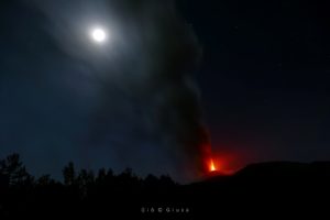
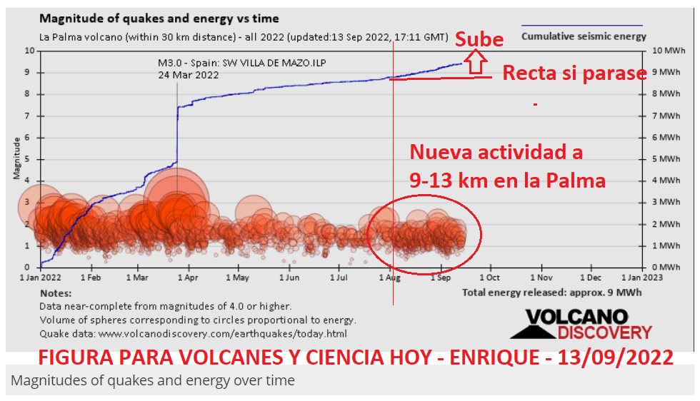
The volcano has been undergoing a new process for a month, which is a slight reactivation in the rules, but without fear of error, it is a reactivation. In the depth chart for 2022, the sustained increase in activity at 9-13 km is clearly visible causing magma to migrate through this area.
In recent days, especially in the last few hours, in addition to the unbreathable bluish SO2 gases throughout the Aridane Valley, people feel like stones and blows are rolling, as well as vibrations and tremors in various areas of Los LLanos, Las Manchas and El Mazo, with the opening of new cracks in some cases. Some even describe it as a veritable « underground storm ». Indeed, some have heard « jets » or jets of pressurized gas due to strong emissions from fumaroles which have resulted in some ashes in the surroundings.
A new crack has been located a little further south, which, if it opens, will affect the areas between El Remo and Puerto Naos, from which many gases are coming out. This crack could be a gas chimney and the point that has the most probability in case the magma rises, which incidentally is just below, pushing in a swarm that forces it to move southwest from the Cumbre Vieja reservoir towards EL Remo.
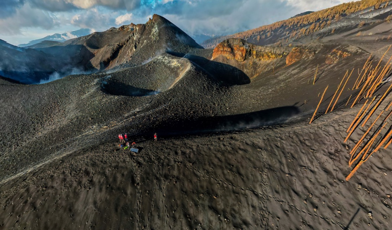
The graph of earthquakes with depth shows that the area between 9 and 13 km is more active, which is reflected in the greater number of earthquakes in recent days and which is starting to be clearly visible in the graph of the depth. accumulated released seismic energy (blue line). It has a continuous release of energy that tells us that a process has been going on for almost a month.
How is the state of the volcanic system changing? For the moment it is NOT going towards an eruption in a clear way, it is a process which is maintained, which makes its way, but which does not stop. The good news is that it does not accelerate more (more seismicity), but it does not slow down either, so we are waiting to see. (Henrique)
Source : Volcanes y Ciencia Hoy.
Photos : Volcanes y Ciencia Hoy , I love the World .
Colombia , Purace / Los Coconucos Volcanic Range :
Weekly bulletin of the activity of the Puracé volcano – Los Coconucos volcanic chain
The activity level of the volcano continues at the Yellow activity level or (III): changes in the behavior of volcanic activity.
From the analysis and evaluation of the information obtained through the monitoring network of the Puracé volcano – Los Coconucos volcanic chain, during the week of September 6 to 12, 2022, the COLOMBIAN GEOLOGICAL SERVICE – Volcanological and Seismological Observatory of Popayan reports that:
During the period evaluated, 873 seismic events were recorded, of which 116 were associated with rock fracturing processes (type VT) and 757 with fluid dynamics in volcanic conduits; Of these, 620 were classified as long-period type events (LP type), 28 were associated with both failure mechanisms and fluid dynamics, for which they were classified as hybrids (HB type), three (3) were classified as « Tornillos » type earthquakes (TO type) and 102 as low energy tremor pulses (TR type).
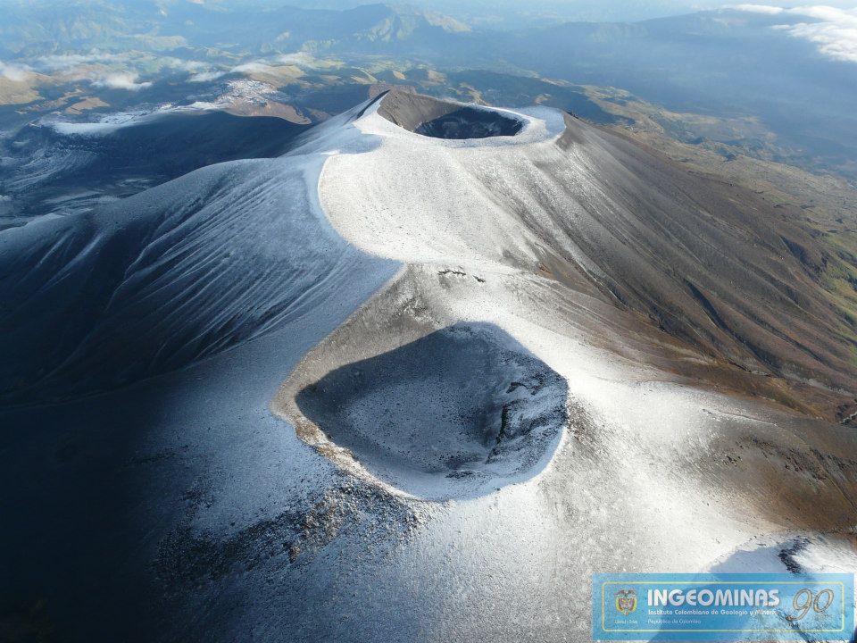
The geodetic network of GNSS (Global Navigation Satellite System) stations for monitoring ground deformation continues to record a process associated with inflation.
In the monitoring of surface activity, the images obtained during the week thanks to the Anambío, Mina, Lavas Rojas, Cerro Sombrero and Curiquinga web cameras showed degassing of the volcanic system, with a white column oriented preferentially towards the North -West.
Regarding volcanic gas monitoring, sulfur dioxide (SO2) flux emissions recorded by telemetric stations continue to show changes in the flux, with a maximum emitted of 5714 t / day for the week assessed. The other instruments for measuring carbon dioxide (CO2) and radon gas (222Rn) in the volcanic influence zone record considerable variations in their concentrations for the period evaluated, which is normal in active volcanic systems.
Magnetic field and infrasonic wave monitoring sensors did not record variations associated with changes in volcanic activity.
Based on the above, it is concluded that significant variations in volcanic activity continue to be recorded, in accordance with the behavior expected at activity level III (yellow level), which could evolve towards activity states more important.
Source et photo : Ingeominas.
Indonesia , Gamalama :
Press release on the volcanic activity of Mount Gamalama, September 14, 2022.
Volcanic activity at Mount Gamalama has fluctuated since January 2022, with seismicity dominated by distant tectonic earthquakes and local tectonic earthquakes. The current level of activity has been at level II (WASPADA) since March 10, 2015. The last eruption occurred on October 4, 2018 with an ash column height of 250 meters from the summit.
The latest developments on Mount Gamalama activities through September 14, 2022 at 06:00 WIB are as follows:
There was an increase in deep volcanic earthquakes on September 14, 2022. From 00:00 to 06:00 WIB, 9 VA earthquakes were recorded with a maximum amplitude of 2-3 mm and a duration of 8-14 seconds.
In general, seismic data through September 14, 2022 at 24:00 WIB tends to fluctuate and is still dominated by distant tectonic earthquakes and local tectonic earthquakes related to regional tectonic activity around the Halmahera Islands.
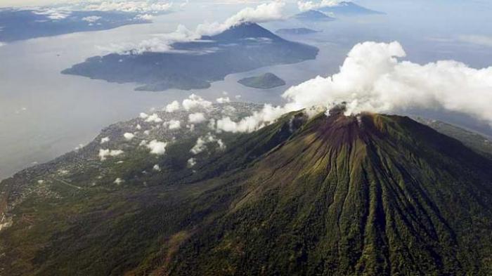
Visually, the smoke from the crater is white/brown with low, medium to thick intensity, approximately 5 to 250 meters above the summit.
Under the above conditions, and given the characteristics of the precursor to the G. Gamalama eruption, the potential hazard most likely to occur is a phreatic eruption with the threat of danger presently in the form of an ejection of material from the main crater hitting the area with a radius of 1.5. km from the center of the eruption. Fine ash rain can occur with distance and intensity depending on wind direction and speed.
Based on observations, analysis of visual and instrumental data up to September 14 at 12:00 WIB, Mount Gamalama’s activity level is still at Level II (WASPADA).
Source : PVMBG.
Photo : KOMPAS/HERU SRI KUMORO
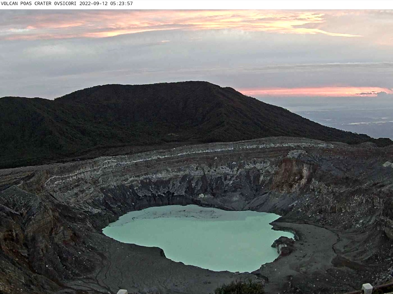
Costa Rica , Poas :
On 9 September OVSICORI-UNA reported that activity at Poás had increased since mid-August, characterized by notably increased seismicity. Seismic signals consisted of tremors with variable amplitudes and durations, prolonged harmonic tremors, and some long-period earthquakes with magnitudes greater than those recorded during 2022; there was no increase in low-frequency earthquakes. The energy of the seismicity had also dramatically increased in the previous few days. Sulfur dioxide emissions around the crater were mainly stable at 100 tons per day, though on a few occasions the concentrations were higher; about 300 tons per day was recorded during 17-18 August and higher than 500 tons per day was recorded on 2 September. The volume of water in Boca A lake had significantly increased during August 2021-September 2022, stabilizing at 1.4 million cubic meters between July and September with minor variations measured from week to week. Convection cells in the lake were more active and a new one formed in the N part of the lake (over the Boca C vent) since mid-August. OVSICORI-UNA stated that these data indicated disturbances to the shallow (less than 2 km) hydrothermal system and did not reflect an influx of magma. Fumarolic degassing and lake convection continued during 9-13 September.
Seismic activity
The increase is mainly manifested by seismic activity, with the appearance of tremors of varying amplitude and duration, manifested by prolonged broad-spectrum tremors (with frequencies between 2 and 8 Hertz), tremors of short duration, both broad-spectrum and monochromatic, and prolonged harmonic tremors. Although there is no increase in low frequency (LP) earthquakes, some LP earthquakes with magnitudes greater than those recorded during this year have been observed. The graph shows the dramatic increase in seismic energy released over the past few days.
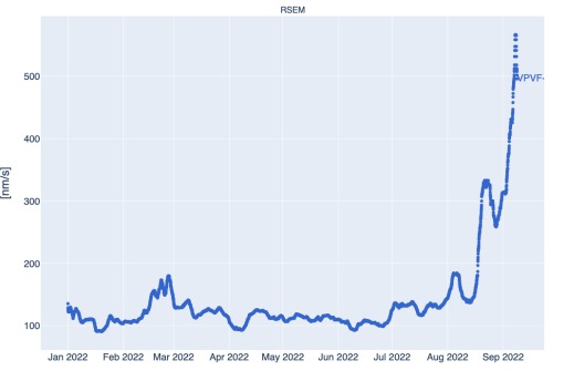
Weekly moving average of the seismic energy released (RSEM), measured at the seismic station closest to the active crater of the Poás volcano since January 1, 2022
Interpretations
To date, there is no evidence that there is a significant contribution of « fresh » magma reaching surface levels as was the case in 2017 when activity evolved from phreatic to phreato-magmatic culminating in Strombolian eruptions. What is detected is the movement of superficial hydrothermal fluids (< 2 km depth) with a small increase in pressure under the crater. No changes were detected on the surface with manifestations such as bubbles, geysers or hydrothermal eruptions. However, the Laguna Caliente convection cells are more active and a new one appeared to the north in mid-August.
The lake is at a level that has not been recorded for 20 years (average depth 41 m), and no phreatic eruption has occurred since September 30, 2019, which increases the risk of a vigorous phreatic eruption. However, this situation was not observed before and leaves significant uncertainty as to the most likely scenario. The rupture of the hydrothermal seal can be gradual or sudden. In the second case, it could represent a significant potential danger for officials and visitors to the belvedere.
Source : GVP , Ovsicori .
Photo : Ovsicori.
Japan , Sakurajima :
JMA reported that nighttime incandescence at Minamidake Crater (at Aira Caldera’s Sakurajima volcano) was visible during 5-12 September. The seismic network recorded four eruptive events and seven explosions. Volcanic plumes rose as high as 2.3 km above the crater rim and ballistics were ejected as far as 1.3 km from the vent. The Alert Level remained at 3 (on a 5-level scale), and residents were warned to stay 2 km away from the crater.
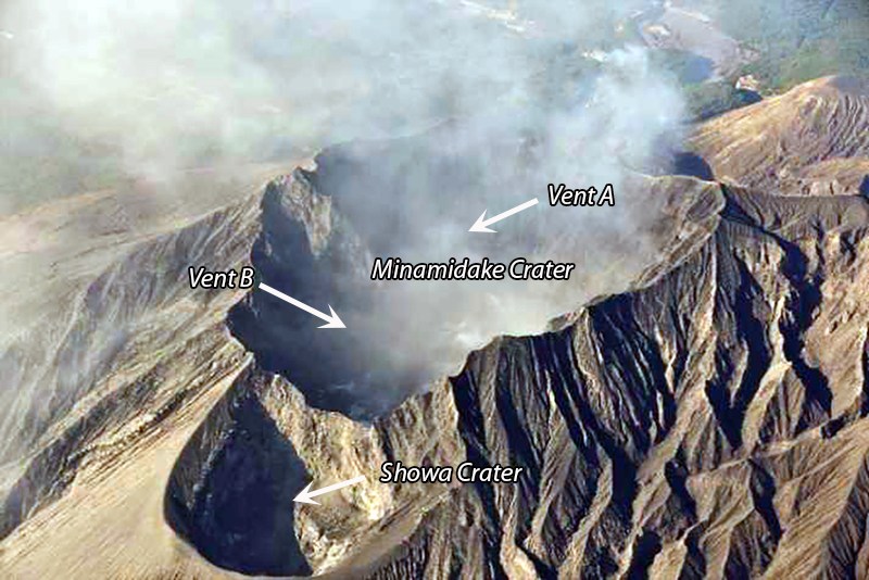
The Aira caldera in the northern half of Kagoshima Bay contains the post-caldera Sakurajima volcano, one of Japan’s most active. Eruption of the voluminous Ito pyroclastic flow accompanied formation of the 17 x 23 km caldera about 22,000 years ago. The smaller Wakamiko caldera was formed during the early Holocene in the NE corner of the Aira caldera, along with several post-caldera cones. The construction of Sakurajima began about 13,000 years ago on the southern rim of Aira caldera and built an island that was finally joined to the Osumi Peninsula during the major explosive and effusive eruption of 1914. Activity at the Kitadake summit cone ended about 4850 years ago, after which eruptions took place at Minamidake. Frequent historical eruptions, recorded since the 8th century, have deposited ash on Kagoshima, one of Kyushu’s largest cities, located across Kagoshima Bay only 8 km from the summit. The largest historical eruption took place during 1471-76.
Sources : JMA , GVP.
Photo : via INGV