September 10 , 2022.
Chile , Nevados de Chillan :
Seismology
The seismological activity of the period was characterized by the recording of:
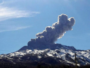
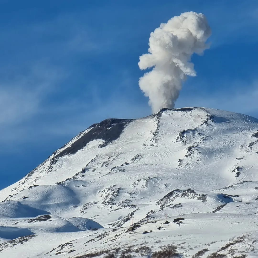
55 volcano-tectonic earthquakes (VT) associated with brittle rupture processes; the most energetic earthquake had a local magnitude (ML) equal to 1.6, whose location was estimated at a depth of 4.5 km and an epicentral distance of 4.3 km in the East-South- East relative to the active crater. Long period (LP), explosion (EX) and tremor (TR) seismicity continued to be recorded, associated with fluid dynamics within the volcanic system. 686 LP-type earthquakes were classified, of which 194 were related to explosions at surface level, due to the presence of acoustic waves and/or gaseous emissions, specifying that the recording of the two characteristics mentioned is difficult due to adverse weather conditions, which may result in a decrease from the ideal count for this type of event. The size of the largest LP earthquake estimated from the Reduced Displacement (DR) parameter reached a value equal to 422 cm2 at the PTZ station, linked to the occurrence of an energetic explosion with surface expression, which generated an acoustic wave with a maximum pressure of 166 Pa (pressure estimated at 1 km from the source), and generated a column close to 2 km, in turn causing surface morphological changes at the level of the active crater (see more details in the paragraph « Satellite geomorphological analysis »). After this explosive episode, a decrease in the daily LP and TR energies is recorded, a trend that is observed because it accounts for the superficial internal dynamic changes related to a large instantaneous release of energy in various forms.
Regarding TR type seismicity, 227 episodes were identified, the most important of which reached a DR of 114 cm2 accompanied by an acoustic wave associated with a maximum pressure difference of 0.14 Pa at 1 km.
Fluid Geochemistry
Data on sulfur dioxide (SO2) emissions obtained by optical differential absorption spectroscopy (DOAS) equipment, corresponding to the Philippi and Chillán stations, installed 1.5 km to the South-South-East (SSE) and 2.7 km east-southeast (ESE) of the active crater, respectively, showed an average value of 413 ± 69 t/d, with a maximum daily value of 769 t/d, recorded on 26 august. A slight decrease in SO2 emission rates is observed.
Satellite thermal anomalies
Four thermal alerts were recorded in the area associated with the volcanic complex during the period, with a maximum Volcanic Radiative Power (VRP) of 2 MW on August 30, a value considered low according to data processed by MIROVA. An increase in the power of these anomalies is observed during the reported period, with a total radiant surface estimated at 3,600 m2, subject to the active crater.
At the same time, according to the analytical processing of satellite images (Sentinel 2-L2A in combination of false color bands), luminance anomalies were observed on August 18, 21, 26, 28 and 31.
Geodesy
According to the data provided by the geodetic monitoring network (GNSS and inclinometers), the most important aspects related to volcanic deformation have been characterized by:
– A slight decrease in the rate of vertical movement; This decrease in the rate can be observed in the vertical components of the GNSS stations, returning to their average deformation rate of the last 8 months, after the change observed the previous month. The adjustment for this month reaches a maximum rate of -0.79 cm/month in the stations closest to the source of deformation (western sector of the active crater).
– Minimal variations of the horizontal components (surveillance lines), testifying to a subsidence of the volcanic system and which also present a displacement rate of very low amplitude and lower than the previous month.
– Minimal variations of electronic inclinometers, attributable to changes in the operating temperature of the equipment, with inclinations reaching approximately 5 micro radians.
The geodetic data suggest the action of a source of surface deformation, and there is no indication of deep processes related to new material intrusion processes.

Satellite geomorphological analysis
From geomorphological observations made on Planet Scope and Sentinel 2 L2A satellite images, the growth of Dome 4 within the active crater has been identified, as well as changes in topographic data related to the mechanical entrainment of material towards the northern rim. -east of the crater. The thermal radiance anomaly seen in Sentinel 2 L2A false-color images coincides with the location of the exposed portion of Dome 4. Photo-interpretation of a SkySat Collect image from August 19 identified crack development from East / West and North South oriented feeding, tension cracks and a bulge in the North-Northeast part of the active crater, which was observed from surveillance cameras and their growth recorded. In addition, a channel was observed connecting the bulge to the northeast with the exposed part of the dome in the southern part of the crater, which presents a thermal radiation anomaly.
It is interpreted that the morphological changes identified from both satellite images and surveillance cameras are the product of the acceleration of the extrusion process of an effusive body.
In turn, a partial collapse of the extruded material was identified towards the end of the month.
Source : Sernageomin
Read the article : https://rnvv.sernageomin.cl/rnvv/TI_Santiago_prod/reportes_LB/2022/RAV_20220908_%C3%91uble_v16.pdf
Photos : Emmanuel Trindade , Explora Turismo .
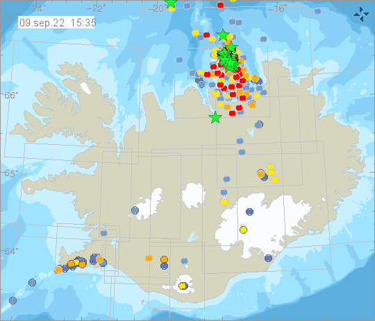
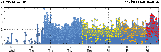
Iceland , Grimsey Islands:
Seismic swarm began on 8th of September, east of Grímsey. A total of 2300 earthquakes have been detected and the largest earthquake detected was a M4.9 on the 8th of September at 04:01.
SEPTEMBER 8, 2022
Magnitude Mw4,9 earthquake east of Grímsey island (Tjörnes Fracture Zone)
During the night of 8-September-2022 at 04:01 UTC an earthquake with magnitude of Mw4,9 took place east of Grímsey island. According to news reports this earthquake did wake up people in Grímsey island and was felt over a wide area in north-eastern Iceland. Over 22 earthquakes with magnitude above Mw3,0 have taken place since this earthquake swarm started. Over 700 earthquakes have been recorded at the writing of this article. This earthquake swarm is ongoing and number of earthquakes and possible stronger earthquakes might happen after this article is published.
Earthquake swarms like this are common in this part of Tjörnes Fracture Zone and happen every 2 to 3 years, it is longer between large earthquakes in the magnitude range of 6,0 to 7,0, but they do happen. This area has an volcano, but there are no signs that is currently active and remains dormant.
Source : Vedur is , icelandgeology.net .
Photos : Vedur is
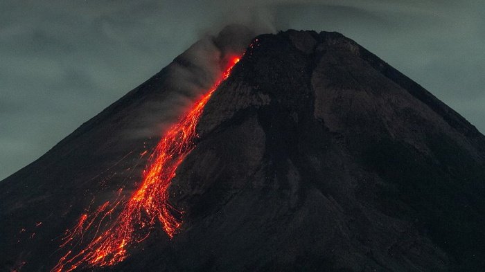
Indonesia , Merapi :
Report on the activity of Mount Merapi from September 02, 2022 to September 08, 2022, Published on September 02, 2022
RESULTS OF OBSERVATIONS
Visual
The weather around Mount Merapi is usually sunny in the morning and afternoon, while the evening is foggy. White smoke, thin to medium thickness, low pressure and 75 m high was observed from the Mount Merapi observation post of Babadan on September 07, 2022 at 12:27 WIB.
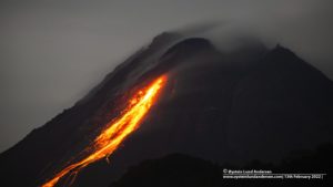
This week, 20 lava avalanches were observed in the Southwest, descending the Bebeng River with a maximum sliding distance of 1700 m.
On the Southwest dome, there is no change in the height of the dome. For the central dome, no significant morphological change was observed. Based on photo analysis, the volume of the dome is still calculated at 1,664,000 m3, and for the central dome it is 2,772,000 m3.
Seismicity
This week, the seismicity of Mount Merapi showed:
528 deep volcanic earthquakes (VTA),
19 shallow volcanic earthquakes (VTB),
239 multi-phase earthquakes (MP),
450 avalanche earthquakes (RF),
76 emission earthquakes (DG),
8 tectonic earthquakes (TT).
The intensity of this week’s seismicity is still quite high.
Deformation
Mount Merapi’s deformation that was monitored using EDM and GPS this week showed a distance shortening rate of 0.2 cm/day.
Rain and lahars:
This week, no rain was reported at the Mount Merapi observation post. There have been no reports of lahars or additional flow in the rivers that originate from Mount Merapi.
Conclusion
Based on the results of visual and instrumental observations, it is concluded that:
The volcanic activity of Mount Merapi is still quite high in the form of effusive eruption activity. The state of the activity is defined at the « SIAGA » level.
Source : BPPTKG.
Photo : ANTARA FOTO/Hendra Nurdiyansyah
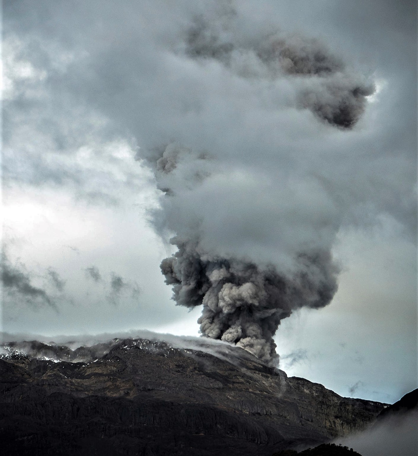
Colombia , Nevado del Ruiz :
Subject: Nevado del Ruiz volcano activity level bulletin.
The activity level continues at the yellow activity level or (III): changes in the behavior of volcanic activity.
Regarding the monitoring of the activity of the Nevado del Ruiz volcano, the COLOMBIAN GEOLOGICAL SERVICE reports that:
Seismicity related to fluid dynamics within volcanic conduits maintained similar levels in the number of recorded earthquakes and released seismic energy, compared to the previous week. An increase in the energy of the continuous volcanic tremor and the duration of some of the signals stands out. In general, the seismic signals associated with this process maintained moderate energy levels and were located in the Arenas crater.
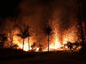
It is important to mention that during the week several confirmation reports of ash fall were received in the municipalities of Villamaría, Manizales and Palestina.
Seismicity associated with rock fracturing showed a decrease in the number of recorded earthquakes and released seismic energy, compared to the previous week. However, this type of seismicity presented moderate levels in the number of earthquakes, as evidenced by the increases recorded on September 1 and 4 in the North-Northwest and South-Southwest sectors of the volcano. In general, the earthquakes were located in the North-North-West, South-West and South-South-East sectors approximately between 2.0 and 4.0 km from the Arenas crater and, to a lesser extent, in the Arenas crater and in the northeast area. The depth of the earthquakes varied between 1.0 and 5.0 km. The maximum magnitude recorded during the week was 2.3 ML (Local Magnitude), corresponding to the September 1 earthquake at 6:44 p.m. (local time), located 2.0 km north-northwest of the Arenas crater at a depth of 5.0 km.
The column of gas and steam reached a height of 1900 meters measured at the top of the volcano on September 2. The dispersion of the column was governed by the direction of the wind, which presented a predominant tendency towards the North-West and the West-North-West of the volcanic edifice.
Source : SGC
Photo : Álex Palacio
La Martinique , Mount Pelée :
Weekly report on the activity of Mount Pelée for the period from September 02, 2022 to September 09, 2022.
Between September 02, 2022 at 4 p.m. (UTC) and September 09, 2022 at 4 p.m. (UTC), the OVSM recorded at least 18 volcano-tectonic earthquakes of magnitude less than 0.1. These low-energy earthquakes could not be located. These are earthquakes identical to those of the well-known families on Pelee which are located inside the volcanic edifice around 0.4 km deep above sea level or about 1 km below the summit. This superficial volcano-tectonic seismicity is associated with the formation of micro-fractures in the volcanic edifice.
During the period of this report, the OVSM also recorded a hybrid-type earthquake with a magnitude of about 0.7 (with characteristics intermediate to those of volcano-tectonic and long-period earthquakes), and an earthquake of the low-magnitude long-period type. These signals containing low frequencies are associated with the presence of fluids (gas, hydrothermal waters) in the volcanic edifice.
None of these earthquakes was felt by the population.

During volcanic reactivation phases, periods of higher seismic activity often alternate with phases of lower seismicity. Since the reactivation of the hydrothermal-magmatic system (end of 2018), the OVSM has not recorded any earthquakes of volcanic origin during the month of May 2019 and less than 3 earthquakes in October 2019 and August 2020. This variability in the number of earthquakes has already, for example been observed following the reactivation of Soufrière de Montserrat.
An extension of two known areas of degraded vegetation located between Morne Plumé and the Chaude River was observed during a helicopter flight carried out on February 9 and May 5, with the support of Dragon 972, and confirmed by image analysis. satellites and drones (overflight of May 11) . A new area of degraded vegetation, located just north of the Chaude River, was observed from August 26th.
The alert level remains YELLOW: vigilance.
Source : OVSM-IPGP.
Photo : cntraveler.com