September 03 , 2022.
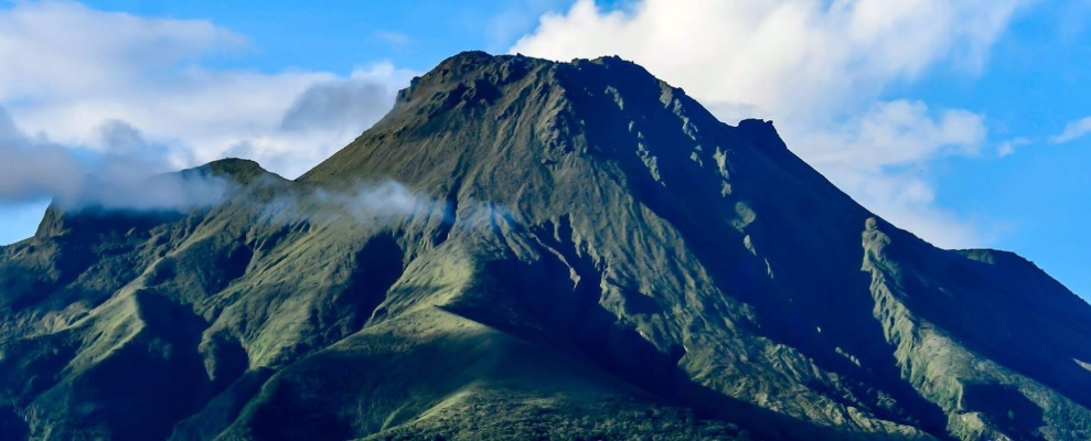
Indonesia , Merapi :
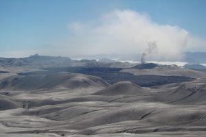
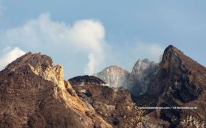
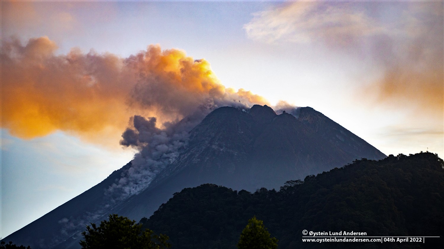
Report on the activity of Mount Merapi from August 26, 2022 to September 01, Published on September 02, 2022
RESULTS OF OBSERVATIONS
Visual
The weather around Mount Merapi is usually sunny in the morning and afternoon, while the evening is foggy. White smoke, thin to medium thickness, low pressure and 150 m high was observed from the Mount Merapi observation post of Babadan on September 01, 2022 at 12:07 WIB.
This week, 13 lava avalanches were observed in the Southwest, descending the Bebeng River with a maximum slip distance of 2000 m.
On the Southwest dome, there is no change in the height of the dome. For the central dome, no significant morphological change was observed. Based on photo analysis, the volume of the dome is still calculated at 1,664,000 m3, and for the central dome it is 2,772,000 m3.
Seismicity
This week, the seismicity of Mount Merapi showed:
589 Deep Volcanic Earthquakes (VTA),
28 shallow volcanic earthquakes (VTB),
184 multi-phase earthquakes (MP),
422 avalanche earthquakes (RF),
57 emission earthquakes (DG),
10 tectonic earthquakes (TT).
The intensity of this week’s seismicity is still quite high.
Deformation
Mount Merapi’s deformation that was monitored using EDM and GPS this week showed a distance shortening rate of 0.4 cm/day.
Rain and lahars:
This week, it rained at the Mount Merapi observation post with a recorded rain intensity of 0.5 mm/hour for a maximum of 35 minutes at the Kaliurang post on August 28 and 31, 2022. There was no no reports of lahars or additional flow in the rivers that originate from Mount Merapi.
Conclusion
Based on the results of visual and instrumental observations, it is concluded that:
The volcanic activity of Mount Merapi is still quite high in the form of effusive eruption activity. The state of the activity is defined at the « SIAGA » level.
Source : BPPTKG.
Photo : Oystein Lund Andersen.
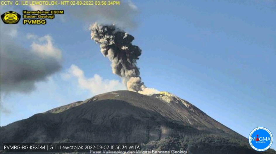
Indonesia , Ili Lewotolok :
Mount Ili Lewotolok presented an eruption on Friday, September 02, 2022 at 3:55 p.m. WITA with an ash column height observed at ± 1500 m above the summit (± 2923 m above sea level). The column of ash was white, gray / black with a thick intensity, oriented to the West and the North-West. This eruption was recorded on a seismograph with a maximum amplitude of 34 mm and a duration of 34 seconds.
VOLCANO OBSERVATORY NOTICE FOR AVIATION – VONA
Issued : September 02 ,20220902/0811Z
Volcano : Ili Lewotolok (264230)
Current Aviation Colour Code : ORANGE
Previous Aviation Colour Code : orange
Source : Ili Lewotolok Volcano Observatory
Notice Number : 2022LEW27
Volcano Location : S 08 deg 16 min 19 sec E 123 deg 30 min 18 sec
Area : East Nusa Tenggara, Indonesia
Summit Elevation : 4554 FT (1423 M)
Volcanic Activity Summary :
Eruption with volcanic ash cloud at 07h55 UTC (15h55 local). Eruption and ash emission is not continuing.
Volcanic Cloud Height :
Best estimate of ash-cloud top is around 9354 FT (2923 M) above sea level, may be higher than what can be observed clearly. Source of height data: ground observer.
Other Volcanic Cloud Information :
Ash-cloud moving to west, northwest
Remarks :
Seismic activity is Dominated by gas emission earthquakes
Source et photo : PVMBG.
Ecuador , Sangay :
DAILY REPORT OF THE STATE OF SANGAY VOLCANO, Friday September 2, 2022.
Information Geophysical Institute – EPN.
Surface activity level: High, Surface trend: Downward.
Internal activity level: High, Internal trend: No change.
Seismicity: From September 01, 2022, 11:00 a.m. to September 02, 2022, 11:00 a.m.:
Explosion (EXP) 257
Emission Tremors (TREMI ) 77.

Rains / Lahars:
No rain was recorded. **In the event of heavy rains, these could remobilize the accumulated materials, generating mudslides and debris that would descend on the flanks of the volcano and flow into the adjacent rivers.**
Emission / ash column:
There are no reports.
Other Monitoring Parameters:
FIRMS registers 17 thermal alerts and MIROVA registers 2 high thermal alerts (396 and 110 MW) in the last 24 hours
Gas:
The MOUNTS system reported 172.5 tons of SO2, measured on 2022-09-01 at 19:17 UTC
Observation:
Through images shared by ECU 911, incandescence was observed in the crater with rolling blocks on the eastern flank. Cloudy at the moment.
Alert level: Orange.
Source : IGEPN.
Photo : volcanian / dparedesb
La Martinique , Moun Pelée :
Weekly report of the activity of Mount Pelee for the period from August 26, 2022 to September 02, 2022.
Between August 26, 2022 at 4 p.m. (UTC) and September 02, 2022 at 4 p.m. (UTC), the OVSM recorded at least 11 volcano-tectonic earthquakes of magnitude less than 0.1. These low-energy earthquakes could not be located. These are earthquakes identical to those of the families on Pelee which are located inside the volcanic edifice between 0.4 / 2.6 km deep below the surface. This superficial volcano-tectonic seismicity is associated with the formation of micro-fractures in the volcanic edifice. None of these earthquakes was felt by the population.
During volcanic reactivation phases, periods of higher seismic activity often alternate with phases of lower seismicity. Since the reactivation of the hydrothermal-magmatic system (end of 2018), the OVSM has not recorded any earthquakes of volcanic origin during the month of May 2019 and less than 3 earthquakes in October 2019 and August 2020. This variability in the number of earthquakes has already, for example been observed following the reactivation of Soufrière de Montserrat.
An extension of two known areas of degraded vegetation located between Morne Plumé and the Chaude River was observed during a helicopter flight carried out on February 9 and May 5, with the support of Dragon 972, and confirmed by image analysis. satellites and drones (overflight of May 11) . A new area of degraded vegetation, located just north of the Chaude River, was observed from August 26th.
The alert level remains YELLOW: vigilance.
Source : OVSM-IPGP.
Photo : ville-saintemarie
Samoa Islands , Ta’u :
14°13’48 » S 169°27’14 » W,
Summit Elevation 3054 ft (931 m)
Current Volcano Alert Level: ADVISORY
Current Aviation Color Code: YELLOW
The earthquake swarm related to Taʻū Island continues with no significant change in the past 24 hours. Preliminary data analysis suggests a North-South area of possible earthquake locations extending from near the center point deep beneath Ta’u Island to shallower depths about 10 km (6 mi) to the north. The source of the earthquakes has not moved within the earth since monitoring began 3 weeks ago – the source position has remained constant. Seismologists continue to examine data and refine locations.
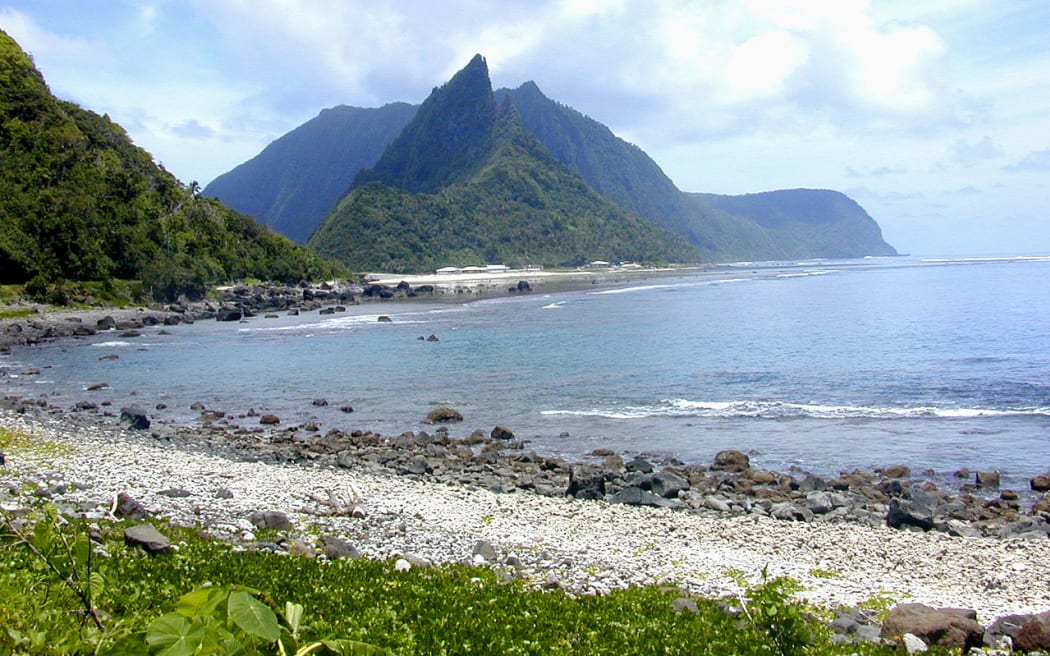
In the past 24 hours, there has been no change in the frequency or size of earthquakes. No volcanic activity was observed in available satellite data from the previous 24 hours.
It is unclear if this earthquake unrest will escalate to a volcanic eruption and exactly where an eruption might occur. An eruption could pose significant hazards to residents of American Samoa; these hazards include volcanic gases, volcanic ash, low-level localized explosions of lava, lava flows, earthquake shaking, and tsunami.
Source : HVO
Photo : rnz.co.nz