August 01 , 2022.
Iceland , Reykjanes Peninsula :
Update on the earthquake swarm in Fagradalsfjall mountain (Krýsuvík-Trölladyngja volcano) .
The situation is constantly changing. Update written at 12:07 UTC on 31-July-2022.
At the writing of this article at 11:32 UTC no eruption has started in Fagradalsfjall mountain or nearby area. Over 3000 earthquakes have been recorded in the last 24 hours in and around Fagradalsfjall mountain since the earthquake activity started yesterday (30-July-2022). There have not been any major changes in the crater in Fagradalsfjall mountain, it does seem to release more gas than normal.
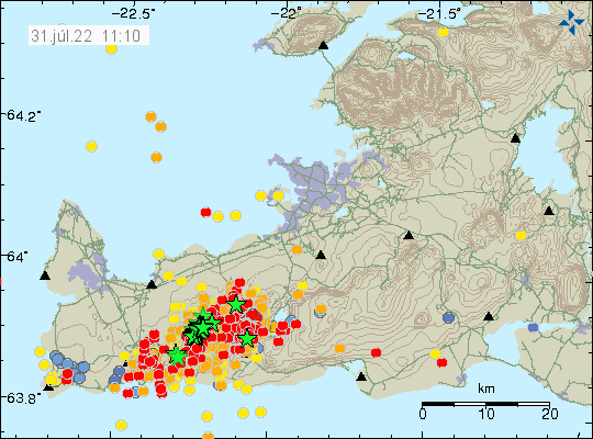
There has not been any major change in GPS location and that suggest that the area is as inflated as it possibly can be. It is impossible to know when the magma breaks up in the crust, but earthquake activity suggests that it has reached the depth of 2 km, meaning the magma has moved up a lot in the last 24 hours, since this earthquake activity started on the depth of 8 km yesterday.
At 3:14, an earthquake of magnitude M4.3 was detected about 4 km SSW of Fagradalsfjall. At 3:41 an earthquake of M4.2 was detected about 4 km N of Grindavík. At 4:51 an earthquake of M4.4 occurred around 3.3 km NW of Grindavík. Quite a few earthquakes over M3 have been detected tonight.
At 17:48 yesterday, an earthquake of magnitude M5.4 occurred about 3km ENE of Grindavík. It was felt east to Fljótshlíð and west to Snæfellsnes. This earthquake was a trigger earthquake, due to the magma intrusion by Fagradalsfjall.
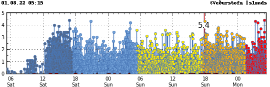
A strong seismic swarm is ongoing just northeast of Fagradalsfjall, and trigger earthquakes are occurring east and west of Fagradalsfjall. The activity started around noon yesterday and since then around 5,500 earthquakes have been recorded on the IMO’s automatic system.
Source : icelandgeology.net, Vedur is .
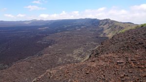
Hawaii , Kilauea :
19°25’16 » N 155°17’13 » W,
Summit Elevation 4091 ft (1247 m)
Current Volcano Alert Level: WATCH
Current Aviation Color Code: ORANGE
Activity Summary:
The summit eruption of Kīlauea Volcano, within Halemaʻumaʻu crater, has continued over the past 24 hours. All recent lava activity has been confined to the crater and current data indicate that this scenario is likely to continue. No significant changes have been noted at the summit or in either rift zone.
Summit Observations:
Eruption of lava from the Halemaʻumaʻu western vent into the active lava lake has continued over the past 24 hours. The lava level of the active lake surface remained at the level of the bounding levees. Over the last 24 hours, there were no significant ooze-outs along the margins of the crater floor. Summit tiltmeters show a gradual inflationary trend over the last 24 hours. A sulfur dioxide (SO2) emission rate of approximately 1,800 tonnes per day (t/d) was measured on July 27, 2022. Summit tremor is steady for this eruption’s long term base-line level.
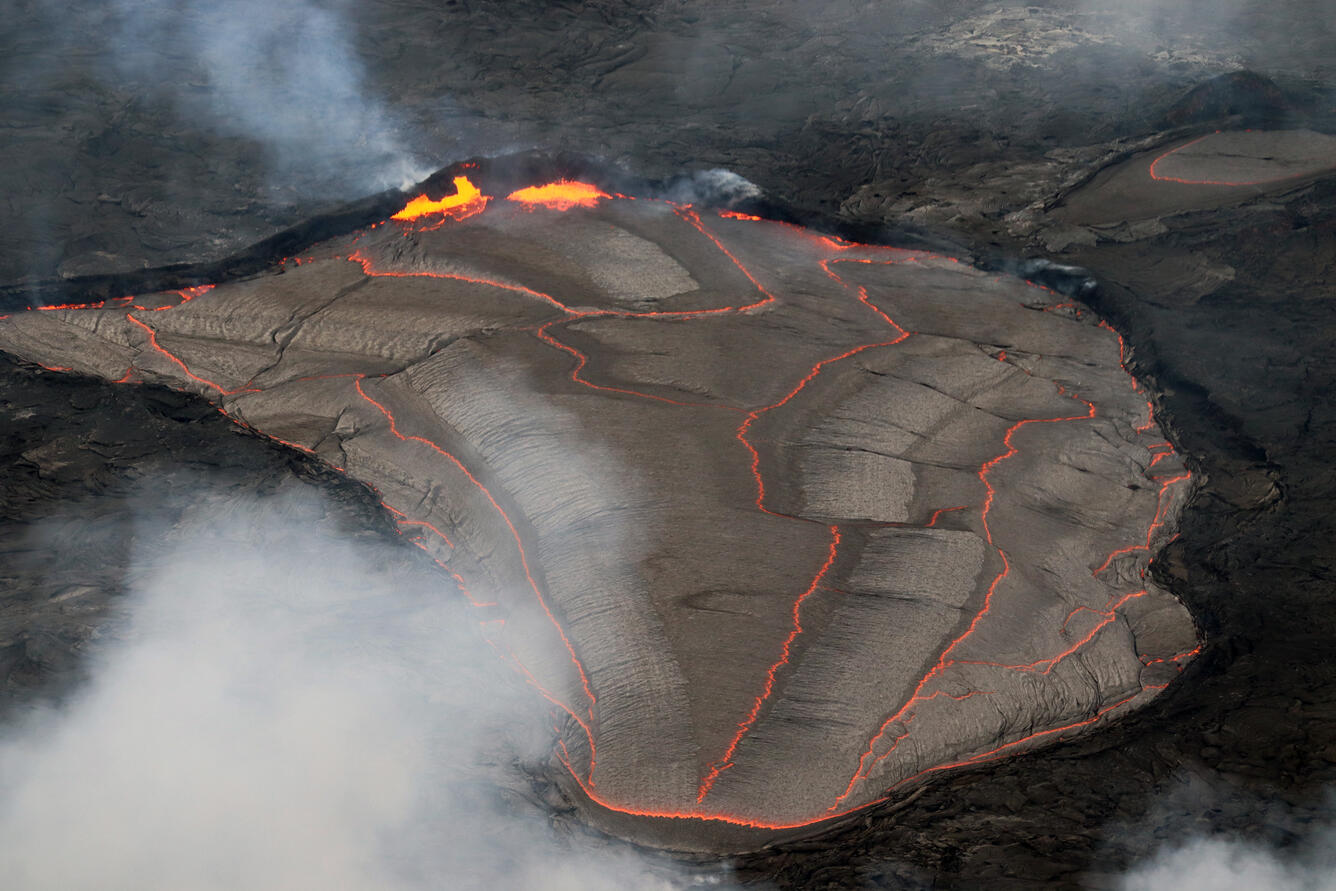
Lava lake activity continues in Halema‘uma‘u, at the summit of Kīlauea. This photo looks east, and shows that on June 24, the lava level was near the rim of the lake, with spattering along the east margin.
Rift Zone Observations:
No unusual activity has been noted along the East Rift Zone or Southwest Rift Zone; steady rates of ground deformation and seismicity continue along both. Measurements from continuous gas monitoring stations downwind of Puʻuʻōʻō in the middle East Rift Zone remain below detection limits for SO2, indicating that SO2 emissions from Puʻuʻōʻō are negligible.
Source : HVO
Photo : USGS / M. Patrick.
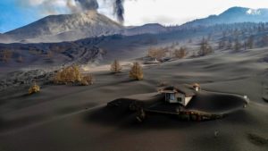
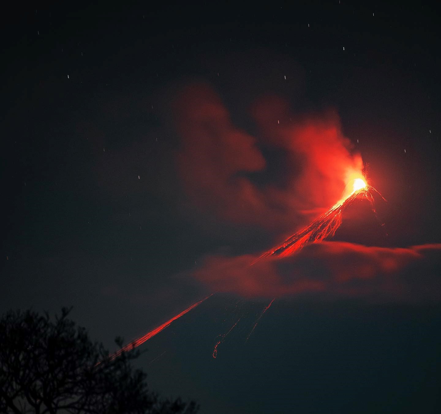
Indonesia , Semeru :
VOLCANO OBSERVATORY NOTICE FOR AVIATION – VONA
Issued : August 01 , 2022.
Volcano : Semeru (263300)
Current Aviation Colour Code : ORANGE
Previous Aviation Colour Code : orange
Source : Semeru Volcano Observatory
Notice Number : 2022SMR181
Volcano Location : S 08 deg 06 min 29 sec E 112 deg 55 min 12 sec
Area : East java, Indonesia
Summit Elevation : 11763 FT (3676 M)
Volcanic Activity Summary :
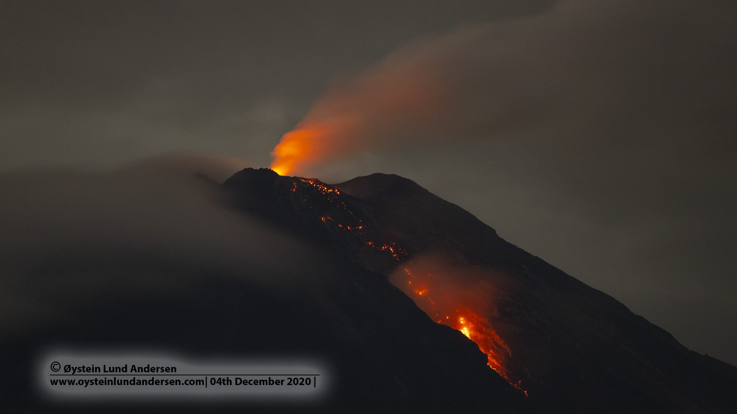
Eruption with volcanic ash cloud at 00h57 UTC (07h57 local)
Volcanic Cloud Height :
Best estimate of ash-cloud top is around 13363 FT (4176 M) above sea level, may be higher than what can be observed clearly. Source of height data: ground observer.
Other Volcanic Cloud Information :
Ash-cloud moving to southwest
SEISMICITY OBSERVATION:
We record:
20 earthquakes of eruptions/explosions with an amplitude of 11-20 mm and a duration of 60-75 seconds.
2 emission earthquakes with an amplitude of 5 to 8 mm and a duration of 55 to 60 seconds.
1 distant tectonic earthquake with an amplitude of 35 mm, S-P was not observed and the duration of the earthquake was 172 seconds.
Source : Magma Indonésie.
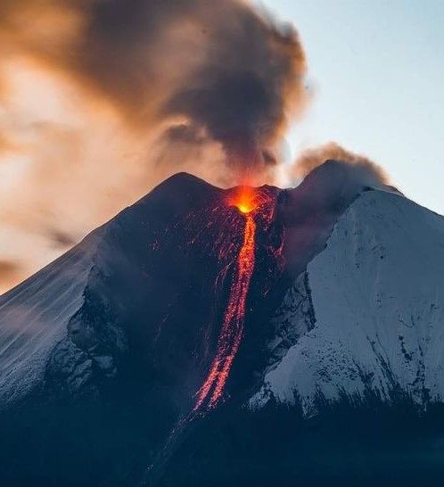
Photo : Oystein Lund Andersen .
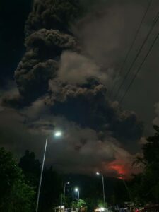
Ecuador , Sangay :
Information on the activity of the SANGAY volcano Nº 2022-063, Quito, Sunday July 31, 2022.
From 4:30 p.m. TL, through satellite images (GOES-16), a thin cloud of ash can be seen which reaches about 1 km above the crater and heads northwest. Therefore, there is a low probability of ash fall in the provinces of Morona Santiago and Chimborazo. This phenomenon has been persistent during the current eruptive period which began in May 2019. IG-EPN continues to monitor the event and will report in a timely manner if changes in seismic signals are detected.
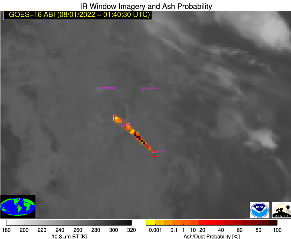
GOES-16 Satellite Image
The Geophysical Institute is monitoring and any news will be reported.
DAILY REPORT OF THE STATE OF SANGAY VOLCANO, Sunday July 31, 2022.
Information Geophysical Institute – EPN.
Surface activity level: High, Surface trend: Ascending.
Internal activity level: High, Internal trend: No change.
Seismicity: From July 30, 2022, 11:00 a.m. to July 31, 2022, 11:00 a.m.:
There were data transmission problems for about 6 hours and 20 minutes in the early morning, so the seismic statistics are incomplete.
Explosion (EXP) 180
Long Periods (LP) 6
Emission Tremors (TREMI ) 28
Rains / Lahars:
No rain was recorded in the area. **In the event of heavy rains, these could remobilize the accumulated materials, generating mudslides and debris that would descend on the flanks of the volcano and flow into the adjacent rivers.**
Emission / ash column:
According to the cameras, no emission was observed, however, the VAAC recorded 5 ash emission alerts observed on the satellites, which reached heights of 600 and 2400 meters above the level of the crater in a direction South -West.
Other Monitoring Parameters:
FIRMS satellite systems recorded 97 thermal anomalies and MIROVA recorded 1 high (328 MW) and 1 moderate thermal anomaly at Sangay in the last 24 hours.
Observation:
Cloudiness was permanent in the area, preventing direct observation of surface activity. Until the closing of this bulletin, users report noises similar to explosions and vibrations of windows, especially in the early hours of the morning in the cities of Nabón and San Fernando (province of Azuay), and Guayaquil, Samborondón and Salitre (Provindia de Guayas), due to the eruptive activity of the Sangay volcano and favorable atmospheric conditions that allow explosions to be heard at great distances. In addition, the SNGRE reported ash falls in the sectors of Guayaquil, Samborondon, Duran, Salitre and Daule, province of Guayas.
Alert level: Orange.
Source : IGEPN.
Photos : IGEPN , AlexBoasphoto.
Guatemala , Fuego :
Weather conditions: Clear weather
Wind ; East
3.8mm precipitation
Activity:
The Fuego OVFGO volcano observatory reports a weak fumarole at a height of 4,800 meters above sea level which disperses in a west and southwest direction. Incandescent pulses were observed at a height of 200 meters above the crater, these generate avalanches on the edge of the crater of weak to moderate characteristics. Low sounds similar to those of a locomotive continue to be heard constantly.
The lava flow towards the Ceniza ravine is 1,000 meters long. From its front, it generates constant weak to moderate avalanches. In the descent of these avalanches a curtain of ash is raised with a height of 500 meters from the surface, which is scattered to the west and southwest. As a result of this activity, ash falls are reported in the areas of Panimaché I, Morelia, Santa Sofía, El Porvenir, Sangre de Cristo, Finca Palo Verde, Yepocapa and others. Due to wind variability, there is a likelihood of ash fall in communities northwest of the volcano, such as Quisaché and nearby communities.
Source : Insivumeh
Photo : Diego Rizzo