November 04 , 2021.
Italy / Sicily , Etna :
Weekly bulletin from October 25, 2021 to October 31, 2021 (issue date November 02, 2021)
SUMMARY STATEMENT OF ACTIVITY
In view of the monitoring data, it is highlighted:
1) VOLCANOLOGICAL OBSERVATIONS: Degassing activity of summit craters; sporadic and modest ash emissions from the Southeast Crater
2) SEISMOLOGY: Weak seismic activity of fracturing; the amplitude of the volcanic tremor remained mainly at medium-low levels.
3) INFRASOUND: Moderate infrasound activity.
4) DEFORMATIONS: During the last week, the GNSS and inclinometric networks did not show any significant changes.
5) GEOCHEMISTRY: The flow of SO2 is at an average level
The flux of CO2 emitted by soils is characterized during the last week by values that fluctuate from high to very high, with a peak at 01 m.c.
The partial pressure of CO2 dissolved in water does not show significant variations.
The helium isotope ratio appears on average to high values (latest data from 10/20/2021) with a slight decrease.
There are no updates for the C / S report.
6) SATELLITE OBSERVATIONS: The thermal activity in the summit area was at a low level.
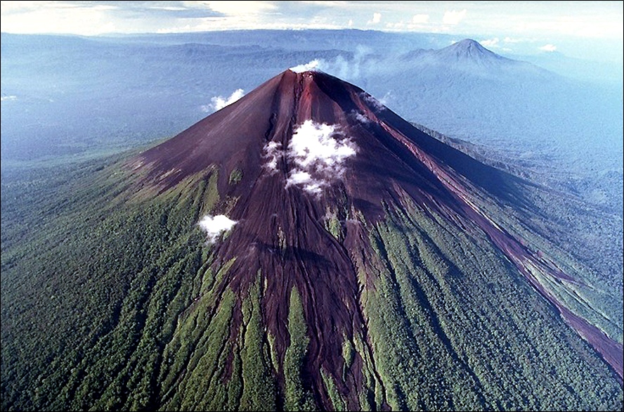
VOLCANOLOGICAL OBSERVATIONS
During the week, the monitoring of the volcanic activity of Etna was carried out by analyzing the images of the network of surveillance cameras of the INGV section of Catania, Osservatorio Etneo (INGV-OE). Except for a few brief and rare moments of cloud opening, prohibitive weather conditions made observations virtually impossible.
However, it is evident that the usual activity of degassing the summit craters continued.
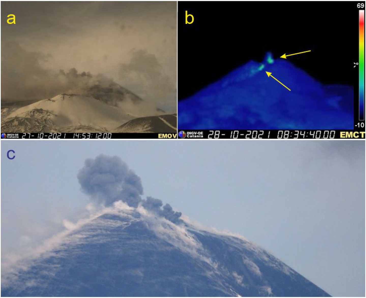
Fig. 3.2 – Emissions of ash from the SEC, October 27-28, 2021. (a) October 27, image of the visual surveillance camera on Montagnola (EMOV, high south slope of Etna). (b) October 28. Zoom on the SEC extracted from the image of the thermal surveillance camera on Monte Cagliato (EMCT, eastern slope of Etna). The yellow arrows indicate two thermal anomalies, corresponding to ash emission points. (c) October 28, seen from Tremestieri Etneo (south side of Etna).
In some of the rare and brief moments of visibility, during the afternoon of October 27 and the morning of October 28, small ash emissions were observed from the Southeast Crater (SEC; Figure 3.2). In particular, two emission points were observed, as indicated by the yellow arrows in Figure 3.2b. However, on the afternoon of October 28, these broadcasts ceased and no more were seen or reported over the following days. These moments of visibility also made it possible to observe the degassing characteristic of all the summit craters, accentuated by the conditions of atmospheric humidity.
Volcanic tremor:
The time trend of the mean amplitude of the volcanic tremor remained mainly at a medium-low level throughout the week, except for a few fluctuations in the amplitude, up to high values, recorded on October 25. . The location of the source of the tremor is located in the area between the Southeast Crater and Bocca Nuova, at a depth of about 3,000 meters above mean sea level.
Source : INGV.
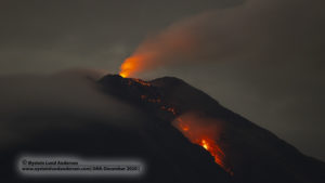
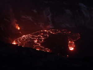
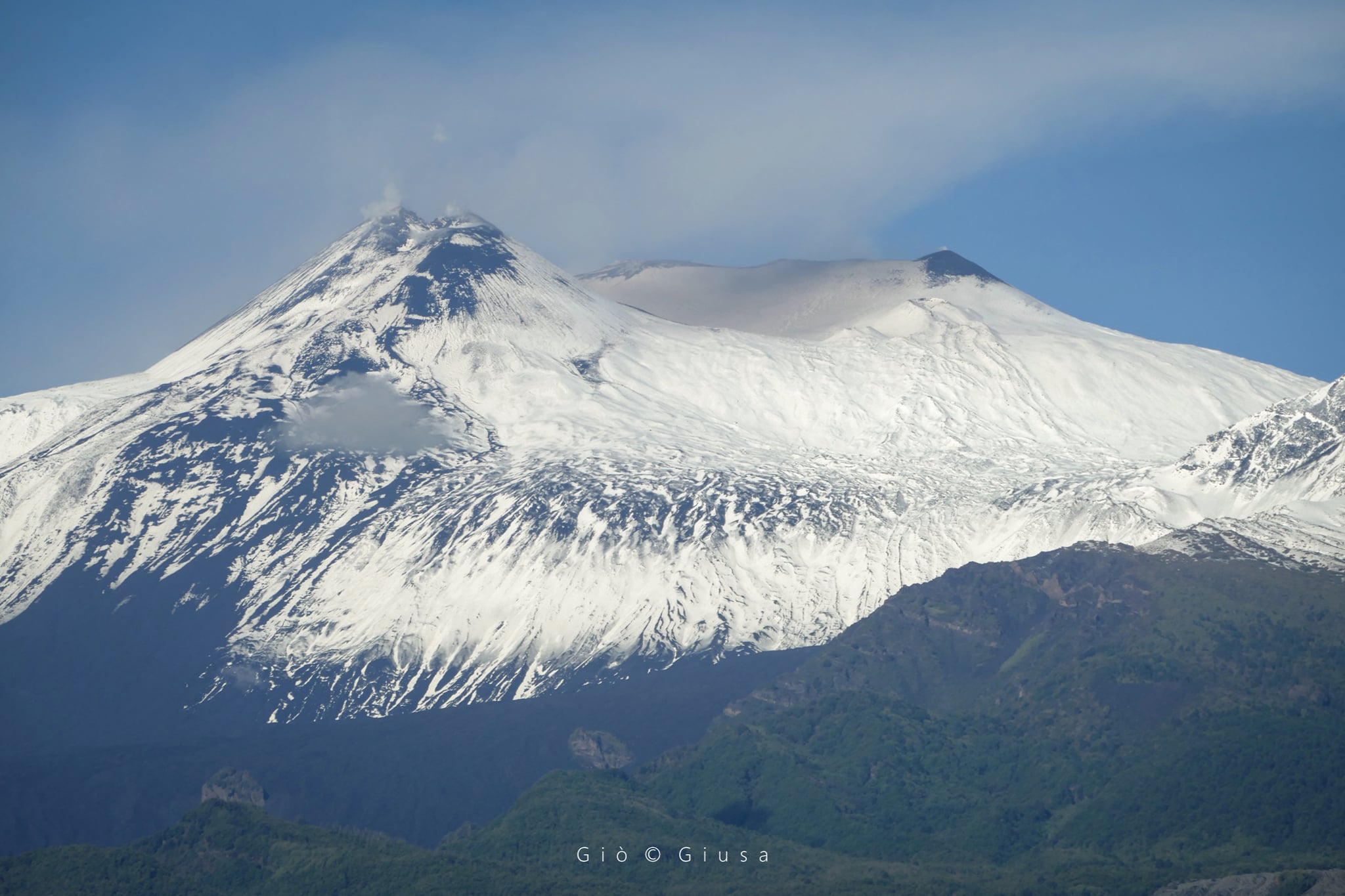
Photos : Gio Giusa , ingv.
Spain / La Palma , Cumbre Vieja :
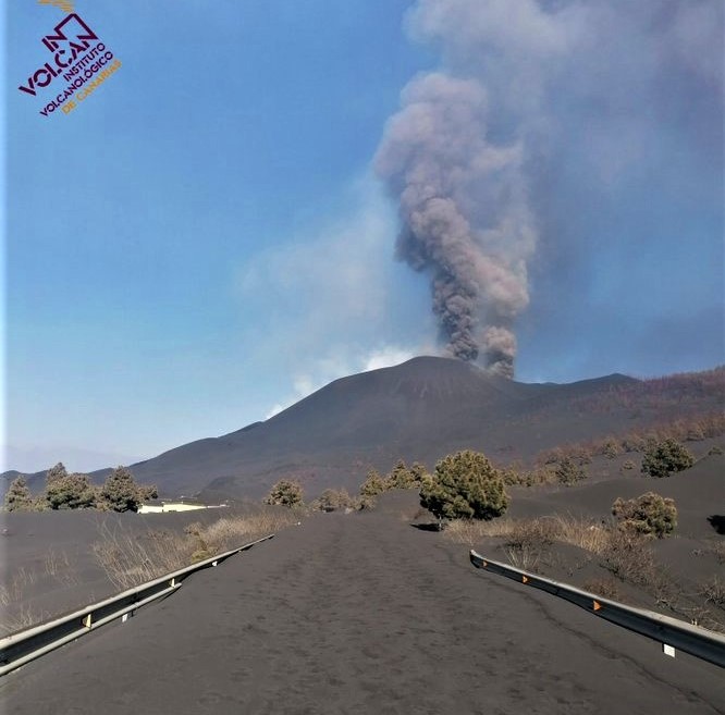
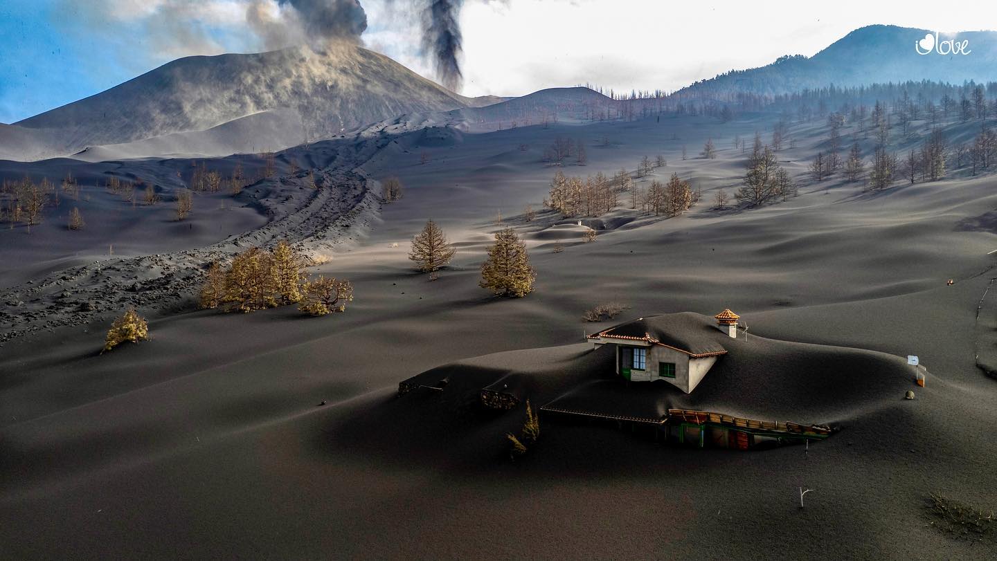
03 November 2021 09:00 UTC. Eruptive activity continues on La Palma.
Since the last declaration, 130 earthquakes have been located in the area affected by the volcanic reactivation of Cumbre Vieja, 16 of these earthquakes were felt by the population, having reached the maximum intensity in the epicentral zone IV-V (EMS98) for two earthquakes.
The most important earthquake is the one which occurred today at 07:27:39 (UTC), with a magnitude of 5.0 mbLg at 35 km depth and felt throughout the island of La Palma and by certain populations of the islands of La Gomera and Tenerife. . This earthquake was preceded by another, 3 seconds before, of magnitude 4.8 mblg, at a depth of 36 km, so the sensation in the perceptibility of the population was of longer duration, because the effects of two earthquakes mix.
During the period considered, 5 earthquakes were located at depths of about 30 km, the rest of the hypocenters of the period are located at a shallower depth, about 12 km.
The amplitude of the volcanic tremor signal persists at lower levels, without intensifying pulses.
The island’s network of permanent GNSS stations does not show a clear tendency to warp from stations closest to eruptive centers, while at more distant stations a slight deflation is maintained, possibly related to deep seismicity. .
In view of the calibrated image, an emission column height of 2,700 m is estimated at 07:45 UTC.
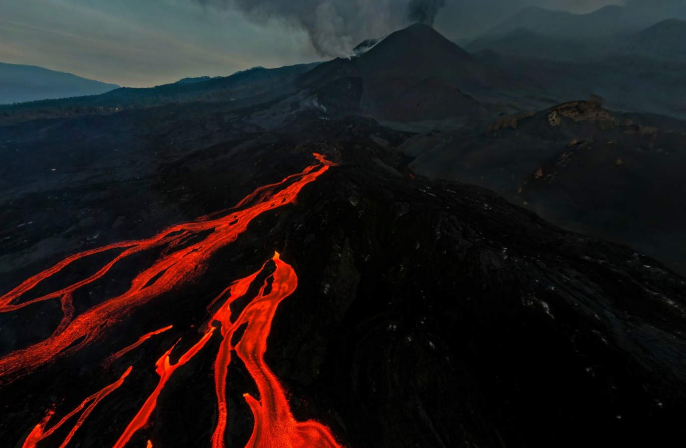
The activity levels visible in the cone were highly variable throughout the day, with occasional pulses and high lava emission rates.
As for the cloud of ash and sulfur dioxide, it should turn to the south, and therefore, from this afternoon, will improve the weather scenario for the operation of La Palma airport.
The maximum magnitude was 5.0 mbLg for an event today at 7:27 a.m. at a depth of 35 km, felt with maximum intensity IV-V (EMS).
Extremely unfavorable levels of PM10 particles are maintained at the Los Llanos de Aridane station. In the rest of the stations, the air quality levels for PM10 particles are good or reasonably good.
The Cumbre Vieja volcano, on the island of La Palma, has been showing positive signs for several days, with sulfur dioxide (SO₂) and tremor values falling. However, scientists warn that these indicators are still too high to even talk about the end of the eruption.
As of noon yesterday, the volcanic tremor signal started to descend and today Wednesday it still remains at low levels. Likewise, SO₂ emissions associated with the volcanic plume yesterday recorded a value of 9,600 tonnes per day, a downward trend that has been repeated for several days.
The national director of volcanic monitoring of the National Geographic Institute (IGN) and spokesperson for the Scientific Committee of Pevolca, Carmen López, stressed during a press conference that these are « positive signs » but warned that these downward trends « need to be accentuated » as « values are still very high ».
Source : IGN es , El Pais.
Photos : Involcan , I love the world .
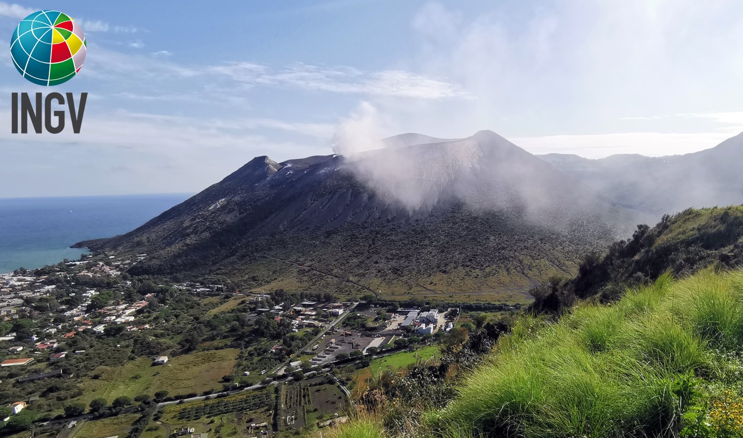
Italy , Stromboli :
Weekly bulletin from October 25, 2021 to October 31, 2021 (issue date November 02, 2021)
SUMMARY STATEMENT OF ACTIVITY.
In view of the monitoring data, it is highlighted:
1) VOLCANOLOGICAL OBSERVATIONS: During this period a normal explosive activity of strombolian type with splash activity was observed. The total hourly frequency of explosions fluctuated between medium-high and high values (15-24 events / h). The intensity of the explosions varied from low to high in the North crater area and low in the Center-South area.
2) SEISMOLOGY: The seismological parameters monitored do not show significant variations, with the exception of the landslide signal recorded at 17:28 UTC on October 25, 2021 and the ML 2.1 magnitude earthquake recorded at 20:54 UTC on the 31st October 2021 and located in the Aeolian Islands region (Messina).
3) DEFORMATIONS: The island’s soil deformation monitoring networks did not show any significant changes to report for the period under review.
4) GEOCHEMISTRY: The flow of SO2 at a medium-high level
There is no update of the values of the CO2 flux emitted by the ground on the Pizzo compared to the previous bulletin, in which the values were at medium-high levels.
There are no updated values of the C / S ratio from the previous bulletin, in which the values were at average levels.
There is no update of the isotopic ratio of Helium dissolved in the Stromboli thermal aquifer, where the values were at high levels.
5) SATELLITE OBSERVATIONS: The thermal activity in the summit area is at a low level.

VOLCANOLOGICAL OBSERVATIONS.
The N1 crater located in the North zone produced explosions of medium to high intensity (the products of many explosions exceeded 150 m in height) emitting coarse materials (lapilli and bombs). Vent N2, with three emission points, showed low intensity explosive activity (less than 80 m in height) emitting coarse materials with sometimes intense throwing activity on October 27, 30 and 31. The average frequency of explosions varied from 8 to 14 events / h. In the Center-South zone, sector S1 showed a few sporadic explosions emitting coarse materials with low intensity, while the three vents located in sector S2 produced explosions, even simultaneous, of low intensity emitting coarse materials. Sector C did not show explosive activity emitting coarse materials with low intensity until October 26. There the frequency of explosions was between 5 and 12 events / h
Source : INGV.
Photos : Stromboli Adventures.
Italy , Vulcano :
Weekly bulletin from October 25, 2021 to October 31, 2021 (issue date November 02, 2021)
SUMMARY STATEMENT OF ACTIVITY.
In view of the monitoring data, it is highlighted:
1) Temperature of the fumaroles of the crater: The temperatures recorded both on the edge of the crater and on the internal face are slightly increasing.
2) CO2 flux in the crater area: There is no update of the CO2 flux in the VCS site; the latest data (dated 20.10.202) indicated very high values.
3) SO2 flow in the crater area: SO2 flow occurs at a high level of degassing
4) Geochemistry of fumarolic gases: no update is available
5) CO2 fluxes at the base of the La Fossa cone and in the Vulcano Porto area: very high CO2 flux values in the sites of Rimessa, C. Sicilia and Palizzi (P4max); values in line with those of last week on the Faraglione site.
6) Geochemistry of thermal aquifers: temperature and conductivity values slightly increasing in the C. Sicilia well; the temperatures recorded are anyway on very high values while the conductivity on very low values; in the Bambara well, the level remains constant, while the conductivity continues to increase.
7) Local seismicity: Slight decrease for higher frequency tremors and slight increase for VLP type events.
8) Regional seismicity: Modest fracturing seismicity with Ml> = 1.0. A group of low energy earthquakes (maximum Ml equal to 2.2) occurred in a focal volume located about 3 km east of Porto di Ponente.

9) Deformations – GNSS: GNSS data show that after the strong variations recorded between mid-September and mid-October, during the last week there were no significant deformations
10) Deformations – Inclinometry: The inclinometric network shows that after the variations recorded between September 13 and October 10, there are no significant variations.
11) Other observations: Gravimetry: There are 3 slight variations in amplitude, of local nature, visible only at the VSOCR station.
TEMPERATURE OF FUMEROLLES FROM THE CRATER.
The signals acquired by the Vulcra station (signals T_2 and T_3 in the figure) have been characterized during the last week by a strong noise caused by repeated rains; this made the data validation discontinuous; the maximum temperature channel (T_2) recorded maximum values of 376 ° C; As the percentage of validated data is low (24%), the average and minimum values are not considered representative of actual thermal conditions. The F5 fumarole has a validation percentage of 100%, but shows a much more disturbed signal (recorded range 80-348 ° C). The continuously monitored temperatures on the internal side (Vulcra2 station) show a range of values between 108 and 112 ° C; the positive trend continues, little pronounced but continues; on this measurement site, the weekly rains did not disturb the emission temperature.
CO2 FLOWS AT THE BASE OF THE CONE DE LA FOSSA AND IN THE ZONE OF VULCANO PORTO.
The CO2 flows automatically acquired at the Rimessa and C. Sicilia sites show a modest increase on the last days of the week and remain at very high values. Also on the Palizzi site (P4max), the flow rates are constantly at very high values. In the faraglione site no significant variation is observed and the flow values recorded are in line with those of last week.
Source : INGV.
Photos : INGV.
Papua New Guinea , Ulawun :
RVO reported increased unrest at Ulawun. Very small discrete seismic events had been recorded for the past several months by the seismometer located on the SW flank, 5 km from the summit. A small thermal anomaly was identified in satellite images at around 05h00 on 3 November. At approximately 08h00 RSAM values increased to 100, and by 11h15, had risen to 1,400. The values fluctuated between 100 and 1,000 units at least through 1300 when the data was summarized. Tremor was detected on a seismometer at Ulamona, 11-12 km NW from the summit, during periods with higher RSAM values. Steam emissions rose from the crater.
The symmetrical basaltic-to-andesitic Ulawun stratovolcano is the highest volcano of the Bismarck arc, and one of Papua New Guinea’s most frequently active. The volcano, also known as the Father, rises above the N coast of the island of New Britain across a low saddle NE of Bamus volcano, the South Son. The upper 1,000 m is unvegetated. A prominent E-W escarpment on the south may be the result of large-scale slumping. Satellitic cones occupy the NW and E flanks. A steep-walled valley cuts the NW side, and a flank lava-flow complex lies to the south of this valley. Historical eruptions date back to the beginning of the 18th century. Twentieth-century eruptions were mildly explosive until 1967, but after 1970 several larger eruptions produced lava flows and basaltic pyroclastic flows, greatly modifying the summit crater.
Sources : GVP , RVO.
Photo : Ulawun with Bamus behind it to the right. © dandees, via Panoramio.
Japan , Fukutoku-OkanoBa :
The Japan Coast Guard reported that floating pumice from the mid-August Fukutoku-Oka-no-Ba eruption had arrived at coastlines more than 1,000 kilometers away in early October. The pumice first arrived at Kitadaito Island (1,035 km W) on 8 October. In late October pumice circled Okinawa and Maejima islands (1,422 km W) and several ports in the Kagoshima prefecture (1,322 NW). The pumice damaged hundreds of boats and ships, clogged harbors, and impacted the fishing and tourism industries in several areas. Several local governments began the process of removing the pumice from the water.

This view of Fukutoku-Oka-no-Ba on 3 July 2005 from the NE shows a plume of debris and discoloration extending from the arrow. The island in the background is Minami-Ioto.
Fukutoku-Oka-no-ba is a submarine volcano located 5 km NE of the pyramidal island of Minami-Ioto. Water discoloration is frequently observed from the volcano, and several ephemeral islands have formed in the 20th century. The first of these formed Shin-Ioto (« New Sulfur Island ») in 1904, and the most recent island was formed in 1986. The volcano is part of an elongated edifice with two major topographic highs trending NNW-SSE, and is a trachyandesitic volcano geochemically similar to Ioto.
Source : GVP
Photo : GVP / courtesy of Japan Maritime Security and Safety Agency, 2005.