May 17 , 2022.
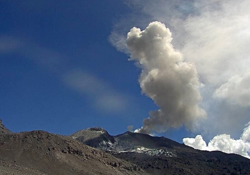
Italy / Sicily , Etna :
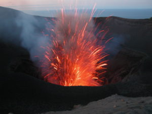
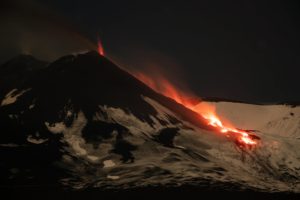
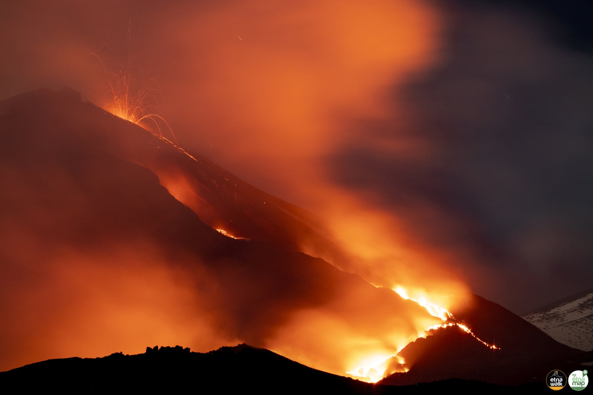
At the end of the afternoon of May 12, 2022, a new eruptive fracture opened on the northern flank of the Southeast Crater of Etna, from which a modest lava flow was emitted. This activity was preceded by repeated emissions of ash and steam from a new vent, which had opened just below the northern rim of the crater, on the top of the cone flank. On May 14, ash emissions from this vent resumed, and weak incandescent jets were observed at dusk. The lava flow initially expanded very slowly, but by May 15 it had reached a length of over 1 km, with a front at around 2600 m. In the evening of the same day, weak Strombolian activity was underway at the vent below the SEC edge; the next morning the lava front reached an altitude of 2500 m.
Still no statement from the INGV.
Source : Boris Behncke.
Photo : Etna Walk / Giuseppe Distefano / Marco Restivo.
Iceland , Reykjanes Peninsula :
Earthquakes on the Reykjanes peninsula.
Aviation color code elevated from green to yellow. 16.5.2022
More than 3000 earthquakes have been automatically detected nearby Eldvörp in the Reykjanes/Svartsengi volcanic system in the past week. Since yesterday (15.05), nine earthquakes had magnitude above M3 and two above M4. The largest event had a magnitude of M4.3 occurred on 15.05 at 17:38 UTC. The seismicity is located at a depth between 4 and 6 km.
Recent deformation observations (both cGPS and InSAR) identified the onset of a new inflation event west of Thorbjörn likely caused by magma intrusion. Preliminary modelling results indicate the source is located at a depth between 4-5 km.
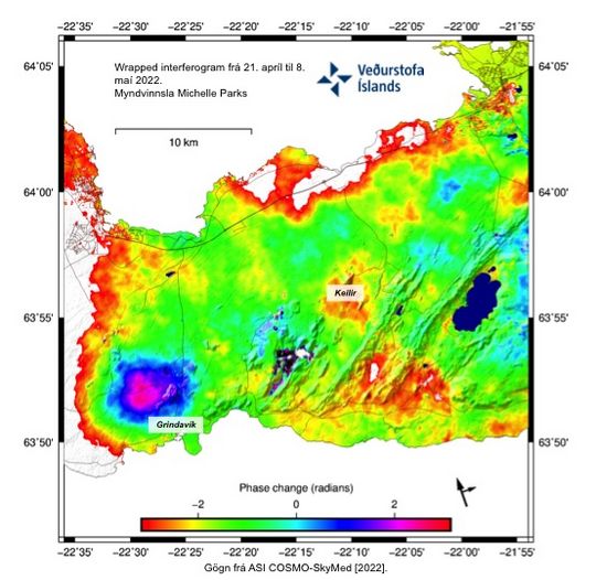
Recent deformation observations (both cGPS and InSAR) identified the onset of a new inflation event west of Thorbjörn, most likely the result of a magmatic intrusion. Preliminary modelling results indicate the source is located at a depth between 4-5 km. (The Icelandic Met office/Michelle Maree Parks)
In light of the increased seismic activity and the ongoing deformation in the Reykjanes/Svartsengi volcanic system the aviation color code is elevated from GREEN to YELLOW.
The Civil Protection Department of Iceland elevated their alert level to UNCERTAINTY level on 15.05.
Source : Vedur is.
New Zealand , Ruapehu :
Volcanic tremor at Mt Ruapehu lowers from strong to moderate: Published: Tue May 17 2022 10:40 AM
Volcanic Alert Level remains at 2
Aviation Colour Code remains at Yellow
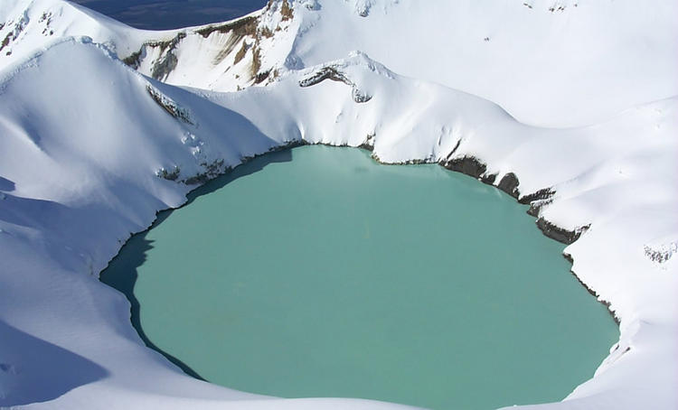
Volcanic tremor continues at Mt Ruapehu but has decreased since last week, lowering from strong to moderate levels. The Crater Lake (Te Wai ā-moe) temperature has also declined to 37°C. The levels of gas emission remain high, indicating that the volcano is still at a heightened level of unrest. The Volcanic Alert Level remains at 2.
The strong volcanic tremor at Mt Ruapehu that has been recorded since early-March has been declining for the past two weeks. The heavy rainfall over the weekend caused a temporary 40 cm rise in lake level and a drop of about 2°C in water temperature. The lake level has returned to the normal pre-rainfall level. Aside from the short-term impact of this weather event, the crater lake temperature has decreased from a peak of 41 °C on 8 May 2022 to 37 °C today.
A gas measurement flight on 13 May 2022 confirmed high sulphur dioxide (SO2) and carbon dioxide (CO2) gas output, respectively of 179 and 1658 tonnes per day of gas. Both gases are released from relatively shallow magma, and although the gas output values are lower than the values measured two weeks ago, they remain elevated for Mt Ruapehu. Observations from the gas flight have also confirmed the upwelling in the northern vent areas of the lake continues.
Overall, even with the lower levels of volcanic tremor and decrease in lake temperature, gas emissions remain elevated, and the period of heightened volcanic unrest continues at Mt Ruapehu. Within the next four weeks, the most likely outcome of this unrest episode is minor eruptive activity that is confined to the lake basin, or no eruptions. This level of activity may generate lahars (dangerous volcanic mudflows) in the Whangaehu River.
The next most likely scenario is a larger eruption that impacts the summit plateau with volcanic surges and generates lahars in multiple catchments, like what was seen after the September 2007 eruption, or older events like those in 1975 and 1969. An eruption of this size would cause life-threatening hazards on the summit plateau and in valleys impacted by lahars.

The chance of a prolonged eruptive episode or a larger eruption, such as occurred in 1995-96 with wider ashfall impacts, is higher than it was two months ago, but within the next four weeks remains very unlikely. Such an eruption would most likely only follow a sequence of smaller eruptions.
Due to the heightened volcanic unrest, GNS Science staff are carrying out more frequent aerial observations and gas measurements when weather conditions are suitable.
Our interpretation of the observational data and activity is consistent with elevated volcanic unrest at the heightened level and therefore the Volcanic Alert Level remains at Level 2. The Aviation Colour Code remains at Yellow.
Source : Geonet / Agnès Mazot / Duty Volcanologist
Photos : Geonet , Bradd Scott .
Peru , Sabancaya :
Analysis period: from May 09, 2022 to May 15, 2022, Arequipa, May 16, 2022.
Alert level: ORANGE
The Geophysical Institute of Peru (IGP) reports that the eruptive activity of the Sabancaya volcano remains at moderate levels, that is to say with the recording of an average of 54 daily explosions, with columns of ash and of gas up to 2.5 km altitude above the summit of the volcano and their subsequent dispersion. Therefore, for the following days, no significant change is expected in eruptive activity.
The IGP recorded and analyzed the occurrence of 406 earthquakes of volcanic origin, associated with the circulation of magmatic fluids inside the Sabancaya volcano. An average of 54 explosions was recorded daily, in addition to recording Volcano-Tectonic (VT) type events associated with rock fracturing inside the Sabancaya volcano.
Monitoring the deformation of the volcanic structure using GNSS techniques (processed with fast orbits) does not show any significant anomalies. However, in general, an inflation process has been observed in the northern sector (surroundings of the Hualca Hualca volcano). Visual surveillance identified columns of gas and ash up to 2.5 km above the summit of the volcano, which were scattered towards the southern, southeastern and northeastern sectors of Sabancaya. Satellite recordings have identified the presence of 5 thermal anomalies, with a maximum value of 68 MW, associated with the presence of a lava body on the surface of the volcano’s crater.
RECOMMENDATIONS
• Keep the volcanic alert level orange.
• Do not approach within a radius of less than 12 km from the crater.
Source : Cenvul
Photo : Ingemmet.
Kamchatka , Karymsky :
VOLCANO OBSERVATORY NOTICE FOR AVIATION (VONA)
Issued: May 16 , 2022
Volcano: Karymsky (CAVW #300130)
Current aviation colour code: ORANGE
Previous aviation colour code: orange
Source: KVERT
Notice Number: 2022-35
Volcano Location: N 54 deg 2 min E 159 deg 26 min
Area: Kamchatka, Russia
Summit Elevation: 1486 m (4874.08 ft)
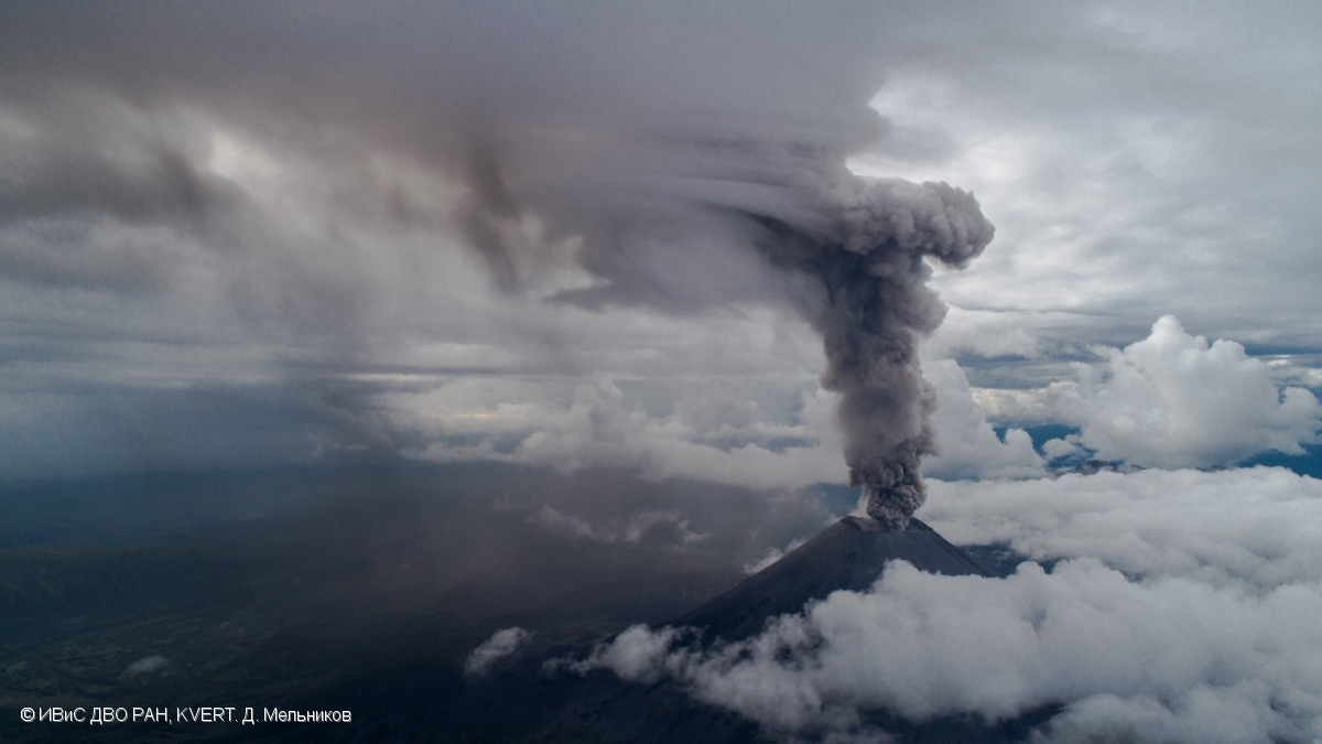
Volcanic Activity Summary:
A moderate eruptive activity of the volcano continues. The explosions sent ash up to 3.5 km a.s.l., the ash plume is extending for 20 km to the east-northeast of the volcano.
A moderate explosive activity of the volcano continues. Ash explosions up to 12 km (39,400 ft) a.s.l. could occur at any time. Ongoing activity could affect international and low-flying aircraft.
Volcanic cloud height:
3500 m (11480 ft) AMSL Time and method of ash plume/cloud height determination: 20220516/2110Z – Himawari-8
Other volcanic cloud information:
Distance of ash plume/cloud of the volcano: 20 km (12 mi)
Direction of drift of ash plume/cloud of the volcano: E / azimuth 80 deg
Time and method of ash plume/cloud determination: 20220516/2130Z – Himawari-8
Source : Kvert.
Photo : D. Melnikov, IVS FEB RAS, KVERT.
Hawaii , Kilauea :
19°25’16 » N 155°17’13 » W,
Summit Elevation 4091 ft (1247 m)
Current Volcano Alert Level: WATCH
Current Aviation Color Code: ORANGE
Activity Summary:
The summit eruption of Kīlauea Volcano, within Halemaʻumaʻu crater, has continued over the past 24 hours. All recent lava activity has been confined to the crater, and current data indicate that this scenario is likely to continue. No significant changes have been noted in the summit or East Rift Zone.

A wide view of Halema‘uma‘u crater, at the summit of Kīlauea, looking east. Volcanic gas emission rates remain elevated, with sulfur dioxide measured at about 2,800 tonnes per day on May 12. Volcanic gasses are emitted from the west vent complex, the active lava lake, and from other cracks around the crater floor. USGS photo taken by L. DeSmither on May 11, 2022.
Halemaʻumaʻu crater Lava Lake Observations:
Eruption of lava from the Halemaʻumaʻu western vent into the active lava lake and onto the crater floor has continued over the past 24 hours. The active lava lake has shown continuous surface activity, with lake level remaining relatively high, with some minor fluctuations in level. Lava ooze-outs were active over the course of the day, though slightly diminished compared with earlier last week and mostly on the eastern margin of the crater. Overflight measurements on May 10, 2022 indicated that the crater floor had seen a total rise of about 106 meters (348 feet) and that 77 million cubic meters (20 billion gallons) of lava had been effused since the beginning of this eruption on September 29, 2021.
Summit Observations:
Summit tiltmeters showed continued weak deflation over the past 24 hours. A sulfur dioxide (SO2) emission rate of approximately 2,800 tonnes per day (t/d) was measured on May 12, 2022.
Source : HVO
Photo : USGS/ L. DeSmither , 11 mai 2022.