April 06 , 2020 .
La Réunion , Piton de la Fournaise :
Activity bulletin of Sunday April 5, 2020 at 11:00 am (local time)
Alert level: 2-2
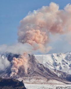
Following a reconnaissance flight by the SAG and the PGHM carried out this morning around 10:30 am local time, the casting front could be located with precision (white star in Figure 1). It was 550 m above sea level, about 2.7 km from national road 2 (compared to 800 m above sea level and 3 km from the road yesterday at 6:52 pm).
Note that from an altitude of 400m the slopes will be much less steep (12-13% on average) which will have the consequence of slowing the spread of the flow.
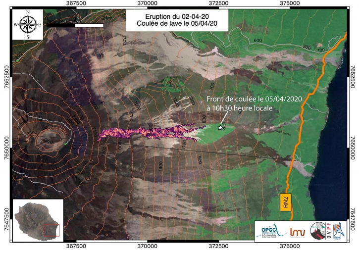
Figure 1: Mapping of the lava flow dated 4/4/2020 at 18:52 local time. The white star represents the position of the flow front at 10:12 local time on 5/4/2020 (© OVPF / IPGP / LMV / OPGV).
The observations made at the eruptive site were difficult given the cloud cover but they reported a single crack, particularly active, confirming the increase in flows recorded by satellite method and by the fluxes of SO2 in the air. (15-25 m3 / sec on average).
Activity bulletin of Sunday April 5, 2020 at 5:00 p.m. (local time)
Alert level: 2-2
The eruption which started on 02/04/2020 on the eastern flank of Piton de la Fournaise, around 12:20 local time, continues. The intensity of the volcanic tremor (indicator of the intensity of the eruption) has been relatively stable over the past 24 hours (Figure 1).
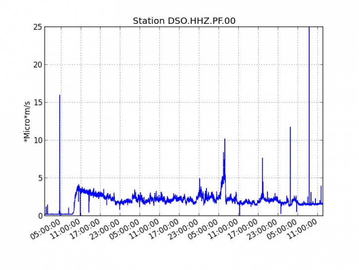
Figure 1: Evolution of the RSAM (indicator of the volcanic tremor and the intensity of the eruption) since 02/04/2020 00h UT time (04h local time) on the seismic station DSO located at the top of the volcano. (© OVPF / IPGP).
Strong seismic activity has been recorded under the summit craters since this morning, so over the past 12 hours, 56 volcano-tectonic earthquakes have been recorded. These earthquakes are located about 2 km deep below the southeast edge of the Dolomieu crater (Figure 2).
These earthquakes testify to the weakening of the environment, either by a circulation of fluid or the emptying of a reservoir, most certainly in connection with the supply of the eruptive site and its revival of activity since approximately 24 hours.
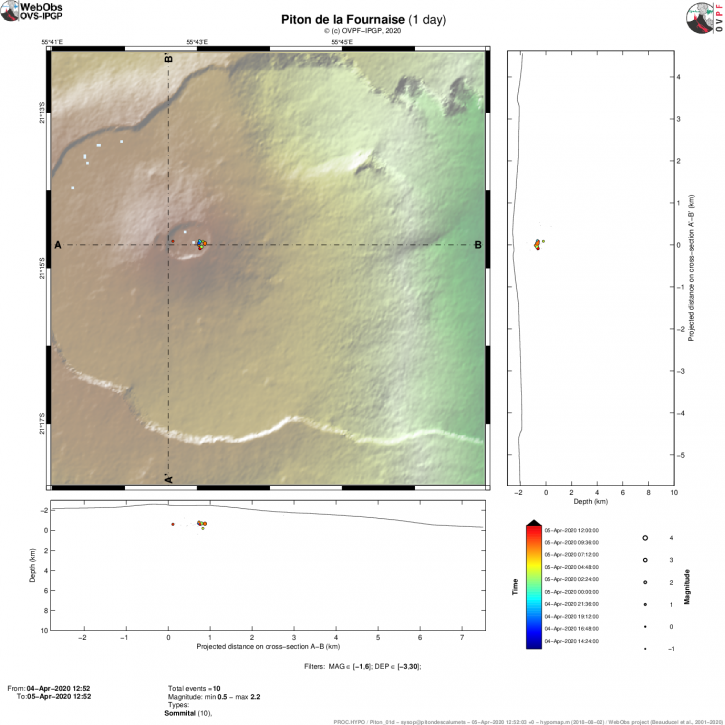
Figure 2: Location map (epicenters) and north-south and east-west sections (showing the location in depth, hypocenters) of earthquakes recorded and located by the OVPF-IPGP over the last 24 hours under the Piton de la Fournaise massif . Only localizable earthquakes have been represented on the map. The observatory records seismic events not shown on this map because they cannot be located, due to their too low magnitude (© OVPF-IPGP).
The estimated surface flows, from satellite data via the HOTVOLC platform (OPGC – University of Auvergne) are still greatly disturbed by the cloud cover around the Piton de la Fournaise. But an increase seems to take shape over the last 24 hours with flows fluctuating between 3 and 63 m3 / s and an average around 24.2 m3 / s over the last 12 hours.
* During this confinement period, the OVPF premises are closed but all of the OVPF and IPGP teams remain mobilized to monitor this crisis remotely by telework and rely on a dense network instrumentation (100 permanent sensors installed on the volcano) whose data arrive in real time on the observatory’s servers.
Activity bulletin from Monday, April 6, 2020 at 7:30 a.m. (local time)
Alert level: 2-2
The eruption which started on 02/04/2020 on the eastern flank of Piton de la Fournaise, around 12:20 local time, continues. The intensity of the volcanic tremor (indicator of the intensity of the eruption) has been relatively stable over the past 24 hours (Figure 1).
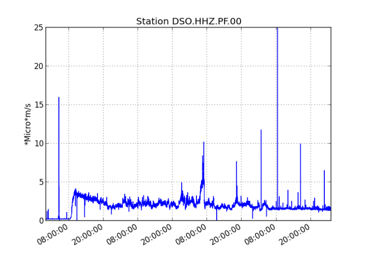
Figure 1: Evolution of the RSAM (volcanic tremor indicator) since 02/04/2020 at 00h UT time (04h local time) on the DSO seismological station located at the top of the volcano. (© OVPF / IPGP).
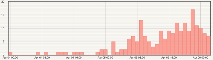
Figure 2: Histogram representing the number of surface volcano-tectonic earthquakes recorded since 4/4/2020 00 (UT time).
Strong seismicity is still recorded at Piton de La Fournaise. Since the day of 5/4/2020 00h (UT time): 189 superficial volcano-tectonic earthquakes (<2km deep) have been recorded under the summit craters (Figure 2). These earthquakes are still located under the south-eastern part of the Dolomieu crater (Figure 3).
These earthquakes testify to the weakening of the environment, either by a circulation of fluid or the emptying of a reservoir, most certainly in connection with the supply of the eruptive site and its renewed activity. Given this embrittlement, a risk of collapse of the Dolomieu crater (or part of the crater) is not excluded.
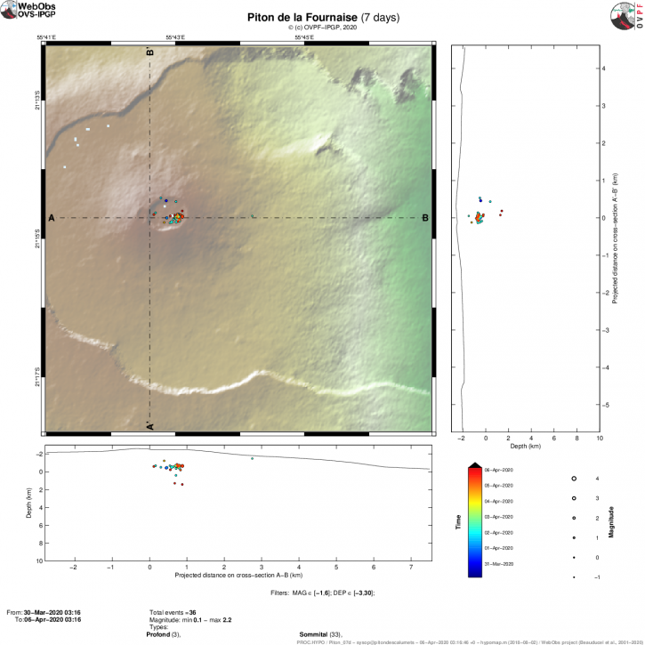
Figure 3: Location map (epicenters) and north-south and east-west sections (showing the location in depth, hypocenters) of earthquakes recorded and located by the OVPF-IPGP over the last 7 days under the Piton de la Fournaise. Only localizable earthquakes have been represented on the map. The observatory records seismic events not shown on this map because they cannot be located, due to their too low magnitude (© OVPF-IPGP).
The estimated surface flows, from satellite data via the HOTVOLC (OPGC – University of Auvergne) and MIROVA (University of Turin) platforms, although still greatly disturbed by the cloud cover around the Piton de la Fournaise, are still within the rise. Over the past 12 hours, average flows have been estimated at 30 m3 / s.
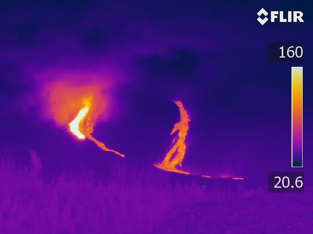
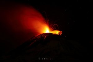
Figure 4: Shooting of the eruptive site on 5/4/2020 around 8pm local time from the RN2 (© OVPF-IPGP).
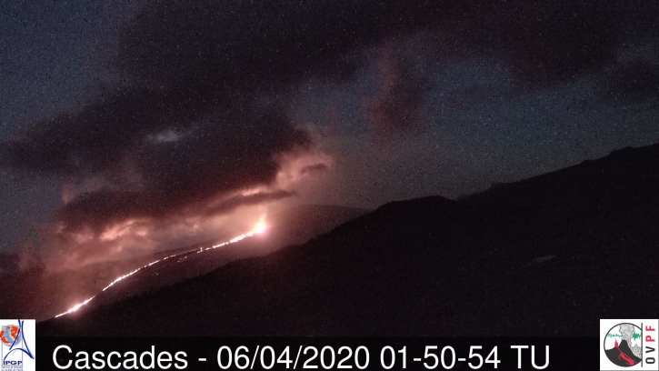
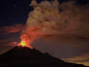
Figure 5: Shooting of the eruptive site on 6/4/2020 at 5:50 a.m. local time (1:50 a.m. UT) from the OVPF webcam located in Piton des Cascades (Sainte Rose) (© OVPF-IPGP).
Thermal images taken by an OVPF team yesterday evening and images from OVPF webcams last night show that the flow is still very active (Figures 4 and 5). Last night, the OVPF team on site reported the shutdown of the northernmost flow fronts, with activity focusing on a new flow arm to the south (Figure 4). The flow front on this new arm most certainly progressed last night. The Sainte Rose gendarmerie will go on site to regularly monitor its development, given the increase in lava flows.
A strong plume of gas, currently covers, the summit part of Piton de la Fournaise. SO2 peaks have been observed at OVPF stations located around the Enclos Fouqué, as well as by ORA in the Tampon and La Plaine des Cafres region. These SO2 peaks are linked to this revival of activity and to the wind which sheds the plume of gas linked to the eruption towards its sectors.
Pelé hair has also been reported in these regions. Pelé’s hair is formed when the lava projections emitted at the lava fountains are stretched and carried by the wind.
Given the high seismicity currently recorded in the summit area and the associated risks, the presence of a strong plume of gas in the summit area and bad weather conditions, the field mission planned by a team from the OVPF for the diagnosis and repair of a monitoring station damaged by the eruption is canceled.
* During this confinement period, the OVPF premises are closed but all of the OVPF and IPGP teams remain mobilized to monitor this crisis remotely by telework and rely on a dense network instrumentation (100 permanent sensors installed on the volcano) whose data arrive in real time on the observatory’s servers.
Source : OVPF .
Read the articles : http://www.ipgp.fr/fr/ovpf/bulletin-dactivite-dimanche-5-avril-2020-a-17h00-heure-locale
http://www.ipgp.fr/fr/ovpf/bulletin-dactivite-lundi-6-avril-2020-a-7h30-heure-locale
Photos : OVPF , SAG/PGHM .
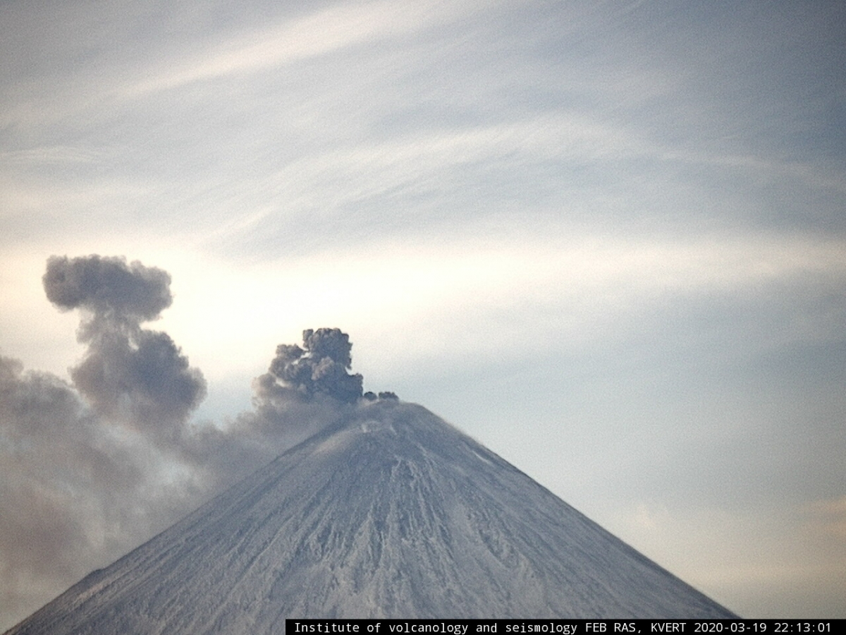
Kamchatka , Klyuchevskoy :
VOLCANO OBSERVATORY NOTICE FOR AVIATION (VONA).
Issued: April 05 , 2020.
Volcano: Klyuchevskoy (CAVW #300260)
Current aviation colour code: ORANGE
Previous aviation colour code: orange
Source: KVERT
Notice Number: 2020-38
Volcano Location: N 56 deg 3 min E 160 deg 38 min
Area: Kamchatka, Russia
Summit Elevation: 15580 ft (4750 m)
Volcanic Activity Summary:
A moderate explosive eruption of the Strombolian type of the volcano continues. According to video data, a gas-steam plume containing ash is extending about 20 km to the south-east from the volcano.
A moderate explosive eruption of the volcano continues. Ash explosions up to 16,400-23,000 ft (5-7 km) a.s.l. could occur at any time. Ongoing activity could affect low-flying aircraft.
Volcanic cloud height:
16400-18040 ft (5000-5500 m) AMSL Time and method of ash plume/cloud height determination: 20200405/2115Z – Video data
Other volcanic cloud information:
Distance of ash plume/cloud of the volcano: 12 mi (20 km)
Direction of drift of ash plume/cloud of the volcano: SE
Source : Kvert.
Photo : 19/3/2020 / IVS FEB RAS, KVERT
Indonesia , Kerinci :
VOLCANO OBSERVATORY NOTICE FOR AVIATION – VONA.
Issued: April 06 , 2020 .
Volcano: Kerinci (261170)
Current Aviation Colour Code: YELLOW
Previous Aviation Colour Code: yellow
Source: Kerinci Volcano Observatory
Notice Number: 2020KER14
Volcano Location: S 01 deg 41 min 49 sec E 101 deg 15 min 50 sec
Area: Jambi, West Sumatra, Indonesia
Summit Elevation: 12176 FT (3805 M)
Volcanic Activity Summary:
On 6 April 2020, observed brown ash emission at 01:54 UTC ( 08:54 Local Time ).
Volcanic Cloud Height:
Best estimate of ash-cloud top is around 13776 FT (4305 M) above sea level, may be higher than what can be observed clearly. Source of height data: ground observer.
Other Volcanic Cloud Information:
Ash emission moving North-Northwest.
Remarks:
Seismic activity is dominated by gas emission and continuous volcanic tremor with amplitude 0,5-1 mm (dominan 1mm).
Source : Magma Indonésie.
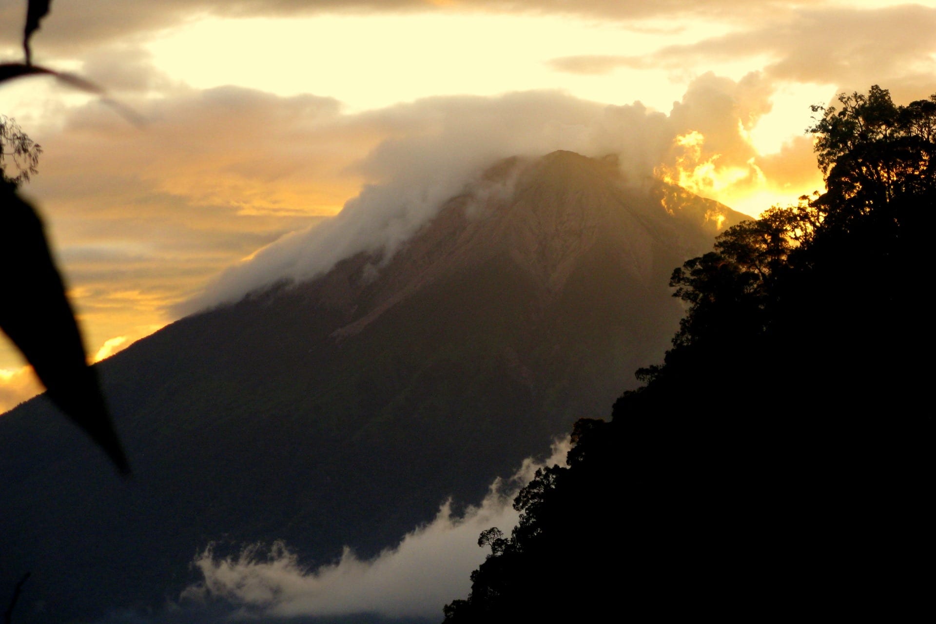
Photo : Wild Sumatra.
Chile , Nevados de Chillan :
Chile: An explosion was recorded on the Nevados de Chillán volcano.
SERNAGEOMIN reports that an explosion was recorded on the Nevados de Chillán volcano in central southern Chile.
This one had a column height of 1000 m above the active crater with South-East direction, characterized by the presence of particulate matter. The yellow technical alert remains.
We report that an explosion with a column height of 1000 m was recorded on the active crater with a southeast direction, characterized by the presence of particulate matter. The YELLOW technical alert remains.
Source : Sernageomin , noticiasnqn.com.ar .
Guatemala , Fuego :
Type of activity: Vulcanian
Morphology: composite stratovolcano
Location: 14 ° 28’54˝ Latitude N; 90 ° 52’54˝ Longitude W
Height: 3763msnm
Atmospheric conditions: Clear
Wind: East at 3 km / h
Precipitation: 24.0 mm.
Activity:
Presence of white / blue degassing fumaroles at an altitude of 4300 m moving towards the South. 8 to 12 low to moderate explosions are generated per hour which expel columns of gray ash at a height of 4,500 to 4,700 m above sea level (14,765- 15,420 feet) which are dispersed over 8 to 15 km east and south -East. Incandescent pulses were observed at 100 – 200 m altitude at night and early in the morning with weak to moderate avalanches around the crater, mainly in the Canyons Seca, Taniluya, Ceniza, Trinidad and Las Lajas. Weak, moderate and some loud rumblings are perceived which cause weak shock waves perceptible at 25 km distance, as well as sounds similar to those of train locomotives with intervals of 1 to 3 minutes. There are falls of fine particles of ash at Panimache I, Rochela, Ceylon, Osuna and others.
Source : Insivumeh .
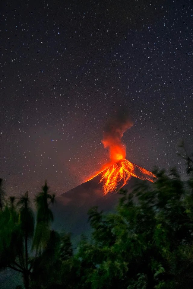
Photo : Massoud Ufo Jorge