Marcu 13 , 2022.
Hawaii , Kilauea :
19°25’16 » N 155°17’13 » W,
Summit Elevation 4091 ft (1247 m)
Current Volcano Alert Level: WATCH
Current Aviation Color Code: ORANGE
Activity Summary:
The summit eruption of Kīlauea Volcano, within Halemaʻumaʻu crater, continued over the past 24 hr. All recent activity has been confined to the smaller active lake within the crater, and there are no indications of activity migrating elsewhere on Kīlauea.
Halemaʻumaʻu Lava Lake Observations:
Eruption of lava from the western vent into the active lava lake surface (approximately 2.5% of Halemaʻumaʻu crater floor) continued through yesterday. The active western lava lake surface of Halema‘uma‘u crater has remained at a steady elevation over the past 24 hours, corresponding with slightly deflationary tilt for the past three days. The highest point on the Halemaʻumaʻu crater floor has risen approximately 97 meters (318 feet) since the eruption began on September 29, 2021.
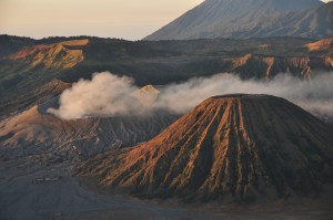
This aerial photo, taken south of Halema‘uma‘u crater, shows the active part of the eruption at Kīlauea summit during a routine Hawaiian Volcano Observatory monitoring overflight on March 2, 2022. Though the bottom of Halema‘uma‘u crater is paved by lava erupted since this eruption began on September 29, 2021, recent activity has usually remained within the west portion of the the crater, in the vicinity of the west vent.
Summit Observations:
Summit tilt yesterday continued a slightly deflationary trend through yesterday. Seismic data shows that the volcanic tremor is still elevated this morning and earthquake activity at the summit remains below background levels. A sulfur dioxide (SO2) emission rate of approximately 1900 tonnes per day (t/d) was measured on March 10.
Source : HVO.
Photo : USGS / K. Mulliken.
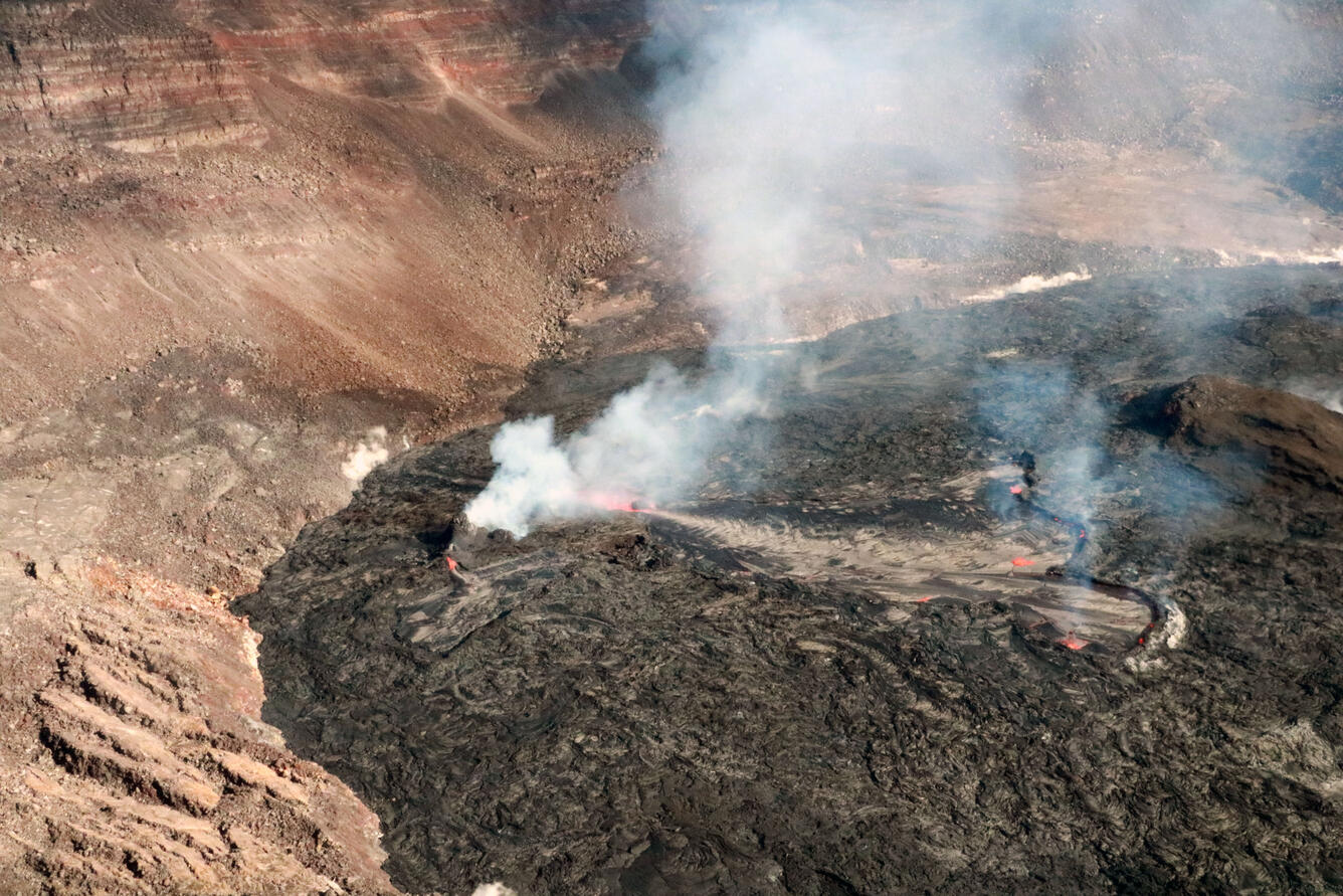
Alaska , Pavlof :
55°25’2″ N 161°53’37 » W,
Summit Elevation 8261 ft (2518 m)
Current Volcano Alert Level: WATCH
Current Aviation Color Code: ORANGE
Low-level eruption continues. Small explosions continued over the past day and were detected in local seismic and infrasound data. Web camera observations were obscured by clouds, but it is likely that these explosions produced small ash clouds that dispersed in the immediate vicinity of the active east vent near the summit. Moderate intensity seismic tremor continues. Elevated surface temperatures were observed in the satellite images over the past day, consistent with continued activity from the east flank vent near the summit.
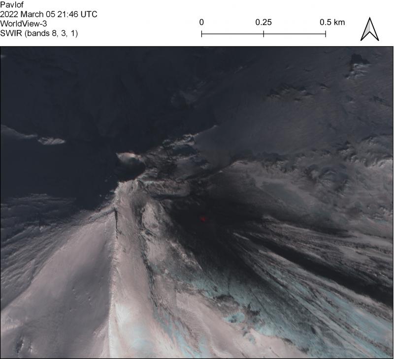
Near-IR false color WorldView-3 satellite image on March 5 at Pavlof. No active lava flows are visible but the active east vent is hot (near-IR red) and ballistic impacts are visible in the snow around this vent. Only steaming is visible from the north vent.
The small explosions associated with this eruption could happen at any time and may be accompanied by small ash plumes within the immediate vicinity of the volcano. The level of unrest at Pavlof can change quickly and the progression to more significant eruptive activity can occur with little or no warning.
Pavlof is monitored by local seismic and infrasound sensors, satellite data, web cameras, and remote infrasound and lightning networks.
Source : AVO
Photo : Loewen, M. W.
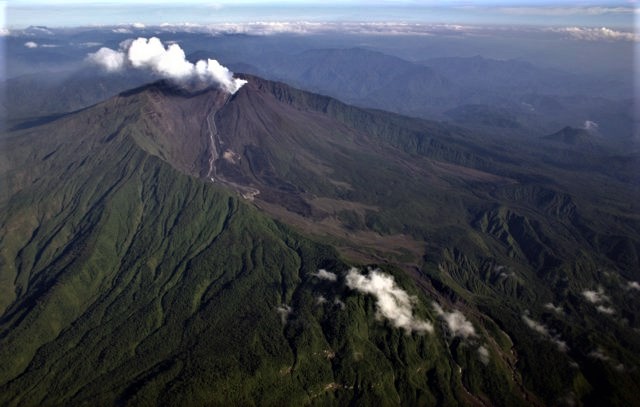
Indonesia , Semeru :
VOLCANO OBSERVATORY NOTICE FOR AVIATION – VONA
Issued : March 13 , 2022
Volcano : Semeru (263300)
Current Aviation Colour Code : ORANGE
Previous Aviation Colour Code : orange
Source : Semeru Volcano Observatory
Notice Number : 2022SMR59
Volcano Location : S 08 deg 06 min 29 sec E 112 deg 55 min 12 sec
Area : East java, Indonesia
Summit Elevation : 11763 FT (3676 M)
Volcanic Activity Summary :
Eruption with volcanic ash cloud at 01h12 UTC (08h12 local)
Volcanic Cloud Height :
Best estimate of ash-cloud top is around 14003 FT (4376 M) above sea level, may be higher than what can be observed clearly. Source of height data: ground observer.
Other Volcanic Cloud Information :
Ash-cloud moving to southwest
Earthquakes are related to magma and tectonic activity. It was recorded:
– 35 earthquakes of eruptions/explosions
– 1 avalanche earthquake
– 11 emission earthquakes
– 5 distant tectonic earthquakes
Sources : Magma Indonésie , PVMBG.
Photo : Oystein lund Andersen .
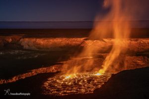
Ecuador , Sangay / Reventador / Wolf :
DAILY REPORT OF THE STATE OF SANGAY VOLCANO, Saturday March 12, 2022.
Information Geophysical Institute – EPN.
Surface Activity Level: High, Surface Trend: No change.
Internal activity level: High, Internal trend: No change.
Seismicity: From March 11, 2022, 11:00 a.m. to March 12, 2022, 11:00 a.m.:
Explosion (EXP) 25
Long Periods (LP) 31
Emission Tremors (TREMI) 2
Rains / Lahars:
Thanks to the Windy satellite system, it was possible to verify the possible occurrence of rains in the volcano area. **In the event of heavy rains, these could remobilize the accumulated materials, generating mudslides and debris that would descend on the flanks of the volcano and flow into the adjacent rivers.**

Emission / ash column:
In the morning, an emission with low ash content and direction North-East was observed, up to about 1000 meters above the level of the crater. 4 VAAC alerts were recorded up to 870 meters above crater level with a direction between North-East and North-West.
Gas:
In the MOUNTS system, 873 tons of SO2 were recorded, with data from March 11.
Other Monitoring Parameters:
The MIROVA system recorded 2 moderate thermal alerts (42 MW and 90 MW). The FIRMS system recorded 57 thermal alerts over the past 24 hours.
Observation:
The weather conditions are permanently cloudy.
Alert level: Orange.
——————————————————————————————
DAILY REPORT OF THE STATE OF THE REVENTADOR VOLCANO, Saturday March 12, 2022.
Information Geophysical Institute – EPN.
Surface Activity Level: High, Surface Trend: No change.
Internal activity level: Moderate, Internal trend: No change.
Seismicity: From March 11, 2022, 11:00 a.m. to March 12, 2022, 11:00 a.m.:
Explosion (EXP) 20
Long Periods (LP) 52
Emission Tremors (TREMI) 16
Harmonic tremor (TRARM): 2
Rains / Lahars:
The forecast from the Windy satellite system showed the possible occurrence of light rain in the area.
Gas:
In the MOUNTS system, 1373.1 tonnes of SO2 were recorded, with data from March 11.
Emission / ash column:
Ash emissions were observed with heights greater than 1000 meters above the level of the crater, and directions oscillating between north and west. Similarly, a VAAC alert of 988 meters above crater level was recorded, heading northwest.
Other Monitoring Parameters:
No thermal alerts have been recorded in the last 24 hours.
Observation:
During the afternoon of yesterday, several emissions were observed, already described above.
Alert level: Orange.
——————————————————————————————————————
DAILY REPORT OF THE STATE OF WOLF VOLCANO. Saturday March 12, 2022.
Surface Activity Level: High, Surface Trend: Unchanged
Internal activity level: High, Internal trend: No change
Seismicity: From March 11, 2022, 11:00 a.m. to March 12, 2022, 11:00 a.m.:
Volcano tectonics ( VT) 1
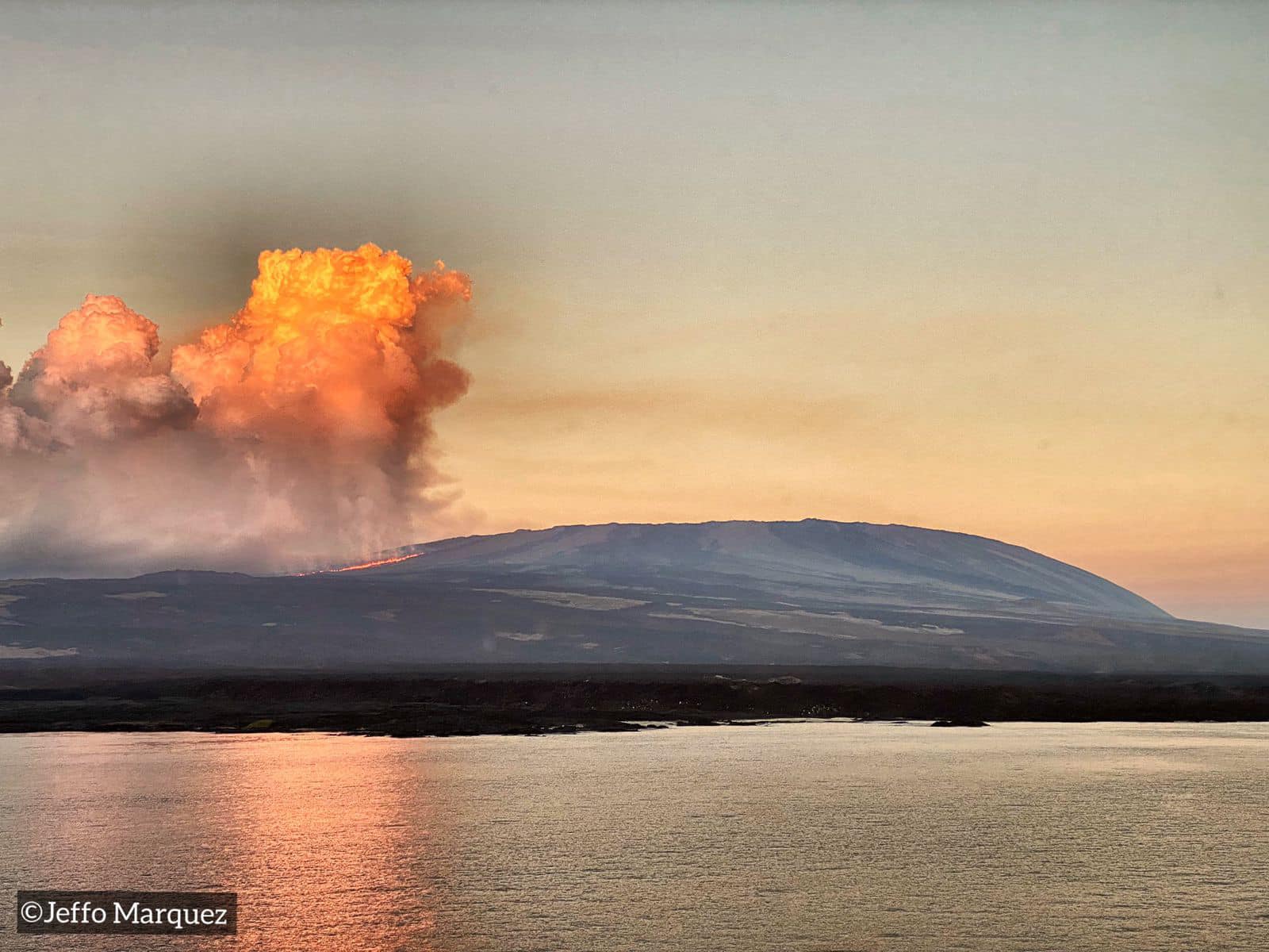
Other Monitoring Parameters:
The FIRMS system recorded 159 thermal alerts. The MIROVA system recorded 2 high thermal alerts (889 MW and 606 MW).
Observation:
Thanks to the images provided by the GOES-16 satellite, the thermal anomalies caused by the advance of the lava flows can be seen
Alert level: Without alert.
Source : IGEPN.
Photos : Igepn , Patricio Ramon, 2005 (Instituto Geofisca, Escuela Politecnica Nacional), Jeffo Marquez.
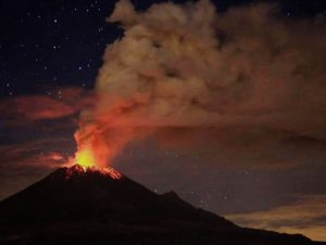
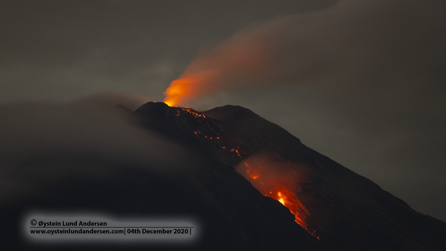
Guatemala , Fuego :
SPECIAL VOLCANOLOGICAL BULLETIN. UPDATE ON VOLCANIC ACTIVITY.
Following what is described in the BEFGO bulletin n° 014-2022 and on the basis of instrumental parameters and field monitoring, degassing is recorded in the crater of the Fuego volcano at an altitude of 4300 m above sea level, with explosions with weak, moderate and strong characteristics with abundant emissions of gas and ash which disperse towards the West and the South-West. These explosions also generate weak to moderate avalanches towards the ravines of the volcano, in particular towards the ravines of Ceniza, Trinidad and Las Lajas. Due to this activity, tephra falls are reported in the communities of Morelia, Panimaché I, Panimaché II.

Ash can be blown away and remain suspended at low levels in the air, creating a hazy environment for several hours, which can be detrimental to human health. In the presence of rain, lahars can be generated in all the ravines of the volcano, however, these should be more recurrent and larger in the ravines of El Jute, Las Lajas, Ceniza and Trinidad.
It is not excluded that new lava flows will be generated towards other ravines, as well as the continuation of violent explosions loaded with ash and avalanches of moderate characteristics towards one of the ravines of the Fuego volcano, reason for which one should not stay near or in the canyons of the volcano.
Source : Insivumeh.
Photo : Conred.