March 11 , 2022.
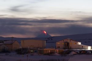
Alaska , Semisopochnoi :
51°55’44 » N 179°35’52 » E,
Summit Elevation 2625 ft (800 m)
Current Volcano Alert Level: WATCH
Current Aviation Color Code: ORANGE
Seismic tremor continues and two moderate-sized explosions were detected on the regional infrasound network over the past day. Web camera and satellite observations were obscured by clouds, but it is likely that these explosions resulted in ash emissions from the north crater of Mount Cerberus.
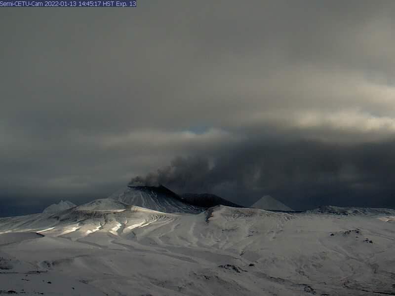
Small eruptions producing minor ash deposits within the vicinity of the active north crater of Mount Cerberus and ash clouds usually under 10,000 ft (3 km) above sea level have characterized the recent activity. Small explosions and associated ash emissions may continue and could be difficult to detect, especially when thick cloud cover obscures the volcano.
Semisopochnoi is monitored by local seismic and infrasound sensors, satellite data, web cameras, and remote infrasound and lightning networks.
Source : AVO
Photo : Alaska Volcano Observatory / U.S. Geological Survey.
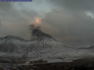
Indonesia , Ibu :
VOLCANO OBSERVATORY NOTICE FOR AVIATION – VONA
Issued : march 10 , 2022
Volcano : Ibu (268030)
Current Aviation Colour Code : ORANGE
Previous Aviation Colour Code : orange
Source : Ibu Volcano Observatory
Notice Number : 2022IBU11
Volcano Location : N 01 deg 29 min 17 sec E 127 deg 37 min 48 sec
Area : North Maluku, Indonesia
Summit Elevation : 4240 FT (1325 M)
Volcanic Activity Summary :
Eruption with volcanic ash cloud at 01h27 UTC (10h27 local).
Volcanic Cloud Height :
Best estimate of ash-cloud top is around 7440 FT (2325 M) above sea level, may be higher than what can be observed clearly. Source of height data: ground observer.
Other Volcanic Cloud Information :
Ash-cloud moving to east.
Remarks :
Eruption and ash emission is continuing.
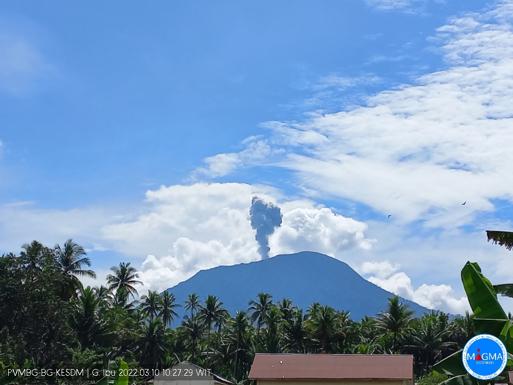
The volcano was clearly visible until it was covered in fog. Smoke from the crater is white/gray with low intensity, thick, about 200-400 meters above the summit. The weather is sunny to rainy, the wind is light to moderate in the North and North-East.
Earthquakes related to magma and tectonic activity. It was recorded:
– 42 earthquakes of eruptions/explosions
– 81 avalanche earthquakes
– 13 emission earthquakes
– 45 harmonic tremors
– 41 shallow volcanic earthquakes
– 3 deep volcanic earthquakes
– 4 distant tectonic earthquakes.
Sources : Magma Indonésie , PVMBG.
Photo : Magma Indonésie.
Hawaii , Kilauea :
19°25’16 » N 155°17’13 » W,
Summit Elevation 4091 ft (1247 m)
Current Volcano Alert Level: WATCH
Current Aviation Color Code: ORANGE
Activity Summary:
The summit eruption of Kīlauea Volcano, within Halemaʻumaʻu crater, continued over the past 24 hr. All recent activity has been confined to the smaller active lake within the crater, and there are no indications of activity migrating elsewhere on Kīlauea.
Bursts of lava erupting from a vent in the western half of Halema‘uma‘u crater, at Kīlauea volcano summit, were reaching 15-20 meters (50-65 feet) from the top of the cone on March 4, 2022. A small channel of sluggish lava was flowing down the western side of this cone. The other cones located in this area were 15 (50 feet) and 9 meters (30 feet) in height on March 4, 2022.
Halemaʻumaʻu Lava Lake Observations:
Eruption of lava from the western vent into the active lava lake surface (approximately 2.5% of Halemaʻumaʻu crater floor) continued through yesterday. The active western lava lake surface of Halema‘uma‘u crater has remained at a steady elevation over the past 24 hours, corresponding with slightly deflationary tilt yesterday. The highest point on the Halemaʻumaʻu crater floor has risen approximately 97 meters (318 feet) since the eruption began on September 29, 2021. The erupted volume is 45 million cubic meters (59 million cubic yards) of lava as measured on January 25, 2021.
Summit Observations:
Summit tilt yesterday was flat, becoming slightly deflationary overnight. Slight deflationary tilt continues at this time. Seismic data shows that the volcanic tremor is still elevated this morning and earthquake activity at the summit remains below background levels. A sulfur dioxide (SO2) emission rate of approximately 2200 tonnes per day (t/d) was measured on March 8.
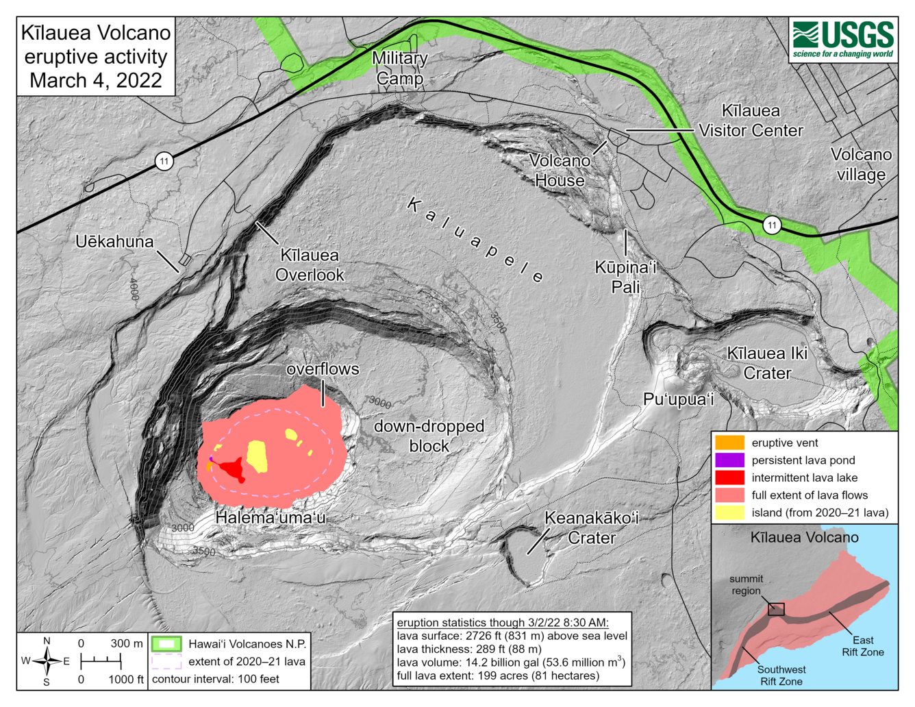
This reference map depicts the ongoing Kīlauea summit eruption on March 4, 2022. One eruptive vent is intermittently active within Halema‘uma‘u, in the western end of the crater. When this vent is effusing lava, it pours into a lava lake, colored red on this map. During eruptive pauses, the only active lava is within a pond just north of the vent, colored dark purple on this map. The eruption statistics provided here are current as of the last HVO overflight on March 2, 2022; the volume-averaged surface of the whole lava lake was approximately 2,726 ft (831 m) above sea level at that time. When the eruption is vigorous, lava is visible from three public visitor overlooks in Hawai‘i Volcanoes National Park: Keanakāko‘i Overlook and KUPINAI Pali (Waldron Ledge) can see the eruptive vent and lava lake, while Kīlauea Overlook can occasionally see lava ooze-outs in the southeast part of the crater.
Rift Zone Observations:
No unusual activity has been noted along the East Rift Zone or Southwest Rift Zone; low rates of ground deformation and seismicity continue along both. Measurements from continuous gas monitoring stations downwind of Puʻuʻōʻō in the middle East Rift Zone remain below detection limits for SO2, indicating that SO2 emissions from Puʻuʻōʻō are negligible.
Source : HVO.
Photos : USGS / L. Gallant.
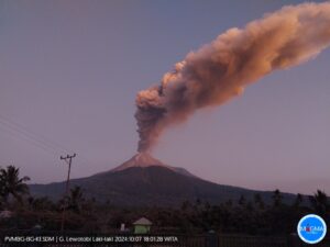
Guatemala , Santiaguito / Fuego :
Activity of the Santiaguito volcano:
The Santiaguito volcano observatory reports degassing which, due to the configuration of the winds, is dispersed towards the West and the South-West. At night, incandescence was observed in the crater of the Caliente dome and in the lava flows in the west and south-west directions. Weak to moderate boulder and ash avalanches continue to be recorded on the West and Southwest flanks, these avalanches reaching the base of the Caliente dome.
At the front of the flow, a detachment of blocks is generated which generates ash emissions into the environment. The volcano maintains high activity due to extrusion of blocky lava into the Caliente dome in a west-southwest direction and unstable material within the crater. There is a likelihood of moderate to strong pyroclastic flows, so do not stay near or in the ravine beds near the slopes of the volcano. The recommendations of BESAN bulletin n° 003-2022 are still valid.
Activity of the Fuego volcano:
The Fuego volcano observatory reports a column of ash 4,700 to 5,000 meters above sea level (15,420 to 16,404 feet) which is scattered to the west and southwest. 1 to 4 weak and a few moderate rumblings were heard per hour, with moderate to strong shock waves rattling the roofs and windows of houses around the volcano. The descent of moderate to strong avalanches in the direction of the ravines of Ceniza, Trinidad, Santa Teresa and Las Lajas is recorded, generating materials that reach the edge of the vegetation.

Weak ash falls are reported in Panimaché I, Panimaché II, Morelia, Santa Sofia, El Porvenir, Sangre de Cristo, Yepocapa, among others. The recommendations of BEFGO bulletin n°014-2022 are still relevant since high temperature material deposited by the descent of pyroclastic flows from the recent eruption persists.
Source : Insivumeh.
Photos : Noticias Caballo Blanco, Diego Rizzo .
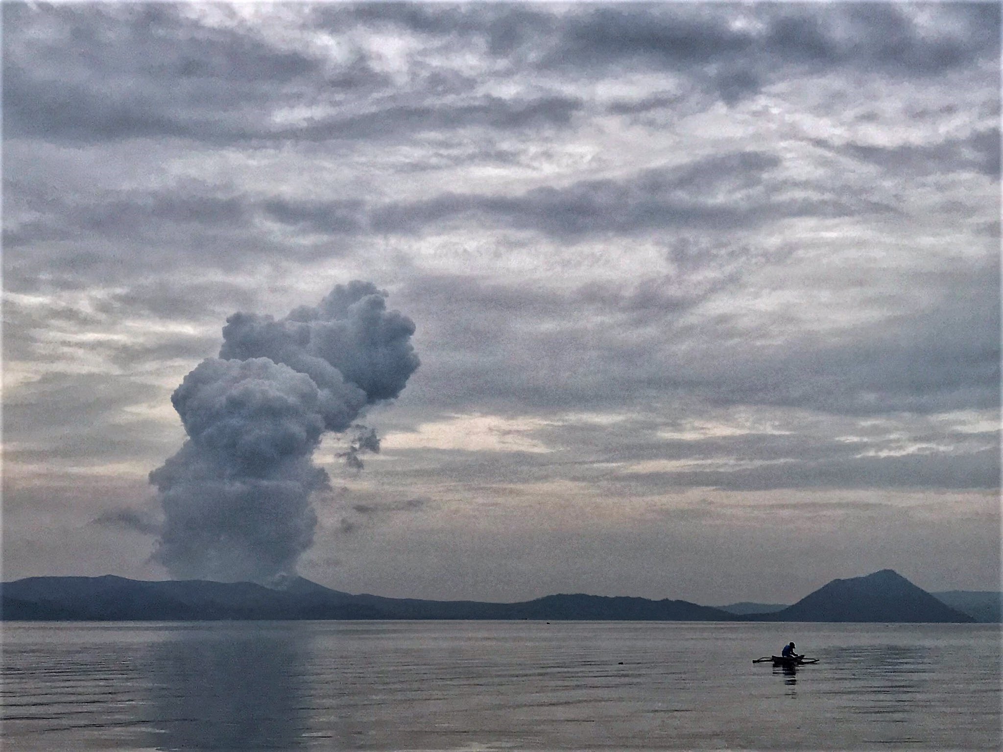
Philippines , Taal :
TAAL VOLCANO BULLETIN 11 March 2022 8:00 AM
In the past 24-hour period, the Taal Volcano Network recorded eight (8) volcanic earthquakes, including four (4) volcanic tremor events having durations of two (2) to eight (8) minutes, and three (3) low-frequency volcanic earthquakes. Activity at the Main Crater was dominated by upwelling of hot volcanic fluids in its lake which generated plumes 1,200 meters tall that drifted southwest. Sulfur dioxide (SO2) emission averaged 15,990 tonnes/day on 09 March 2022. Temperature highs of 63.7°C were last measured from the Main Crater Lake on 25 February 2022. Based on ground deformation parameters from electronic tilt, continuous GPS and InSAR monitoring, Taal Volcano Island and the Taal region has begun deflating in October 2021.
Alert Level 2 (Increased Unrest) prevails over Taal Volcano. DOST-PHIVOLCS reminds the public that at Alert Level 2, sudden steam- or gas-driven explosions, volcanic earthquakes, minor ashfall, and lethal accumulations or expulsions of volcanic gas can occur and threaten areas within and around TVI. DOST-PHIVOLCS strongly recommends that entry into Taal Volcano Island, Taal’s Permanent Danger Zone or PDZ must be strictly prohibited, especially the vicinities of the Main Crater and the Daang Kastila fissure, and extended stays on Taal Lake.
Source : Phivolcs.
Photo : Rizal M