February 11 , 2022.
Italy / Sicily , Etna :
Statement on ETNA activity, February 10, 2022, 16:02, (15:02 UTC):
The National Institute of Geophysics and Volcanology, Osservatorio Etneo announces that from 14:20 UTC from the cameras of the video surveillance network, a modest overflow of lava is observed from the Southeast Crater, which flows in a westerly direction – South West.
From the seismic point of view, the phase of increase in the average amplitude of the volcanic tremor continued, which reached the base of the high level around 13:30 UTC. The sources of the tremor remain in the area of the Southeast Crater, at an altitude of approximately 2800 m above sea level. Infrasound activity showed a further increase in the rate of occurrence of events and their magnitude. The infrasonic events are located at the level of the Southeast Crater.
Soil deformation monitoring networks show no significant variations.
February 10, 2022, 19:56 (18:56 UTC):
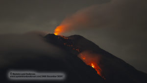
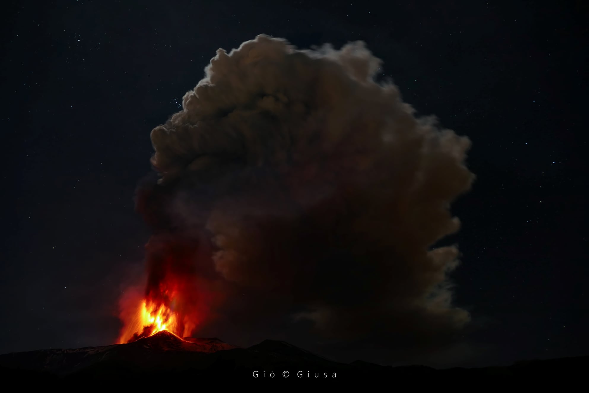
From about 4:00 p.m. UTC, there was, through alternating phases in terms of intensity and frequency, a decisive intensification of Strombolian activity at the level of the Southeast Crater, described in the update press release. day 534. Based on the forecast model, the volcanic plume is heading west. The lava flow produced by the ongoing activity at the Southeast Crater seems to be still fed and the front has reached an estimated altitude of about 2900 m above sea level.
The phase of increase in the average amplitude of the volcanic tremor continued, which reached a high level with an oscillatory trend. The sources of the tremor remain in the area of the Southeast Crater, at an altitude of about 2800-2900 m above sea level. The infrasound activity also showed an upward trend, characterized by fluctuations marked with the rate of occurrence of events and their amplitude values ranging from medium to high. Infrasonic events are mainly located at the Southeast Crater.
There are no significant changes in the time series of the ground deformation monitoring networks.
February 10, 2022, 21:59 (20:59 UTC):
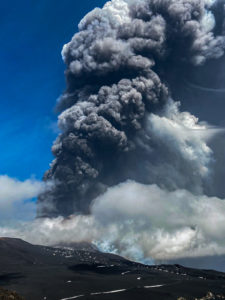
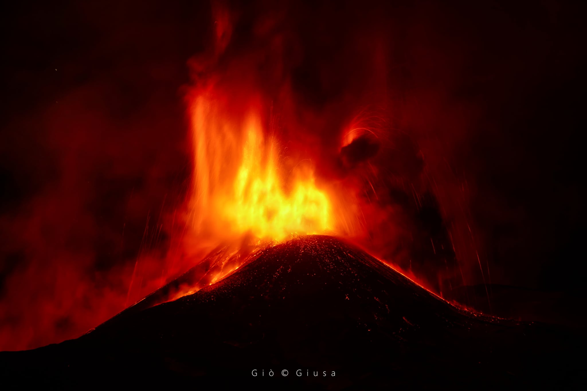
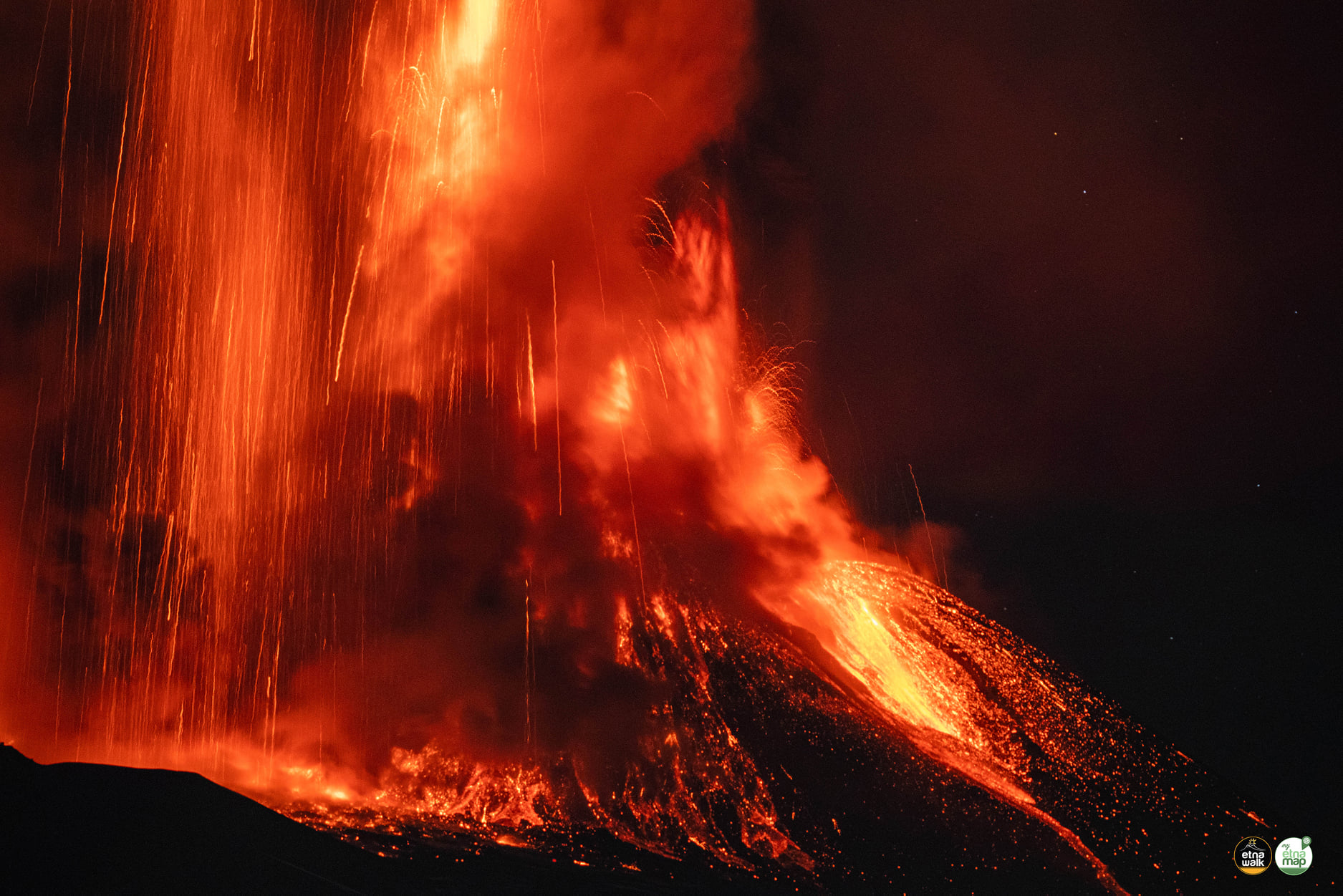
From about 20:40 UTC, the transition from Strombolian activity to the lava fountain stage at the Southeast Crater is observed. The lava flow produced by the activity at the Southeast Crater continues to be well fed. The eruptive cloud produced by the current activity, about 10000 m high, disperses in the western sector of the volcano.
The average amplitude of the volcanic tremor has reached very high values and the sources remain in the area of the Southeast Crater, at an altitude of about 2900-3000 m above sea level. The infrasonic activity has also reached very high values and is located in the Southeast Crater.
The GNSS ground deformation monitoring network shows no significant changes.
February 10, 2022, 22:41 (21:41 UTC):
At 8:40 p.m., 9:19 p.m. and 9:26 p.m. UTC, there were three flows of pyroclastic material from the Southeast Crater. The first two flows traveled a few hundred meters towards the Valle del Bove while the third flow also heads south covering a few hundred meters.
Further updates will be communicated soon.
February 10, 2022, 00:19 (23:19 UTC):
Southeast Crater lava fountaining has ceased. The eruptive cloud produced by the activity, at about 8000 meters above sea level, disperses in the western sector of the volcano. The lava flow produced by the current activity at the Southeast Crater seems still fed and the front is at an altitude of about 2700 m.
The average amplitude of the volcanic tremor, after reaching the maximum value at 21:00 UTC, underwent a rapid decrease, returning to the average level.
Currently, this parameter shows a trend of further decrease. The center of gravity of the sources of volcanic tremors remains localized in the area of the Southeast Crater at an altitude of approximately 2900 m above sea level. At the same time, the infrasonic activity has also undergone a decrease rapid in both the number of events and the amplitude.
The tilt network showed variations within a few microradians during lava fountaining activity. On the other hand, no significant change was observed in the time series of the GNSS network.
Source : INGV.
Photos : Gio Giusa , Giuseppe Distefano / Marco Restivo , Gio Giusa .
Philippines , Taal :
TAAL VOLCANO BULLETIN 11 February 2022 8:00 AM
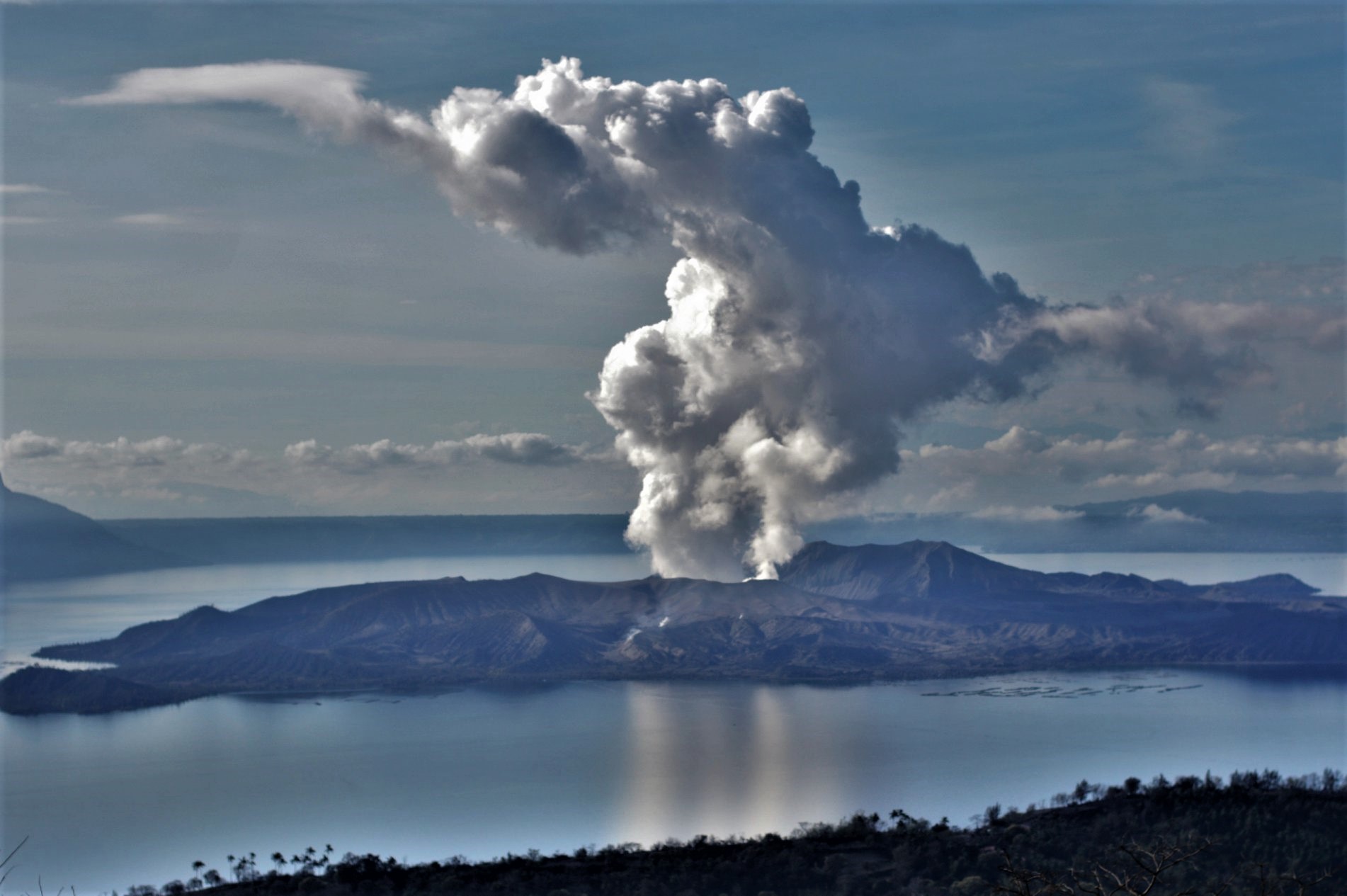
In the past 24-hour period, the Taal Volcano Network recorded seven (7) volcanic earthquakes, including two (2) volcanic tremor events, five (5) low-frequency volcanic earthquakes and low-level background tremor has persisted since July 7, 2021. One short-lived phreatomagmatic burst was recorded at 4:16 PM yesterday based on seismic records and visual cameras. This event produced plume 300 meters tall that drifted southwest inside the Main Crater. Activity at the Main Crater was dominated by upwelling of hot volcanic fluids in its lake which generated plumes 1500 meters tall that drifted southwest. Sulfur dioxide (SO2) emission averaged 10,009 tonnes/day on 10 February 2022. Based on ground deformation parameters from electronic tilt, continuous GPS and InSAR monitoring, Taal Volcano Island and the Taal region has begun deflating in October 2021.
Alert Level 2 (Increased Unrest) prevails over Taal Volcano. DOST-PHIVOLCS reminds the public that at Alert Level 2, sudden steam- or gas-driven explosions, volcanic earthquakes, minor ashfall, and lethal accumulations or expulsions of volcanic gas can occur and threaten areas within and around TVI. DOST-PHIVOLCS strongly recommends that entry into Taal Volcano Island, Taal’s Permanent Danger Zone or PDZ must be strictly prohibited, especially the vicinities of the Main Crater and the Daang Kastila fissure, and extended stays on Taal Lake.
Source : Phivolcs
Photo : Richard Langford.
Indonesia , Semeru :
VOLCANO OBSERVATORY NOTICE FOR AVIATION – VONA
Issued : February 11 , 2022
Volcano : Semeru (263300)
Current Aviation Colour Code : ORANGE
Previous Aviation Colour Code : orange
Source : Semeru Volcano Observatory
Notice Number : 2022SMR25
Volcano Location : S 08 deg 06 min 29 sec E 112 deg 55 min 12 sec
Area : East java, Indonesia
Summit Elevation : 11763 FT (3676 M)
Volcanic Activity Summary :
Eruption with volcanic ash cloud at 00h25 UTC (07h25 local).
Volcanic Cloud Height :
Best estimate of ash-cloud top is around 13363 FT (4176 M) above sea level, may be higher than what can be observed clearly. Source of height data: ground observer.
Other Volcanic Cloud Information :
Ash-cloud moving to north
Remarks : Seismic activity is characterized by eruption, avalanche and gas emission earthquakes

The volcano is clearly visible until it is covered in fog. White smoke from the main crater was observed with a high thickness, about 50-100 meters above the summit. The weather is sunny to rainy, the wind is light to moderate in the North, North-East and West. The air temperature is around 21-26°C. An eruption was observed with grey/white smoke, rising 50-100 meters above the summit.
Earthquakes are related to magma, tectonic activity and flooding. It was recorded:
– 60 earthquakes of eruptions/explosions
– 1 avalanche earthquake
– 13 emission earthquakes
– 12 harmonic tremors
– 1 deep volcanic earthquake
– 3 distant tectonic earthquakes
Source : Magma Indonésie , PVMBG.
Photo : Oystein Lund Andersen .
Guatemala , Fuego :
Activity:
5 to 8 weak and moderate explosions are generated per hour. These generate gas and ash plumes 4,500 to 4,800 m a.s.l. (14,763 to 15,748 ft) that extend 10 to 15 km to the east and northeast. The explosions are accompanied by avalanches, mostly moderate to strong, generating material in the ravines that reach the edge of the vegetation. Low, moderate and loud rumblings were recorded, with low to moderate shock waves, which vibrate the roofs and windows of houses around the volcano. Slight sounds similar to those of a train engine were heard for 1 to 3 minutes.
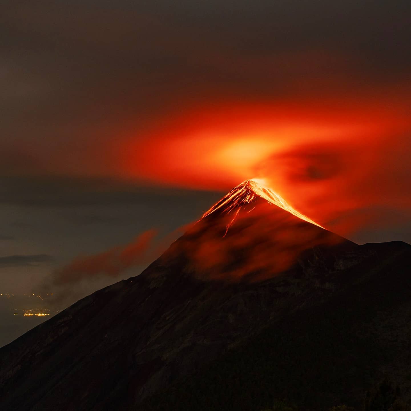
During the night and early in the morning, incandescent pulses from 100 to 300 meters above sea level are observed above the crater as well as active lava flow activity 100 meters long in the direction of the Ceniza ravine. Due to wind direction, fine ash may fall in Alotenango, Ciudad Vieja, San Miguel Dueñas, Antigua Guatemala and others in that direction. Similarly, the rumblings generated by the explosions could be perceptible by the population located northeast of the volcanic complex, especially at night and early in the morning.
Source : Insivumeh.
Photo : Diego Rizzo .
Alaska , Pavlof :
55°25’2″ N 161°53’37 » W,
Summit Elevation 8261 ft (2518 m)
Current Volcano Alert Level: WATCH
Current Aviation Color Code: ORANGE
Low-level eruptive activity continues at Pavlof Volcano. Elevated surface temperatures, suggestive of lava effusion, were observed in satellite images throughout the past day. Seismicity remains elevated with continuous tremor – also consistent with continued effusive activity. No explosive activity was recorded.
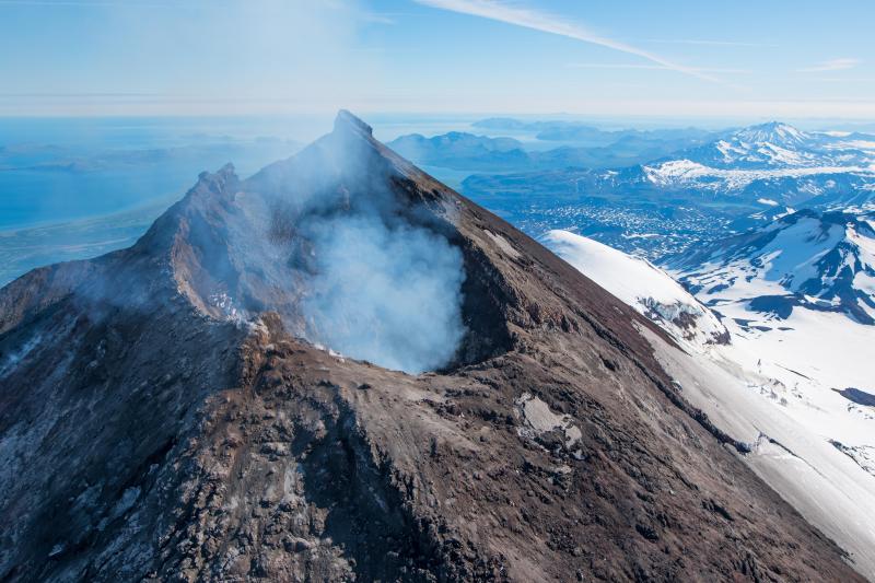
Small explosions accompanied by low-level ash emissions could happen at any time, and are typically a hazard in the immediate vicinity of the summit. The level of unrest at Pavlof can change quickly and the progression to more significant eruptive activity can occur with little or no warning.
Pavlof is monitored by local seismic and infrasound sensors, satellite data, web cameras, and remote infrasound and lightning networks.
Source : AVO.
Photo : Waythomas, Chris / Alaska Volcano Observatory / U.S. Geological Survey( 2017).