February 06 , 2022.
Indonesia , Anak Krakatau :
VOLCANO OBSERVATORY NOTICE FOR AVIATION – VONA
Issued : February 06 2022
Volcano : Anak Krakatau (262000)
Current Aviation Colour Code : ORANGE
Previous Aviation Colour Code : orange
Source : Anak Krakatau Volcano Observatory
Notice Number : 2022KRA12
Volcano Location : S 06 deg 06 min 07 sec E 105 deg 25 min 23 sec
Area : Lampung, Indonesia
Summit Elevation : 502 FT (157 M)
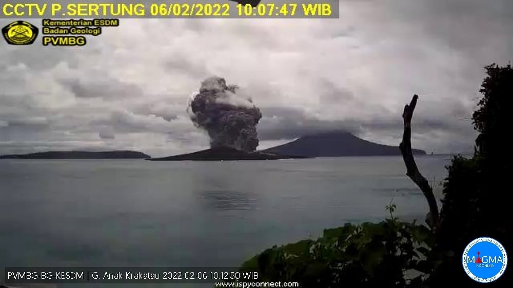
Volcanic Activity Summary :
– Eruption with volcanic ash cloud at 00:03 UTC (07:03 local)
– Eruption with ash clouds at 03:05 UTC (10:05 local time). The eruption lasted for 223 seconds.
Volcanic Cloud Height :
Best estimate of ash-cloud top is around 5302 FT (1657 M) above sea level, may be higher than what can be observed clearly. Source of height data: ground observer.
Other Volcanic Cloud Information :
Visuals directly from the cctv were observed eruptions with the color of the thick black eruption smoke 1500m from the top of the volcano, the wind direction quickly to the east.
Remarks :
Eruption recorded on seismogram with maximum amplitude 56 mm and maximum duration 223 second.
Source : MAGMA INDONESIE, PVMBG.
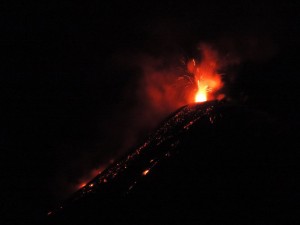
Alaska , Pavlof :
55°25’2″ N 161°53’37 » W,
Summit Elevation 8261 ft (2518 m)
Current Volcano Alert Level: WATCH
Current Aviation Color Code: ORANGE
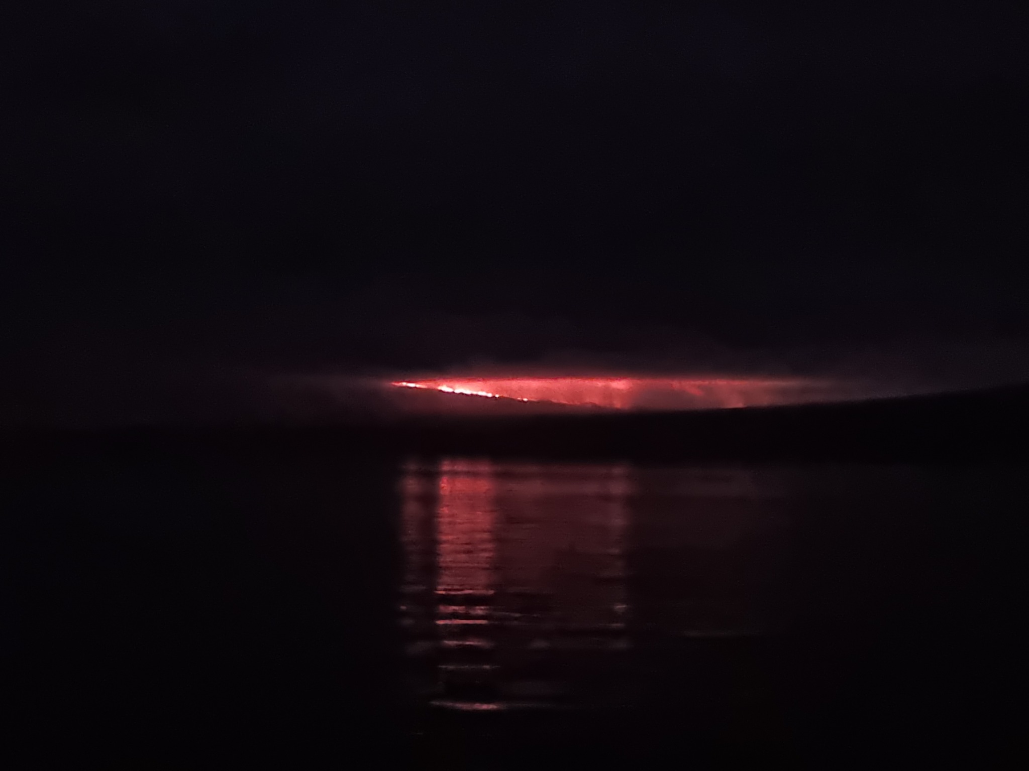
Low-level eruptive activity continues at Pavlof Volcano. Web camera views were obscured by clouds over the past day, but strongly elevated surface temperatures, suggestive of lava effusion, were observed in satellite images. Seismicity remains elevated with ongoing periods of tremor – also consistent with continued effusive activity. No explosive activity was recorded in the past day.

Small explosions accompanied by low-level ash emissions could happen at any time, and are typically a hazard in the immediate vicinity of the summit. The level of unrest at Pavlof can change quickly and the progression to more significant eruptive activity can occur with little or no warning.
Pavlof is monitored by local seismic and infrasound sensors, satellite data, web cameras, and remote infrasound and lightning networks.
Source : AVO.
Photo : Loewen, Matt / Alaska Volcano Observatory / U.S. Geological Survey.
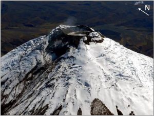
Hawaii , Kilauea :
19°25’16 » N 155°17’13 » W,
Summit Elevation 4091 ft (1247 m)
Current Volcano Alert Level: WATCH
Current Aviation Color Code: ORANGE
Activity Summary:
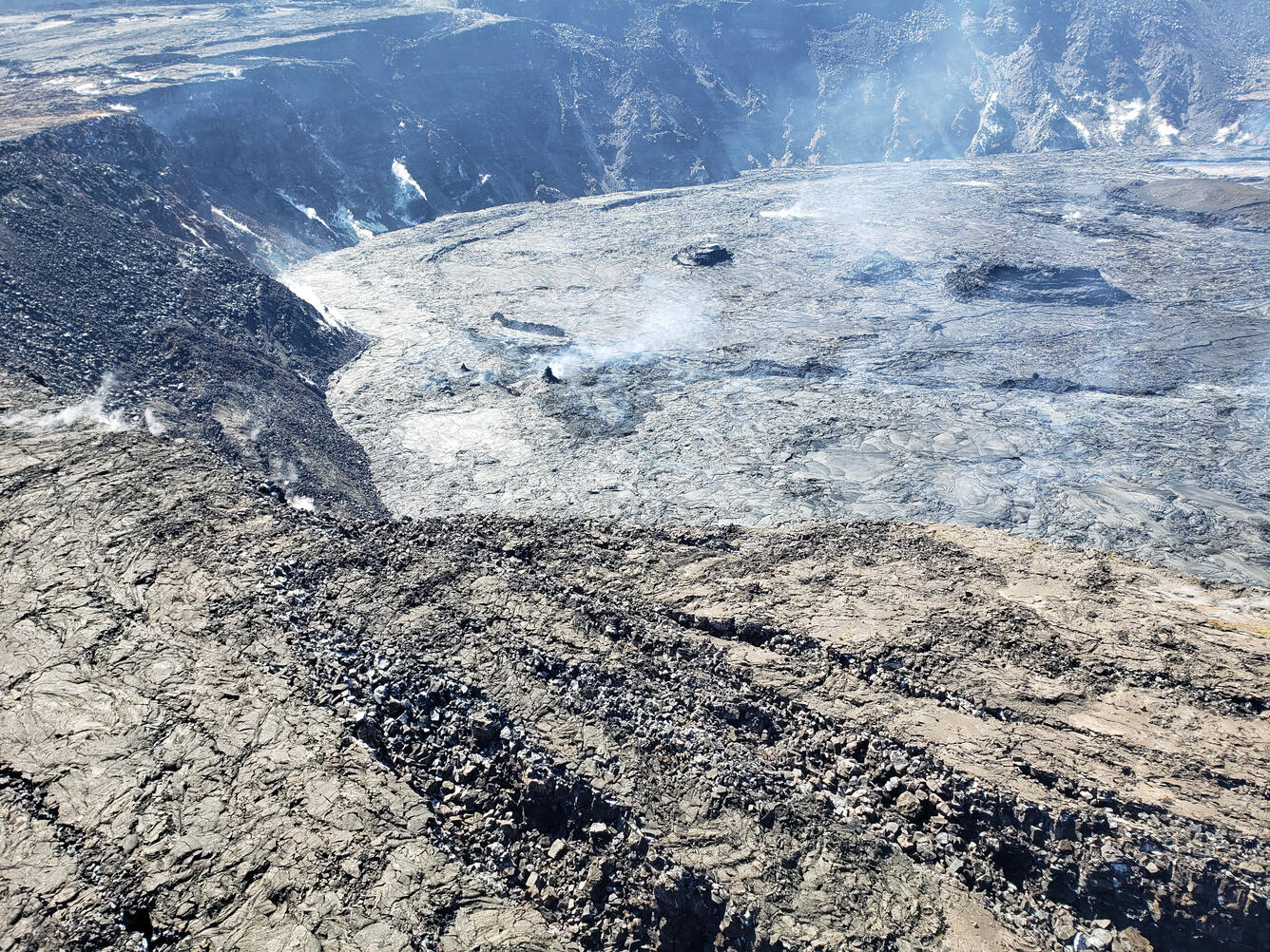
The summit eruption of Kīlauea Volcano, within Halemaʻumaʻu crater, has continued with slight fluctuations in lava output over the past 24 hours. Lava activity remains confined to the crater, and there are no indications of the eruption migrating elsewhere on Kīlauea.
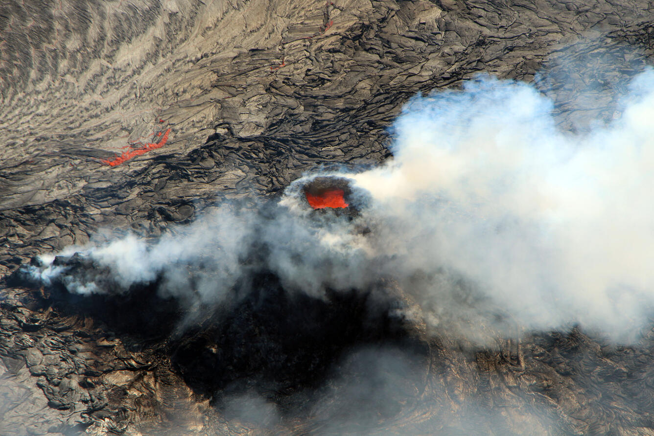
Photo of the west vent within Halema‘uma‘u crater, which has been built up with spattering lava thrown out since the current Kīlauea summit eruption began in September 2021. In this photo, the west vent interior glows and is emitting a heavy sulfur dioxide-rich plume. Very little spatter was being thrown out of the west vent when this photo was taken at around 9:30 a.m. on Tuesday, February 1, 2022, from the west rim of Halema‘uma‘u.
Halemaʻumaʻu Lava Lake Observations:
Effusion of lava from the western vent within Halemaʻumaʻu crater has continued with slight fluctuations over the past 24 hours. Output to the active lava lake in the western portion of the crater temporarily declined in association with the deflationary phases of two deflation-inflation (DI) events in the summit region yesterday, one in the morning and one in the afternoon. Another period of reduced output began early this morning as the summit deflated again. Unlike full eruptive pauses in recent weeks, the surface of the lava lake has not fully stagnated and crusted over during these DI events, although circulation has been slightly diminished. Multiple ooze-outs of lava have been active along the northern and eastern margins of the crater over the past 24 hours, dominated by one particularly vigorous ooze-out at the far eastern end of the crater.
On January 27, HVO scientists surveyed parts of the downdropped block in Kīlauea’s summit caldera, north of Halema‘uma‘u crater, for an area to deploy a new continuous gravity instrument funded through the Additional Supplemental Appropriations for Disaster Relief Act of 2019 (H.R. 2157) to support recovery and rebuilding activities in the wake of Kīlauea’s 2018 events. As the scientists were on the ground, they noted gas-jetting sounds being emitted by a small and steep spatter cone that has developed on the inactive lava lake surface in the eastern portion of Halema‘uma‘u. The spatter cone is visible near the center of this photo, which was taken from the north rim of Halema‘uma‘u and looks to the southeast.
During the deflationary phases of yesterday’s DI events in the morning and afternoon, the surface of the active lava lake respectively dropped approximately 4 meters (13 feet) and 2 meters (7 feet) before rising back up during the inflationary phase of each event. This morning the active lake surface dropped 5 meters (16 feet) during another period of summit deflation. The active lake surface has been stabilizing at 832 meters (2730 feet) above sea level between these DI events, with a depth of approximately 91 meters (299 feet) relative to when lava emerged on September 29, 2021. Measurements on January 28 indicated that the total lava volume effused since the beginning of the eruption was approximately 45 million cubic meters (12.0 billion gallons) at that time.
Summit Observations:
Summit tiltmeters tracked two DI events yesterday, one in the morning and one in the afternoon. Deflationary tilt returned early this morning, and just within the past hour there have been indications of a switch to inflationary tilt, which would complete yet another DI event. These events have only seen minimal declines in eruption-related volcanic tremor, unlike full eruptive pauses in recent weeks. Earthquake activity in the summit region remains below background level. A sulfur dioxide (SO2) emission rate of approximately 4,500 tonnes per day (t/d) was measured on February 1, the day before the most recent eruptive pause.
Source : HVO.
Photo : USGS / D. Downs. USGS /I. Johanson.
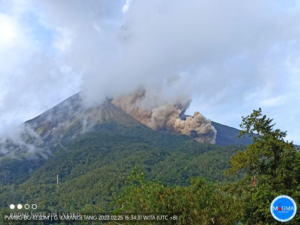
Ecuador , Sangay / Wolf :
DAILY REPORT OF THE STATE OF SANGAY VOLCANO. 05 February 2022 .
Surface activity level: High, Surface trend: No change.
Internal activity level: High, Internal trend: No change.
Seismicity: From February 04, 2022, 11:00 a.m. to February 05, 2022, 11:00 a.m.:
Due to issues in the reference station, updated seismic data is not available prior to the release of this report.
Rains / Lahars:
Light rain was recorded in the volcano area. **In the event of heavy rains, these could remobilize the material accumulated in the gullies, generating mudslides and debris that would descend through the drains of the volcano and flow into the adjacent rivers.**
Emission / ash column:
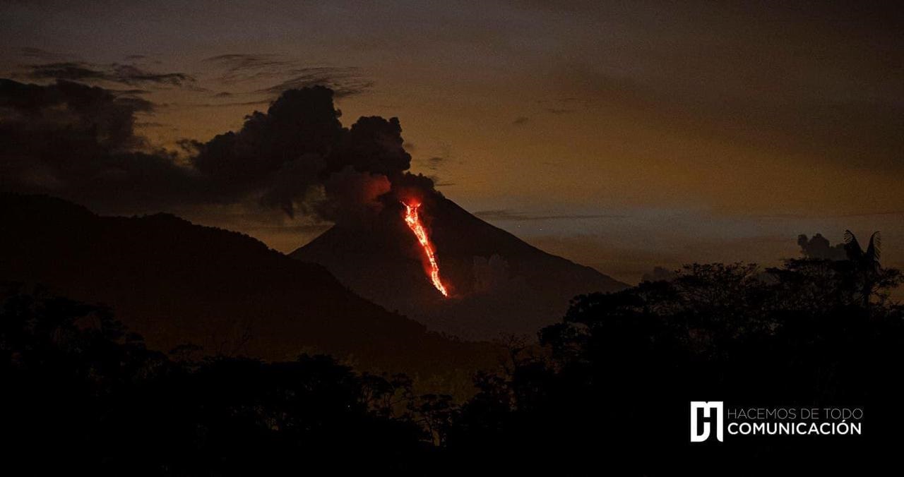
5 VAAC alerts were recorded in directions ranging from the South, South-West and South-East, which reached up to 1170 meters above the level of the crater. A constant emission of gas and ash was observed which reached about 1 km above the level of the crater in a southerly direction.
Other Monitoring Parameters:
In FIRMS, 34 thermal alerts are recorded, while MIROVA records 1 high (428 MW) and 1 moderate thermal alert in the last 24 hours.
Observation:
Regarding VAAC alerts, these have been recorded over the last 24 hours; while the emission indicated was seen this morning accompanied by projections of blocks on the southern flank. Last night, an alert for a possible ash fall was issued, which has not been confirmed in any of the sectors surrounding the volcano so far.
Alert level: yellow.
—————————————————————————————————-
DAILY REPORT OF THE STATE OF WOLF VOLCANO. 05 February 2022 .
Surface Activity Level: High, Surface Trend: Unchanged
Internal activity level: High, Internal trend: No change.
Seismicity: From February 04, 2022, 11:00 a.m. to February 05, 2022, 11:00 a.m.:
Type Volcano tectonic ( VT): 2
Emission / ash column:
The Washington VAAC reported no ash emissions. In satellite images (GOES-16), weak gas emissions were observed.
Other Monitoring Parameters:
The MIROVA satellite monitoring platform records 1 moderate and 2 very strong thermal alerts (1,547 and 3,503 MW), while FIRMS records 105 thermal alerts in the last 24 hours
Source : IGEPN.
Photos :IG-EPN / H communication , IGEPN.
La Martinique , Mount Pelée :
Weekly report on the activity of Mount Pelée for the period from January 14 to 21, 2022.
Between January 28, 2022 at 4 p.m. (UTC) and February 4, 2022 at 4 p.m. (UTC), the OVSM recorded at least 42 volcano-tectonic earthquakes of magnitude less than or equal to 1. These earthquakes were located inside the volcanic edifice between 0.5 and 1.0 km depth below the surface. This superficial volcano-tectonic seismicity is associated with the formation of micro-fractures in the volcanic edifice.
– since February 2, 2022, 2 long-period type earthquakes and 1 hybrid-type earthquake (with characteristics intermediate to those of volcano-tectonic and long-period type earthquakes) have been located. These signals are associated with the presence of fluids (gas, hydrothermal waters) in the volcanic edifice.
None of these earthquakes were felt by the population.
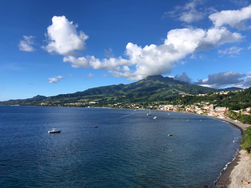
The zone of degassing at sea at shallow depth between St Pierre and le Prêcheur is still observed. The IGP took fluid samples in order to understand the origin of this degassing and to assess its possible relationship with the Mount Pelée hydrothermal system.
Vegetation is regrowing at the level of the main zone of degraded vegetation which is observed on the southwestern flank of Mount Pelee, between the upper Claire river and the Chaude river. However, new areas of deteriorated and dead vegetation have been detected by analysis of satellite images in the upper Claire River and near the Hot Springs.
The alert level remains YELLOW: vigilance.
Source : Direction de l’OVSM IPGP.
Photo : rci.fm