January 25 , 2022 .
Vanuatu Archipelago , Ambrym :
VOLCANO ALERT BULLETIN, 25th January 2022 at 11:42 am:
Ambrym volcano has now increased from the minor unrest state to the major unrest state. The Volcanic Alert Level increased from Level 1 to Level 2.
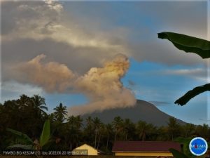
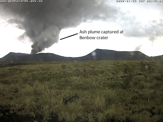
The volcano activity at Ambrym has now increased from the low unrest level to the major unrest level, consistent with the Volcanic Alert Level 2. New scientific analysis suggest that the Ambrym volcano activity has significantly increased today 25th January 2022 early morning around 4am. There were steam observed on Marum crater and significant steam, ash and gas observed on Benbow since 05:15am this morning. Volcanic hazards remain at the summit craters area and the South East part of Ambrym Island (e.g., major cracks from 2018).
Latest observations and daily analysis of the Ambrym seismic data from the volcano monitoring system confirm that the Ambrym volcano activity has increased and is continuing in the Major unrest Level. The lava lakes that used to appear in Benbow and Marum craters have disappeared since December 2018 eruption. The remaining activity inside active craters consists of ongoing steam emissions. People from Ambrym and neighboring islands will not see the volcanic glow at nights. With this current volcanic activity, it is a useful reminder that eruptions can occur at any level of unrest with little or no warning.
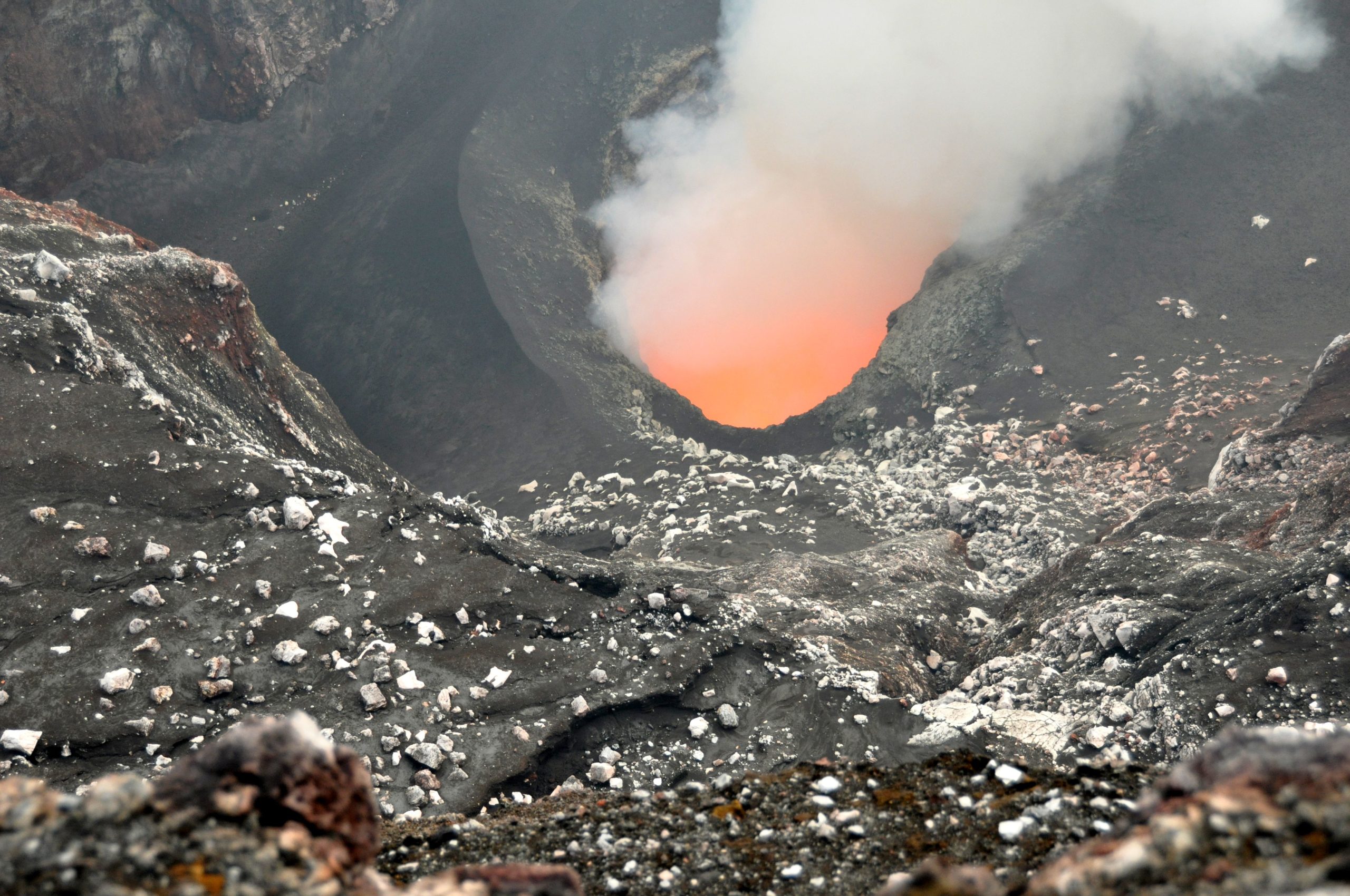
Ambrym volcano is a very active volcano in Vanuatu with large caldera of 12 km in diameter and 2 active craters, Marum and Benbow. The volcano has been active during historical time at both summit and flank vents, producing moderate explosive eruptions and lava flows that have reached the coast. The larger events include eruptions in 1820, 1894, 1913 or 1929. Over the last seventy years (before the 2018 eruption), there have been no eruptions that extended beyond the summit caldera. The eruption of 1988 and 2015 are focused in the caldera. The December 2018 eruption was focused in the summit caldera, and also affected the Eastern Fracture or Rift Zone with ground deformation, rifting, faulting and uplift, but no eruption occurred there.
Source : Geohazard.
Photos : Geohazard , G Vitton ( 2011).
Costa Rica , Turrialba :
Turrialba volcano activity report, January 24, 2022.
On January 24, 2022 at 7:06 a.m. local time, an eruption was recorded at the level of the Turrialba volcano, with a column that rose 100 meters above the height of the crater (3440 meters above sea level , or 11283.2 feet).
Duration of the activity: 2 minutes.
The winds blow from the southwest.
Ash falls reported: No ash fall is reported
Sulfur odor reported: No sulfur odor reported
Comments: The column reached a height of about 3329 m.
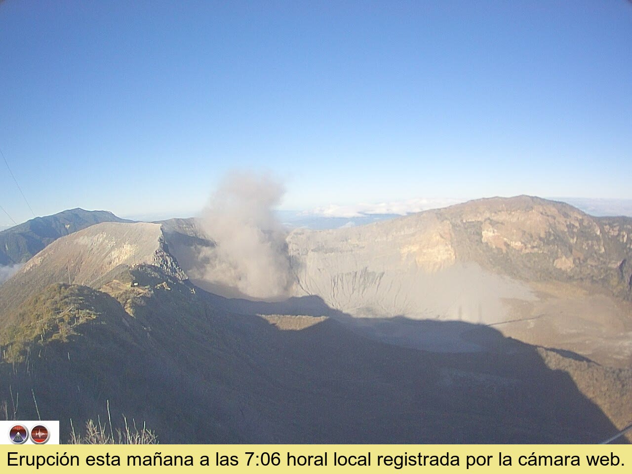
This morning an eruption occurred at 07:06 (GMT-6), the column rose about 100 meters above the top of the crater. Two points of incandescence are observed on the southwestern inner wall of the crater. The CO2/SO2 and H2S/SO2 gas ratios remain relatively stable: 21.6 and 0.3; respectively. As well as the SO2 concentration (5.7 ppm). The deformation of the volcanic edifice is not significant.
Source and photo : Ovsicori .
Peru , Sabancaya :
Analysis period: from January 17, 2022 to January 23, 2022, Arequipa, January 24, 2022.
Alert level: ORANGE
The Geophysical Institute of Peru (IGP) reports that the eruptive activity of the Sabancaya volcano remains at moderate levels, that is to say with the recording of an average of 40 daily explosions, with columns of ash and gases up to 3.0 km altitude above the summit of the volcano and their subsequent dispersion. Therefore, for the following days, no significant change is expected in eruptive activity.
The IGP recorded and analyzed the occurrence of 281 earthquakes of volcanic origin, associated with the circulation of magmatic fluids inside the Sabancaya volcano. An average of 40 explosions was recorded daily. During this period, Volcano-Tectonic (VT) type earthquakes associated with rock fracturing were located mainly in the northwest and southwest of Sabancaya and presented magnitudes of M 3.0.
Monitoring the deformation of the volcanic structure using GNSS techniques (processed with fast orbits) does not show any significant anomalies. However, in general, an inflation process has been observed in the northern sector (surroundings of the Hualca Hualca volcano). Visual surveillance identified columns of gas and ash up to 3.0 km above the summit of the volcano, which were dispersed towards the western, northwest and southwest sectors of Sabancaya. Satellite recordings have identified the presence of 4 thermal anomalies (maximum value of 10 MW) associated with the presence of a lava body on the surface of the crater of the volcano.
RECOMMENDATIONS
• Keep the volcanic alert level orange.
• Do not approach within a radius of less than 12 km from the crater.
Source et photo : IGP.
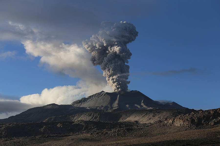
Indonesia , Semeru :
VOLCANO OBSERVATORY NOTICE FOR AVIATION – VONA
Issued : January 25 , 2022
Volcano : Semeru (263300)
Current Aviation Colour Code : ORANGE
Previous Aviation Colour Code : orange
Source : Semeru Volcano Observatory
Notice Number : 2022SMR13
Volcano Location : S 08 deg 06 min 29 sec E 112 deg 55 min 12 sec
Area : East java, Indonesia
Summit Elevation : 11763 FT (3676 M)

Volcanic Activity Summary :
Eruption with volcanic ash cloud at 00h41 UTC (07h41 local). Eruption and ash emission is continuing.
Volcanic Cloud Height :
Best estimate of ash-cloud top is around 12403 FT (3876 M) above sea level, may be higher than what can be observed clearly. Source of height data: ground observer.
Other Volcanic Cloud Information :
Ash-cloud moving to southeast.
Sources : Magma Indonésie , PVMBG.
Photo : Oystein Lund Andersen .
Hawaii , Kilauea :
19°25’16 » N 155°17’13 » W,
Summit Elevation 4091 ft (1247 m)
Current Volcano Alert Level: WATCH
Current Aviation Color Code: ORANGE
Activity Summary:
The summit eruption of Kīlauea Volcano, within Halemaʻumaʻu crater, is greatly diminished. Activity has been confined to a small pond north of the west vent cone. Since yesterday afternoon, lava input into the small pond has been intermittent, with several hours between short-lived periods of new lava input. All recent lava activity has been confined to the crater, and there are no indications of activity migrating elsewhere on Kīlauea.
Summit Observations:
Summit tiltmeters recorded inflation starting around midnight of January 22 to 23, 2022, which continued until this morning around 3 a.m. HST. Since then, summit tiltmeters have recorded deflation. Volcanic tremor associated with the eruption—as recorded by nearby seismometers—is steady and low, although still above pre-eruption background values. The most recent sulfur dioxide (SO2) emission rate of approximately 2100 tonnes per day was measured January 19, 2022, when lava activity was considerably more rigorous, while an SO2 emission rate of approximately 300 tonnes per day (t/d) was measured on January 11 during an eruption pause.
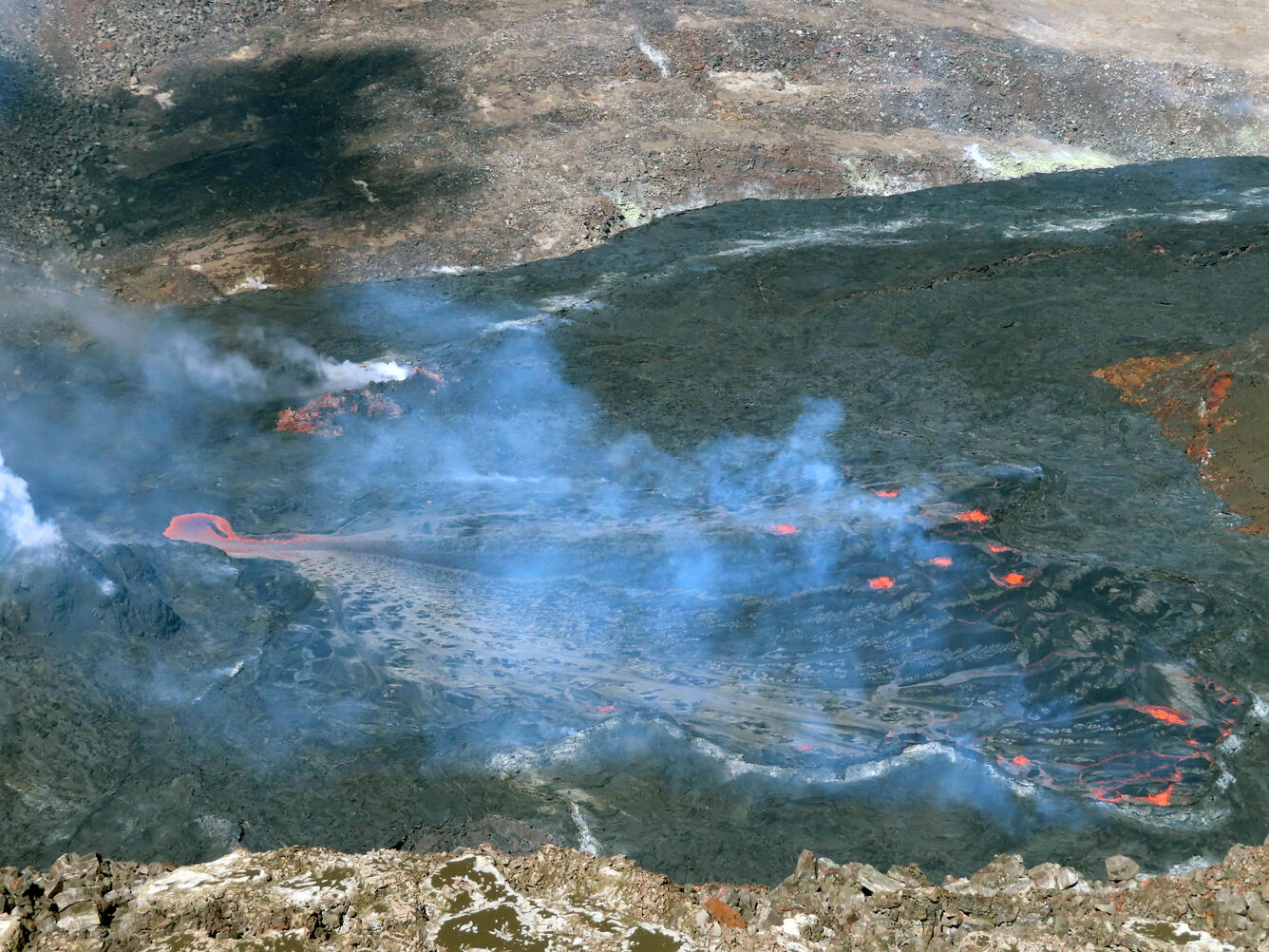
View of the western side of the lava lake within Halema‘uma‘u crater, at the summit of Kīlauea, on January 21, 2022. The image shows the west vent cone (lower left) and orange lava cascading from a pond just north of the west vent into the larger active lava lake to the east (right).
Halemaʻumaʻu Lava Lake Observations:
Over the past 24 hours, lava lake activity has has been confined to a small pond north of the west vent cone. Yesterday morning and early afternoon this small pond was active with constant new lava input and hot lava at the surface. Since about 3 p.m. HST yesterday, lava input into the small pond has become intermittent, exhibiting stop-and-go activity with several hours between short-lived periods of new lava input. Since yesterday morning, there have been several oozeouts along the northwest and south margins of the crater. The lava lake is about 73 meters (240 feet) feet deep relative to when lava emerged on September 29, 2021. Measurements on January 14, 2022 indicated that the total lava volume effused since the beginning of the eruption was approximately 45 million cubic meters (12.0 billion gallons) at that time.
Source : HVO.
Photo : USGS / J.M. Chang.