January 05 , 2022 .
Italy / Sicily , Etna :
WEEKLY NEWSLETTER from December 27, 2021 to January 02, 2022 (issue date January 04, 2022)
SUMMARY OF ACTIVITY STATUS
In view of the monitoring data, it is highlighted:
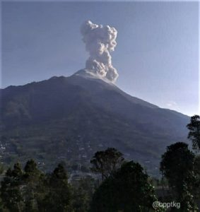
1) VOLCANOLOGICAL OBSERVATIONS: Degassing activity at variable rate of all the summit craters. Sporadic and weak emissions of very dilute ash from the crater of Bocca Nuova.
2) SEISMOLOGY: Seismic activity of weak fracturing; average amplitude of the volcanic tremor in the low level.
3) INFRASOUND: Weak infrasound activity.
4) SOIL DEFORMATION: GNSS
Soil Deformation Monitoring Networks Have Not Recorded Significant Changes Over the Last Week
5) GEOCHEMISTRY: SO2 flux at an average level.
Soil CO2 fluxes recorded by the Etnagas network at medium-high levels.
Partial pressure of dissolved CO2 at values consistent with the seasonal trend.
There is no update on the helium isotope ratio in peripheral manifestations (latest data from December 16, 2021 on medium-high levels).
There are no updates for the C / S report.
6) SATELLITE OBSERVATIONS: The thermal activity in the summit area observed by satellite was at a low level.
VOLCANOLOGICAL OBSERVATIONS
During the week in question, the monitoring of the volcanic activity of Mount Etna was carried out through the analysis of images from the INGV surveillance camera network, Etneo Observatory (INGV-OE) and through the remarks made remotely by INGV staff.
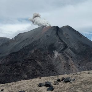
At the beginning of the week, observations were often made difficult by adverse weather conditions, while as of December 30, 2021, visibility was excellent. The period was characterized by variable rate degassing activity of all summit craters, with low fumerolian activity at Voragine crater and some high temperature points in the north inner wall of the southeast crater, and with degassing. from open mouths at the bottom of the Bocca Nuova and Northeast craters. Bocca Nuova degassing was pulsatile in nature, as already observed in recent months, and accompanied by rare and very low emissions of brown ash.
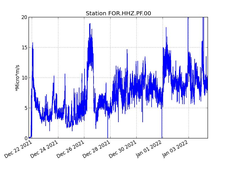
The average amplitude of the volcanic tremor remained mainly in the low value range. The locations of the centroids of the volcanic tremor sources involved a volume roughly in correspondence with the Northeast Crater, in a range mainly between 500 and 1500 m above average sea level.
Source : INGV.
Photo : Gio Giusa
La Réunion Island , Piton de la Fournaise :
Press release of January 04, 2022 – 3:00 p.m.
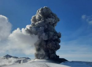
The eruption that began on December 22, 2021 at around 3:30 a.m. local time continues. Over the last 24 hours the amplitude of the eruptive tremor (indicator of an emission of lava on the surface) still shows fluctuations while remaining generally stable. The fluctuations observed can be linked either to:
– the cone and the field of lava tunnels downstream of the cone, which undergo phases of construction and dismantling, thus influencing the speed of lava flows at the level of the vent;
– or to punctual releases of pockets of gas trapped in the supply ducts which can be released suddenly leading to an increase in the tremor.
The average amplitude of the tremor is (over the last few days) about 55% of its initial amplitude.
A team from the Volcanological Observatory was able to visit the eruptive site today. Observations still show activity of lava fountains within the cone which has
built since the start of the eruption. The videos from the webcams of the OVPF-IPGP-IRT last night as well as the observations made that day near the vent, show a
activity with lava fountains that occasionally exceed the height of the cone. Overall, activity inside the eruptive cone appears to have decreased compared to yesterday. Numerous resurgences of lava flows are still visible at the roof of the lava tunnel that has developed downstream from the cone. These resurgences are sporadic and can last for
a few minutes to a few hours. In the first hundred meters downstream of the eruptive cone, the thickness of the flow was estimated at about fifteen meters.

Over the last 24 hours:
– Three volcano-tectonic earthquakes of low magnitudes (<1.0) were recorded under the summit.
– Surface deformations no longer show significant signals.
– The CO2 concentrations in the soil in the Gîte du volcan sector have become stable again for two days. This parameter will be monitored over the next few days because it may be linked to the arrival of a new magma, coming from deeper zones, at the level of the superficial reservoir.
– Lava flows could be estimated by satellite method with the HOTVOLC platform (OPGC – Clermont Auvergne University). They were between 2 and 9 m3 / sec. These variations are explained by the method, which relies on the infrared radiation of the flow, the perception of which by satellites can be largely influenced by the weather conditions above the flows as well as the surface conditions of the flows.

No precise assessment of the position of the casting front could be made. But given the relief with gently sloping slopes in the area, the lava field continues to extend mainly laterally and by thickening at the level of the network of lava tunnels set up on the plateau downstream of the eruptive cone. Observed from the vicinity of the vent, the flow front does not appear to have progressed significantly.
Alert level: Alert 2-1 (eruption in the Enclos )
Source et photos : OVPF.
Italy , Vulcano :
WEEKLY NEWSLETTER from December 27, 2021 to January 02, 2022 (issue date January 04, 2022)
SUMMARY OF THE STATUS OF THE ACTIVITY.
In view of the monitoring data, it is highlighted:
1) Temperature of the fumaroles of the crater: The temperature values are stable both on the edge of the crater and on the interior face.
2) Flux of CO2 in the crater area: The values of CO2 flux on the ground in the summit area (VCS) show a downward trend, while remaining high.
3) SO2 flux in the crater area: SO2 flux at a high level
4) Geochemistry of fumarolic gases: no update is available
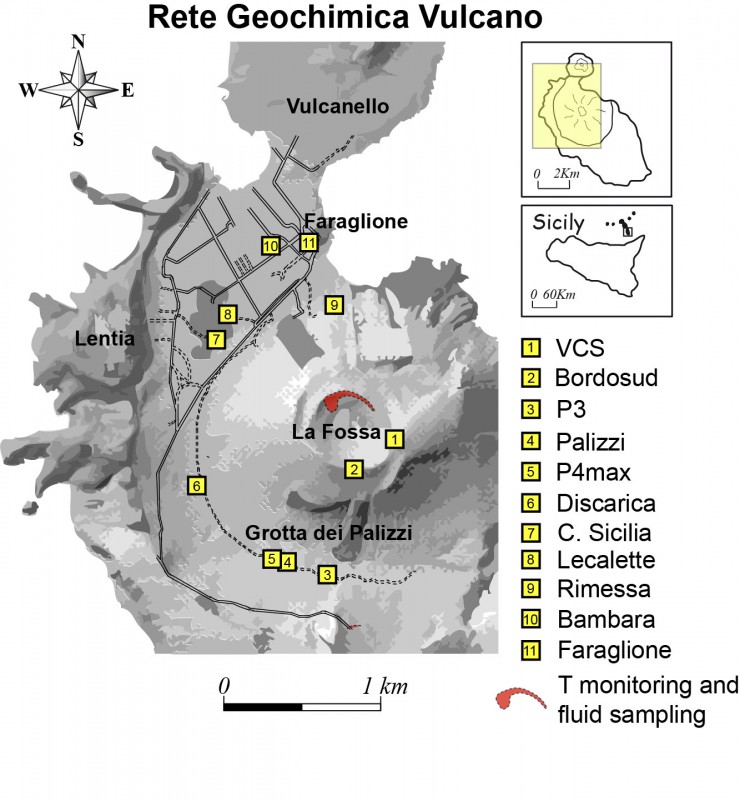
5) CO2 flux at the base of the La Fossa cone and in the Vulcano Porto area: The flux values at the base of the cone are stable, however settling on high values, with the exception of the Faraglione site , where the typical background values that characterize this site are recorded.
6) Geochemistry of thermal aquifers: The physico-chemical parameters of the Sicilia and Bambara Camping sites are stable.
7) Local seismicity: Low values of the rate of occurrence of the event.
8) Regional seismicity: Low fracturing seismicity associated with earthquakes with Ml> = 1.0.
9) Deformations – GNSS: The GNSS network does not show any variations during the period studied
10) Deformations – Inclinometry: The inclinometric network does not show any significant changes during the week examined.
11) Other observations: GB-RAR: The results of the GB-RAR monitoring referring to the period from December 14, 2021 to January 3, 2022, show a general stability of the zone, with deformations along the LOS of less than 1 mm .
Gravimetry: Continuous gravity stations did not record any significant changes during the period considered. The number of transients recorded has decreased considerably compared to previous weeks.

CRATER FUMAROLLES TEMPERATURE:
The downward trend, which began in November, in the temperature in the fumaroles on the edge of the crater continues (signals T_2 and T_3), while the thermal measurements on the internal face of the crater remain stable (signal T_0). During the past week, the maximum temperatures on the edge have remained stable around 300 ° C, while the temperatures inside do not exceed 110 ° C.
CO2 FLOWS IN THE CRATER ZONE
The flux of CO2 on the ground in the summit area (VCS) shows high values around 9000 g / m2 / day, remaining an order of magnitude above the averages recorded over the last 10 years. A gradual decrease in degassing is observed on a monthly scale
Source : INGV.
Photos : INGV.
Colombia , Nevado del Huilà :
Weekly activity bulletin of the Nevado del Huila volcano
The level of activity of the volcano continues at the level of yellow activity or (III): changes in the behavior of volcanic activity.
Based on the analysis and evaluation of the information obtained through the monitoring network of the Nevado del Huila volcano during the week between December 28, 2021 and January 3, 2022, the SERVICIO GEOLÓGICO COLOMBIANO – Volcanological and Seismological Observatory of Popayán reports that:
• During the period evaluated, 231 seismic events were recorded, of which 109 were related to rock fracturing processes (type VT) and 121 to fluid dynamics.
in volcanic conduits. Of these, 112 were classified as long period type events (LP type), 9 as tremor pulses (TR type) and 1 as hybrid (HB type).
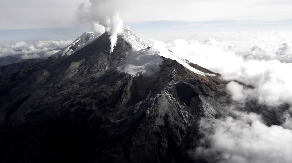
• The images obtained during the week by the Caloto, Tafxnú, Maravillas and La Palma web cameras showed low levels of degassing of the volcanic system, with a white column, oriented preferentially to the West.
• Sensors monitoring soil deformation, magnetic fields and infrasound waves did not record variations associated with changes in volcanic activity.
Therefore, it is concluded that during the evaluated period, the volcano continued to show stable behavior. The Colombian Geological Survey remains attentive to the evolution of the phenomenon
volcanic and will inform in a timely manner of any changes that may occur.
Source : SGC.
Photo : Parque Nacional.
Hawaii , Kilauea :
19°25’16 » N 155°17’13 » W,
Summit Elevation 4091 ft (1247 m)
Current Volcano Alert Level: WATCH
Current Aviation Color Code: ORANGE
Activity Summary:
The summit eruption of Kīlauea Volcano, within Halemaʻumaʻu crater, remains paused. Similar pauses in recent weeks have ranged in duration from 1 to 3 days. Inflationary trends began around 2 AM HST this morning and recovery of tilt suggests the eruption will restart within the next 24 hours. All recent lava activity has been confined to the crater, and there are no indications of activity migrating elsewhere on Kīlauea.
A magnitude-4.3 earthquake located east-northeast of Pāhala occurred yesterday on Monday, January 3, 2022, at 2:13 PM, HST. It was located 8 kilometers (5 miles) east-northeast of Pāhala, at a depth of 34 kilometers (21 miles), and produced a light shaking up to intensity IV on the Modified Mercalli Intensity Scale with no observable impact on the eruption of Kīlauea Volcano
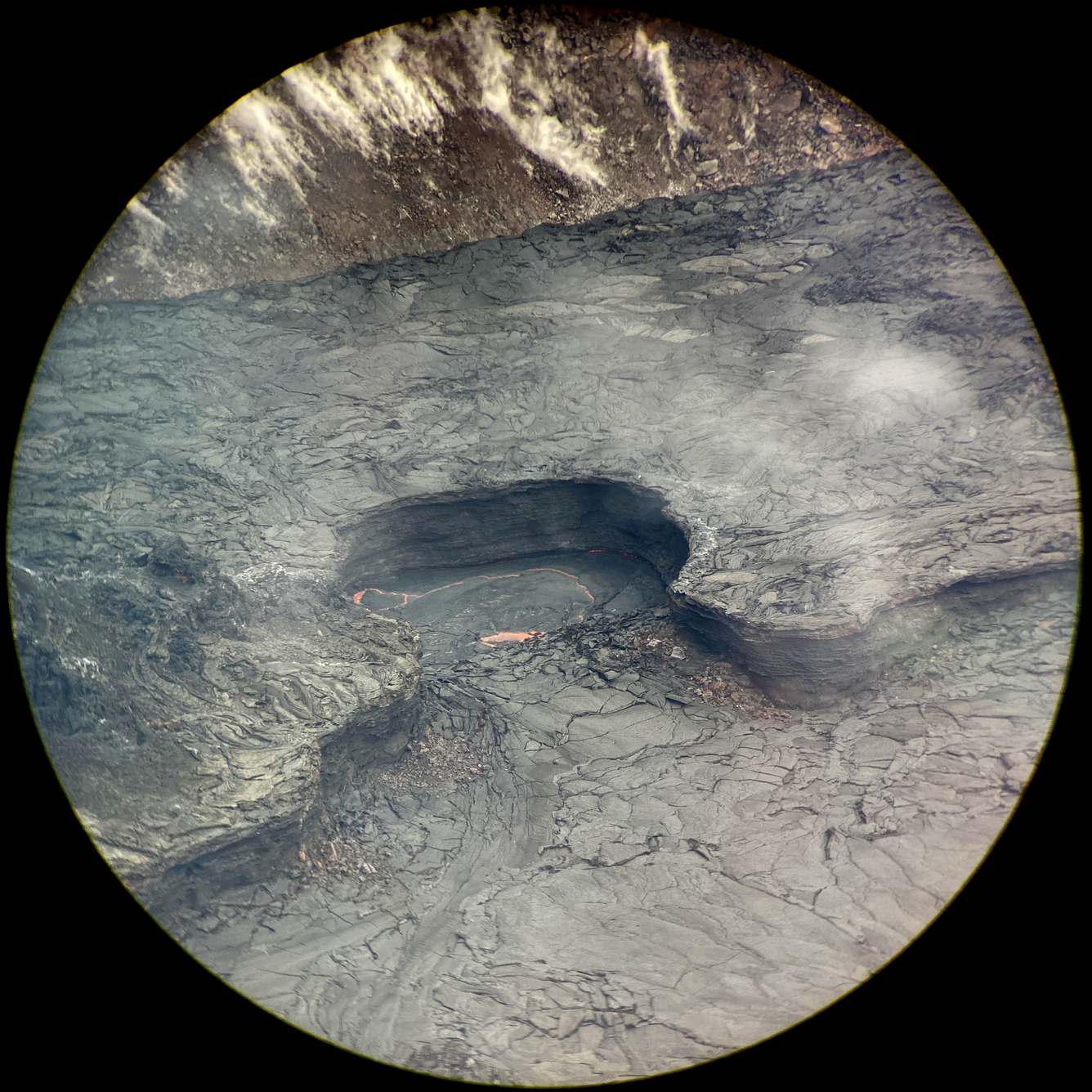
During recent multi-day pauses in the ongoing Kīlauea summit eruption, a small portion of the Halemaʻumaʻu lava lake has consistently remained active: a small, ovular lava pond just north of the briefly dormant western fissure. This photo of the lava pond was captured on Thursday, December 30, through the lens of a laser rangefinder device, and the western fissure is just out of frame to the left. Measurements indicated that the lava pond measured approximately 30 meters (98 feet) from end to end at that time. On previous occasions when more vigorous eruptive activity resumed, new breakouts of lava from the fissure and upwelling lava from the pond have reactivated the nearby crusted-over lava lake (lower right). A vertical levee, standing approximately 4 meters (13 feet) tall, bounds the lake and far edge of the pond; distinctive layering in the levee wall marks earlier lava levels when the lake was more full.
Summit Observations:
Summit tiltmeters began tracking inflationary trends around 2 AM this morning. Volcanic tremor associated with the eruption—as recorded by nearby seismometers—has not restarted yet. Earthquake activity in the summit region remains below background level. A sulfur dioxide (SO2) emission rate of approximately 5,000 tonnes per day was measured on December 28, 2021 in the summit region while the lava lake was very active.
Halemaʻumaʻu Lava Lake Observations:
Lava is not erupting from the western vent in Halemaʻumaʻu. Crust covers the lake and occasional small foundering events occurred north of the vent. The current inflationary trend indicates the eruption could restart within 24 hours.
Source : HVO
Photo : USGS/ M. Zoeller.