December 27 , 2021.
Iceland , Reykjanes Peninsula :
Update on the earthquake swarm in Geldingadalir , Update on 26.12. at 15:20
The earthquake swarm that started on 21st of December near Fagradalsfjall has continued over the Christmas holidays. Around 3000 earthquakes have been detected every day since the swarm started. Most of the activity is near Fagradalsfjall volcano but earthquakes have also been detected near the town of Grindavík and lake Kleifarvatn.
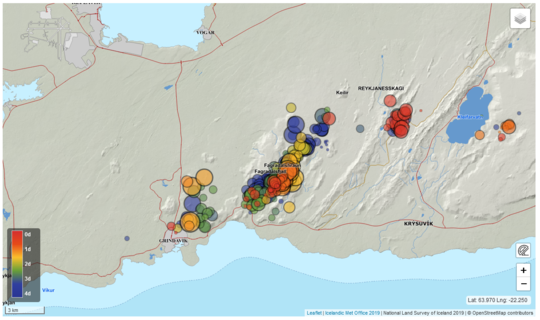
The earthquakes near Grindavík and Kleifarvatn are interpreted as triggered earthquakes due to increased pressure caused by a dike intrusion near Fagradalsfjall. On Christmas eve three earthquakes above M4 were detected near Grindavík, the largest one M4.8. There are no signs of magmatic intrusions in other places than by Fagradalsfjall. The earthquake activity by Fagradalsfjall is episodic with periods of very intense earthquake activity.
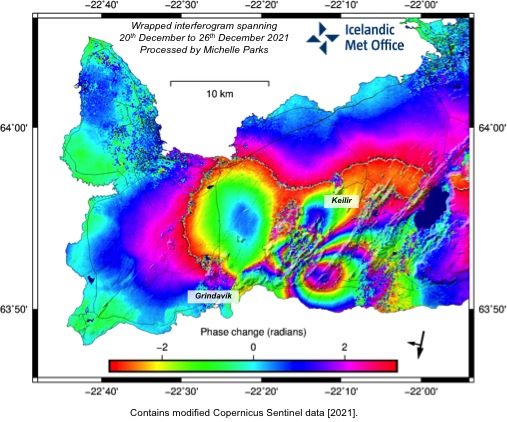
Latest InSAR images show clear signs of deformation over the period from 20 to 26 December. The deformation seen now is very similar to deformation observed in the end of February this year when a dike intrusion was starting near Fagradalsfjall. This InSAR data supports data from GPS measurements showing deformation in the same area.
At 15:25 an M3.9 earthquake occurred and a minute late another M3.6 earthquake was detected. Both of them were located 3 km W of Lake Kleifarvatn.This morning at around 05:10, four earthquakes were detected of magnitude 3 or larger in similar location. These earthquakes are interpreted as triggered earthquakes due to increased pressure caused by a dike intrusion near Fagradalsfjal.
Source : Vedur is.
Photos : IMO.
La Réunion Island , Piton de la Fournaise :
Press release of December 27, 2021 – 10:15 a.m.
The eruption that began on December 22, 2021 at around 3:30 a.m. local time continues. Over the last 24 hours the amplitude of the eruptive tremor (indicator of an emission of lava on the surface) still shows fluctuations. These fluctuations can be linked either to:
– the cone under construction which undergoes construction and dismantling phases, thus influencing the speed of the lava flows at the level of the vent;
– or to punctual releases of pockets of gas trapped in the supply ducts which can be released suddenly leading to an increase in the tremor.
The amplitude of the tremor is this morning at about 30% of its initial amplitude.
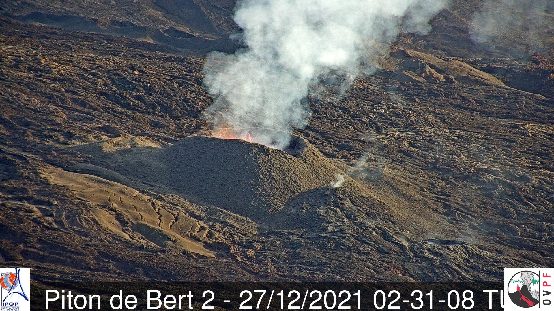
The lava tunnel activity set up at the foot of the cone since December 23, 2021, thanks to the closure of the cone, continues, with occasional resurgences of flows. Following
resurgences observed yesterday, a second mouth was visible at the foot of the cone this morning. The main flow does not emerge in a single channel until about a hundred meters downstream.
Lava fountain activity within the cone is low, and lava fountains exceed the height of the cone (<15m) only intermittently.
Interferometric data from satellite acquisitions on December 25 and 26, and processed by the ISDeform observation service, confirm that the surface deformations associated with
the magma injection on December 22 is decimetric and extends from the summit area to the eruptive site. The area between the southern edge of the Dolomieu crater and the Château Fort crater has thus deformed by around twenty centimeters. No significant deformation beyond the eruptive site is observed. These data agree with the data from the permanent GPS stations of the OVPF-IPGP.
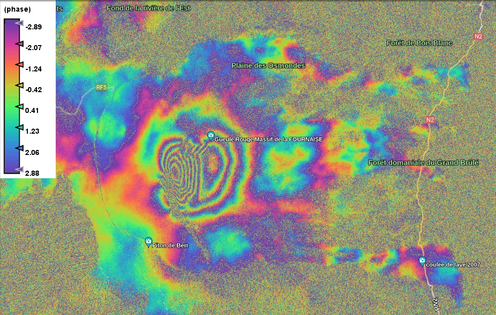
Interferogram representing the deformations at Piton de la Fournaise associated with the eruption of December 22, 2021. In addition to measurements on the ground, a satellite technique called dInSAR also makes it possible to monitor the building’s inflation / deflation cycles associated with movements. magma in depth. To do this, the satellite “illuminates” an area of the ground with an electromagnetic wave and collects the signal reflected from the ground. Comparison of two measurements of this type of the same surface taken at different times allows the deformation of the surface to be imaged. Each complete color cycle (from red to blue) of the interferogram corresponds to 27.8 mm of surface displacement towards (positive) or away (negative) of the satellite (© ISDeform).
Over the last 24 hours:
– A single volcano-tectonic earthquake under the summit was recorded.
– Surface deformations no longer show significant deformation.
– The lava flow estimates, established by satellite method with the HOTVOLC platform (OPGC – Clermont Auvergne University), are between 3 and 12 m3 / sec. These variations can be explained by the method, which is based on the infrared radiation of the flow, the perception of which by the satellites can be largely influenced by the weather conditions at above the flows.
– The front of the flow, in graton, currently on a relatively flat area, moves only very slowly. The flow front advanced less than 100 meters between December 24 and 26.
Alert level: Alert 2-1 (eruption in the Enclos ).
Source : OVPF/IPGP.
Vanuatu Archipelago , Yasur :
19°32’0”S 169°26’30”E
Summit 1184ft (361m)
Current Volcano Alert Level: Level 2
Yasur volcano activity is continuing in the level of major unrest state. The Volcanic Alert Level remains at Level 2.
New observations on the ground suggest that the Yasur volcanic activity continues to produce loud explosions with emission of steam and ash including volcanic bombs that fall inside the crater. With this current activity and ongoing presence of volcanic gases and/or volcanic ash around the summit crater, the danger zone is now at 600 meter around the volcanic cone.
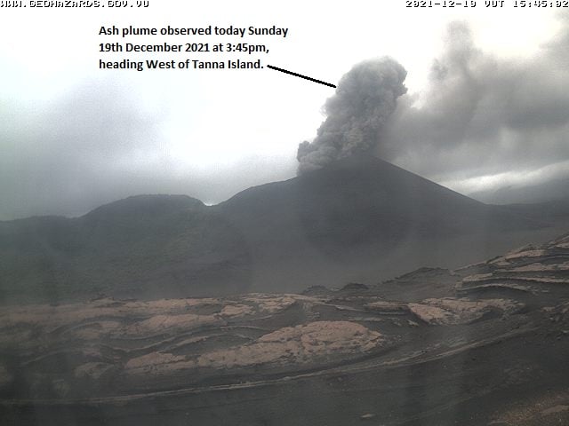
Analysis of the latest Yasur seismic data from the volcano monitoring system confirms that Yasur volcano activity is continuing in the major unrest level. The activity consists of ongoing explosions with gas plumes and/or volcanic ash. Some explosions remain intensified and volcanic projectiles or bombs may fall in and/or around the summit crater.
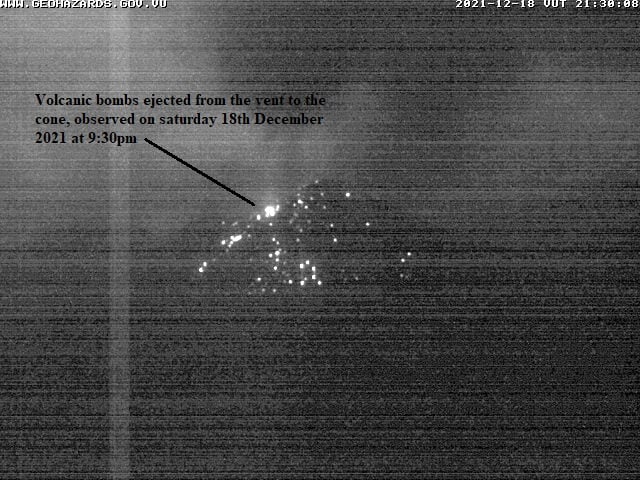
The Yasur Volcanic Alert Level (VAL) has remained in Level 2 since the 18th October 2016. The current observations are consistent with the activity of the Volcanic Alert Level 2. Level 2 indicates ‘Major level of unrest; Danger zone is reduced to 600 m around the volcanic cone. With this current volcanic activity, it is a useful reminder that eruptions can occur with little or no warning.
Source et photos : Geohazard.
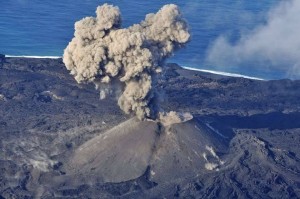
Ecuador , Sangay :
DAILY REPORT ON THE STATE OF SANGAY VOLCANO. December 26, 2021.
Surface activity level: High, Surface trend: Ascending.
Internal activity level: High, Internal trend: Ascending.
Seismicity: From December 25, 2021, 11:00 a.m. to December 26, 2021, 11:00 a.m .:
Long period type events (LP) 56
Explosions (EXP) 117
Emission Tremors (TREMI) 15
Rains / Lahars:
No rain was recorded. ** In the event of heavy rains, they could re-mobilize the material accumulated in the gullies, generating mudslides and debris that would descend through the drains of the volcano and flow into adjacent rivers. **
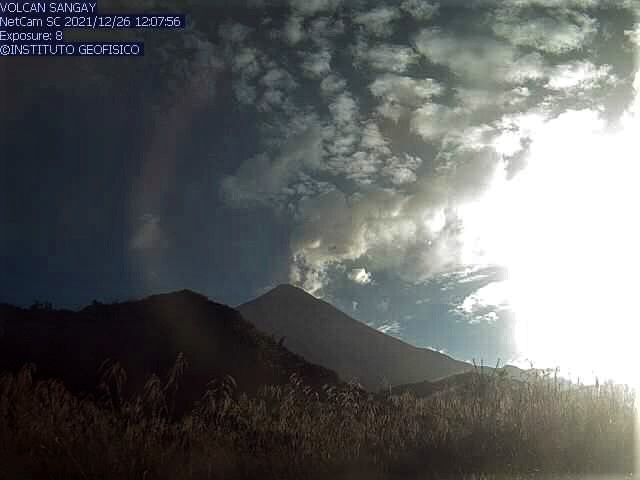
Emission / ash column:
Low ash load gas emissions have been observed with heights of up to 1000 meters above crater level in a south-easterly direction. 3 VAAC ash emission alerts were recorded with directions to the South and Southeast, with altitudes of up to 1170 meters above crater level. There are no reports of ash fall at the national level.
Other monitoring parameters:
The MIROVA satellite recorded 2 high thermal alerts, of 756 and 438 MW during the last 24 hours. The FIRMS satellite records 58 thermal alerts in the last 24 hours.
Observation:
In the afternoon of yesterday, members of the network of volcanic observers (ROVE) near the city of Macas (province of Morona Santiago), reported noises coming from the Sangay volcano. These noises are perceptible by the presence of clouds and south-easterly winds. On the other hand, the seismic records show a slight increase in the intensity of the explosions in the last hours, however, these events are associated with the high levels, characteristic of the activity of the volcano. For the moment, the volcano sector is cloudy.
Alert level: yellow.
Source et photo : IG-EPN.
Spain , Tenerife :
Today we must also look at Tenerife, where there has been an ongoing seismic swarm for almost 5 years in the region of Adeje – Vilaflor with a seismic localization at about 5 to 8 km deep and that during of the last 5 days. Also, there are constraints around a seismic axis in the North-North-East-South-South-West direction which cause it to move seismically and, hopefully, will not last long, because if a path is cut in rock, magma will begin to move along this path.
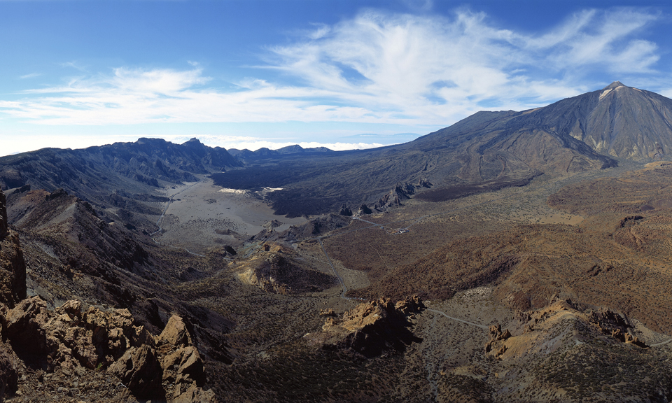
Today’s earthquake at Icod de Vinos of M 1.1 at 9 km is very interesting since we also had another one of M 1.1 at 10 km on September 27 in an area that made a lot of talk in April – May 2004 (an eruption was expected in October 2004) and hopefully it stays calm, but every time it moves it’s dangerous. This area is also aligned with the Caldera area, the Adeje swarm and even a 2.7 earthquake in the south, denoting very clear regional efforts.

But the problem is neither the Icod de los Vinos earthquakes nor the Adeje earthquakes, the biggest problem is that this activity affects to some extent what is below the central Teide building / Pico Viejo in the center of the island of Tenerife. More precisely, it is necessary to refer to the phonolitic magmatic chamber which is located between 12 and 15 km under the caldera of Las Cañadas del Teide. The 2004 intrusion ended there, the 2016 intrusion in Adeje and subsequent ones also affect the magma chamber in one way or another, so the system is more complex than it looks.
Sources : Volcanes y Ciencia Hoy ( Henrique) , Involcan.
Photos : volcanoteide.com , Involcan.