December 16 , 2021.
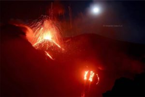
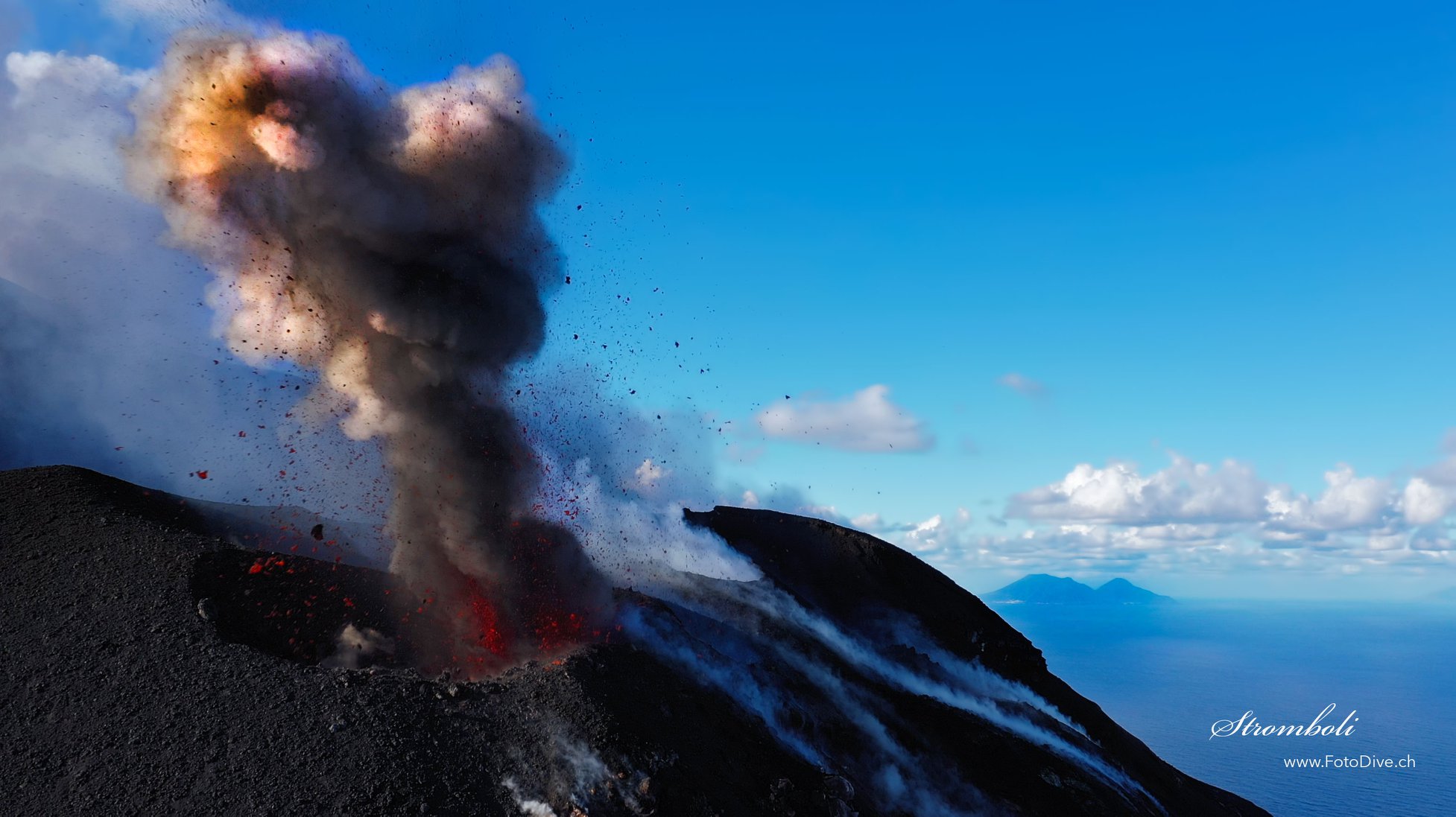
Italy , Stromboli :
WEEKLY NEWSLETTER from December 06, 2021 to 12/12/2021, (issue date 12/14/2021)
In view of the monitoring data, it is highlighted:
1) VOLCANOLOGICAL OBSERVATIONS: During this period, a normal explosive activity of Strombolian type was observed with splashing activity in zone N. The total hourly frequency of the explosions fluctuated between medium and medium-high values (14-20 events / h). The intensity of the explosions varied from low to medium in the North crater area and from low to high in the Center-South crater area.
2) SEISMOLOGY: The seismological parameters monitored do not show significant variations.
3) SOIL DEFORMATION: No significant change to report.
4) GEOCHEMISTRY: The flow of SO2 at an average level
The values of the CO2 flows recorded on the Pizzo Sopra La Fossa are at high levels.
The updated C / S ratio values were at high levels (C / S = 14.21).
There is no update of the value of the isotopic ratio of Helium dissolved in the thermal aquifer of Stromboli.
5) SATELLITE OBSERVATIONS: After the effusive event of November 26, the thermal activity observed by satellite showed low level anomalies.
VOLCANOLOGICAL OBSERVATIONS
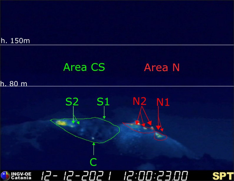
During the observation period, the eruptive activity of Stromboli was characterized by the analysis of the images recorded by the surveillance cameras of the INGV-OE (altitude 190m, Punta Corvi, altitude 400m and Pizzo). The explosive activity was mainly produced by 5 (five) eruptive chimneys located in the North crater area and 3 (three) eruptive chimneys located in the Center-South crater area. All the vents are placed inside the depression which occupies the terrace of the crater. Due to unfavorable weather conditions on December 6, 9 and 11, 2021, the visibility of the crater terrace was insufficient for a correct description of the eruptive activity.
Sector N1, with two emission points, located in the area of the North crater produced explosions of mainly medium-low intensity (sometimes the products of the explosions exceeded 80 m in height) emitting coarse materials (lapilli and bombs) . Sector N2, with three emission points, showed explosive activity of medium-low intensity (sometimes the products of the explosions exceeded 80 m in height) emitting coarse materials with weak and occasional throwing activity which became intense and continued on December 12. The average frequency of explosions varied from 8 to 16 events / h.
In the Center-South zone, sector S1 did not show significant explosive activity, while the two vents located in sector S2 produced explosions, sometimes at the same time, of mainly medium-low intensity (sometimes the products of the explosions exceeded 80 m in height) emitting coarse matter. Note that on December 12 the intensity of the explosions was high (many explosions exceeded 150 m in height). Sector C saw only modest explosions, emitting coarse materials only on December 12. The frequency of the explosions varied from 4 to 6 events / h.
Source : INGV
Photos : INGV , Willie FotoDive.
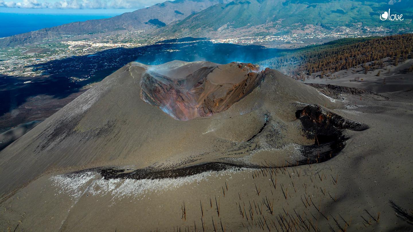
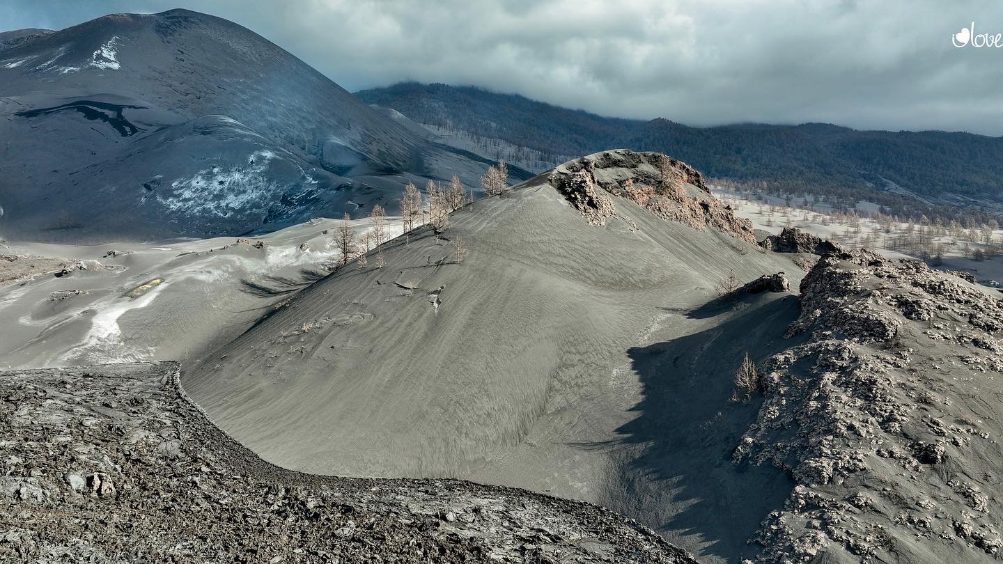
Spain / La Palma , Cumbre Vieja :
December 15, 2021, 09:00 UTC. Eruptive activity continues on La Palma.
Since the last declaration, a total of 41 earthquakes have been located on the island of La Palma, three of which were felt by the population.
The maximum recorded magnitude is 3.2 (mbLg), corresponding to yesterday’s earthquakes at 10:15 a.m. and 12:19 p.m. UTC, at depths of 13 and 14 km, respectively. The minimum magnitude of the localized earthquake was 1.0 mbLg.
Seismicity continues below the central area of Cumbre Vieja in the same areas of the past few days. Most earthquakes (34) are located at depths between 9 and 16 km. Three earthquakes were also located at depths between 36 and 39 km and four at depths between 1 and 3 km.
The amplitude of the tremor signal over the past 24 hours has remained at levels close to the pre-eruptive period.
The island’s network of permanent GNSS stations does not show a clear trend in the deformation of the stations closest to the eruptive centers.
In the rest of the stations, the slight deflation possibly linked to the deep seismicity has stabilized.
In view of the image calibrated at 08:30 UTC, no type of emission is visible.
The height of the cone is measured by obtaining a value of 1,123 m at sea level.
María José Blanco, director of the National Geographic Institute of the Canary Islands, said on Wednesday that the eruption of the Cumbre Vieja volcano in La Palma may not yet be over, although the lack of observable signs « both directly on surfaces and from monitoring systems that corroborate signs of exhaustion of the eruptive process ”. « Although a further increase in Strombolian activity and the emission of flows is not excluded, the recorded data and the observable data must be maintained at current levels for 10 days », stressed Blanco during the conference of press after the meeting of the Steering Committee of the Volcanic Emergency Plan of the Canary Islands (Pevolca). Spokesman Miguel Ángel Morcuende also insisted and called for waiting « zero activity » in 10 days to declare the eruption over.
Blanco then summarized the different parameters that are now taken into account on the low volcanic activity: “There is no evidence of lava flow from the outflow of the volcanic tubes; the lava delta that ran over the previous lavas has stopped; fumarolic activity is temporary and sporadic; the walls of the craters continuously occur small collapses. On meteorology, the IGN director stressed that now north-westerly winds predominate. « In the event that ash was emitted by the volcano, the dispersion of the plume would be towards the south-east and this would be an unfavorable scenario for aeronautical operations, » he said.
Sources : IGNes , El Pais .
Photos : I love the world.
Italy / Sicily , Etna :
15 December 2021, 18:59 (17:59 UTC). Press release on Etna’s activity.
The National Institute of Geophysics and Volcanology, Osservatorio Etneo, announces that the images of the CCTV system and the observations made by the staff of INGV present in the summit area show that the lava flow produced by the vent that s’ is open at an altitude of 2180 m in the Valle del Bove, is no longer powered and cools overall. The Southeast crater continues to produce weak intracrater Strombolian activity, as already described in Communiqué N. 529.

From a seismic point of view, the decrease in the mean amplitude of the volcanic tremor continued. It has now reached the low value range. The source of the volcanic tremor is located in correspondence with the summit craters at an altitude of about 2500 m above sea level. The rate of occurrence of infrasound events is low with sources mainly located in the area of the Bocca Nuova crater. Analysis of data from soil deformation monitoring networks (inclinometric and GPS) has not revealed any significant anomalies since the last update announcement.
Further updates will be communicated shortly.
Source : INGV.
Photo : Gio Giusa .
Philippines , Taal :
TAAL VOLCANO BULLETIN 16 December 2021 8:00 AM
In the past 24-hour period, the Taal Volcano Network recorded one hundred thirty-nine (139) volcanic earthquakes, including one hundred fourteen (114) volcanic tremor events having durations of two (2) to thirty-two (32) minutes, twenty-five (25) low frequency volcanic earthquakes, and low-level background tremor that has persisted since July 7, 2021. Activity at the Main Crater was dominated by upwelling of hot volcanic fluids in its lake which generated plumes 900 meters tall that drifted southwest. Sulfur dioxide (SO2) emission averaged 3,590 tonnes/day on 15 December 2021. Based on ground deformation parameters from electronic tilt, continuous GPS and InSAR monitoring, Taal Volcano Island and the Taal region has begun deflating in October 2021.
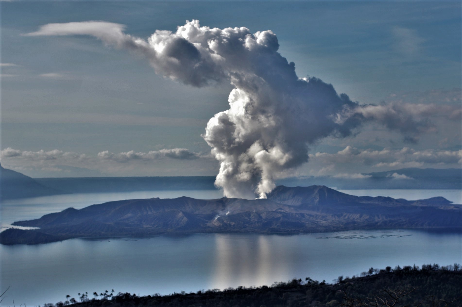
Alert Level 2 (Increased Unrest) prevails over Taal Volcano. DOST-PHIVOLCS reminds the public that at Alert Level 2, sudden steam- or gas-driven explosions, volcanic earthquakes, minor ashfall, and lethal accumulations or expulsions of volcanic gas can occur and threaten areas within and around TVI. DOST-PHIVOLCS strongly recommends that entry into Taal Volcano Island, Taal’s Permanent Danger Zone or PDZ must be strictly prohibited, especially the vicinities of the Main Crater and the Daang Kastila fissure, and extended stays on Taal Lake.
Source : Phivolcs.
Photo : Richard Langford ( archive 2020).
Japan , Suwanosejima :
JMA reported that crater incandescence at Suwanosejima’s Ontake Crater was visible nightly during 6-13 December. No explosions were detected by the seismic network, though eruption plumes rose 1-3.4 km and material was ejected 400-700 m away from the crater. Ashfall was reported in Toshima village (4 km SSW). The Alert Level remained at 3 and the public was warned to stay 2 km away from the crater.
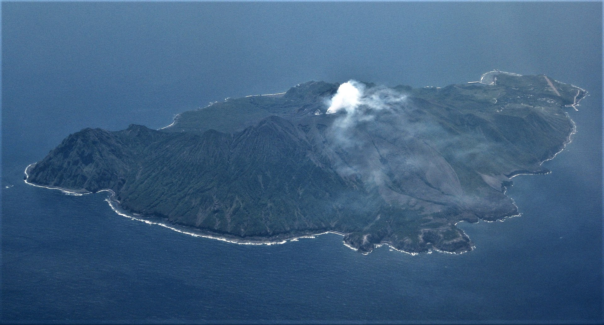
The 8-km-long, spindle-shaped island of Suwanosejima in the northern Ryukyu Islands consists of an andesitic stratovolcano with two historically active summit craters. The summit is truncated by a large breached crater extending to the sea on the east flank that was formed by edifice collapse. Suwanosejima, one of Japan’s most frequently active volcanoes, was in a state of intermittent strombolian activity from Otake, the NE summit crater, that began in 1949 and lasted until 1996, after which periods of inactivity lengthened. The largest historical eruption took place in 1813-14, when thick scoria deposits blanketed residential areas, and the SW crater produced two lava flows that reached the western coast. At the end of the eruption the summit of Otake collapsed forming a large debris avalanche and creating the horseshoe-shaped Sakuchi caldera, which extends to the eastern coast. The island remained uninhabited for about 70 years after the 1813-1814 eruption. Lava flows reached the eastern coast of the island in 1884. Only about 50 people live on the island.
Sources: GVP ,Japan Meteorological Agency (JMA)
Photo : Ray Go
Hawaii , Kilauea :
19°25’16 » N 155°17’13 » W,
Summit Elevation 4091 ft (1247 m)
Current Volcano Alert Level: WATCH
Current Aviation Color Code: ORANGE
Activity Summary:
Kīlauea volcano resumed erupting from a single vent in the western wall of Halemaʻumaʻu crater around 9 p.m. on Monday, December 13, 2021. The vent is supplying lava to a lava lake in the western portion of the crater. All recent lava activity remains confined within Halemaʻumaʻu crater in Hawai‘i Volcanoes National Park.
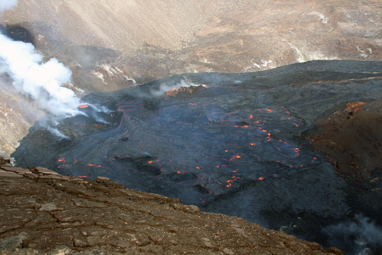
View of the active western half of the lava lake in Halema‘uma‘u at the Kīlauea summit. The main island that serves as a boundary between the active (west) and inactive (east) parts of the lake is the brown area in the middle right side of this photo. In this view looking northwest, the western fissure cone is visible in the middle left, with a prominent perched lava pond at its top. Lava enters the lava lake at the base of the western fissure cone. Small localized crustal foundering, some with low level spattering, is visible as red hot patches around the lake surface.
Summit Observations:
Deflationary tilt was present for most of yesterday, December 14, 2021, and continues this morning. Earthquake activity remains below background. The most recent measurement of sulfur dioxide (SO2) emission rate on December 14, 2021, was approximately 3,200 tonnes per day, consistent with the resumed eruption activity.
Halemaʻumaʻu Lava Lake Observations:
Lava is erupting from the same western vent, refilling the former lake area with fresh lava this morning. The lake has seen a total increase of about 65 meters (213 ft) since lava emerged on September 29. The total erupted volume since the beginning of the eruption was estimated to be about 30 million cubic meters (7.8 billion gallons) on November 16.
Source : HVO.
Photo : USGS / N. Deligne.