December 15 , 2021.
Italy / Sicily , Etna :
WEEKLY NEWSLETTER from December 06, 2021 to December 12, 2021 (issue date December 14, 2021)
SUMMARY STATUS OF THE ACTIVITY
In view of the monitoring data, it is highlighted:
1) VOLCANOLOGICAL OBSERVATIONS: Strombolian activity with low emissions of volcanic ash from the Southeast Crater, degassing activity at the level of the other summit craters.
2) SEISMOLOGY: Absence of seismic fracturing activity with Ml> = 2.0; the amplitude of the volcanic tremor at an average-high global level.
3) INFRASONS: Weak infrasound activity.
4) SOIL DEFORMATION: No significant change to report
5) GEOCHEMISTRY: The flow of SO2 appears at an average and increasing level.
The flow of CO2 emitted by soils recorded by the EtnaGAS network last week shows a downward trend, settling on low values.
The partial pressure of CO2 dissolved in water shows a decrease even though it is at average levels.
The isotope ratio of helium arises on medium-high values (the latest data from 11/30/2021) remaining almost constant compared to the previous values
There are no updates for the C / S report.
6) SATELLITE OBSERVATIONS: The thermal activity in the summit area was at a low level after the end of the Strombolian activity in the Southeast Crater on November 4 and 5.
VOLCANOLOGICAL OBSERVATIONS
During the week, the monitoring of the volcanic activity of Etna was carried out thanks to the analysis of the images of the surveillance cameras of the INGV, Osservatorio Etneo (INGV-OE). Due to the inclement weather conditions, for most of the week, the observation of volcanic activity by cameras was significantly limited.
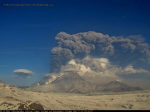
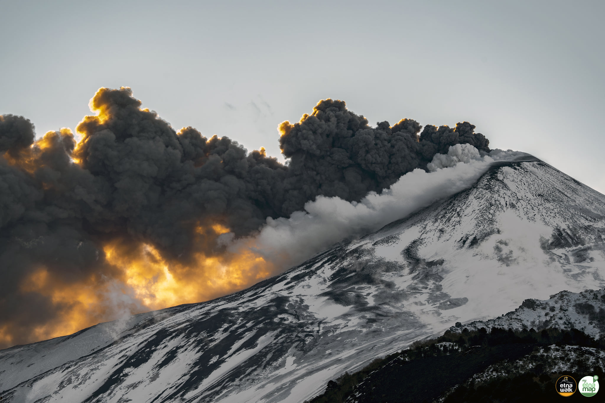
In general, the week was characterized by variable rate degassing activities of all summit craters, with the exception of the Southeast Crater (SEC), which produced ash emissions during the first part of the week. .
In particular, on December 6, the Southeast Crater (SEC) fueled an intracrater Strombolian activity with almost continuous ash emissions which were dispersed in the East-North-East direction and in any case near the area. Summit . This activity also continued on December 7. On December 8, the continuous emission of ash was no longer observed; however, a light discontinuous emission of very dilute ash remained, which was scattered near the summit area.
For the rest of the week, according to any observations from surveillance cameras, the Southeast Crater (SEC) was characterized by continuous degassing.
As for the other summit craters, these were characterized by degassing mainly in the crater of Bocca Nuova (BN), which fed an almost continuous degassing, sometimes pulsatile.
December 14, 2021. 12:44 (11:44 UTC). Press release on ETNA’s activity.
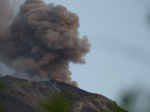
The National Institute of Geophysics and Volcanology, Osservatorio Etneo announces that from 11:15 UTC, the INGV staff present in the summit area observed the resumption of explosive activity at the level of the Southeast Crater with an abundant emission of ashes which, on the basis of the forecast models, disperse towards the South.
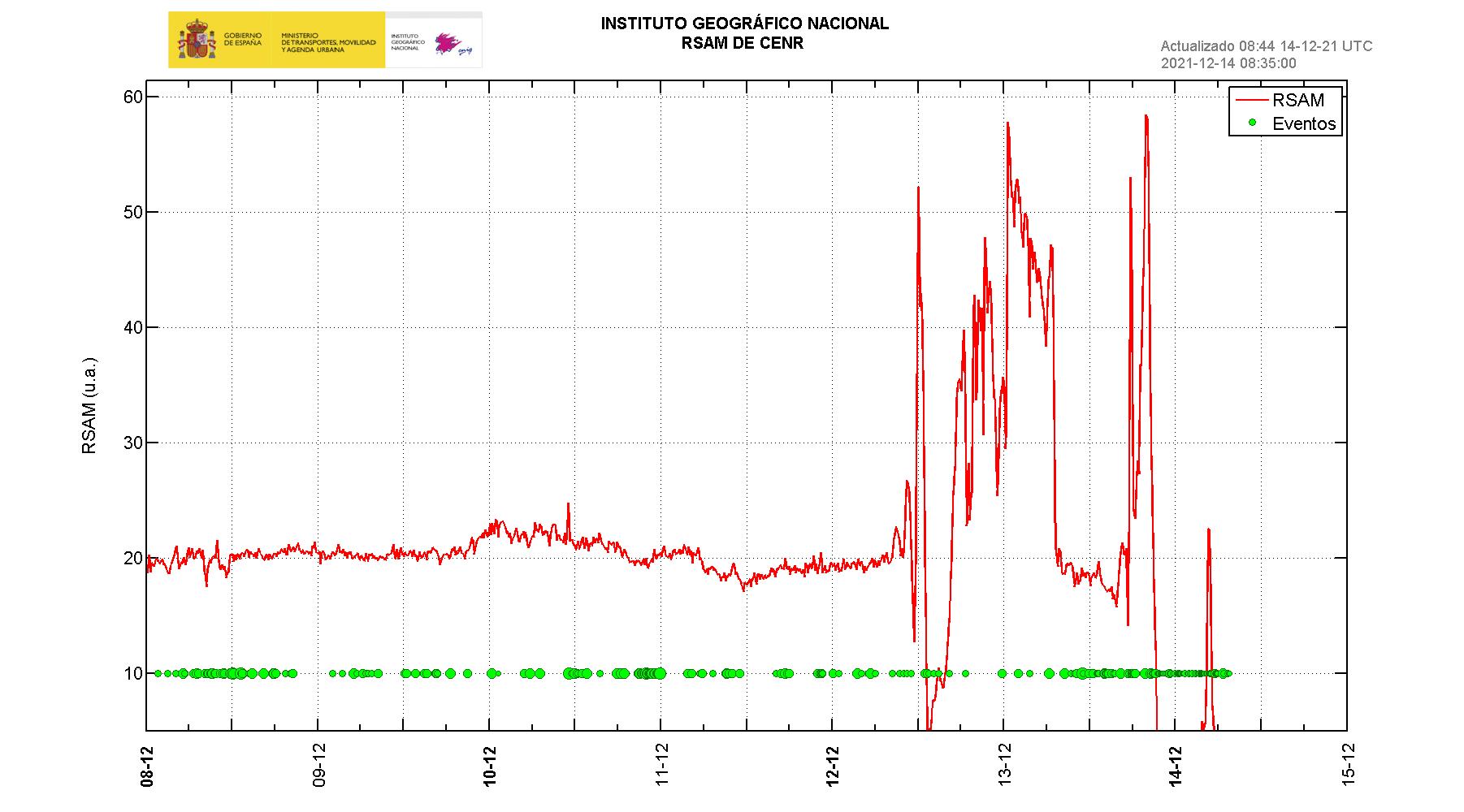
The trend of increasing the average amplitude of volcanic tremor continues in the high value range. The infrasound activity remains low.
Soil deformation monitoring networks have not recorded any significant changes since the last update.
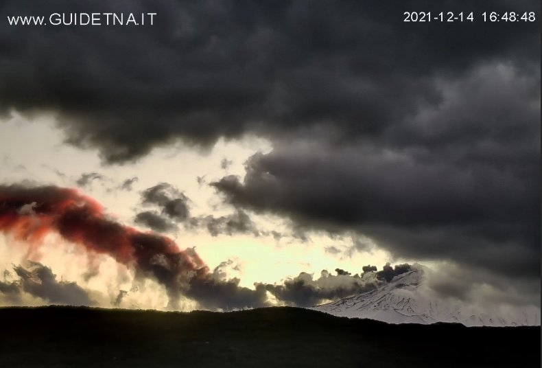
December 14, 2021. 18:44 (17:44 UTC). Press release on ETNA’s activity.
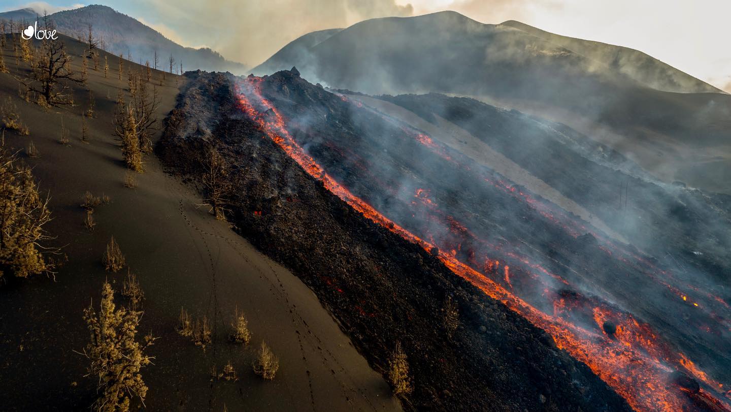
From the images of the CCTV system, it can be seen that the lava flow described in Communication N. 526 is in strong retreat and the position of the front is located a short distance from the effusive vent located at an altitude of 2180 m.
The intense and continuous emission of ash at the level of the Southeast Crater reported in press release n ° 527, continued until approximately 4:15 p.m. UTC. Subsequently, the emission had a variable tendency, alternating from phases in which the matter emitted strongly decreased and was dispersed in the top zone, to phases in which the emission resumed continuously and subsided. scattered to the south.
The average amplitude of the volcanic tremor, after reaching the maximum value around 14:30 UTC, suffered a rapid decrease. Currently, the amplitude of the tremor shows fluctuations around high values. The infrasound activity, on the other hand, does not show significant variations.
The stations of the soil deformation monitoring networks operating on the volcano show no significant changes since the last update.

December 15, 2021 06:41 (05:41 UTC): the images of the CCTV system show that during the night a weak Strombolian activity was observed at the level of the Southeast Crater which produced ash quickly dispersed in the summit area. The lava flow produced by the vent opened at an altitude of 2180 m in the Valle del Bove is still weakly fed
Further updates will be communicated shortly.
Source : INGV.
Photos : Guide Alpine Vulcanologiche Etna , Etna Walk / Giuseppe Distefano / Marco Restivo , Gio Giusa .
Spain / La Palma , Cumbre Vieja :
December 14, 2021, 09:00 UTC. Eruptive activity continues on La Palma.
Since the last announcement, the amplitude of the tremor signal has experienced significant oscillations, ranging from large intensifying pulses to levels similar to those before the eruption. This decrease in the level of tremor, in certain time windows, meant that during these, the locating capacity increased until it was possible to locate earthquakes of lower magnitudes than those of the previous days. . The extent of completeness is therefore subject to temporary variations.
During this period, a total of 129 earthquakes were located on the island of La Palma, at least two of them were felt by the population.
The maximum recorded magnitude is 3.4 mbLg, corresponding to yesterday’s earthquake at 10:58 UTC, 11 km deep and weakly felt. The minimum magnitude of the localized earthquake was 1.1 mbLg.
Seismicity continues below the central area of Cumbre Vieja in the same areas of the previous days, with greater dispersion. Most earthquakes (125) are located at depths between 8 and 16 km. Three earthquakes were also located at depths between 37 and 49 km and one at a depth of 3 km, the latter with a magnitude of 1.4 mbLg.
As yesterday, the network of permanent GNSS stations on the island does not show a clear tendency to deformation of the stations closest to the eruptive centers.
In the rest of the stations, the slight deflation possibly linked to the deep seismicity has stabilized, except in LP01 which continues to record it.
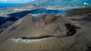
In view of the image calibrated at 08:45 UTC, a maximum scattering cloud height of 2200 m is estimated with a West-South-West direction, with dispersion also towards the East-North-East.
The height of the cone is measured by obtaining a value of 1,123 m at sea level.
The seismologist of the National Geographical Institute, Itahiza Domínguez, underlines the great variability of the tremor of the eruption of the volcano Cumbre Vieja with peaks coinciding with the pulses of volcanic activity. “Right now it is back to minimum values. The activity seems to vary greatly over the past 36 hours, « explains the expert.
The tremor signal on the volcano of La Palma has disappeared since 9:00 p.m. Monday, which does not imply the completion of the eruption, reported the Volcanological Institute of the Canary Islands (Involcan). The tremor, an indicator of the movement of lava below the surface, has ceased on other occasions, but was then followed by a new range of activities. In this case, this is the longest tremor-free interval since the eruption began on September 19. Ithaiza Dominguez, a volcanologist from the National Geographic Institute, indicated on his Twitter account that the volcanic tremor has still practically disappeared since last night. Since then, the seismicity has increased because the absence of tremor makes it possible to locate events of smaller magnitude, underlines the volcanologist.
The sulfur dioxide (SO2) emission recorded yesterday Tuesday (12/14/2021) from 2:00 p.m., from the current eruptive process at Cumbre Vieja, was estimated to be extremely low (<0.06 kg / s or <<5 tonnes per day). The volcano of La Palma ceased all its activity this Tuesday evening. « It does not emit lava, sulfur dioxide, or register any tremor or seismicity signal, » sources from the National Geographic Institute (IGN) confirmed.
Sources : IGN es , El Pais . Involcan .
Photos : IGN , I love the world .
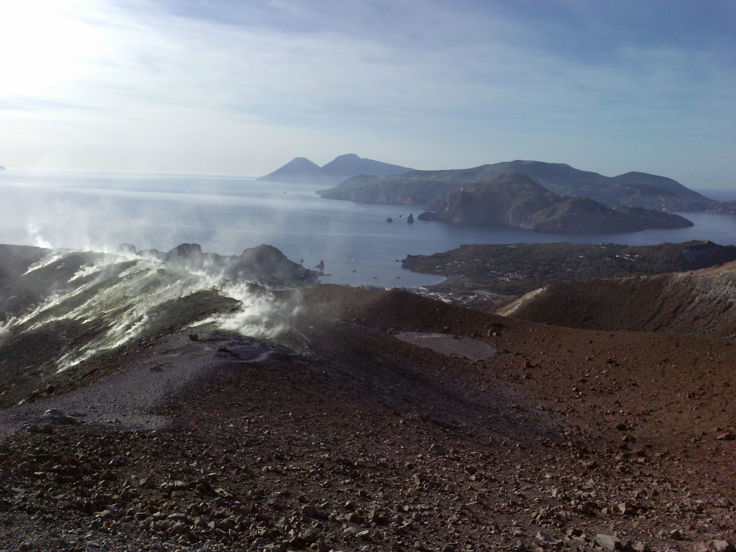
Italy , Vulcano :
WEEKLY NEWSLETTER from December 06, 2021 to December 12, 2021 (issue date December 14, 2021)
SUMMARY STATUS OF THE ACTIVITY:
In view of the monitoring data, it is highlighted:
1) Temperature of the fumaroles of the crater: Temperature values decreasing on the edge of the crater and stable on the internal face.
2) CO2 flux in the crater area: The CO2 flux on the ground in the summit area on a daily average (VCSCS) shows high values around 10,345 g / m2 / day on December 10, 2021, still on an order of magnitude higher than the averages recorded over the past 10 years.
3) SO2 flux in the crater area: SO2 flux: there is no updated data, the data as of December 5 puts the SO2 flux at a high level
4) Geochemistry of fumarolic gases: There is no update.
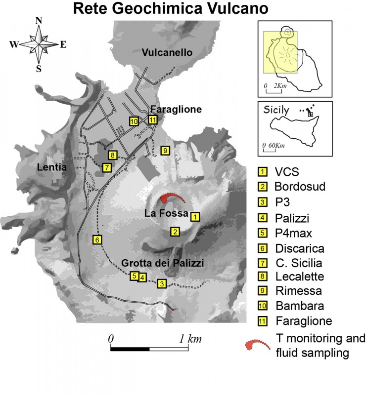
5) CO2 flow at the base of the La Fossa cone and in the Vulcano Porto area: The flow values at the base of the cone automatically acquired by the VULCANOGAS network show a general decrease but remain high values, except of the Faraglione site, where low values are recorded, typical of the bottom level that characterizes this site.
6) Geochemistry of thermal aquifers: Stable temperature and conductivity values in the well of Camping Sicilia. In the Bambara well, a slight increase in the level is observed, while the conductivity values continue to decrease.
7) Local seismicity: The phase of increase in low frequency type events (VLP) continues.
8) Regional seismicity: Weak fracturing seismic activity.
9) Deformations – GNSS: The areal expansion of the IVUG-IVCR-IVLT triangle does not show substantial variations. The IVCR station shows a gradual, albeit modest, increase in the values of the Up and NS components
10) Deformations – Clinometry: The inclination network does not show substantial variations
11) Other observations: GB-RAR: The results of the GB-RAR monitoring referring to the period from December 2 to 13, show a general stability of the area, with deformations along the LOS of less than 1 mm.
Gravimetry: Gravimetric data do not show significant variations attributable to deep mass redistribution phenomena. It should be noted that from the beginning of December, the two stations recorded a large number of transients.
CRATER FUMAROLLES TEMPERATURE:
From November 24, the fumaroles on the edge have a negative gradient. The percentage of validated data is 100% even if the variability is very important, due to the frequent rains of the last days. The continuously monitored temperatures on the inside show a range of values between 98 and 110 ° C. This fumarole resumed a slight positive trend (around 1 ° C / day), after a period of interruption (between 14 and 18 November). However, it is not excluded that the particularly pronounced downward trends recorded around the rim of the crater (fumaroles F5AT and F5) may be determined or accentuated by the heavy rains that have fallen in recent days.
Source : INGV.
Photos : INGV , G Vitton.
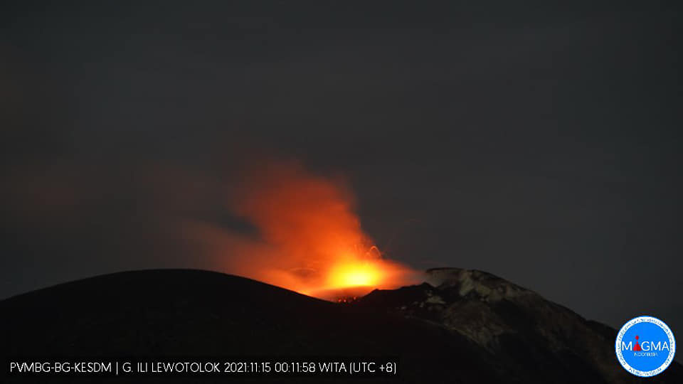
Indonesia , Ili Lewotolok :
VOLCANO OBSERVATORY NOTICE FOR AVIATION – VONA.
Issued : December 13 , 2021
Volcano : Ili Lewotolok (264230)
Current Aviation Colour Code : ORANGE
Previous Aviation Colour Code : orange
Source : Ili Lewotolok Volcano Observatory
Notice Number : 2021LEW57
Volcano Location : S 08 deg 16 min 19 sec E 123 deg 30 min 18 sec
Area : East Nusa Tenggara, Indonesia
Summit Elevation : 4554 FT (1423 M)
Volcanic Activity Summary :
Eruption with volcanic ash cloud at 00h11 UTC (08h11 local). Eruption and ash emission is not continuing.
Volcanic Cloud Height :
Best estimate of ash-cloud top is around 6474 FT (2023 M) above sea level, may be higher than what can be observed clearly. Source of height data: ground observer.
Other Volcanic Cloud Information :
Ash-cloud moving to West and Northwest
Remarks :
Seismic activity is characterized by continuous volcanic tectonic earthquake.
The recorded seismicity showed:
– 21 eruption / explosion earthquakes
– 98 earthquakes of emissions
– 4 hamonic tremors
– 29 non-harmonic tremors
– 1 distant tectonic earthquake
– 4 Continuous tremors earthquakes, amplitude 0.5-14.4 mm (dominant value 10 mm)
Sources : Magma Indonésie , PVMBG.
Photo : Magma Indonésie. ( archive).
Colombia , Nevado del Ruiz :
Bulletin of the activity level of the Nevado del Ruiz volcano.
The activity level continues at: Yellow activity level or (III): changes in the behavior of volcanic activity.
Regarding the monitoring of the activity of the Nevado del Ruiz volcano, the SERVICIO GEOLÓGICO COLOMBIANO reports that:
The seismicity linked to the dynamics of the fluids inside the volcanic conduits showed a decrease in the number of recorded earthquakes and the seismic energy released compared to the previous week. This seismic activity was characterized by the appearance of continuous volcanic tremor, tremor pulses, earthquakes of long types and very long periods, which exhibited moderate energy levels and variable spectral content. These earthquakes were located mainly in the Arenas crater. Some of these signals were associated with ash emissions, confirmed by cameras installed in the area of the volcano and by the report of officials of the Colombian Geological Service and Los Nevados National Natural Park.

The seismicity generated by rock fracturing increased in number of earthquakes and decreased in seismic energy released compared to the previous week. This seismic activity was located mainly in the South-South-East, North-East, South-West and West sectors of the volcano and in the Arenas crater. The depths of the earthquakes ranged from 0.3 to 8.8 km. The maximum magnitude recorded during the week was 1.2 ML (Local Magnitude) corresponding to the earthquake recorded on December 8 at 08:26 (local time), located 5.2 km northwest of the Arenas crater, at a depth of 3.9 km.
Source : SGC.
Photo : SGC / José Fabio Gomez Mejia.