December 08 , 2021.
Italy : Vulcano ;
WEEKLY NEWSLETTER, WEEK from November 29, 2021 to December 05, 2021. (issue date December 07, 2021)
SUMMARY OF ACTIVITY STATUS
In view of the monitoring data, it is highlighted:
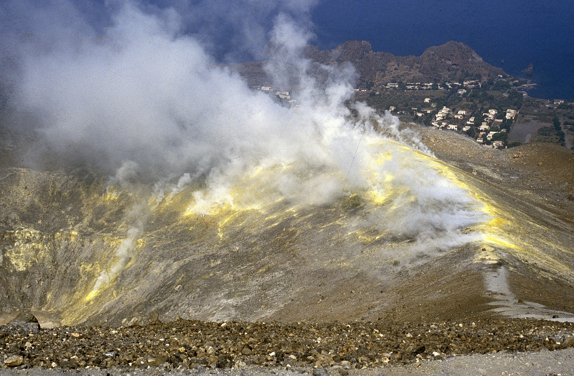
1) Temperature of the fumaroles of the crater: Temperature values appreciably stable at the same time on the edge and on the internal face, except for the site F5, where a strong decrease is observed.
2) CO2 flux in the crater area: The CO2 flux values, while remaining at high values (9070 g / m2 / day), show a decreasing trend.
3) SO2 flow in the crater area: SO2 flow appears at a high level
4) Geochemistry of fumarolic gases: There is no update.
5) CO2 flow at the base of the La Fossa cone and in the Vulcano Porto area: The flow measurements at the base of the cone acquired automatically by the VULCANOGAS network remain stable at high values.
On the Palizzi site (P4max) the flow values show a clear downward trend.
6) Geochemistry of thermal aquifers: Stable temperature and conductivity values in the well of Camping Sicilia. In the Bambara well, there is a slight increase in level, while the conductivity values continue to drop.
7) Local seismicity: Significant increase in low frequency events (VLP).
8) Regional seismicity: Weak fracturing seismic activity.
9) Deformations – GNSS: During the last week, a slight increase in the expansion of the area continues.
10) Deformations – Clinometry: The inclinometric data do not show significant variations
11) Other observations: Localized gravity variations at the continuous station of VSOCR and VCARA are recorded. There are no variations attributable to significant phenomena of deep mass redistribution.
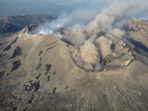
CRATER FUMAROLLES TEMPERATURE.
For the current week (30 November 6 December) the maximum temperature emission (fumarole F5AT) showed measurements in the range 223-353 ° C with a positive trend. As of November 24, however, F5 fumarole shows a negative gradient, losing more than 100 ° C at the point of emission (calculated linear trend = -4.73 ° C / day). The temperatures continuously monitored on the slope inside the cone show a range of values between 98 and 110 ° C. This fumarole (FA) resumed a slight positive trend (around 1 ° C / day), after a period of interruption (between 14 and 18 November).
CO2 FLOWS AT THE BASE OF THE CONE DE LA FOSSA AND IN THE PORTO VULCANO AREA
The CO2 fluxes from the soil (continuous) in the sites of Rimessa, Camping Sicilia, remain stable, at very high values throughout the last week. On the Palizzi site (P4max) a strong decrease in CO2 flows was observed. At the Faraglione site, after the sharp drop last week, there is a new upward trend; the flow values recorded on this site last week, however, fit into the typical context of this site.
Source : INGV.
Photo : G. De Astis (INGV-Rome1) , Boris Behncke .
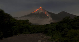
Spain / La Palma , Cumbre Vieja :
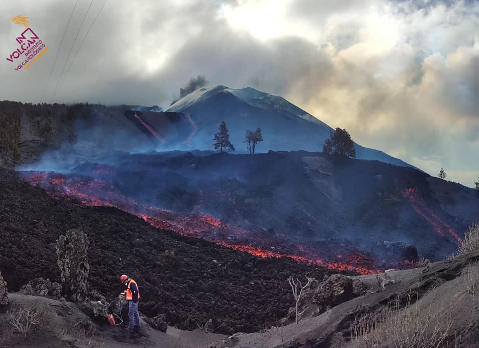
07 December 2021 10:00 UTC. Eruptive activity continues on La Palma
Since the last declaration, a total of 35 earthquakes have been located on the island of La Palma, only one of which was felt by the population.
The maximum recorded magnitude is 3.5 (mbLg) corresponding to yesterday’s earthquake at 11:41 UTC, with a depth of 10 km.
The seismicity continues under the central area of Cumbre Vieja in the same areas of the previous days, most of the earthquakes (28) are located at depths between 10 and 15 km. Two surface earthquakes were also recorded in the area near the volcanic building (western sector).
The amplitude of the tremor signal remains at low levels and is just as stable as the previous days.
As in previous days, the island’s network of permanent GNSS stations does not show a clear trend in the deformation of the stations closest to the eruptive centers.
In the rest of the stations, the slight deflation possibly linked to the deep seismicity has stabilized, except in LP01 which continues to record it.
In view of the image calibrated at 08:00 UTC, an ash cloud height of 3000 m is estimated in a northeast direction.
The height of the cone is measured by obtaining a value of 1,123 m at sea level.

The lava flow that emerged west of Montaña Cogote, which falls through the cliff in the Las Hoyas region and overflows into the lower part of the lava delta, devastated 60 buildings in 36 hours, media reported the director of Pevolca, Miguel Ángel Morcuende, and the volcanologist of the National Geographic Institute (IGN), Carmen Lopez. In the daily press conference, López detailed that the eruption actively continues west of the main cone, with lava flowing through a volcanic tube and several offshoots and moving westward on previous flows, with a front which overflowed towards the South-East on previously untouched areas, until reaching that of Montaña Cogote. López pointed out that these are ephemeral flows associated with the surface feed system, very fluid, high temperature and moving rapidly, degassed, but last only « a few hours. »
Sources : IGN es , El Pais .
Carte : Volcanes y Ciencia Hoy
Photo : Involcan.
Indonesia , Semeru :
VOLCANO OBSERVATORY NOTICE FOR AVIATION – VONA.
Issued : December 07 , 2021
Volcano : Semeru (263300)
Current Aviation Colour Code : ORANGE
Previous Aviation Colour Code : orange
Source : Semeru Volcano Observatory
Notice Number : 2021SMR82
Volcano Location : S 08 deg 06 min 29 sec E 112 deg 55 min 12 sec
Area : East java, Indonesia
Summit Elevation : 11763 FT (3676 M)
Volcanic Activity Summary :
Pyroclastic flow occured from the edge of lava deposit at 17h01 UTC ( 00h01 local )
Volcanic Cloud Height :
Best estimate of ash-cloud top is around 13363 FT (4176 M) above sea level, may be higher than what can be observed clearly. Source of height data: ground observer.
Other Volcanic Cloud Information :
Ash-cloud moving to north
Remarks :
Lava flow is observed through the North direction of the Semeru summit crater.
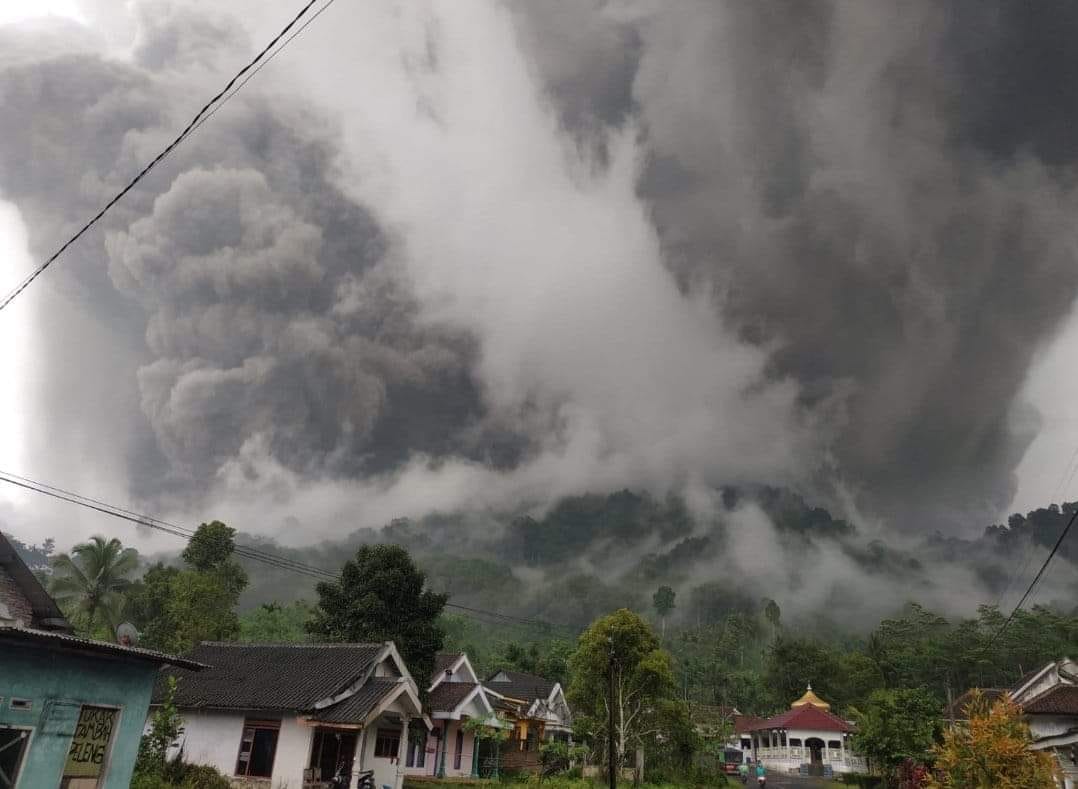
The volcano was clear to hazy. Lava avalanches were observed with a sliding distance of 500 m from the tip of the lava tongue (lk 700 m from the crater) towards Curah Kobokan.
There are volcanic earthquakes linked to eruptions, hot avalanche clouds, lava avalanches, smoke emissions from the crater, magmatic activity and flood tremors.
– 3 eruption / explosion earthquakes
– 4 hot cloud avalanche earthquakes
– 9 avalanche earthquakes
– 15 earthquakes of emissions
– 8 harmonic tremors
– 2 deep volcanic earthquakes
– Flood vibrations
The public / visitors / tourists must not have activities within a radius of 1 km around the crater / peak of Mount Semeru and at a distance of 5 km towards the opening of the crater in the South-South-East sector. Watch out for hot cloud avalanches, lava avalanches, and lahars along the rivers / valleys that originate at the top of Mount Semeru.
Sources : Magma Indonésie , PVMBG.
Photo : Flash Ouragans Météo Antilles via Marc Szeglat.
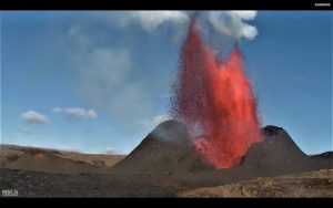
Hawaii , Kilauea :
19°25’16 » N 155°17’13 » W,
Summit Elevation 4091 ft (1247 m)
Current Volcano Alert Level: WATCH
Current Aviation Color Code: ORANGE
Activity Summary:
Kīlauea volcano is erupting from a single vent in the western wall of Halemaʻumaʻu crater as of this morning, December 7, 2021. Lava re-entered the vent and resumed erupting between 5:30 and 6:00 PM HST last night, ending the pause that began on the afternoon of Friday, December 3. All recent lava activity remains confined within Halemaʻumaʻu crater in Hawai‘i Volcanoes National Park.
Summit Observations:
The eruption of lava restarted from the western vent in Halema‘uma‘u crater the evening of Monday, December 6, at approximately 5:30 PM. By 6 PM, lava was flowing out from the vent. Both ground inflation and tremor (a seismic signal associated with magma movement) peaked around 9 PM last night. Summit tiltmeters have shown deflation since then and earthquake activity remains below background.
The most recent measurement of sulfur dioxide (SO2) emission rates on November 29, 2021 was approximately 1200 tonnes per day. No new measurements have been made due to recent weather conditions.
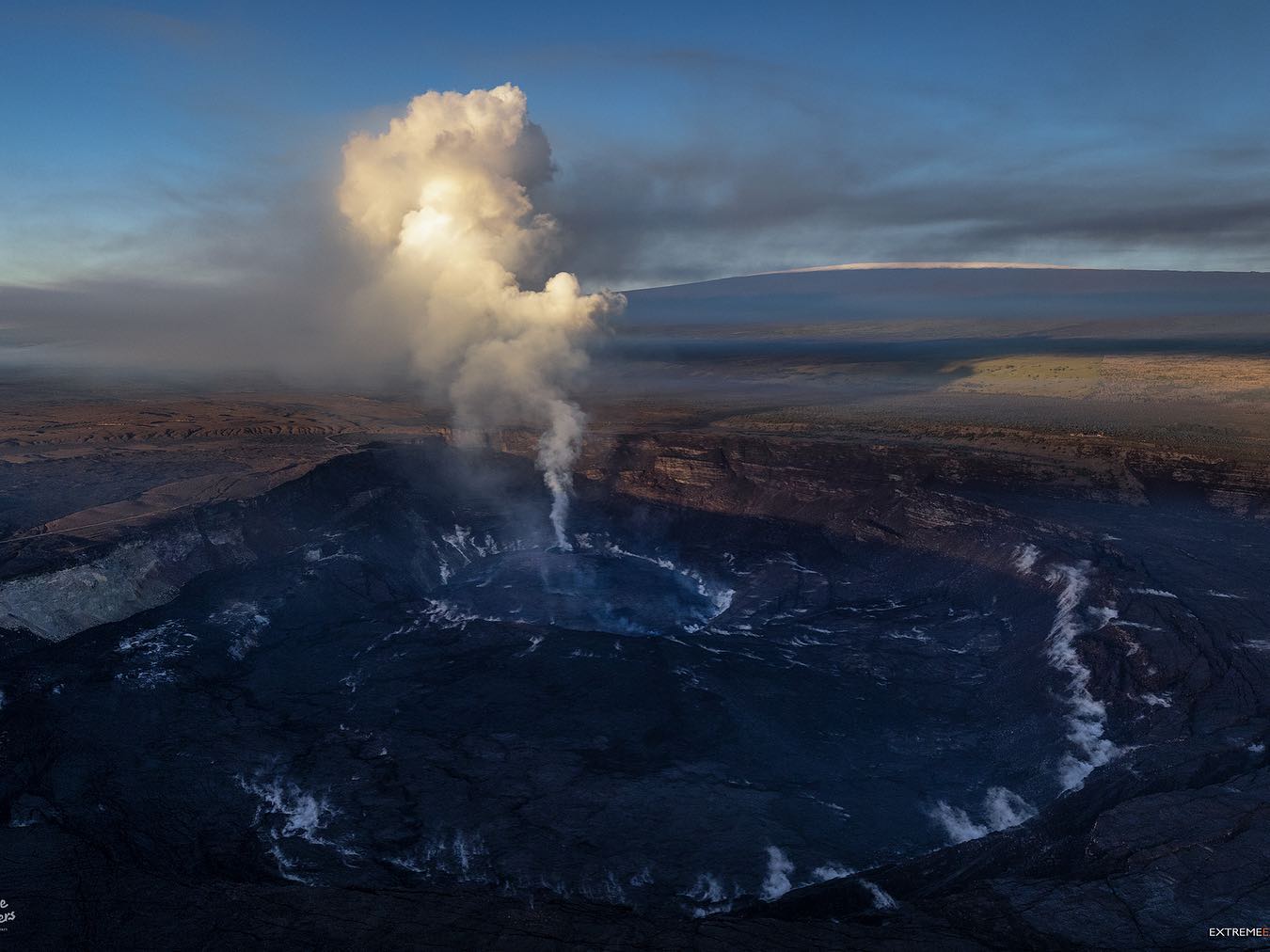
Halemaʻumaʻu Lava Lake Observations:
Lava has resumed erupting from a single vent in the western wall of Halemaʻumaʻu crater after a 3 day pause in activity. Friday afternoon, the rate of lava eruption from the western vent decreased sharply along with a dramatic reduction in tremor and the start of deflationary tilt. Lava re-emerged from the vent at about 6 PM last night and had covered the prior extent of the active lava lake by about 3 AM this morning, December 7, 2021. The eastern edge of the lake that advanced onto the lowest of the exposed down-dropped caldera floor blocks remains stagnant. This is the fourth and largest such decrease in eruption vigor or pause since the eruption began on September 29 and none of the prior events lasted more than 24 hours before eruptive activity resumed. The western end of the lake has shown little change in maximum elevation over the prior several days, with HVO’s permanent laser rangefinder showing an elevation of approximately 809 meters (2654 ft) prior to the instrument going off-line on December 3 due to weather-related events. The lake has seen a total increase of about 65 meters (213 ft) since lava emerged on September 29. Webcams have shown spatter and ponded lava within the west vent, an area of active lava at the surface of the lava lake, and sporadic oozes of lava along the cooler outer lake margins. The total erupted volume since the beginning of the eruption was estimated to be about 30 million cubic meters (7.8 billion gallons) on November 16.
Source : HVO.
Photo : Bruce Omori .
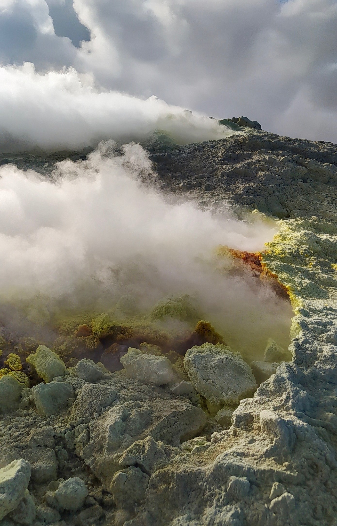
Italy / Sicily , Etna :
WEEKLY NEWSLETTER, WEEK from November 29, 2021 to December 05, 2021. (issue date December 07, 2021)
SUMMARY OF ACTIVITY STATUS
In view of the monitoring data, it is highlighted:
1) VOLCANOLOGICAL OBSERVATIONS: Emission of volcanic ash at the Northeast Crater, Strombolian activity and emission of volcanic ash at the Southeast Crater, degassing activity at the other summit craters.
2) SEISMOLOGY: Seismic activity of weak fracturing, amplitude of the tremor at medium and medium-high levels.
3) INFRASONS: Low infrasound activity
4) SOIL DEFORMATIONS: The soil deformations measured by GNSS and inclinometric networks have not shown significant changes during the last week
5) GEOCHEMISTRY: The flow of SO2 appears at an average level. The flow of CO2 emitted by soils recorded by the EtnaGAS network last week shows a downward trend, settling on average values.
The partial pressure of CO2 dissolved in water shows a decrease even though it is at average levels.
The isotope ratio of helium is placed on medium-high values, (latest data from 08/11/2021) slightly lower compared to the previous values.
There are no updates for the C / S report.
6) SATELLITE OBSERVATIONS: The thermal activity in the summit area was moderate in correspondence with the Strombolian activity of the Southeast Crater on November 4-5.
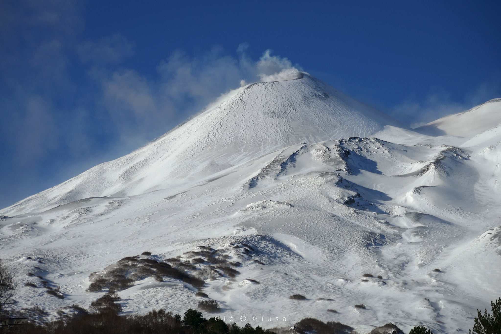
VOLCANOLOGICAL OBSERVATIONS
During the week, the monitoring of the volcanic activity at the level of the summit craters of Etna was carried out by analyzing the images of the surveillance cameras of the INGV, Etneo Observatory (INGV-OE) and by the observations made. by INGV-OE staff. .
The bad weather conditions made the observation of the volcanic activity discontinuous thanks to the network of cameras. During the period under review, summit craters were characterized by light and discontinuous volcanic ash emissions at the Northeast Crater (NEC), Strombolian activity, and light and discontinuous volcanic ash emissions at the Southeast Crater (SEC) and by a weak degassing activity at the crater of Voragine (VOR) and Bocca Nuova (BN).
On December 1, the Northeast Crater (NEC) was characterized by light and discontinuous emissions of volcanic ash. Analysis of the images from the INGV-OE cameras showed that the volcanic ash quickly dispersed near the summit crater area.
On the morning of December 4, light and sporadic volcanic ash emissions were observed towards the Southeast Crater (SEC), both by INGV-OE personnel present in the summit area and via the network of cameras. INGV – OE. During the afternoon, the analysis of the images from the cameras highlighted the presence of Strombolian activity at the Southeast Crater (SEC). This activity also continued on December 5 with light and sporadic emissions of volcanic ash which dispersed into the atmosphere mainly in the summit area.
Finally, the Voragine crater and the Bocca Nuova crater were characterized by low degassing activity.
Source : INGV.
Photo : Gio Giusa . ( cratère du Nord-Est ).