Décember 01 , 2021.
Philippines , Pinatubo :
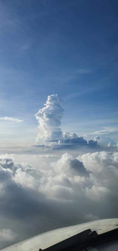
Based on visual evidence collected from an eruption plume as well as recorded data from seismic, infrasound and satellite monitoring, DOST-PHIVOLCS confirmed that a phreatic eruption had occurred in the Pinatubo crater at 12:09 p.m. at 12:13 today. This also took place after AFP sorted the information on the state of the volcano in the northern part of Pinatubo this morning. So far, there have been no reports of ash fall from the communities of Zambales where the plume from the eruption drifted. If we look at the low number of volcanic earthquakes in recent days, as well as the diffuse volcanic CO2 flux measured in November 2021 in the crater lake of Pinatubo, and the infrasound energy higher than the seismic signal of the previous event, the phreatic eruption was most likely caused by shallow hydrothermal processes in the volcano.
The DOST-PHIVOLCS reminds the public to avoid approaching the Pinatubo volcano during this period. Local governments are urged to ban entry into Pinatubo Crater first as sudden phreatic or hydrothermal explosions could occur without warning. Surrounding communities and local governments are reminded to always be prepared against the dangers of earthquakes and volcanic eruptions and to reassess, prepare and approve their contingency plans, and other disaster preparedness plans. DOST-PHIVOLCS continues to strengthen volcanic monitoring by expanding the Pinatubo volcanic network and carrying out frequent geochemical surveys of the Pinatubo crater, as well as monitoring soil deformation using GPS and satellite data. Currently, the state level of Pinatubo, which is at alert level 0, is being assessed as well as the future results of the processing of GPS and InSAR data.
DOST-PHIVOLCS continues to closely monitor the state of the Pinatubo volcano and any changes will be immediately communicated to all concerned.
Source : Phivolcs.
Photo : CNN Philippines / AirAsia Captain Aljess Lasmarias
Italy / Sicily , Etna :
Weekly bulletin from November 22, 2021 to November 28, 2021 (issue date November 30, 2021)
SUMMARY OF ACTIVITY STATUS
In view of the monitoring data, it is highlighted:
1) VOLCANOLOGICAL OBSERVATIONS: Degassing activity of summit craters.
2) SEISMOLOGY: Absence of seismic fracturing activity with Ml> = 2.0; amplitude of the volcanic tremor in the middle level
3) INFRASOUND: medium to low infrasound activity.
4) DEFORMATIONS: The deformations of the ground measured by the GNSS and inclinometric networks did not show any significant changes during the last week.
5) GEOCHEMISTRY: The flow of SO2 is placed at an average level.
The flow of CO2 emitted by soils recorded by the Etna GAS network last week is at average values.
The partial pressure of CO2 dissolved in water shows a slight increase even though it is at medium levels.
There is no update for the helium isotope ratio, the latest data from October 20, 2021 is set to medium to high values.
There are no updates for the C / S report.
6) SATELLITE OBSERVATIONS: The thermal activity in the summit area was at a low level.
VOLCANOLOGICAL OBSERVATIONS
The monitoring of the volcanic activity of Etna during the week in question was carried out thanks to the analysis of images of the network of surveillance cameras of the INGV, Osservatorio Etneo (INGV-OE). The bad weather conditions made the observation of the volcanic activity discontinuous thanks to the network of cameras.
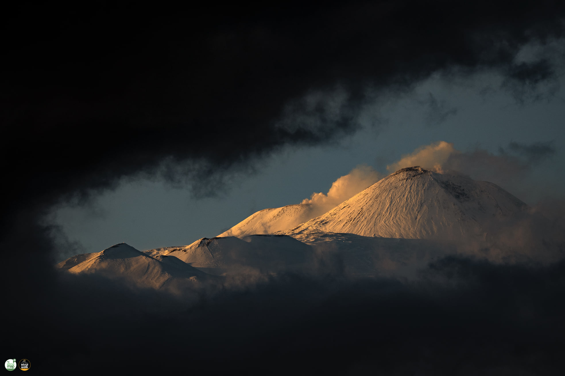
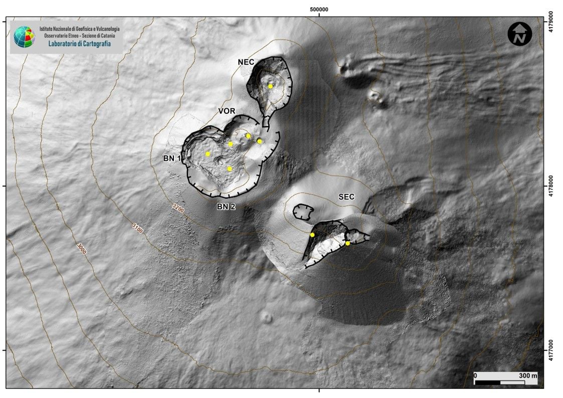
During the observation period, the activity at the summit craters showed no change from what had been observed the previous week and was characterized by a variable degassing regime dominated mainly by the crater of the Bocca Nuova.
Volcanic tremor:
During the week in question, the average amplitude of the volcanic tremor showed oscillations in the range of average values.
The location of the source of the tremor is in the area of the Bocca Nuova crater, at an altitude of between 2,500 and 3,000 meters above sea level.
Source : INGV.
Photo : Etnawalk.
Spain / La Palma , Cumbre Vieja :
November 30, 2021, 09:00 UTC. Eruptive activity continues on La Palma.
Since the last declaration, a total of 259 earthquakes have been located in the area affected by the volcanic reactivation on the island of La Palma, of which 14 were felt by the population.
Seismicity continues under the central area of Cumbre Vieja in the same areas of the previous days, 246 of these earthquakes are located at depths of 10 to 15 km and the rest (13) at depths of 20 km.
The maximum recorded magnitude is 4.1 (mbLg) corresponding to today’s earthquake at 6:42 UTC, with a depth of 38 km.
The amplitude of the tremor signal was maintained at low levels with intensifying pulses.

The network of permanent GNSS stations on the island does not show a clear trend in the deformation of the stations closest to the eruptive centers.
In the rest of the stations, the slight deflation possibly linked to the deep seismicity has stabilized, except in LP01 which continues to record it.
In view of the image calibrated at 08:45 UTC, a column height of 2,600 m is estimated, and a cloud is diffusing in a south-southwest direction.
The height of the cone is measured by obtaining a value of 1.125 m on sea level.
Today at 10:55 UTC, due to the increase in the height of the volcanic ash cloud, the IGN issued a new VONA (Volcano Observatory Notice for Aviation) message communicating that the maximum height of the eruptive column is 3500 m on sea level.
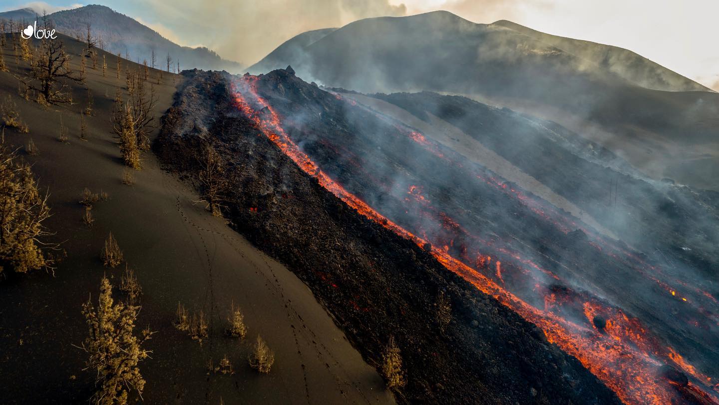
The National Geographic Institute (IGN) recorded more than 120 earthquakes on Tuesday, including around 30 above magnitude 3. The main cone of the volcano returned to emit ash after several hours without doing so, reports the Institute. volcanology of the Canary Islands. Meanwhile, the secondary cone continues to emit pyroclasts and lava, and in the early hours of the morning have had several landslides associated with occasional overflows.
Lava from the Cumbre Vieja volcano in La Palma has already destroyed 1,548 buildings, according to the land register, 64 more than the last count. Of these, 1,242 are for residential use, 169 for agricultural purposes, 69 for industrial purposes, 37 for recreation and hospitality, 15 for public purposes and 16 for other purposes.
The National Geographic Institute (IGN) recorded more than 330 earthquakes in 24 hours on Tuesday, surpassing the record for daily tremors since the start of the eruption. The main cone of the volcano reactivated to emit ash after several hours without doing so, reports the Canary Islands Volcanological Institute. During this time, the secondary cone continues to emit pyroclasts and lava and in the early morning there were several landslides associated with occasional overflows.
Source : IGNes , El Pais .
Photo : UME, I Love the world.
Italy , Vulcano :
Weekly bulletin from November 22, 2021 to November 28, 2021 (issue date November 30, 2021)
SUMMARY OF THE STATUS OF THE ACTIVITY.
In view of the monitoring data, it is highlighted:
1) Temperature of the fumaroles of the crater: Temperature values appreciably stable both on the edge and on the internal face, in line with those of the previous week.
2) CO2 flux in the crater area: Values increasing on very high and abnormal levels (13,290 g / m2 / day)
3) SO2 flux in the crater area: SO2 flux appears at a high level
4) Geochemistry of fumarolic gases: In the sampling of 11/18 the concentrations of magmatic species are placed on average levels, in sharp decline compared to the October sampling.

5) CO2 flow at the base of the La Fossa cone and in the Vulcano Porto area: The flow measurements at the base of the cone acquired automatically by the VULCANOGAS network remain stable at high values.
It was only at the Faraglione site that the throughput values showed a sharp drop.
6) Geochemistry of thermal aquifers: Stable temperature and conductivity values in the well of Camping Sicilia. In the Bambara well, there is a slight increase in the level, while the conductivity values continue to drop.
7) Local seismicity: The phase of local seismicity reduction continues, with particular reference to low frequency events (VLP).
8) Regional seismicity: Low-level fracturing seismicity: 1 single earthquake with Ml = 1.7
9) Deformations – GNSS: During the last week, the increase in expansion of the area continues.
10) Deformations – Inclinometry: From November 20 the uprising towards the northern sector of La Fossa resumed.
11) Other observations: Gravimetry: local and rapid gravimetric variations are recorded due to very superficial and localized sources. There are no variations attributable to significant phenomena of deep mass redistribution.
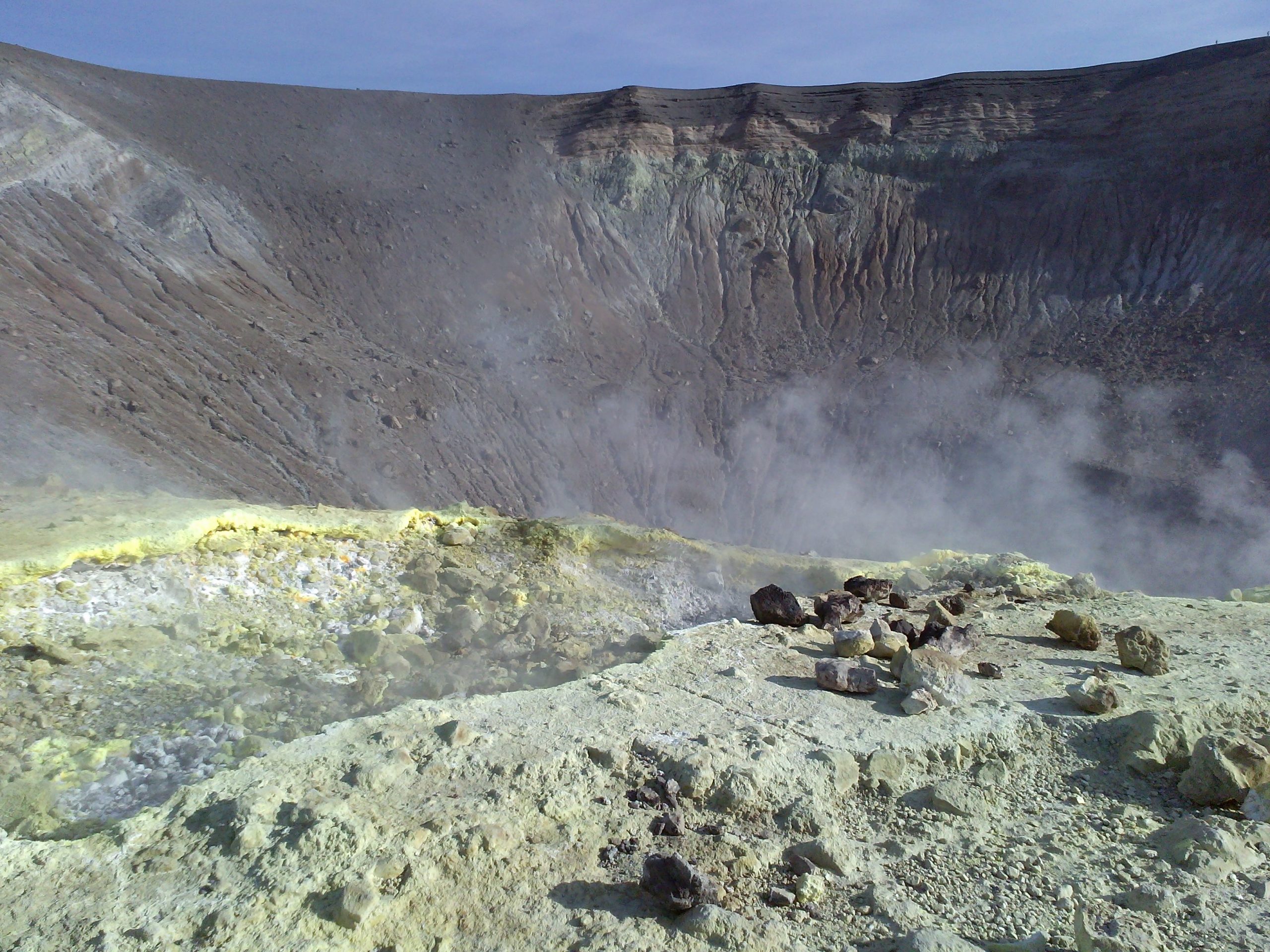
CRATER FUMAROLLES TEMPERATURE.
For the current week (22-29 November), the maximum temperature emission (fumarole F5AT) showed measurements in the range 242-365 ° C and a positive trend. From the 24
November, on the other hand, the F5 fumarole has a negative gradient. The percentage of validated data is 100% for the sensors on the edge of the crater. The F5AT fumarole has a range of values between 291 and 330 ° C.
The continuously monitored temperatures on the inside show a range of values between 98 and 110 ° C. This fumarole resumed the positive trend, not very pronounced, after a period of
interruption (between November 14 and 18).
SO2 FLOW INTO THE CRATER ZONE
The total flux of SO2 emitted by the fumarolic field of Vulcano measured by the network of FLAME-DOAS scanners, since mid-September has indicated values at a high level and above the
degassing of typical Vulcano SO2 streams (20-30 t / d). The average daily values recorded during the last week are stable with the values observed over this period of ~ 110 t / d. From November we can observe the stop of the increase recorded since the beginning of the disturbances and the stabilization of the flow at a high level.
Source : INGV.
Carte : INGV
Photo : G. V.
Alaska , Semisopochnoi :
51°55’44 » N 179°35’52 » E,
Summit Elevation 2625 ft (800 m)
Current Volcano Alert Level: WATCH
Current Aviation Color Code: ORANGE
Low-level eruptive activity continues at Semisopochnoi volcano. Episodic bursts of seismic tremor were detected in seismic data and a few minor explosions were recorded by infrasound sensors over the past day. Minor ash and steam emissions were observed in web camera images over the past day. A small ash cloud was observed in satellite data early this morning about 33 km (20 mi) northeast of Semisopochnoi Island. The ash cloud dissipated quickly and probably did not extend more than 1000-2000 ft above sea level.
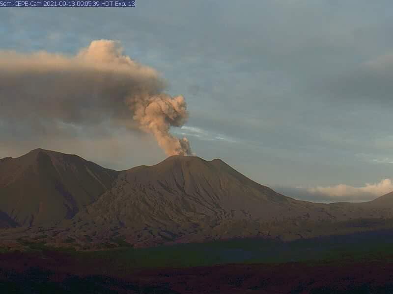
Small eruptions producing minor ash deposits within the vicinity of the active north crater of Mount Cerberus and ash clouds usually under 10,000 ft above sea level have characterized the recent activity. Small explosions may continue to occur and could be difficult to detect, especially during poor weather conditions.
Semisopochnoi is monitored by local seismic and infrasound sensors, satellite data, web cameras, and remote infrasound and lightning networks.
Source : AVO
Photo : Archive USGS.
Saint Vincent : Soufrière Saint Vincent :
ERUPTIVE PHASE ENDS AT LA SOUFRIЀRE VOLCANO
Tuesday, November 30, 2021. — Scientists attached to The UWI Seismic Research Centre (UWI-SRC) have ended their tour of duty in St. Vincent and the Grenadines
Activity at the volcano has declined steadily since the last explosive event on April 22nd, 2021 and all currently available monitoring data points to an end in eruptive activity. However, residual steaming at the summit and lahars (mudslides) in the valleys surrounding the volcano will continue to be observed for some time. The Soufriѐre Monitoring Unit (SMU) at the National Emergency Management Agency will now assume responsibility for the operations of the Belmont Observatory. Day to day monitoring of the volcano will be supported by the UWI-SRC remotely from its base in Trinidad.
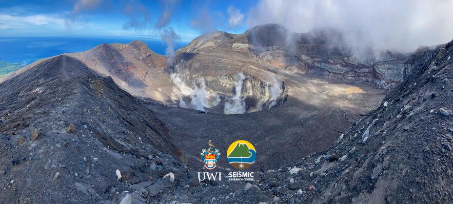
The on-island scientific staff rotation ends an almost year-long occupation of the Belmont Observatory. After the detection of the new lava dome at La Soufriѐre in late December 2020, UWI-SRC scientists based at the observatory oversaw the upgrade of the local seismic and ground deformation monitoring networks, conducted other fieldwork and ground-based measurements, and advised the Government of St. Vincent and the Grenadines in the run up to the onset of explosive activity on April 9th, 2021.
Senior Research Fellow (Geologist) at the UWI-SRC, Prof. Richard Robertson believes that the volcano will now go through a period of adjustment saying: “The mountain went through a traumatic experience and will take some time to reshape itself”. UWI-SRC Director, Dr. Erouscilla Joseph reaffirms the Centre’s commitment to St. Vincent and its residents indicating that “we continue to monitor La Soufrière in this new phase of activity and provide support to NEMO and the Government of St. Vincent and the Grenadines”.
The volcanic alert level at La Soufriѐre remains at YELLOW.
Source et photo : UWI Saint-Augustin, Trinité-et-Tobago.