October 10 , 2021.
Spain / La Palma , Cumbre Vieja :
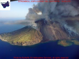
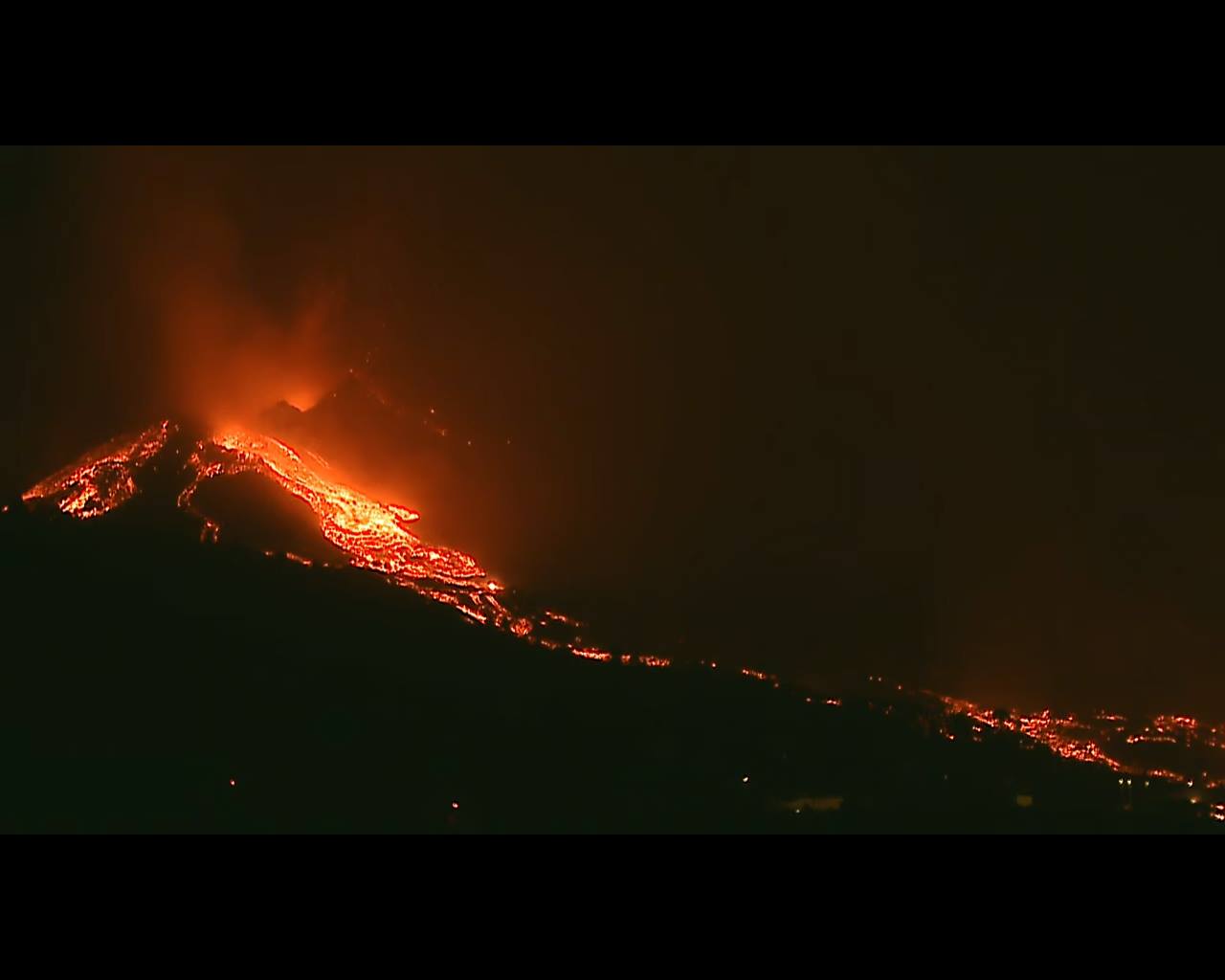
The north side of the cone of the Cumbre Vieja volcano in La Palma collapsed early this Saturday morning, causing lava flow in several directions, reports Itahiza Dominguez of the Canary Islands Volcanological Institute (Involcan). The National Geographic Institute (IGN) located 37 seismic movements during dawn, the largest of which, recorded at Fuencaliente at a depth of 14 kilometers, reached a magnitude of 4.1. The ash cloud caused by the volcano has turned south, according to the latest report from the Volcanic Ash Advisory Centers (VAAC) in Toulouse. All airports in the Canary Islands except La Palma are operating without incident and, according to forecasts, will remain so throughout the day on this Saturday.
The marine plume generated by the meeting of lava with the sea should not be underestimated, but should not cause alarm either. The thermal shock between lava (around 1,200 ° C) and seawater (around 24 ° C) essentially generates water vapor (white cloud) and hydrochloric acid (HCL). It is suggested to pay special attention to the wind forecast to monitor possible changes in plume direction and act accordingly. Emergency services working within 1 km of the delta should wear goggles and gas masks. Eye washing is also recommended after any exposure, as symptoms are often not seen until later.
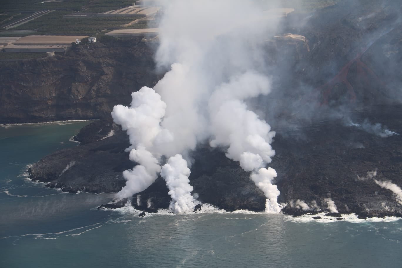
A measurement of the emission of hydrochloric acid (HCl) by the marine plume was carried out on Wednesday October 6 by the use of a remote optical sensor of the OP-FTIR type. The recorded emission rate was 0.5 kg per second, or 43.2 tonnes per day.
Several collapses on the north face of the La Palma volcano accelerate the flow of lava flows
The north face of the eruption cone of the Cumbre Vieja volcano in La Palma suffered a series of collapses in the early hours and afternoon of Saturday, which implied that the lava from the crater dispersed in several directions and accelerated their speed, sources confirmed at the Canary Islands Institute of Volcanology (Involcan) and the Geological and Mining Institute of Spain (IGME). This new lava flow « follows its own path inside the exclusion zone », in the words of the volcanologist and spokesperson for the scientific committee of the Canary Islands Volcanic Emergency Plan (Pevolca), Maria José Blanco .
La Palma airport is resuming activity, Aena reports, although clean-up work continues in areas that are not yet operational.
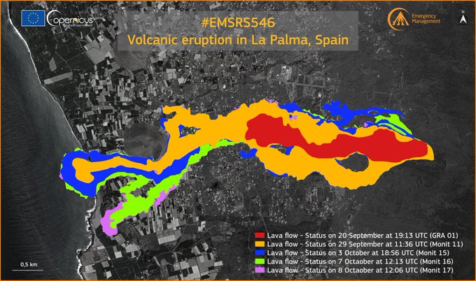
Copernicus updated on Saturday afternoon the mapping of the area affected by the ‘Cumbre Vieja’ volcano in El Paso (La Palma). Lava has already covered a total of 497 hectares since the eruption began on September 19, affecting or destroying 1,281 buildings and infrastructure so far.
Of the 1,281 infrastructure damaged by lava, 1,186 were destroyed and 95 were damaged; while 497 hectares of land covered and an additional 5,576 hectares may have been damaged. Regarding roads, 38.3 kilometers of destroyed tracks and 3.1 kilometers could be damaged.
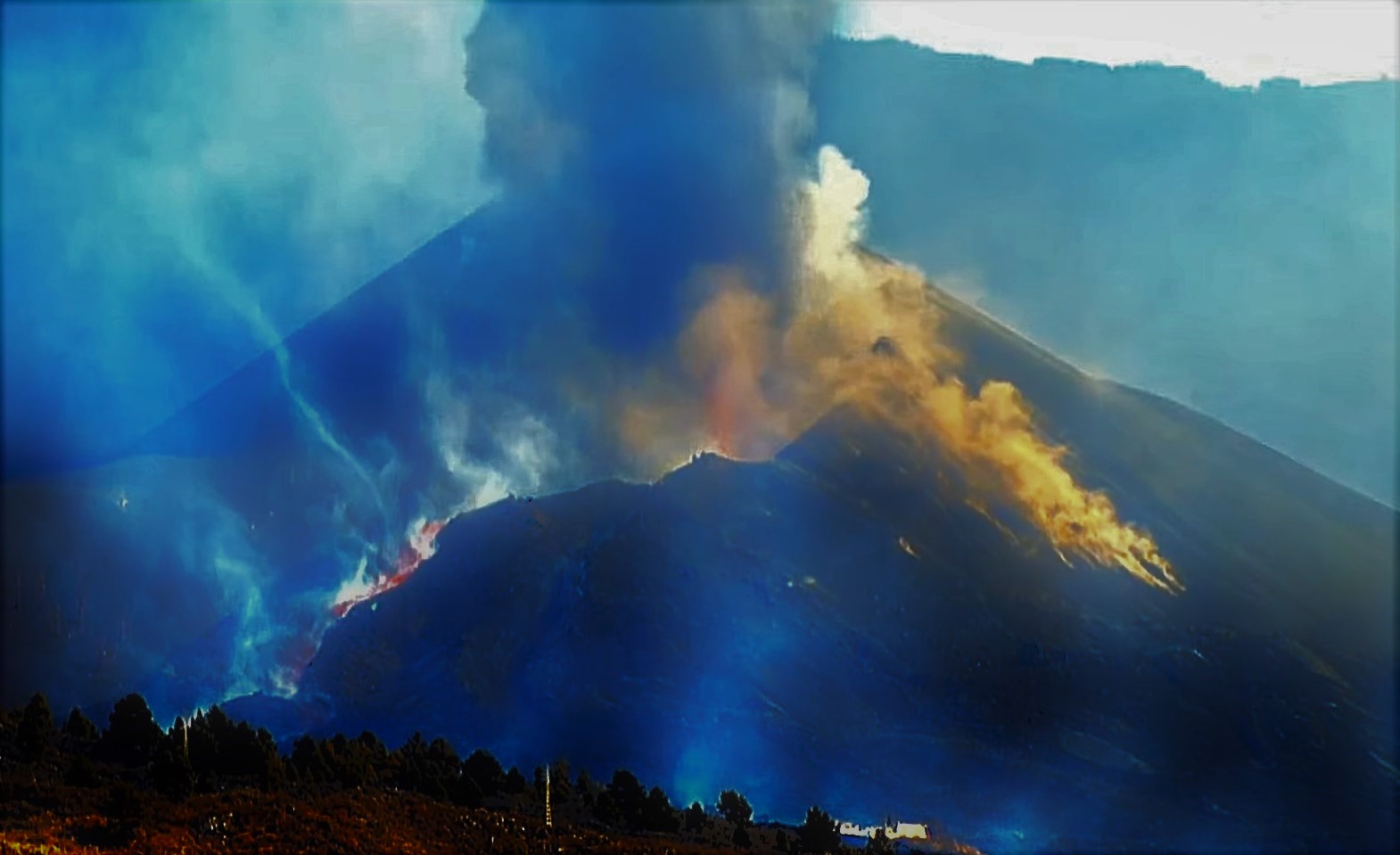
The branch of the southern flow of the volcano of La Palma is currently back, but it is growing in thickness, so that it could advance towards the sea (in a currently undetermined period of time) by the inertia of its own weight, as explained this Saturday the technical director of the Volcanic Emergency Plan of the Canaries (Pevolca), Miguel Angel Morcuende. « This evening saw the rupture of the cone which resulted in the incorporation of a certain number of blocks in the main flow and new flows which were oriented mainly in the northern zone », he observed during the press conference following the Scientific Committee.
He pointed out that the flow which is located further northwest is heading towards Calle Paraiso d’El Paso and has lost strength during the morning, so it is not worrying, although she is still being watched. In addition, there is a second flow immediately to the south of this which has also lost intensity and a third which sticks to the main flow « and which is the most disturbing.
Sources : El Pais , Involcan ,
Photos : Sue Hulett , Involcan , Copernicus , Isamu Kitafuji .
Hawaii , Kilauea :
19°25’16 » N 155°17’13 » W,
Summit Elevation 4091 ft (1247 m)
Current Volcano Alert Level: WATCH
Current Aviation Color Code: ORANGE
Activity Summary:
Kīlauea volcano is erupting. As of this morning, October 9, 2021, lava continues to erupt from a single vent in the western wall of Halemaʻumaʻu crater. All lava activity is confined within Halemaʻumaʻu crater in Hawai‘i Volcanoes National Park. Seismicity and volcanic gas emission rates remain elevated.
Summit Observations:
Sulfur dioxide (SO2) emission rates remain high, with a measured emission rate of approximately 5,300 tonnes per day on October 8, 2021 -similar to measurements made on October 7. Seismicity remains elevated but stable. Summit tiltmeters continue to record deflationary tilt.
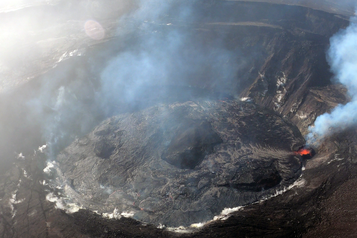
On the morning of October 8, 2021, HVO scientists completed a routine helicopter overflight of the ongoing eruption within Halema‘uma‘u at the summit of Kīlauea. This overview photo of the lava lake was captured from the northeast, with the erupting western fissure in the right of the frame, and a number of islands from the December 2020–May 2021 lava lake visible in the center.
Halemaʻumaʻu Lava Lake Observations:
Lava continues to erupt from a single vent in the western wall of Halemaʻumaʻu crater and lava fountains from the vent have sustained heights of about 15 meters (49 ft). The western end of the lake shows a maximum elevation of approximately 779 meters (2556 ft) above sea level as measured by field crews on October 8, which is a total increase of about 36 meters (118 ft) since lava emerged on September 29. The lava lake is above the base of the vent and the fountain has built a spatter rampart around it with an opening to the east. The fountain is feeding lava to the lake by a flow through the rampart opening. The previously active vent in the south part of the lake is no longer visible. The central island and several of the smaller eastern islets from the 2020 lava lake are still above the lake surface along with an island of the 2020 western vent rampart in the northwest part of the lake. The lava lake is not level across its surface due to the location of the vent in the western end. Areas closer to the vent are about 3 meters (10 ft) higher in elevation compared to the north and south part of the lake and 8 meters (26 ft) higher than the east end of the lava lake. Active lava and crustal foundering is now mainly focused on the western part of the lava lake.
Source : HVO.
Photo : USGS.
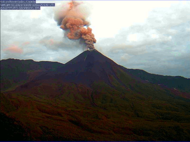
Ecuador , Reventador :
DAILY REPORT OF THE STATE OF THE REVENTADOR VOLCANO, Saturday 09 October 2021.
Information Geophysical Institute – EPN.
Surface activity level: High, Surface trend: No change.
Internal activity level: Moderate, Internal trend: No change.
Seismicity: From 08 October 2021, 11: 00h to 09 October 2021, 11: 00h:
The seismic statistics were carried out at the Cascales station, due to the persistent intermittence in the local network of the Reventador volcano.
Explosion (EXP) 78 events
Tremors d’Émission (TREMI) 5 events.
Rains / lahars: Light rains were recorded in the volcano area, which did not generate lahars.
Emission column / ash:
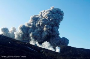
Gas and ash emissions were observed up to 1,200 meters above crater level in a westerly and north-westerly direction. The Washington VAAC reported ash emissions between 1338 and 1638 meters above the summit in a northwest and west direction.
Other monitoring parameters:
No thermal alerts have been recorded in the last 24 hours.
Observation:
The volcano area was largely cleared from last night until early morning today. At night and early in the morning, explosions, incandescences in the crater and rolling blocks were observed up to 500 meters below the summit on all sides of the volcano. Right now it’s cloudy
Alert level: Orange.
Source et photo : IG-EPN.
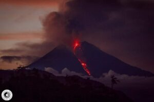
Mexico , Popocatepetl :
October 09, 11:00 a.m. (October 09, 4:00 p.m. GMT)
During the last 24 hours, according to the monitoring systems of the Popocatepetl volcano, 54 exhalations accompanied by water vapor and volcanic gases have been identified. In addition, 14 minutes of tremors were recorded.
For most of the time period covered by this report, there was no visibility towards the volcano, due to cloudy conditions. However, during the early hours of the morning, it was observed that volcanic gas emissions were scarce and scattered towards the west. For the moment there is no visibility.
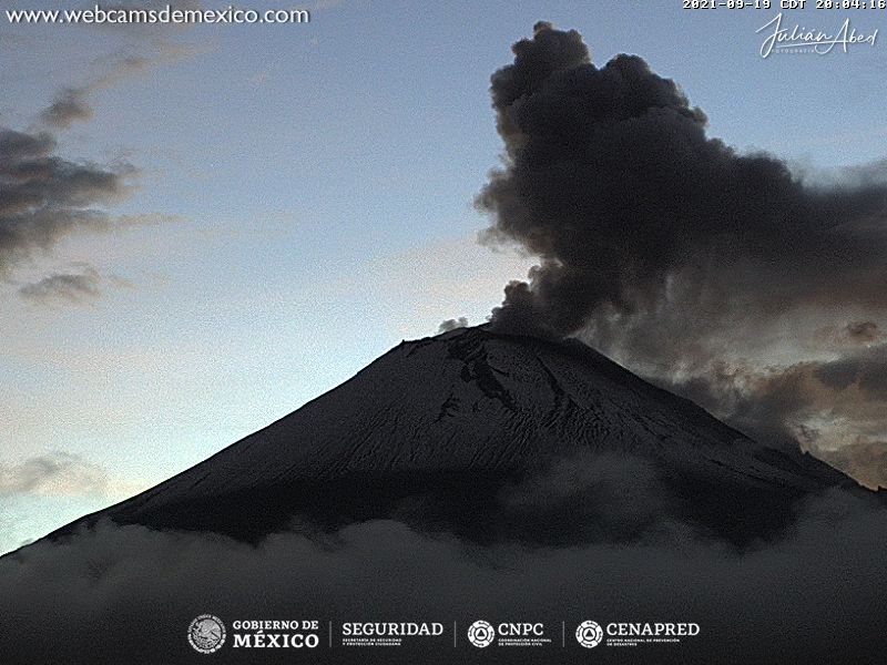
CENAPRED recommends NOT TO APPROACH the volcano and especially the crater, because of the danger of falling ballistic fragments and, in the event of heavy rains, to stay away from the bottom of the ravines because of the danger of mudslides and debris.
The Popocatépetl volcanic traffic light is in PHASE 2 YELLOW.
Source : Cenapred.
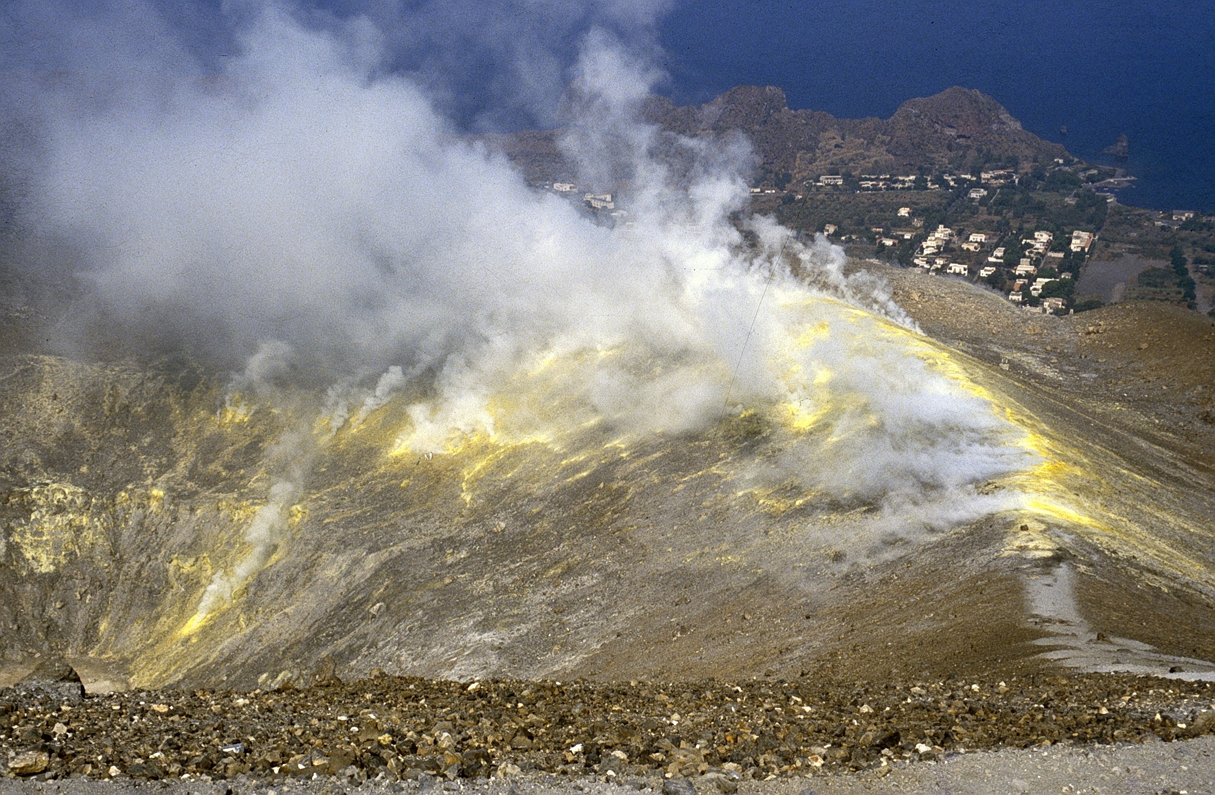
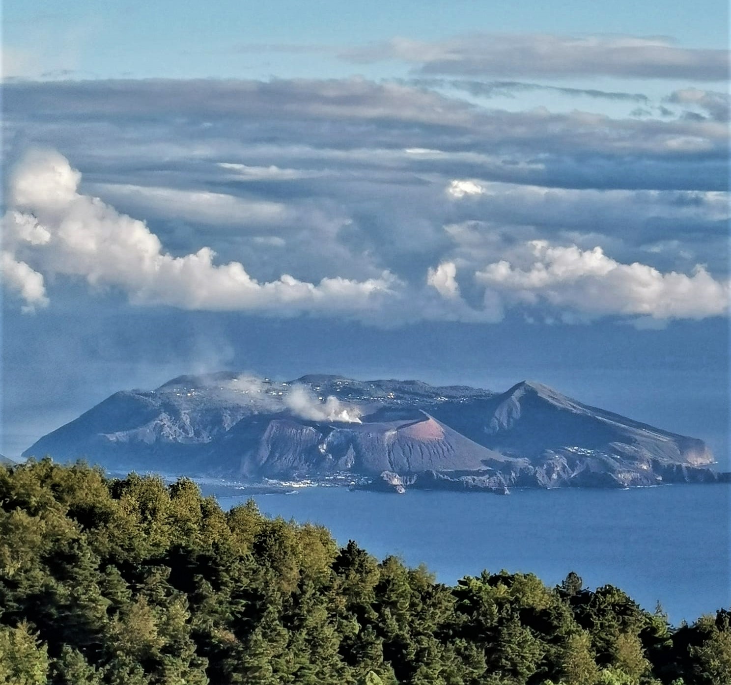
Italy , Vulcano :
Vulcano is an active volcanic system located at the southern end of the Salina-Lipari-Vulcano alignment in the Aeolian Islands archipelago. For around 5500 years and to this day, the active volcanic center is represented by the tuff cone of La Fossa which overlooks the city of Porto di Levante. Its last eruption took place between August 1888 and March 22, 1890. Until about 400 years ago, the small eruptive center of Vulcanello was also fully active.

The Fossa and the Vulcanello originate within a caldera of volcano-tectonic origin which formed in several phases and which takes its name from the main cone (Figure 1). La Fossa has had intense eruptive activity in historical times (last 2000 years), often at the same time as Vulcanello and, considering only the last 500 years, there are two cycles of prolonged eruptions (1727-1739; 1888 -1890), among which there were some very brief eruptive events reported in historical chronicles (1771, 1786, 1823-24, 1873, 1876, 1878-79, 1886), such as explosions and emissions of ash and « big boulders of fire » or, above all, frightening roars.
Activity after 1888-1890 and recent episodes of the troubles of the Fossa di Vulcano
For at least twenty years after the eruption of 1888-1990, the activity of fumaroles and the emission of gases suffered a decline and a sharp decline. But the state of the volcano has changed again, and since the beginning of the last century there have been a few episodes of unrest (term used in international parlance to describe a state of « unrest » of a volcano).
In 1916, it was Prof. Ottorino De Fiore who noticed a marked revival of fumarolic activity in the N-NW sector of La Fossa, measuring high temperatures at two different points: 352 ° C straddling the northern edge of the crater (from a new radial fracture, with NS tendency) and 416 ° C (from another fracture on the inner wall of the crater, below the first, with EW tendency).

Daily frequency and cumulative number of micro-tremors recorded at the IVCR station over the period 01/03/2021 – 30/09/2021
A new phase of heating of the fumaroles of the crater began at the end of 1977 and underwent a series of fluctuations, associated with significant variations in the contribution of « magmatic gases », that is to say those directly produced by the degassing of the magma (CO2 , SO2, H2S). In February 1980 a relatively high temperature (315 ° C) was measured, but during this year and until January 1984 geochemists observed decreasing temperature values and only slight changes in the chemical composition of the fluids emitted.
The temperature of the fumaroles on the edge of the crater increases several times to reach 650 ° C in 1991 and 690 ° C in June 1993. An increase in the exhalation surface is observed (from 50 m2 in 1983 to 650 m2 in 1990), accompanied by an increase in the emission rate. On January 28, 1991, a long-lasting seismic event was recorded (Magnitude 2.6). During the following years, the temperature of the gases gradually decreased, but the exhalation activity continued to experience periods of greater intensity and surface extension in 2004-2005 and in 2009.
The current situation and the evolutions of the current system
From July 2021, and in particular at the beginning of September, INGV’s monitoring systems have revealed the variation of certain geophysical and geochemical signals, in particular those linked to the activity of the hydrothermal system which feeds the fumaroles of the crater of the Fossa and the degassing area of the Grotte dei Palizzi, located at the southern base of the cone. In particular, an increase in the temperature of these fumaroles and a variation in the composition of the gases were observed, with a greater contribution from the components directly linked to magmatic degassing (CO2 and SO2). The increase in the isotopic ratio of Helium (a typical magmatic indicator), recorded by the INGV section of Palermo is consistent with this variation.
The temperature of the fumarolic gases increased to maximum values of 340 ° C, with points on the inner face of the crater where growth exceeded 100 ° C. Diffuse outgassing along the southern edge of the crater has also increased.

Automatic recording of temperature changes (° C) in the fumaroles on the edge of the northern slope of the La Fossa cone (extract from the Geochemical Monitoring Bulletin of the Island of Vulcano, August 2021).
The characteristics of these gases suggest an origin from the degassing of a magma of latite composition which would exist at depths between 3.5 and 4 km (other episodes of disturbances that occurred in 2004 and 2009 seem to be associated with bodies slightly more superficial magmatic).
From a seismic point of view, from September 13 a significant increase in micro-seismicity was observed in the area of the crater of La Fossa. This low-energy seismicity, generally located in the first kilometer of depth under the cone, is linked both to duct resonance phenomena and to fracturing processes in a hydrothermal environment, where weathered rocks have poor mechanical properties.
The current phase of increase was also characterized by the presence of seismic events (called VLP, Very Long Period) with a frequency content lower than that observed for the micro-shocks typically recorded on the Fossa. These seismic signals have never been recorded over the past 15 years, and their presence is compatible with an increase in fluids which induces duct pressurization and consequent resonance phenomena.
With regard to soil deformations, from mid-August GPS measurements showed a modest expansion of the area of the Fossa cone. This process accelerated in mid-September, and is still ongoing, with maximum displacements of up to 1 cm (northward, on the north side of the cone). This deformation of the ground would also seem to be confirmed by the INSAR measurements carried out by the CNR-IREA, which would indicate a vertical displacement of about 1 cm.
Source : INGV.
Photos : INGV , Boris Behncke, Viaggi e Vulcani.