July 20 , 2021 .
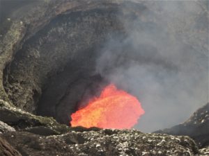
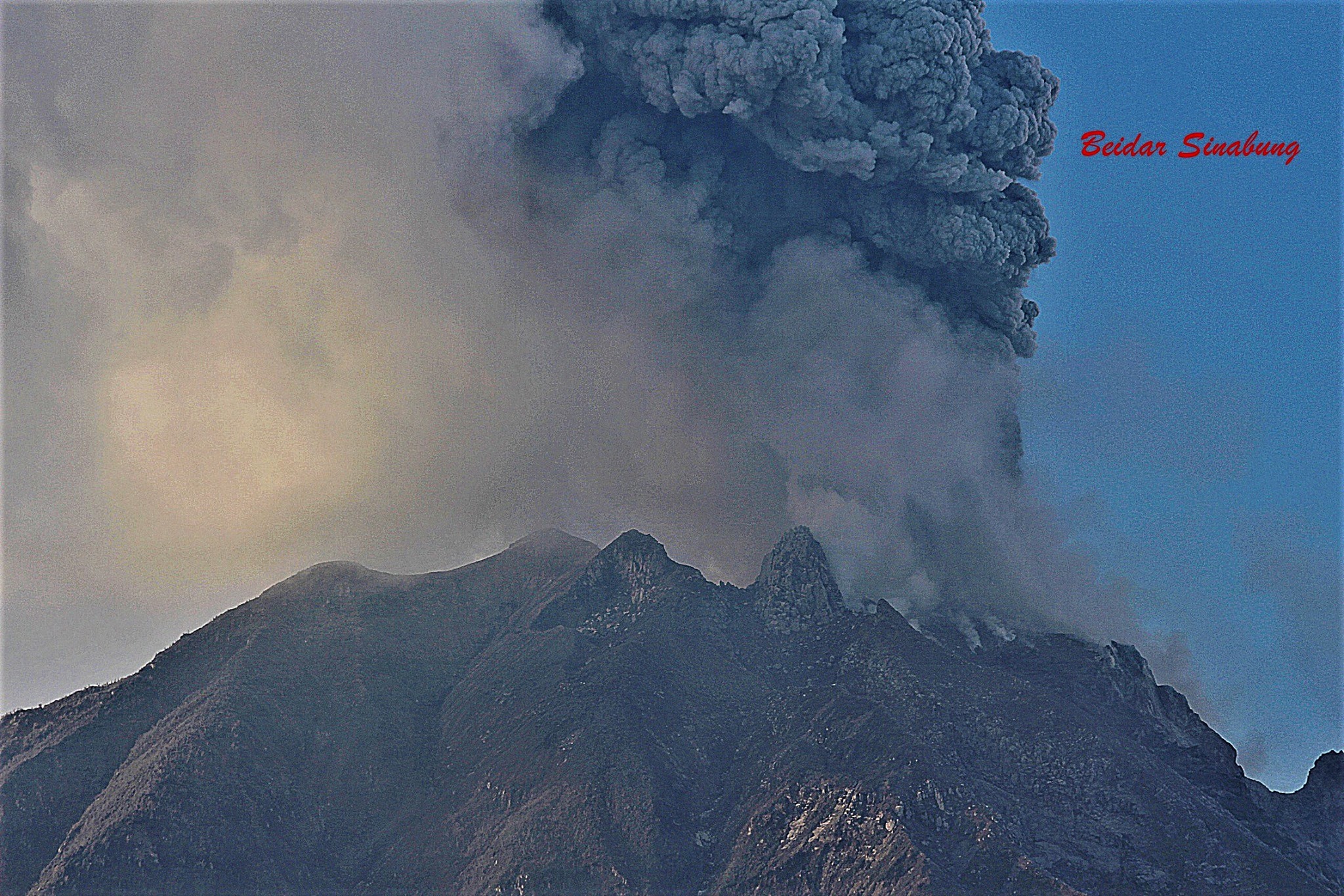
Indonesia , Sinabung :
VOLCANO OBSERVATORY NOTICE FOR AVIATION – VONA.
Issued : July 19 , 2021
Volcano : Sinabung (261080)
Current Aviation Colour Code : ORANGE
Previous Aviation Colour Code : orange
Source : Sinabung Volcano Observatory
Notice Number : 2021SIN78
Volcano Location : N 03 deg 10 min 12 sec E 98 deg 23 min 31 sec
Area : North Sumatra, Indonesia
Summit Elevation : 7872 FT (2460 M)
Volcanic Activity Summary :
Eruption with ash clouds at 02:25 UTC (18:50 local time). The eruption lasted for 662 seconds.
Volcanic Cloud Height :
Best estimate of ash-cloud top is around 11072 FT (3460 M) above sea level, may be higher than what can be observed clearly. Source of height data: ground observer.
Other Volcanic Cloud Information :
Ash-cloud moving to E-SE.
Remarks :
Deep seismic activity is characterized by volcanic earthquake, Low Frequency Earthquake, and Hybrid Earthquake.
Level of activity at level III (SIAGA) since May 20, 2019 at 10:00 a.m. WIB. The Sinabung volcano (2,460 m above sea level) has been erupting since 2013.
The volcano is clearly visible until it is covered in fog. White smoke from the main crater was observed with high intensity about 50 meters above the summit. The weather is sunny to cloudy, the wind is weak to strong in the North-East, East and South-East.
According to the seismographs of July 18, 2021, it was recorded:
1 emission earthquake
3 hybrid / multi-phase earthquakes
2 local tectonic earthquakes
Sources : Magma Indonésie , PVMBG.
Photo : beidar sinabung 18 avril 2021
Italy / Sicily , Etna :
Press release on ETNA activity, July 20, 2021, 00:36 (22:36 UTC).
The National Institute of Geophysics and Volcanology, Osservatorio Etneo, announces that from approximately 22:00 UTC the resumption of Strombolian activity is observed at the level of the Southeast Crater. According to the forecast model, the volcanic ash produced by the current activity is dispersed in a southerly direction.
The temporal trend of the mean amplitude of the seismic signal which from the afternoon of the 18th has been characterized by large fluctuations, and currently shows a fairly stationary trend on medium-high values. The location of the centroid of the volcanic tremor sources is currently located in correspondence with the Southeast Crater at an altitude of about 2700 m above sea level.
The infrasound activity shows a recovery around 21:30 UTC and currently an average level activity is observed mainly localized in the Southeast Crater.
Signals from permanent GNSS networks and inclinometric distortion monitoring do not show any significant change.
Press release on ETNA activity, July 20, 2021, 05:37 (03:37 UTC).
The National Institute of Geophysics and Volcanology, Osservatorio Etneo, reports that an increase in Strombolian activity is observed at the level of the Southeast Crater. According to the forecast model, the eruptive cloud produced by the current activity disperses towards the South-South-East. From around 02:20 UTC there is a sudden increase in the amplitude of the volcanic tremor which has reached high values. The centroid of the tremor sources is located in correspondence with the Southeast Crater at an altitude of about 2900 m above sea level.
Also from around 02:20 UTC, an increase in infrasound activity is observed which has reached high levels and is located in correspondence with the Southeast Crater. Signals from permanent GNSS networks and inclinometric distortion monitoring do not show significant variations
Further updates will be communicated shortly.
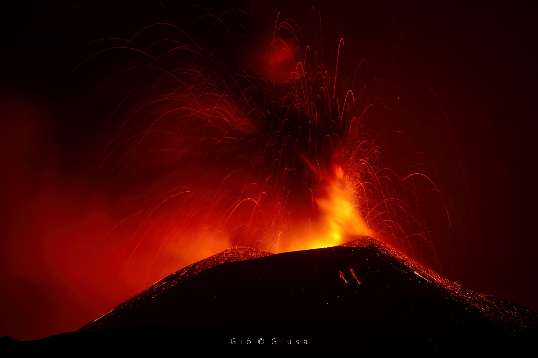
07:47 (05:47 UTC):
We observe the gradual passage of Strombolian activity to the lava fountain stage at the Southeast Crater. Based on the forecast model, the eruptive cloud produced by the current activity disperses towards the South-South-East. In addition, an overflow is observed on the lava surveillance cameras advancing towards the southwest.
The average amplitude of the volcanic tremor, compared to the previous press release, has further increased and currently displays very high values.
The center of gravity of the sources of volcanic tremor is located near the Southeast Crater at an altitude of about 2900 to 3000 m above sea level.
The infrasound activity also shows a marked increase in both the frequency of occurrence and the amplitude of events and is located near the Southeast Crater.
Source : INGV
Vidéo : Guide Alpine Vulcanologiche Etna.
Photo : Gio Giusa
Peru , Sabancaya :
Analysis period: July 12, 2021 to July 18, 2021, Arequipa, July 19, 2021.
Alert level: ORANGE
The Geophysical Institute of Peru (IGP) reports that the eruptive activity of the Sabancaya volcano remains at moderate levels, that is to say with the recording of an average of 100 daily explosions, with columns of ash and gas up to an altitude of 2.0 km above the summit of the volcano and their consequent dispersion. Therefore, for the following days, no significant change is expected in eruptive activity.
The IGP recorded and analyzed the occurrence of 1,124 earthquakes of volcanic origin, associated with the circulation of magmatic fluids within the Sabancaya volcano. An average of 100 explosions was recorded daily. During this period, Volcano-Tectonic (VT) earthquakes associated with rock fracturing were located mainly in the North, North-East and North-West of Sabancaya and presented magnitudes between M1 , 8 and M3.1.
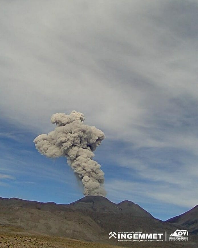
The monitoring of the deformation of the volcanic structure using GNSS techniques (processed with fast orbits) does not present any significant anomalies. However, in general, an inflation process was observed in the northern sector (around the Hualca Hualca volcano). Visual surveillance identified columns of gas and ash up to an altitude of 2.0 km above the summit of the volcano, which were scattered towards the South, South-East, East and North-East sectors of the volcano. Sabancaya. Satellite recordings have identified the presence of 11 thermal anomalies (maximum value of 48 MW) associated with the presence of a lava body on the surface of the volcano’s crater.
RECOMMENDATIONS
• Keep the volcanic alert level in orange.
• Do not approach within a radius of 12 km from the crater.
Source : IGP.
Photo : Ingemmet
Philippines , Taal :
TAAL VOLCANO BULLETIN: 20 July 2021 8:00 AM
In the past 24-hour period, the Taal Volcano Network recorded thirty-six (36) volcanic earthquakes, including thirteen (13) volcanic tremor events having durations of one (1) to ten (10) minutes, twenty (20) low-frequency volcanic earthquake, three (3) hybrid events and low-level background tremor that has persisted since 07 July 2021. Two of the tremor events occurred at 10:18 AM and 10:38 AM were felt at Intensity I in Pira-piraso, Taal Volcano Island, the earlier event reportedly accompanied by a rumbling sound. High levels of volcanic sulfur dioxide or SO2 gas emissions and steam-rich plumes that rose one thousand two hundred (1200) meters before drifting east and northeast were generated from the Taal Main Crater. Sulfur dioxide (SO2) emission averaged 3,780 tonnes/day on 19 July 2021. Based on ground deformation parameters from electronic tilt, continuous GPS and InSAR monitoring, Taal Volcano Island has begun deflating in April 2021 while the Taal region continues to undergo very slow extension since 2020.
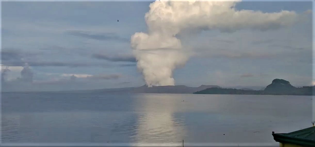
Alert Level 3 (Magmatic Unrest) now prevails over Taal Volcano. At Alert Level 3, magma extruding from the Main Crater could drive explosive eruption. The public is reminded that the entire Taal Volcano Island is a Permanent Danger Zone (PDZ), and entry into the island as well as into the high-risk barangays of Agoncillo and Laurel must be prohibited due to the hazards of pyroclastic density currents and volcanic tsunami should strong eruptions occur. All activities on Taal Lake should not be allowed at this time. Communities around the Taal Lake shores are advised to remain vigilant, take precautionary measures against possible airborne ash and vog and calmly prepare for possible evacuation should unrest intensify. Civil aviation authorities must advise pilots to avoid flying over Taal Volcano Island as airborne ash and ballistic fragments from sudden explosions and pyroclastic density currents such as base surges may pose hazards to aircraft.
DOST-PHIVOLCS maintains its close monitoring of Taal Volcano and any new development will be communicated to all concerned stakeholders.
Source : Phivolcs.
Photo : Stefan Wagner
Hawaii , Mauna Loa :
19°28’30 » N 155°36’29 » W,
Summit Elevation 13681 ft (4170 m)
Current Volcano Alert Level: ADVISORY
Current Aviation Color Code: YELLOW
Activity Summary:
Mauna Loa Volcano is not erupting. Rates of seismicity at the summit remain slightly elevated and above long-term background levels. Other Mauna Loa monitoring data streams show no significant changes that would indicate increased volcanic hazard at this time.

Observations:
During the past week, HVO seismometers recorded approximately 42 small-magnitude (below M2.5) earthquakes beneath the summit and upper-elevation flanks of Mauna Loa, and 106 beneath the volcano’s southeast flank. The majority of these earthquakes occurred at shallow depths less than 8 kilometers (5 miles) below sea level.
Global Positioning System (GPS) measurements show low rates of deformation in the summit region continuing through the past week.
Gas concentrations (0 ppm SO2; up to 4 ppm H2S) and fumarole temperatures (below 100°C/212°F) at both the summit and at Sulphur Cone on the Southwest Rift Zone remain stable.
Webcam views have shown no changes to the volcanic landscape on Mauna Loa over the past week.
Source et photo : HVO