January 31 , 2021.
Indonesia , Merapi :
Mount Merapi activity report from January 22 to 28, 2021
I. OBSERVATION RESULTS
Visual
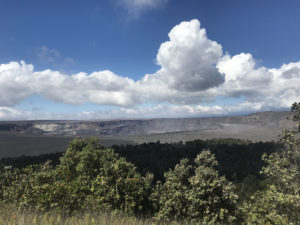
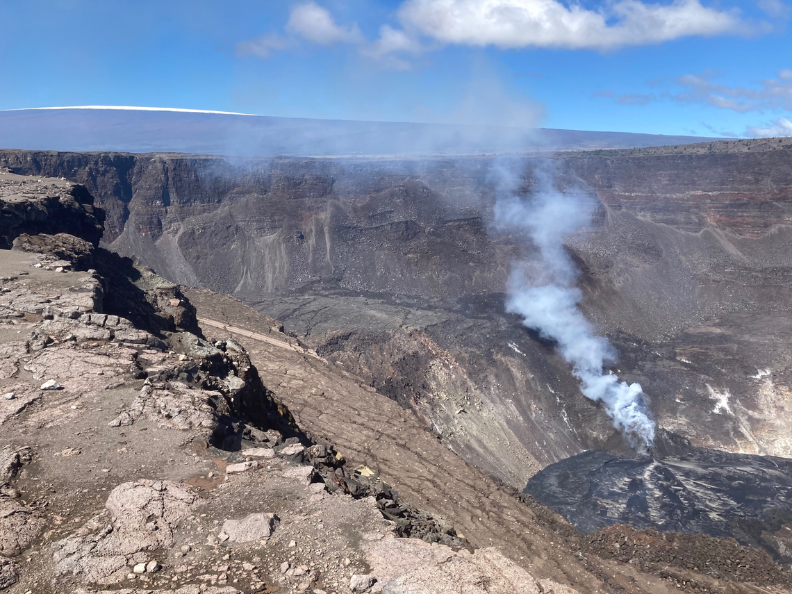
The weather around Mount Merapi is generally sunny in the morning, while the afternoon until evening is foggy. There is white smoke, thin to thick with low pressure. A maximum smoke height of 750m was observed from the Mount Merapi observation post in Kaliurang on January 25, 2021 at 5:30 a.m. WIB.
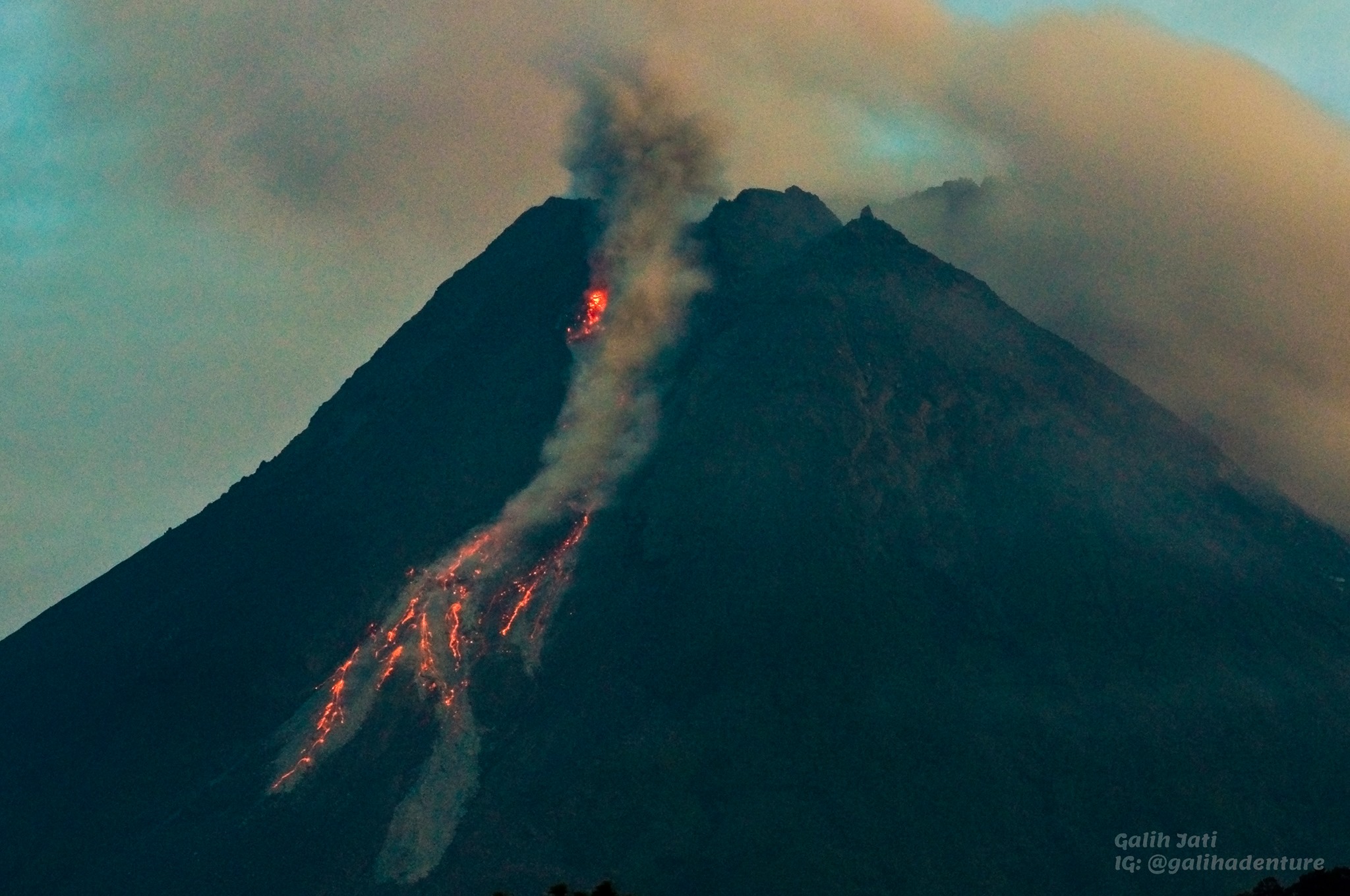
During this week, avalanches of incandescent lava were observed 230 times with a maximum slide distance of 1,500 meters southwest to the upper reaches of the Kali Krasak and the Kali Boyong. Hot avalanche clouds occurred 71 times with a maximum slide distance of 3500 meters towards the Kali Boyong and were recorded on a seismogram with a maximum amplitude of 70 mm and a duration of 240 seconds.
Morphological analysis of the summit area based on photos of the southwest sector from January 21 to January 26, 2021 shows a change in the morphology of the peak area due to avalanche activity and the development of new lava domes . As of January 25, 2021, the measured volume of the 2021 lava dome is 157,000 m3. Then on January 28, 2021, it was reduced to 62,000 m3 mainly due to the activity of avalanches and hot clouds that occurred on January 26 and 27, 2021.
Seismicity
This week, the seismicity of Mount Merapi recorded:
71 hot cloud avalanches (AP),
6 shallow volcanic earthquakes (VTB),
105 multi-phase earthquakes (MP),
1148 avalanche earthquakes (RF),
122 emission earthquakes (DG)
1 tectonic earthquake (TT).
In general, internal seismicity this week was lower than last week, while surface earthquakes such as avalanche earthquakes and hot clouds increased.
Deformation
The deformation of Mount Merapi which was monitored using EDM this week showed a shortening rate of 0.4cm / day, which decreased from the previous week.
Rain and lahars
This week, there was rain at Mount Merapi Observation Post with the highest rainfall intensity of 240mm / hour for 135 minutes at Kaliurang Post on January 27, 2021. On January 25, 2021 at 4.30pm WIB, it It was reported that there was an increase in flow in the Boyong, Gendol and Woro rivers.
Conclusion
Based on the results of visual and instrumental observations, it is concluded that:
The volcanic activity of Mount Merapi is still quite high in the form of effusive eruption activity. The status of the activity is defined at the “SIAGA” level.
The current potential dangers are in the form of lava avalanches and hot clouds in the South-South-West sector covering the Boyong, Bedog, Krasak, Bebeng and Putih rivers with a maximum distance of 5 km. During this time, the ejection of volcanic material in the event of an explosive eruption can reach a radius of 3 km around the summit.
Source : BPPTKG
Photo : Yohannes Tyas Galih Jati
Hawaii , Kilauea :
19°25’16 » N 155°17’13 » W,
Summit Elevation 4091 ft (1247 m)
Current Volcano Alert Level: WATCH
Current Aviation Color Code: ORANGE
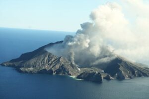
The eruption at Kīlauea summit continues with the west vent supplying lava to the active western lava lake in Halema‘uma‘u (visible in the lower right corner). Gas emission rates remain elevated and were measured at about 2,200 t/d on January 23. Just left of center is a remnant of Crater Rim Drive, on a block that dropped during the 2018 summit collapses. Snow from a recent storm can be seen on the summit of Mauna Loa Volcano, in the upper left corner of the image. This photo was taken in an area of Hawai‘i Volcanoes National Park that remains closed to the public for safety reasons.
Activity Summary:
Kīlauea Volcano is erupting. Lava activity is confined to Halemaʻumaʻu with lava erupting from a vent on the northwest side of the crater. As of the morning of January 30 lava has filled about 211 m (692 ft) of Halemaʻumaʻu and only the western portion of the lava lake is active. SO2 emission rates remain elevated.
Summit Observations:
The most recent sulfur dioxide emission rate measurements from January 23, are about 2,200 t/d—lower than the emission rates from the pre-2018 lava lake (3,000–6,500 t/d). The summit tiltmeters are on an inflationary trend. Seismicity remains elevated but stable, with steady elevated tremor and a few minor earthquakes.
Halemaʻumaʻu lava lake Observations:
Lava from the west vent continues to supply Halema‘uma‘u crater with lava. Recently, effusion rates have correlated positively with inflationary tilt at Kīlauea’s summit.
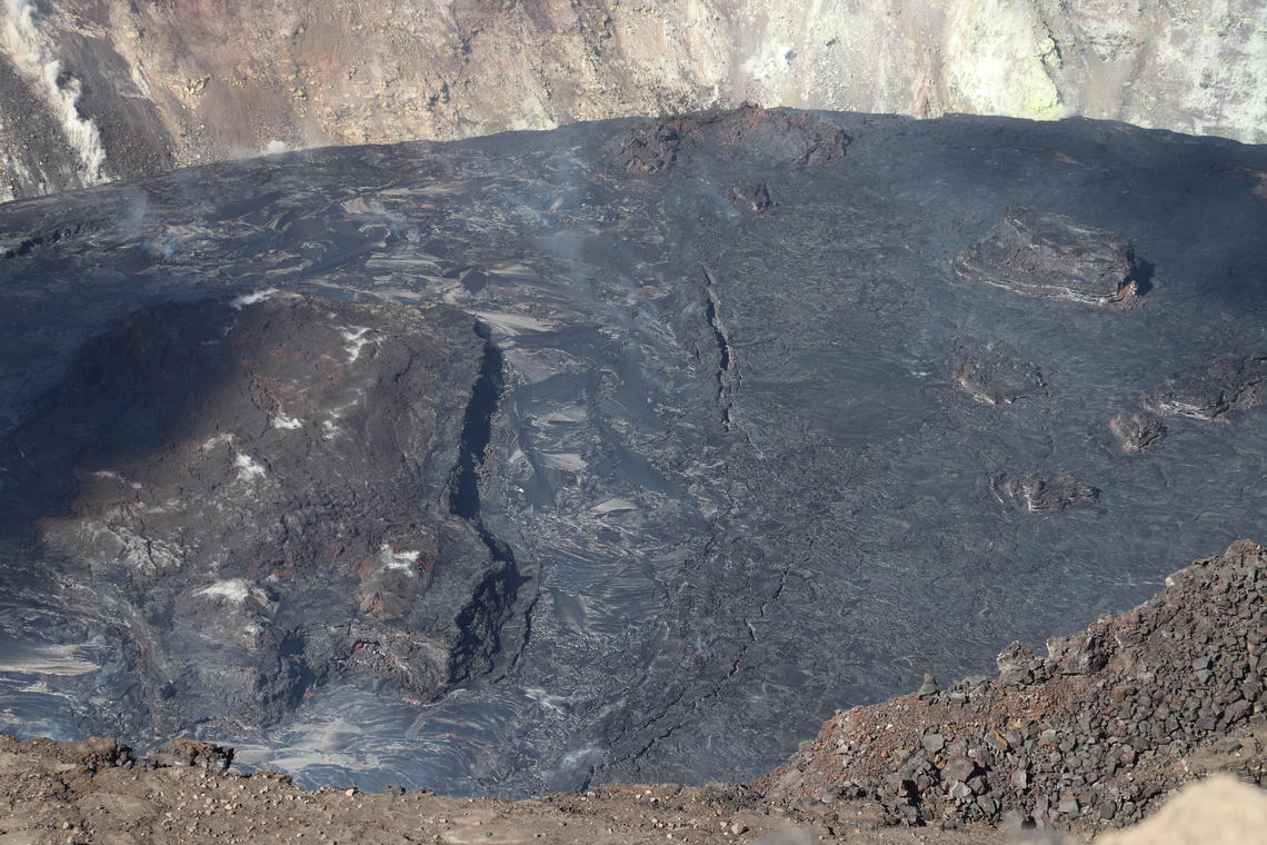
A north-south trending line of surficial cracks divides the boundary between the western active portion (left) and eastern stagnant portion (right) of the Halema‘uma‘u lava lake. Lake depth measurements taken on January 28th on both sides of the cracks (near center) indicate that the eastern portion of the lava lake is 4 meters (13 ft) lower than the western portion of the lava lake. In this view looking north, the majority of the largest island is visible in the western portion of the lava lake (gray shiny surface). In contrast, the stagnant eastern portion is a duller gray with several smaller islands visible. North of the cracks (upper center), the top of the inactive northern vent spatter cone is nearly submerged by the rising lava lake.
As of the morning of January 30 lava has filled about 211 m (692 ft) of Halemaʻumaʻu in the active western portion of the lava lake. The western vent has crusted over except for a single (possibly two) skylights that are mostly obscured by volcanic gas. The west end of the lava lake is still active with lava flows occasionally breaking out and covering portions of the lava lake. The stagnant eastern area of the lake remains about 5 m (15 feet) lower than the perched, elevated, and active western portion. A series of surface cracks separates the active from the stagnant part of the lake.
Source : HVO
Photos : USGS/ M. Patrick , USGS/N. Deligne .
Saint Vincent , Soufrière Saint Vincent :
LA SOUFRIÈRE BULLETIN ,JANUARY 30, 2021 , 12:00 PM
Three (3) GPS stations are currently streaming data to Seismic Research Centre. Telemetry of the data being collected from the new GPS station installed at the Richmond Vale Academy on 23 January, is still ongoing. Since 31 December 2020, no significant deformation signals related to the current effusive eruption have been observed.
Electronic Distance Measurement (EDM) reflectors were installed at the summit on 25 January to assist with measurements of deformation associated with the flanks of the volcano. On 29 January, 12 locations were identified as potential sites for obtaining readings from the summit reflectors. Additional reflectors will be installed at the summit on the trip planned for 2 February, in an attempt to maximize chances to hit the reflectors from multiple acquisition locations.
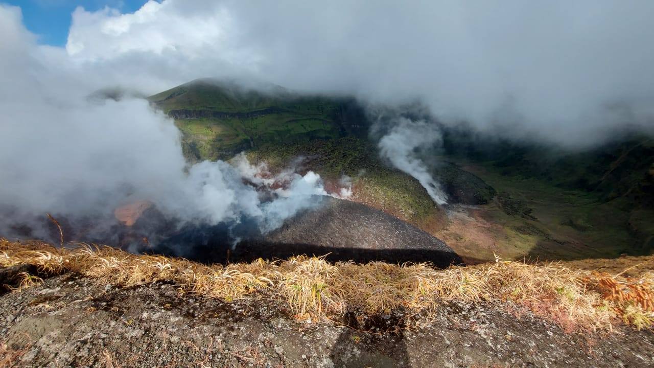
Why do the domes (new and old) steam? They steam because there is a large amount of hot rock present and when it combines with the high volume of ground water in the crater, the heat causes the water to boil – think a boiling kettle. There is also volcanic gases mainly CO2 and some sulphides (these give off the unpleasant smells). The steaming is most prominent at the top of the new dome and at the interface between the old dome and the new because there is now more gaps through which the steam can come through. The fumarolic activty along the old dome will also steam more due to the increased activity within the crater.
Since the installation of station on 06 January on the flanks of the volcano, at Wallibou, and the one at the summit, on 18 January, 573 events have been recorded, up to 07:30 a.m., on 30 January.
The National Emergency Management Organisation is reminding the public that no evacuation order or notice has been issued.
Source et photo : NEMO
Mexico , Popocatepetl :
January 30, 11:00 a.m. (January 30, 5:00 p.m. GMT)
During the last 24 hours, through the monitoring systems of the Popocatépetl volcano, 36 exhalations and 501 minutes of tremor have been identified, accompanied by emissions of water vapor, volcanic gases and ash.
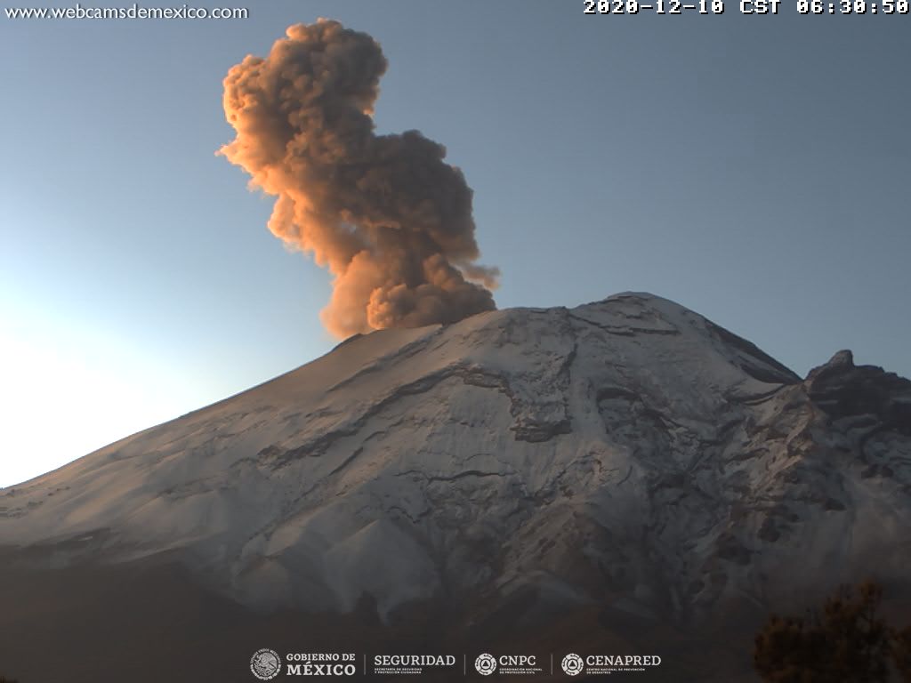
In the early morning and at the time of this report, intermittent emissions of volcanic gases are observed dispersed towards the northwest.
CENAPRED urges NOT TO APPROACH the volcano and in particular the crater, because of the danger posed by the fall of ballistic fragments and, in the event of heavy rains, to stay away from the bottom of the ravines because of the danger of flows mud.
The Popocatépetl volcanic alert semaphore is in YELLOW PHASE 2.
Source : Cenapred
Photo : Archive cenapred.