July 24 , 2020.
Iceland , Reykjanes Peninsula :
Update on the activity in the Reykjanes peninsula. July 23 , 2020.
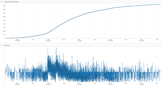
Since the intense seismic swarm started in Fagradalsfjall on the 18th of July, the activity has been slowly decreasing over time. The acquisition of recent satellite images enabled mapping of new surface deformation in the area associated with the sequence of large earthquakes which occurred between the 18th and 20th of July. The satellite data processing clearly shows a deformation signal corresponding to approximately 3 centimeters of movement along a NE-SW oriented fault in the region of Fagradalsfjall (See black box in the figure above). This fault was identified during the 2017 earthquake swarm which also occurred in this area. The current earthquake activity is interpreted to be part of a larger scale volcano-tectonic reactivation event in the Reykjanes peninsula.
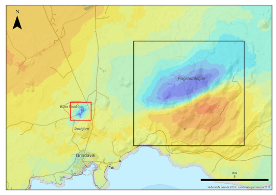
Interferometric synthetic aperture radar (InSAR) image obtained using Sentinel satellite data, covering the period 16-22 July 2020.
A small subsidence signal in the Svartsengi area
The satellite images also reveal a small subsidence signal in the Svartsengi area (See picture above – red box). The observed subsidence commenced between the 16th-18th July (slightly before the occurrence of the large tectonic earthquakes in Fagradalsfjall) and the next satellite image (expected for the end of this week) will confirm if the deflation is still ongoing or if this has stopped. Deformation modelling will be undertaken to verify the origin of this signal.
No significant changes are reported regarding the geochemical measurements performed this week on the peninsula. In addition the geothermal power plant in Svartsengi reports no changes in their routine measurements.
Seismicity in the Reykjanes peninsula since the 18th of July.
The ongoing activity on the Reykjanes peninsula, which commenced at the end of 2019, reflects a widespread volcano-tectonic reactivation of a large section of the peninsula, currently spanning Eldey in the west to Krýsuvík in the east. Activity (including additional earthquakes and magmatic intrusions) is likely to continue, with the focus switching between different areas along the peninsula.

Possible hazards:
Landslides and falling rocks might be triggered by earthquakes, most likely in regions with unstable slopes, steep cliffs and loose material
Earthquakes up to M5.5-6 might occur in areas along the Reykjanes peninsula with the potential to effect the captial region
Gas accumulation in depressions might occur in the event of very still wind conditions
Source : Vedur is.
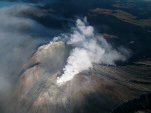
Photo : Fagradalsfjall / Volcanodiscovery.
Alaska , Veniaminof :
56°11’52 » N 159°23’35 » W,
Summit Elevation 8225 ft (2507 m)
Current Volcano Alert Level: ADVISORY
Current Aviation Color Code: YELLOW
Low-level seismic unrest continues at Veniaminof. Local seismicity continues to be partially obscured by the aftershocks following the magnitude 7.8 tectonic earthquake that occurred July 21 at 10:12 PM AKDT (July 22, 06:12 UTC). No explosive activity was detected by regional infrasound sensors. No activity was observed in cloudy satellite and web camera imagery.
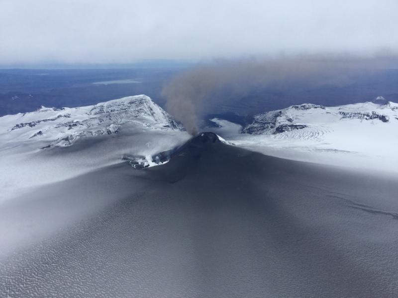
Photo of Veniaminof’s eruptive plume and ash on the caldera glacier taken by Mark Laker (USFWS) on 26 September 2018.
Veniaminof volcano is monitored with a local real-time seismic network, which will typically allows AVO to detect changes in unrest that may lead to a more significant explosive eruption. AVO combines seismic, infrasound, lightning, and satellite data for rapid detection of such events.
Source : AVO.
Photo : Laker, Mark.
Hawaii , Mauna Loa :
19°28’30 » N 155°36’29 » W,
Summit Elevation 13681 ft (4170 m)
Current Volcano Alert Level: ADVISORY
Current Aviation Color Code: YELLOW
Activity Summary:
Mauna Loa Volcano is not erupting. Rates of deformation and seismicity have not changed significantly over the past week and remain above long-term background levels.
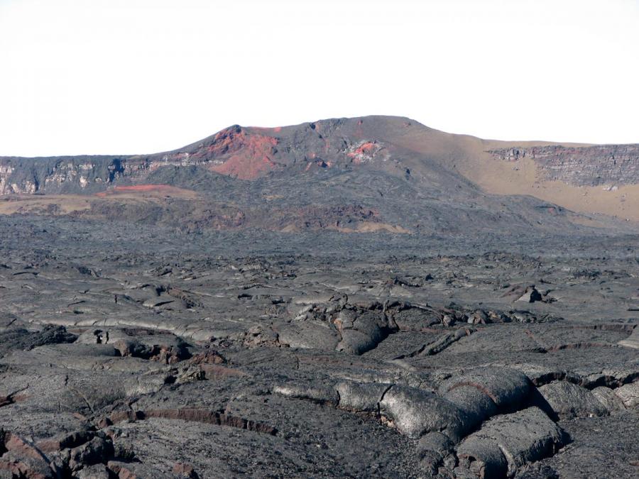
Spatter and cinder cone from 1949, in the Moku’aweoweo caldera atop Mauna Loa.
Observations:
During the past week, HVO seismometers recorded 97 small-magnitude earthquakes on the volcano’s summit and upper-elevation flanks. Most of these earthquakes occurred at shallow depths of less than 8 kilometers (~5 miles) below ground level.
Global Positioning System (GPS) measurements show continued slow summit inflation, consistent with magma supply to the volcano’s shallow storage system.
Gas concentrations at the Summit and Sulphur Cone monitoring sites remain stable (below 2 ppm SO2). Fumarole temperatures as measured at both Sulphur Cone and the summit are ~98 C and are in the normal range.
Webcams show no changes to the landscape.
.
Source : HVO.
Ecuador , Reventador :
Increase in volcanic activity.
Summary:
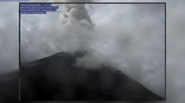
Over the past two weeks, a slight increase in surface eruptive activity has been observed on the El Reventador volcano located between the provinces of Napo and Sucumbíos. The activity is characterized by the generation of eruptive columns and pyroclastic density currents (CDP or pyroclastic flows) generated from the crater of the volcano, which are preferentially directed towards its western, northern and northeastern flanks of the volcanic building, in now its deposits inside the amphitheater. This was confirmed by the presence of thermal anomalies on the east flank detected by the infrared camera located on the northeast flank, while thanks to satellite thermal sensors (FIRMS, MIROVA) it is possible to detect activity on the western flank. The heights of the gas and ash emissions reach between 0.7 and 1.3 km above the level of the crater and extend for several kilometers to the northwest, west and southwest of the volcano.
Relative comparisons of seismic amplitudes between explosions with and without associated pyroclastic flows show that explosions with pyroclastic flows are more seismic and energetic, leading to a change in the level of surface activity.
Therefore, the activity of El Reventador volcano is currently classified as HIGH with an ascending trend; However, it is important to note that this variation does not exceed the levels observed on the volcano in recent months and years.
Surface activity:
The eruptive activity exhibited throughout these weeks was characterized by the generation of explosions and pyroclastic flows (CDP), which originate from the crater of the volcano (Figure 1-A) whose ash content varies from low to high and their dispersion was made towards the North-West, the West and the South-West. Associated with this explosive activity, the expulsion and the rolling of blocks on the sides of the volcano were observed (Figure 1-B). The current shape of the crater favors the distribution of these phenomena and their deposits mainly on the north and northeast flanks, even if on occasion, it has also been observed that the ejected material is distributed around all the sides of the volcano. (Figure 1-C).
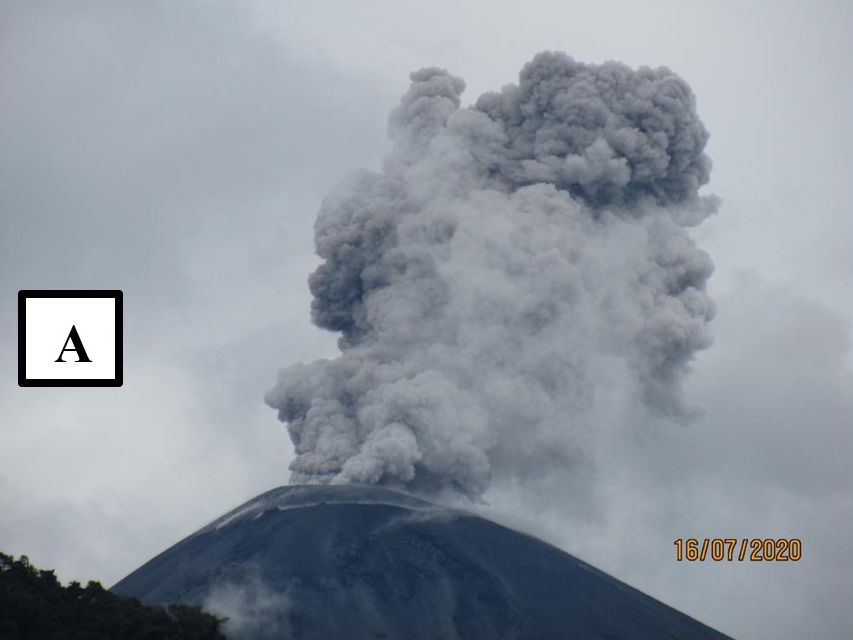


Figure 1. A) Explosion of the El Reventador volcano, an ash column about 0.5 km high, which the wind directs towards the North, which occurred on 07/16/2020 (Photo: Darwin Yánez, SNGRE technician); B) IR image where the occurrence of a pyroclastic flux (CDP) is recorded on 07/22/2020 at 02:46 (UTC), and C) IR image of the deposits generated after the occurrence of an explosion that has distributed pyroclastic material on the flanks of the volcano (05/07/2020 at 07:55 (UTC).
In addition, thermal anomalies were detected on the eastern flank recorded by the infrared camera located on the northeast flank, and thanks to remote sensors (FIRMS), thermal anomalies associated with the activity on the western flank can be observed (Figure 2).
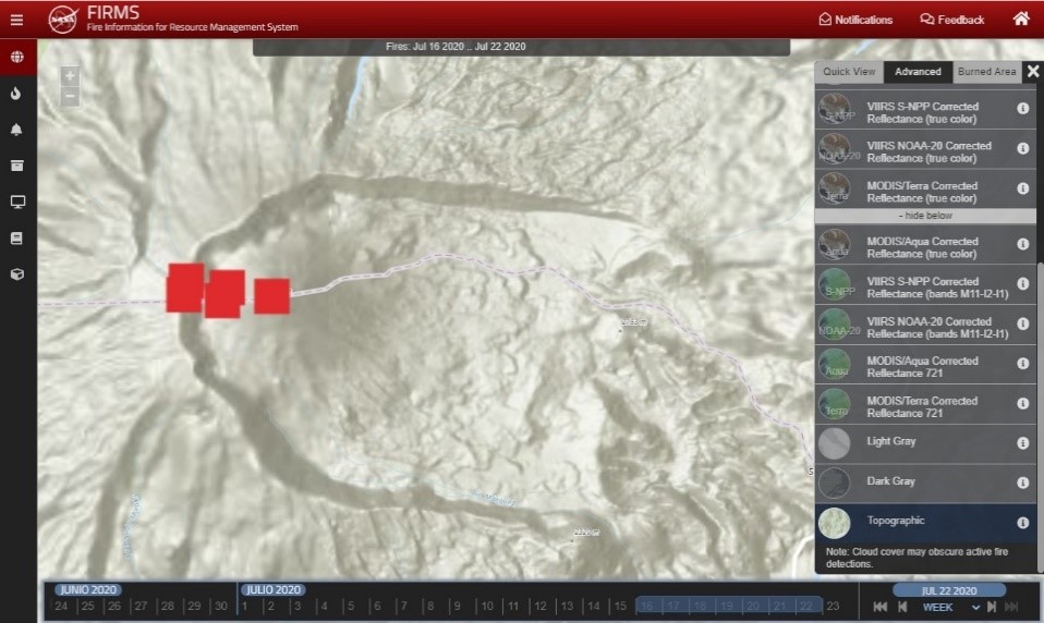
Figure 2. Thermal alerts detected by the FIRMS system on the El Reventador volcano during the previous week.
… / …
Most likely scenario: eruptive activity continues.
Whereas the eruptive activity continues to present phases of greater eruptive activity (like the one we are seeing right now) with phases of less activity (such as those observed in recent weeks). The main scenario proposed involves the recurrent generation of pyroclastic flows (CDP) whose deposits accumulate on the flanks of the volcano. In this scenario, the main phenomena likely to affect the population are: (1) ash falls associated with explosive activity and the remobilization of material raised by pyroclastic density currents. This ash, thus generated, is governed by the direction and speed of the wind, which at this time of year is typically strong and directed towards the west. Based on the data available to date, this scenario is most likely in the short term. Another phenomenon (2), less recurrent but probable is the mudslides (lahars) in the rivers (whose sources originate on the volcano), this associated with the occurrence of heavy rains, typical of this region and capable of transporting the material accumulated on the flanks of the volcano
. …/…
Source : IGEPN.
Read the full article : https://www.igepn.edu.ec/servicios/noticias/1823-informe-especial-del-volcan-el-reventador-n-1-2020.
Mexico , Popocatepetl :
July 23, 11:00 a.m. (July 23, 4:00 p.m. GMT)
During the last 24 hours, thanks to the monitoring system of the Popocatépetl volcano, nine exhalations have been identified, accompanied by volcanic gases and sometimes small amounts of ash, as well as a moderate explosion, recorded yesterday at 9:27 p.m.
In addition, 1348 minutes of tremor were recorded, including 854 minutes of low amplitude and 494 minutes of moderate amplitude, accompanied by emission of steam, gas and low ash content, with heights up to 2000 meters, in the southwest direction. The National Center for Communication and Civil Protection Operations (CENACOM) reported light ash fall in the following municipalities: Tetela del Volcán, Ocuituco, Atlatlahucán, Yecapixtla, Yautepec and Jiutepec, in the state of Morelos, as well as Juchitepec, Tepetlixpa, Atlautla, Ozumba and Ecatzingo, in the state of Mexico.
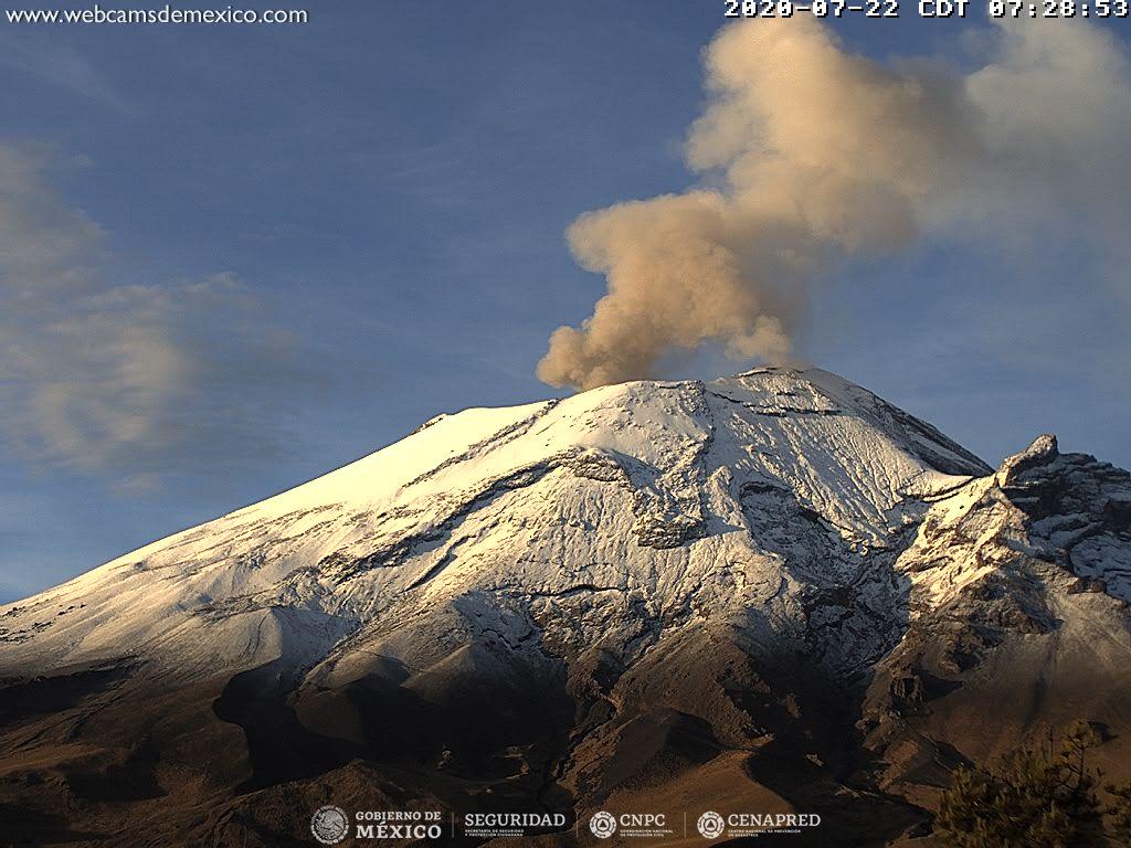
An incandescence was observed at night above the crater.
Since dawn and at the time of this report, there has been a constant emission of water vapor, gas and small amounts of ash dispersed towards the southwest.
CENAPRED urges NOT TO APPROACH the volcano and especially the crater, because of the danger involved by the fall of ballistic fragments and, in the event of heavy rains, to move away from the bottom of the ravines because of the danger of mudslides and debris.
The Popocatépetl volcanic alert signal light is in YELLOW PHASE 2.
Source : Cenapred.