April 11 , 2020.
Indonesia , Anak Krakatau :
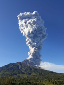
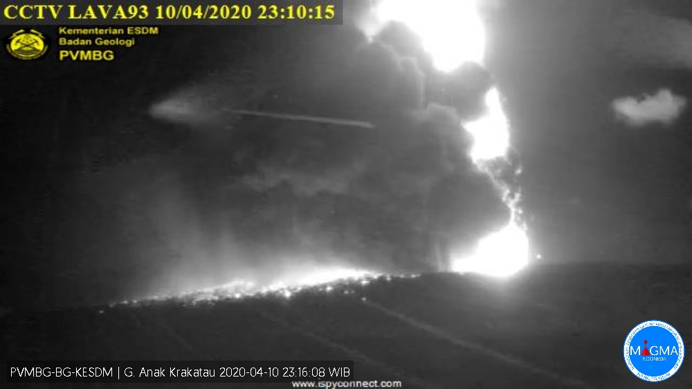
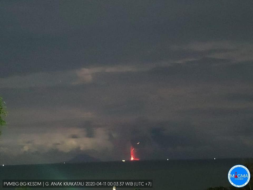
Press release on the volcanic activity of Anak Krakatau, April 11, 2020.
After the alert level of G. Anak Krakatau dropped from level III to Waspada level (level II) on March 25, 2019, the volcanic activity of Anak Krakatau fluctuated. From January to March 2020, eruptions continued almost continuously.
Monitoring data:
Visual observation: in January 2020, there were four eruptions on 1.7 and 15 January producing columns of gray / white eruptions with a maximum height of 500 m above the summit. From February 6 to 11, 2020, a series of eruptions occurred, resulting in thick white-gray eruption columns with a maximum height of 1000 m. In March 2020, there were two eruptions on March 18, 2020, resulting in an eruption of white and gray columns rising 300 m above the summit. When no eruption occurs, a fine white smoke of a maximum height of 150 m from the top is observed. On April 10, 2020, two eruptions occurred, resulting in a thick gray eruption column rising 500 m, followed by a continuous Strombolian eruption. There were no rumbles or noises due to the eruption.
Before and during the eruption, volcanic earthquakes were still recorded with insignificant amounts, indicating the presence of an influx of magma at shallower depths.
Observations of deformation with the inclinometer fluctuate and show symptoms of insignificant increase from April 5, 2020 until the eruption of April 10, 2020 at 10:35 pm, due to a relatively not too high energy.
Analysis:
Seismic and deformation data show that the volcanic activity of the Anak Krakatau is always fluctuating. Fluid supply from the depth is still ongoing. The fluid type in the January to March 2020 series of eruptions would be dominated by water / gas vapor, while the April 10, 2020 eruption shows that glowing rock was brought to the surface with intensity insignificant, much smaller than the series of eruptions from December 2018 to January 2019.
Potential danger:
The potential danger of G. Anak Krakatau’s activity at the moment involves lava explosions, lava flows and heavy ash rains within a radius of 2 km around the active crater. Meanwhile, a thinner ash rain can expose more distant areas depending on the wind direction and speed.
Volcanic activity, in the form of a Strombolian type eruption at the moment, of incandescent material emissions is only dispersed in the crater (still within the limits of the disaster-prone area). A continuous eruption has the potential to occur, but no volcanic symptoms are detected that could cause a higher eruption intensity.
Conclusion:
Based on visual and instrumental observations and the potential danger of the Anak Krakatau from January to April 10, 2020, the threats have not increased. The level of volcanic activity of Anak Krakatau still remains at level II (Waspada).
Recommendation:
The community / visitors / tourists must not move within a radius of 2 km around the crater / summit of Anak Krakatau or around the Anak Krakatau archipelago, while the tourist areas of Carita Beach, Anyer, Pandeglang and its surroundings, and the region of South Lampung are still safe from the threat of danger from the activity of Anak Krakatau.
Source : PVMBG.
Photos : PVMBG.
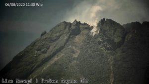
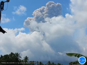
Indonesia , Semeru :
VOLCANO OBSERVATORY NOTICE FOR AVIATION – VONA.
Issued: April 11 , 2020 .
Volcano: Semeru (263300)
Current Aviation Colour Code: ORANGE
Previous Aviation Colour Code: orange
Source: Semeru Volcano Observatory
Notice Number: 2020SMR21
Volcano Location: S 08 deg 06 min 29 sec E 112 deg 55 min 12 sec
Area: East java, Indonesia
Summit Elevation: 11763 FT (3676 M)
Volcanic Activity Summary:
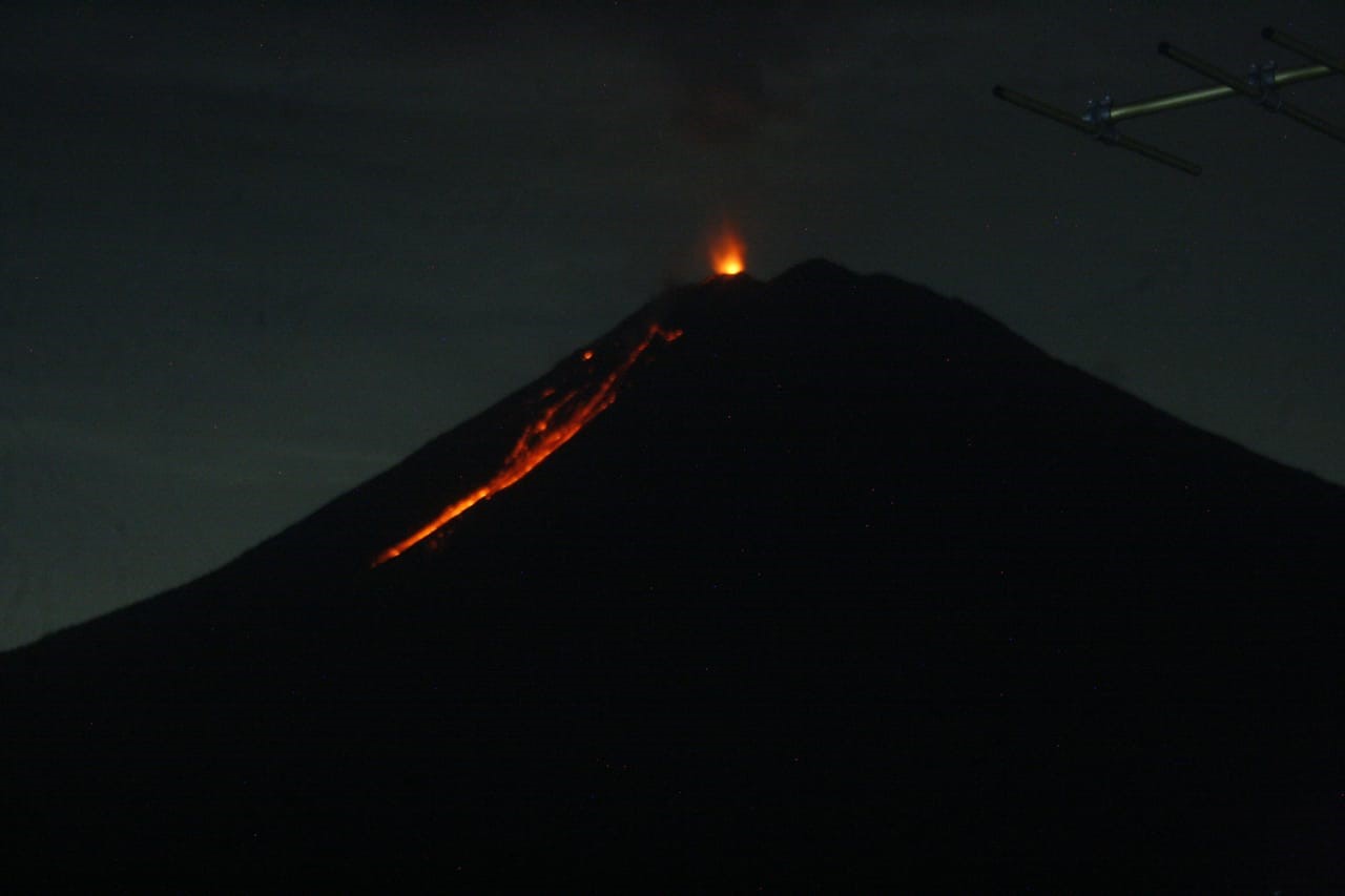
Eruption with volcanic ash cloud at 02h22 UTC (09h22 local).
Volcanic Cloud Height:
Best estimate of ash-cloud top is around 13043 FT (4076 M) above sea level, may be higher than what can be observed clearly. Source of height data: ground observer.
Other Volcanic Cloud Information:
Ash cloud moving to north
Remarks:
Seismic activity is characterized by eruption, avalanche and gas emission earthquakes
Source : Magma Indonésie .
Photo : pvmbg.
Alaska , Shishaldin :
54°45’19 » N 163°58’16 » W,
Summit Elevation 9373 ft (2857 m)
Current Volcano Alert Level: WATCH
Current Aviation Color Code: ORANGE
Seismicity remains above background at Shishaldin, with weak low-frequency earthquakes occurring intermittently over the past week. On several days this week, minor steaming from the summit crater was observed in satellite and web camera imagery. Satellite imagery also showed weakly to moderately elevated surface temperatures at the summit. Any continuing eruptive activity is currently low-level and confined to the summit area, which has been the case during this most recent period of unrest that started mid-March. Activity could increase with little or no warning, however, resulting in lava flows outside of the crater, lahars, and ash emissions.
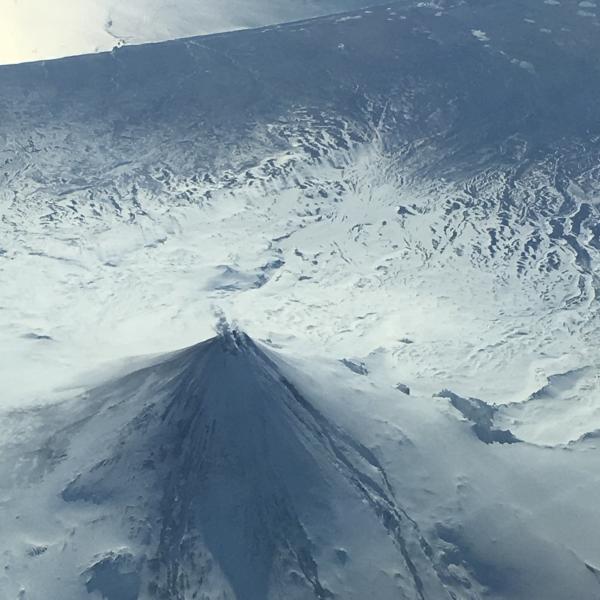
Oblique aerial photo of Shishaldin Volcano taken on March 11, 2020 on and Alaska Airlines flight from Adak to Anchorage, Alaska. Minor steaming from the summit crater is seen. Erosion of the snow and ice on the upper flanks or the volcano can be seen and is the result of lava flows from eruptive activity in late 2019 to early 2020.
Shishaldin is monitored by local seismic and infrasound sensors, satellite data, web cameras, a telemetered geodetic and tilt network, and distant infrasound and lightning networks.
Shishaldin volcano, located near the center of Unimak Island in the eastern Aleutian Islands, is a spectacular symmetric cone with a base diameter of approximately 16 km (10 mi). A 200-m-wide (660 ft) funnel-shaped summit crater typically emits a steam plume and occasional small amounts of ash. Shishaldin is one of the most active volcanoes in the Aleutian volcanic arc, with at least 54 episodes of unrest including over 24 confirmed eruptions since 1775. Most eruptions are relatively small, although the April-May 1999 event generated an ash column that reached 45,000 ft above sea level.
Source : AVO.
Photo : Fischer, Ed
Mexico , Popocatepetl :
April 10, 11:00 a.m. (April 09, 4:00 p.m. GMT)
In the past 24 hours, using the Popocatépetl volcano monitoring system, 137 exhalations have been identified, accompanied by water vapor, volcanic gases and small amounts of ash.
Likewise, two explosions were recorded, the first at 03:48 h, with emission of fragments on the slopes of the volcano and at 06:21 h, which also emitted incandescent fragments.
In addition, 266 minutes of low amplitude tremors and two volcano-tectonic earthquakes were recorded yesterday at 22:48 h, and today at 03:23 h, with a preliminary magnitude of M1.9.
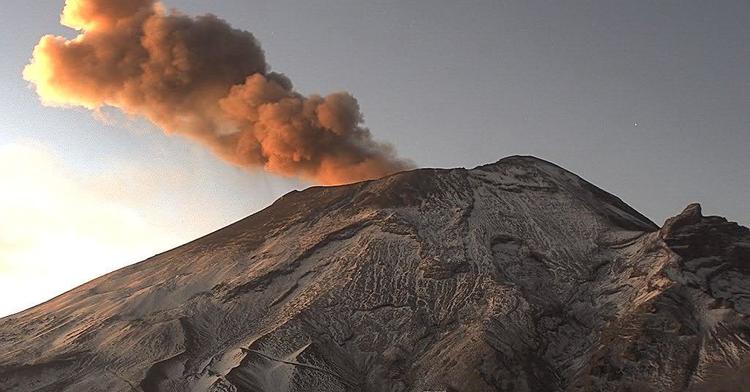
At the time of this report, there is no visibility of the volcano due to cloud cover, however, in the early hours of the morning, the emission of volcanic gases and light amounts of ash scattered to the Northeast could be observed.
CENAPRED urges NOT to get close to the volcano and especially the crater, because of the danger involved in the fall of ballistic fragments, and, in the event of heavy rain, to move away from the bottom of the ravines because of the danger of flows mud and rubble.
The Popocatépetl volcanic alert signaling light is in YELLOW PHASE 2.
Source : Cenapred .