June 07 , 2022.
Indonesia , Ibu :
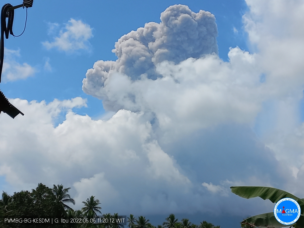
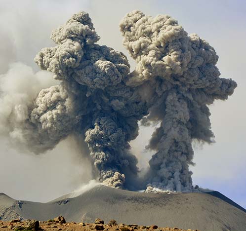
Mount Ibu erupted on Monday, June 6, 2022 at 11:16 a.m. WIT with an ash column height observed at ± 4000 m above the summit (± 5325 m above sea level). The ash column is observed to be gray with a strong intensity, thick, oriented towards the West. This eruption was recorded on a seismograph with a maximum amplitude of 30 mm and a duration of 184 seconds.
Recommendation
Communities around Mount Ibu and visitors/tourists are advised not to travel within 2.0 km. A sectoral expansion is in place, from 3.5 km to the crater opening in the northern part of the active Mount Ibu crater.
In the event of ash rain, people who are active outside the home are advised to use nose, mouth (mask) and eye (goggles) protection.
VOLCANO OBSERVATORY NOTICE FOR AVIATION – VONA
Issued : 06 Juin 2022
Volcano : Ibu (268030)
Current Aviation Colour Code : ORANGE
Previous Aviation Colour Code : orange
Source : Ibu Volcano Observatory
Notice Number : 2022IBU37
Volcano Location : N 01 deg 29 min 17 sec E 127 deg 37 min 48 sec
Area : North Maluku, Indonesia
Summit Elevation : 4240 FT (1325 M)
Volcanic Activity Summary :
Eruption with volcanic ash cloud at 02h16 UTC (11h16 local).
Volcanic Cloud Height :
Best estimate of ash-cloud top is around 17040 FT (5325 M) above sea level, may be higher than what can be observed clearly. Source of height data: ground observer.
Other Volcanic Cloud Information :
Ash-cloud moving to southeast.
Remarks :
Eruption and ash emission is continuing.
Source : Magma Indonésie.
Peru , Sabancaya :
Analysis period: from May 30, 2022 to June 05, 2022, Arequipa, June 06, 2022.
Alert level: ORANGE
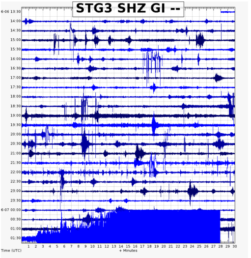
The Geophysical Institute of Peru (IGP) reports that the eruptive activity of the Sabancaya volcano remains at moderate levels, that is to say with the recording of an average of 9 daily explosions, with columns of ash and of gas up to 1.5 km altitude above the summit of the volcano and their subsequent dispersion. Therefore, for the following days, no significant change is expected in eruptive activity.
The IGP recorded and analyzed the occurrence of 230 earthquakes of volcanic origin, associated with the circulation of magmatic fluids inside the Sabancaya volcano. An average of 9 explosions was recorded daily, in addition to recording Volcano-Tectonic (VT) type events associated with rock fracturing inside the Sabancaya volcano.
Monitoring the deformation of the volcanic structure using GNSS techniques (processed with fast orbits) does not show any significant anomalies. However, in general, an inflation process has been observed in the northern sector (surroundings of the Hualca Hualca volcano). Visual surveillance identified columns of gas and ash up to 1.5 km above the summit of the volcano, which were scattered towards the eastern and southeastern sectors of Sabancaya. Satellite recordings have identified the presence of 6 thermal anomalies, with a maximum value of 9 MW, associated with the presence of a lava body on the surface of the volcano’s crater.
RECOMMENDATIONS
• Keep the volcanic alert level orange.
• Do not approach within a radius of less than 12 km from the crater.
Source : Cenvul
Photo : IGP.
Italy , Stromboli :
Communication on Stromboli activity, June 06, 2022, 22:29 (20:29 UTC)
The National Institute of Geophysics and Volcanology, Osservatorio Etneo reports that monitoring networks recorded an anomalous seismic signal at 22:27 (20:27 UTC).
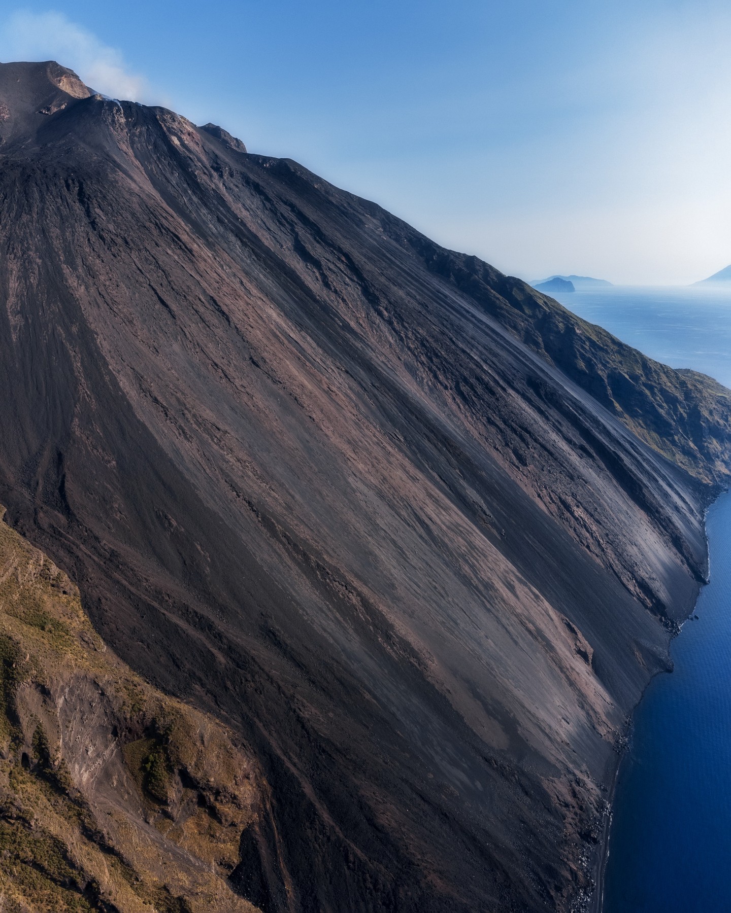
Communication on Stromboli activity, June 06, 2022, 23:04 (21:04 UTC)
The National Institute of Geophysics and Volcanology, Osservatorio Etneo announces that from 8:21 p.m. to 8:29 p.m. UTC the seismic stations of Stromboli recorded a seismic signal, associated with two landslides. The trend of the average amplitude of the volcanic tremor did not undergo significant variations.
During landslides, the analysis of the images from the INGV-OE surveillance cameras revealed a weak projection activity in the area of the North crater.
From the analysis of the ground deformation data, no significant variation in the signals from the tilt and GNSS networks is evident.
Further updates will be communicated promptly and in any case within 3 hours of this press release.
At 23:40 (21:40 UTC), the settings return to normal activity.
Source : INGV.
Photo : Giantaranto
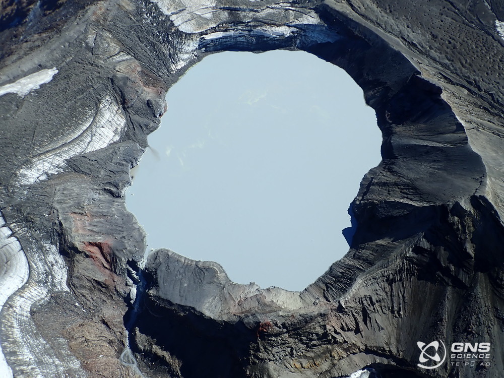
New Zealand , Ruapehu :
Lower level of activity at Mt Ruapehu. Published: Tue Jun 7 2022 2:30 PM
The Volcanic Alert Level remains at Level 2.
Aviation Colour Code remains at Yellow
The level of volcanic unrest at Mt Ruapehu has decreased from heightened to moderate, however the potential for eruptions remains.
Volcanic tremor strength at Mt Ruapehu has declined to weak levels over the past week.
Crater Lake (Te Wai ā-moe) temperature is currently 28 °C and has continued its slow cooling trend over the past 3 to 4 weeks. Heat flow calculations indicate that heat entering the lake is around 100-160 MW, down from 300-400 MW last month. The lake level has also responded to the heavy rainfall over the past week, with an increase in overflow.
Although weather conditions have not allowed gas measurement flights in the last few weeks, the last relatively high sulphur dioxide (SO2) and carbon dioxide (CO2) measurements are consistent with a continued period of moderate volcanic unrest at Mt Ruapehu.
The level of unrest is now considered moderate rather than heightened, however the potential for eruptive activity remains.
Scenarios
Within the next three weeks, the most likely outcomes of the ongoing unrest are either minor eruptive activity that is confined to the lake basin, or no eruption. Minor eruptions may generate lahars (dangerous volcanic mudflows) in the Whangaehu River.
The next likely scenario is a larger eruption that impacts the summit plateau with volcanic surges. That event could generate lahars in multiple catchments, like what was seen after the September 2007 eruption, or like those in June 1969. An eruption of this size would cause life-threatening hazards on the summit plateau and in valleys impacted by lahars.
The chance of a prolonged eruptive episode or a larger eruption, with wider ashfall impacts such as occurred in 1995-96, is higher than it was before the start of elevated unrest in March 2022, but within the next three weeks remains very unlikely. Such an eruption would most likely only follow a sequence of smaller eruptions.
Summary
The level of volcanic unrest has declined from heightened to moderate at Mt Ruapehu. GNS Science staff are carrying out more frequent aerial observations and gas measurements when weather conditions are suitable.
Our interpretation of the observational data and activity is consistent with moderate volcanic unrest and therefore the Volcanic Alert Level remains at Level 2. The Aviation Colour Code remains at Yellow.
Mt Ruapehu is an active volcano and has the potential to erupt with little or no warning when in a state of moderate volcanic unrest.
Source : Geonet / Craig Miller / Duty Volcanologist.
Photo : Geonet.
Guatemala , Santiaguito :
LAHAR IN THE CABELLO DE ÁNGEL RIVER, TRIBUTARY OF THE NIMÁ I RIVER
Currently, heavy rains are being generated in the area of the Santa María-Santiaguito volcanic complex, which causes lahars to descend into the Cabello de Ángel river, a tributary of the Nimá I river. In its descent, the lahar has the characteristics low, it can transport pasty volcanic materials, similar to a mixture of cement, accompanied by water, blocks of rock up to 1 meter in diameter, trunks, tree branches and fine materials which are incorporate on its way.
The lahar may increase its intensity from weak to moderate in the next few minutes and, if these rainy conditions persist in the region, the possibility of lahars descending in one of the channels that descend from the volcanic complex is not excluded. INSIVUMEH maintains visual and instrumental monitoring of volcanic activity through its field observers, seismic stations and web cameras.
Source : Insivumeh.