October 16 , 2023.
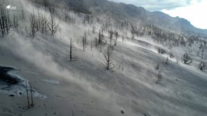
Alaska , Shishaldin :
AVO/USGS Volcanic Activity Notice
Current Volcano Alert Level: WATCH
Current Aviation Color Code: ORANGE
Issued: Sunday, October 15, 2023, 12:43 PM AKDT
Source: Alaska Volcano Observatory
Notice Number: 2023/A1505
Location: N 54 deg 45 min W 163 deg 58 min
Elevation: 9373 ft (2857 m)
Area: Aleutians
Volcanic Activity Summary:
Clear web camera views of Shishaldin from yesterday and today show a robust vapor cloud at the volcano’s summit. This vapor plume likely consists primarily of steam and other volcanic gases. The vapor cloud does not indicate that an eruption is in progress and probably reflects the interaction of hot material and snow and ice. The Aviation Color Code remains at ORANGE and the Volcano Alert Level at WATCH.
Shishaldin Volcano is monitored by local seismic and infrasound sensors, web cameras, and a telemetered geodetic network. In addition to the local monitoring network, AVO uses nearby geophysical networks, regional infrasound and lighting data, and satellite images to detect eruptions.
Recent Observations:
[Volcanic cloud height] 10,000 to 20,000 feet above sea level
[Other volcanic cloud information] Unknown
Hazard Analysis:
[Volcanic gas] Possible sulfur dioxide emissions
Remarks:
Shishaldin Volcano, located near the center of Unimak Island in the eastern Aleutian Islands, is a spectacular symmetric cone with a base diameter of approximately 10 miles (16 km). A 660 ft. (200 m) wide funnel-shaped summit crater typically emits a steam plume and occasional small amounts of ash. Shishaldin is one of the most active volcanoes in the Aleutian volcanic arc, with at least 54 episodes of unrest including over 26 confirmed eruptions since 1824. Most eruptions are relatively small, although the April-May 1999 event generated an ash column that reached 45,000 ft. (14 km) above sea level.
Source : AVO
Photo : Barnes, Chris
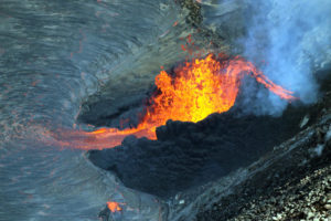
Kamchatka , Klyuchevskoy :
VOLCANO OBSERVATORY NOTICE FOR AVIATION (VONA)
Issued: October 16 , 2023
Volcano: Klyuchevskoy (CAVW #300260)
Current aviation colour code: ORANGE
Previous aviation colour code: orange
Source: KVERT
Notice Number: 2023-112
Volcano Location: N 56 deg 3 min E 160 deg 38 min
Area: Kamchatka, Russia
Summit Elevation: 4750 m (15580 ft)
Volcanic Activity Summary:
The summit explosive-effusive eruption of the volcano continues. Against the background of explosive activity of the Strombolian type (lava fountaining in the volcanic crater), the lava flows continue to effuse along the Apakhonchichsky chute on the southeastern slope of the volcano. Lava flows in the Apakhonchichsky chute melt buried snowfields and glaciers. Powerful phreatic explosions are observed in the Apakhonchichsky chute, and large collapses of pyroclastic material from its sides. Satellite data by KVERT showed an ash plume is extending for 70 km to the northeast of the volcano.
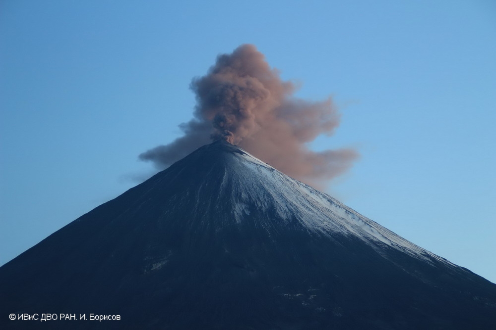
The summit explosive-effusive eruption of the volcano continues. Ash explosions up to 7-8 km (23,000-26,240 ft) a.s.l. could occur at any time. Ongoing activity could affect international and low-flying aircraft.
Volcanic cloud height:
6500-7000 m (21320-22960 ft) AMSL Time and method of ash plume/cloud height determination: 20231016/0330Z – Video data
Other volcanic cloud information:
Distance of ash plume/cloud of the volcano: 70 km (43 mi)
Direction of drift of ash plume/cloud of the volcano: ENE / azimuth 65 deg
Time and method of ash plume/cloud determination: 20231016/0300Z – Himawari-9 14m15
Source : Kvert
Photo : I. Borisov, IVS FEB RAS ( archive).
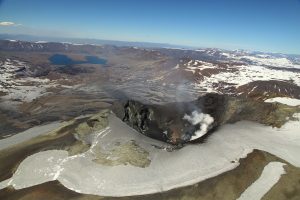
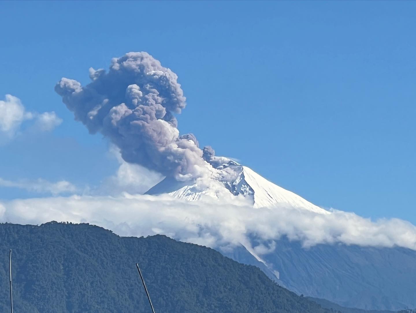
Ecuador , Sangay :
DAILY REPORT ON THE STATE OF THE SANGAY VOLCANO, Sunday October 15, 2023.
Information Geophysical Institute – EPN.
Surface activity level: High, Surface trend: No changes
Internal activity level: High, Internal trend: No changes
Seismicity: From October 14, 2023, 11:00 a.m. to October 15, 2023, 11:00 a.m.:
The number of seismic events recorded at the reference station over the past 24 hours is shown below. The level of seismic activity of the volcano remains high.
Explosion Event (EXP): 292
Precipitation/Lahars:
No rain was recorded in the volcano area. In the event of heavy rains, these could remobilize the accumulated materials, generating mud and debris flows which would descend the sides of the volcano and flow into adjacent rivers.
Emissions/ash column:
Yesterday afternoon and today morning, 2 emissions of gas and ash were observed with heights up to 1500 m above sea level with directions between the west and the northwest.
Observation:
The volcano remained generally cloudy, however, for brief moments in the early morning, incandescence was observed at the crater.
Other monitoring parameters:
The FIRMS satellite system has recorded 2 thermal alerts in the last 24 hours.
Alert level: yellow
Source : IGEPN.
Photo : AdriáLou Garay Véle
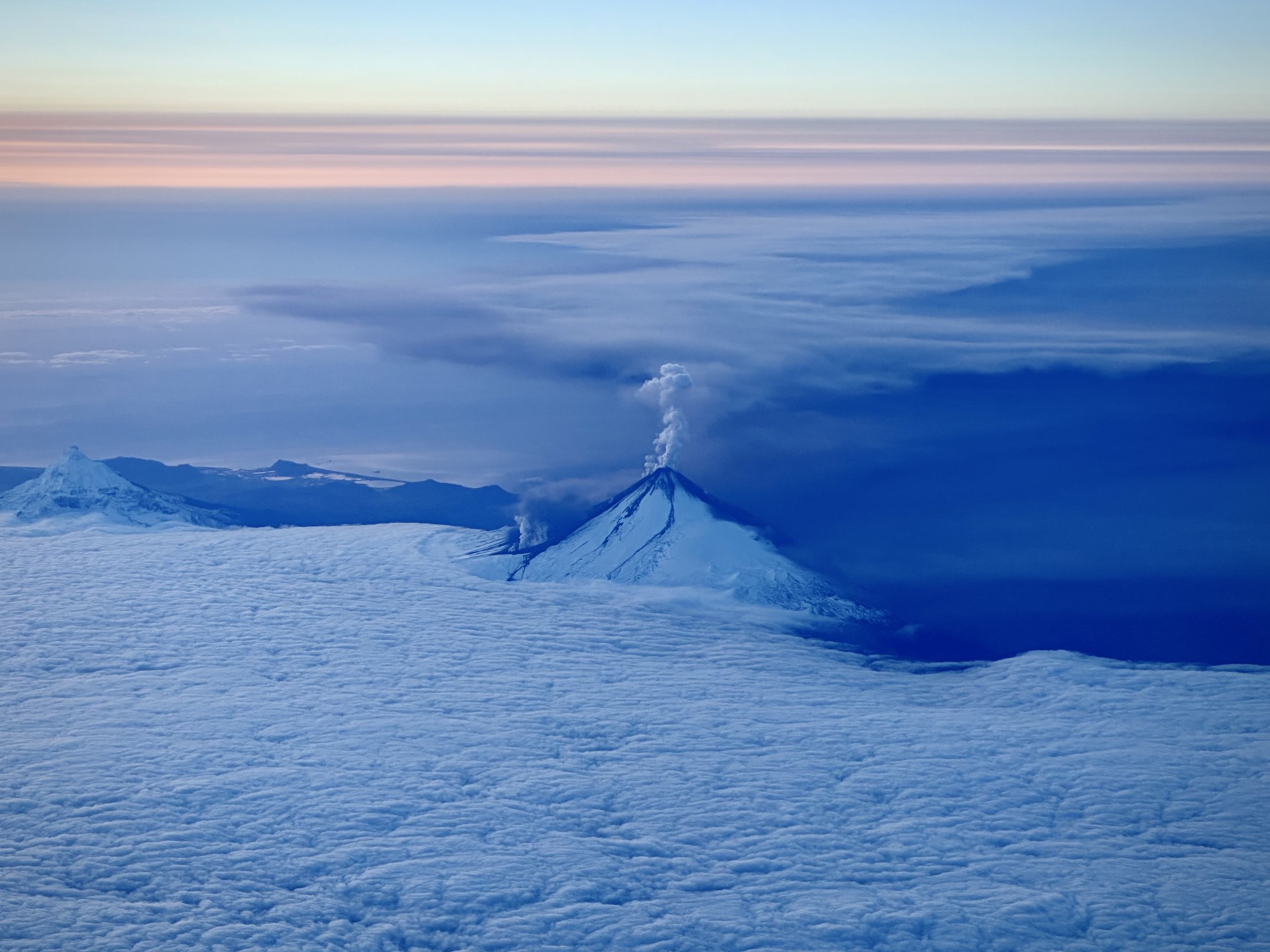
Hawaii , Kilauea :
Sunday, October 15, 2023, 8:28 AM HST (Sunday, October 15, 2023, 18:28 UTC)
19°25’16 » N 155°17’13 » W,
Summit Elevation 4091 ft (1247 m)
Current Volcano Alert Level: ADVISORY
Current Aviation Color Code: YELLOW
Activity Summary:
Kīlauea volcano is not erupting. Earthquake and ground deformation rates beneath the southern part of Kīlauea’s summit caldera and extending to the southwest have decreased dramatically over the past several days, suggesting the intrusive event that began last week is coming to an end.
Summit Observations:
The major intrusive event that has been ongoing beneath the area extending from the southern part of Kīlauea caldera southwest to the Koaʻe fault zone appears to have slowed significantly or stopped. A dramatic drop in earthquakes, from a peak of over 250 per day last week, to only 23 recorded in the past 24 hours. These earthquakes were at depths of 1-5 km (0.6-3 mi) beneath the surface.
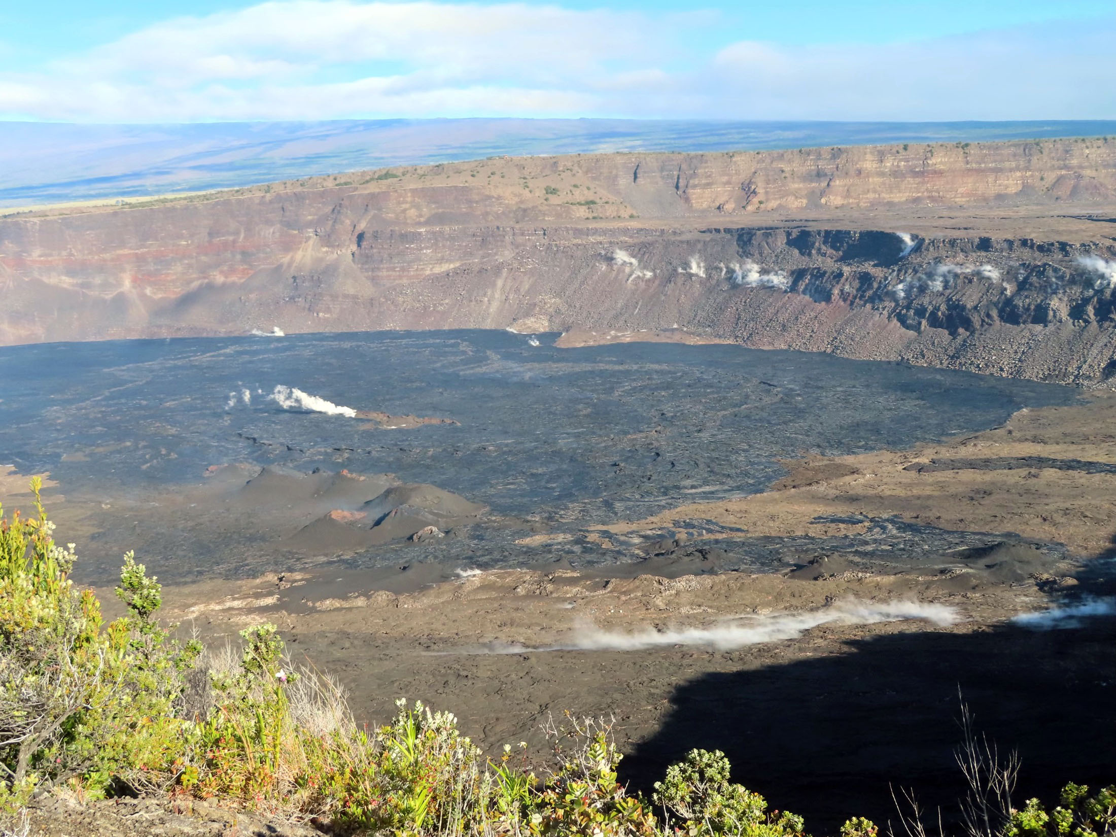
Summit tiltmeters recorded a change in tilt magnitude and direction, in the past several days, away from the seismically active area, thus signaling ground deformation associated with the intrusive event ceased. These observations suggest that new magma supply to the intrusion below the surface south of Kīlauea’s summit caldera has slowed greatly or stopped. However, inflation at the summit of Kīlauea remains high and has nearly returned to the level seen just before the last eruption on September 10th.
Currently, the Uēkahuna summit tiltmeter located north of the caldera recorded very slight deflation over the past 24 hours. The Sand Hill tiltmeter, located just south of the caldera, is showing a flat tilt trend. Sulfur dioxide (SO2) emission rates remain low and were measured at a rate of about 100 tonnes per day on October 6. Other monitoring data streams, including webcam views, do not show any significant changes.
Inflation at the summit of Kīlauea remains high, and seismicity and ground deformation rates are likely to begin increasing again in the near future. HVO continues to monitor the summit region of Kīlauea volcano closely.
Source : HVO
Photo : USGS / J. Chang.
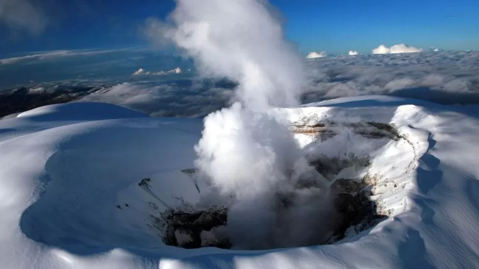
Colombia , Nevado del Ruiz :
Weekly bulletin on the activity of the Nevado del Ruiz volcano
From the monitoring of the activity of the NEVADO DEL RUIZ VOLCANO, the MINISTRY OF MINES AND ENERGY through the COLOMBIAN GEOLOGICAL SERVICE (SGC) reports that:
In the week of October 3-9, 2023, the volcano continued to exhibit instability in its behavior, with low to slightly moderate activity levels. Compared to the previous week, the main variations in the parameters monitored were:
– Seismicity linked to fluid dynamics inside volcanic conduits has increased in the number of earthquakes recorded and in the seismic energy released. Most of these seismic signals had low to sometimes moderate energy levels and were primarily associated with pulsatile emissions of ash and gas into the atmosphere. The recording of signals associated with the emission of ash continues during October 5, between 05:43 and 07:10, and October 9 from 21:09. until October 10 at 8:06 a.m. stands out.
Accompanying the pulsatile or continuous emission of ash, changes in the relative temperature of the emitted material, as well as incandescence, have sometimes been observed. These phenomena were confirmed thanks to the cameras used to monitor the volcano.
– Seismic activity associated with the fracturing of rocks within the volcanic edifice has decreased significantly in terms of the number of earthquakes recorded and seismic energy released. The earthquakes were located in the Arenas crater and scattered on the different flanks of the volcano, up to a maximum distance of approximately 12 km from the crater. The depths of the earthquakes varied between less than 1 and 9 km, relative to the summit of the volcano. The maximum magnitude recorded was 1.3, corresponding to the earthquake recorded yesterday October 9 at 7:27 p.m., located in the Arenas crater at a depth of 1.6 km. Additionally, on October 6 and 8, low energy seismicity was recorded related to the activity of the lava dome (protrusion or mound) located at the bottom of the crater.
– The emission of water vapor and gases into the atmosphere continued with sulfur dioxide (SO2) outgassing rates slightly higher than those of the previous week, reflecting the increasing trend that is is produced in this process in recent weeks. The maximum height of the vertically dispersed gas and ash column was 2000 m, these values were measured at the summit of the volcano on October 4 and 9 respectively.
Source et photo : SGC