February 13 , 2020 .
La Réunion , Piton de la Fournaise :
21.244°S, 55.708°E
Elevation 2632 m
OVPF reported that a seismic crisis at Piton de la Fournaise began at 1027 on 10 February, accompanied by rapid deformation. Volcanic tremor began just 23 minutes later, at 1050, heralding the start of a new eruption. During an overflight conducted during 1300-1330 in partly cloudy weather, observers noted that several fissures had opened on the E flank of Dolomieu Crater, between the crater rim and 2,000 m elevation. The fissures all were at least 1 km long and produced lava fountains that were no higher than 10 m.
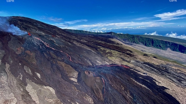
Lava flows had traveled E to 1,700 m elevation by 1315. In the evening mapping of the lava flows based on satellite data revealed a larger flow field that what was visually observed during the overflight hours before. Lava flows spanned from the E to the S, with the farthest flow traveling E to 1,400 m elevation. The data showed that the fissures at the highest elevation had opened in the same area as those from the 18 February and 11 June 2019 eruptions.
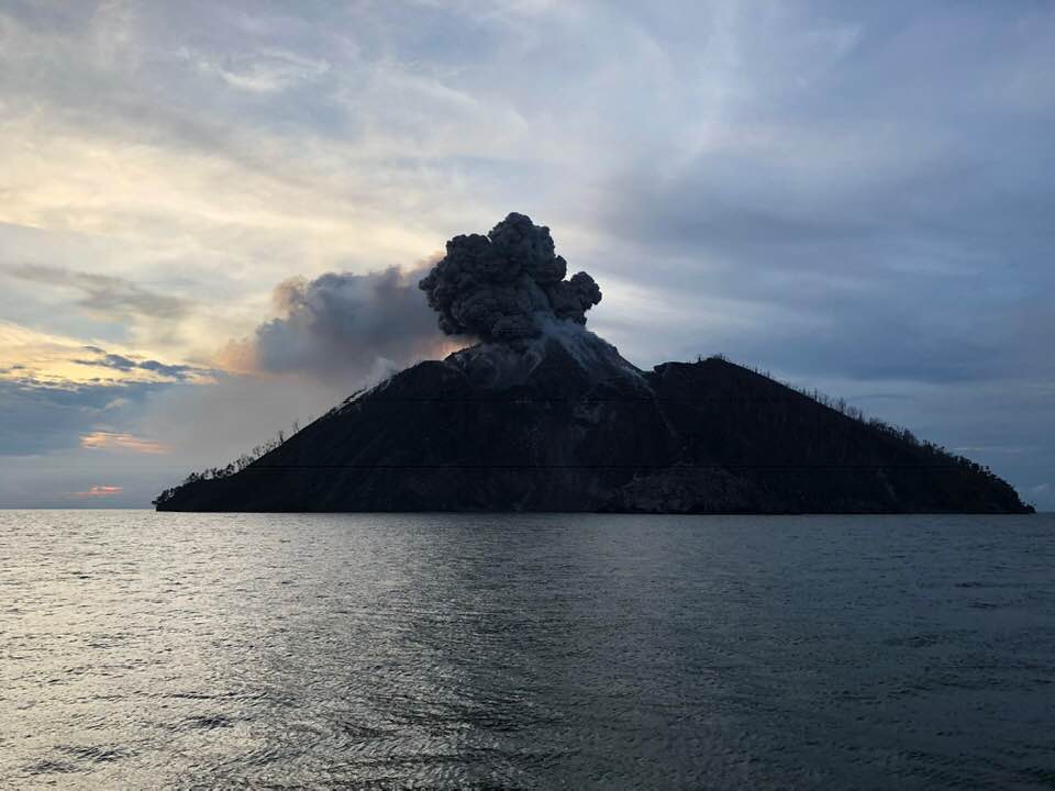
The Piton de la Fournaise continues to pour its lava flows this Thursday morning February 13, 2020. According to the volcanological observatory (OVPF), « the eruption is in great shape ». The observatory was also (finally) able to take samples from the volcano, thanks to a milder weather. The show remains magnificent as shown by these photos and videos made by Imaz Press this Thursday morning (Photos rb / www.ipreunion.com).
« The eruption is in great shape » explains Nicolas Villeneuve of the OVPF. A new overview this Thursday revealed that two flows started from the eruptive mouth. « The first, further south, will stop, while the second, further north, descends towards the hut on the eastern flank, cuts the rescue trail and descends to approximately 1900 meters above sea level. »
Currently, the casting front is located in a flatter area. The flow is relatively low, so there is little chance that lava will hit the road.
« The devices tell us that it is a relatively classic eruption, with a strong degassing at the beginning and a lot of energy in the seismicity. It has calmed down and remains constant » indicates Nicolas Villeneuve. « From what we have seen on the ground, it is sure that it is an eruption in good shape. The flow is not strong but there is speed linked to the slope and the flows are really well marked. «
Source: Volcanological Observatory of Piton de la Fournaise (OVPF) , GVP , ipreunion.com .
Lire l’article : http://www.ipreunion.com/volcan/reportage/2020/02/13/-photos-videos-volcan-le-piton-de-la-fournaise-la-lave-continue-de-tracer-sa-route,114635.html
Indonesia , Merapi :
VOLCANO OBSERVATORY NOTICE FOR AVIATION – VONA .
Issued: February 12 , 2020
Volcano: Merapi (263250)
Current Aviation Colour Code: ORANGE
Previous Aviation Colour Code: unassigned
Source: Merapi Volcano Observatory
Notice Number: 2020MER01
Volcano Location: S 07 deg 32 min 31 sec E 110 deg 26 min 31 sec
Area: Special Region of Yogyakarta, Indonesia
Summit Elevation: 9498 FT (2968 M)
Volcanic Activity Summary:
Eruption with volcanic ash cloud at 22h16 UTC (05h16 local). The eruption lasted for 105 seconds
Volcanic Cloud Height:
Best estimate of ash-cloud top is around 15898 FT (4968 M) above sea level, may be higher than what can be observed clearly. Source of height data: ground observer.
Other Volcanic Cloud Information:
Ash-cloud moving to northwest.
Remarks:
Eruption recorded on the seismogram with amplitude max 75 mm and 105 second duration.
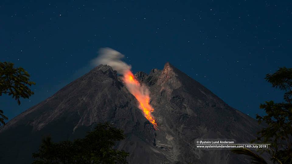
Chronological press release of the Merapi volcano eruption on February 13, 2020
Explosive eruptions again occurred on February 13, 2020 at 5:16 a.m., Western Indonesia time, recorded on a seismograph with an amplitude of 75 mm and a duration of 150 seconds. An eruption with projection of material was observed within a radius of 1 km around the summit. The column of eruption smoke was observed up to 2 km altitude, which, with the wind headed towards the North-West (photo attached). To anticipate the disturbance of volcanic ash on flights, the VONA (Volcano Observatory Notice for Aviation) was issued with the color code Orange. Ash rains have been reported around Mount Merapi within a radius of 10 km, mainly in the southern sector, in the villages of Hargobinangun, Glagaharjo and Kepuharjo.
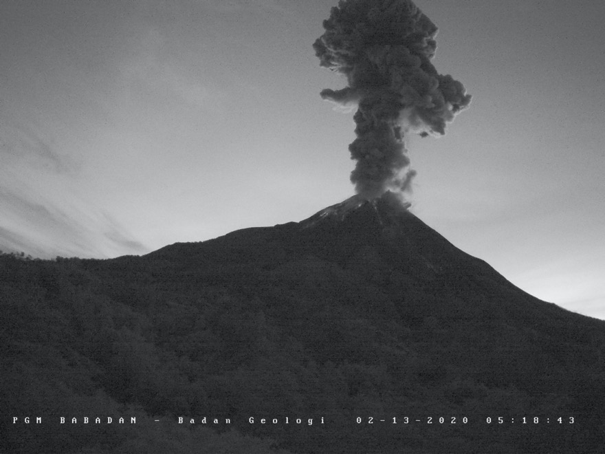
Before that, in September-November 2019, there were 4 explosive eruptions accompanied by deep volcanic seismic activity (> 1.5 km). From mid-December 2019 to mid-January 2020, there was an increase in deep volcanic seismic activity, followed by an increase in surface activity such as earthquake / rock fall (RF) , emission / degassing (DG, low frequency LF, multiphase (MP), and shallow volcano – tectonic activity (VTB)). After that comes the February 13, 2020 eruption. These observation data show the continuation of the magma intrusion activity towards the surface, which is the 7th phase in the chronology of the eruptive activity of Mont Merapi 2018-2020.
This type of eruption can always occur to indicate that the supply of magma to the magma chamber is still in progress. The danger of this eruption is expressed in the form of emission of volcanic material and hot clouds with a range <3 km from the discharge of material from the lava dome.
Communities must remain calm and do their activities as usual outside the 3 km radius from the summit of Mount Merapi.
Source : Magma Indonésie , Hanik Humaida / Responsable BPPTKG.
Photos : Oystein Lund Andersen , BPPTKG .
Japan , Kuchinoerabujima :
30.443°N, 130.217°E
Elevation 657 m
JMA reported that after the 3 February eruption at Kuchinoerabujima’s Shindake Crater the number of volcanic earthquakes decreased, and very small eruptive events occurred intermittently though 5 February and on 9 February. A large amount of ashfall (including lapilli up to 2 cm in diameter) was confirmed on the SE flank during field observations on 3 and 6 February.
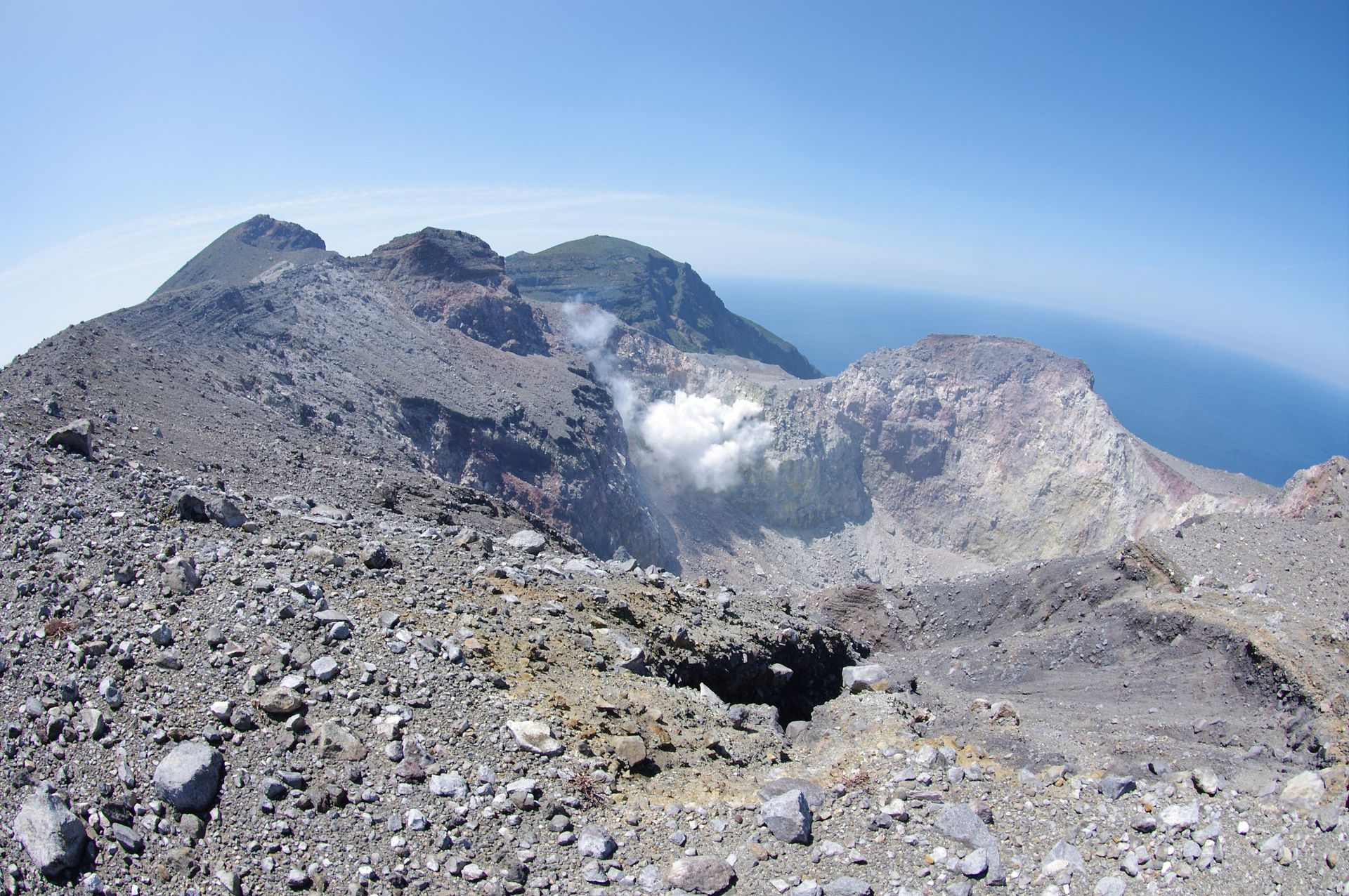
Thermal image observations revealed 5-km-long pyroclastic flow deposits on the SW flank. The number of volcanic earthquakes began increasing on 9 February and continued to be elevated the next day. A large-amplitude volcanic tremor event was accompanied by fluctuating tilt at 1318 on 11 February. The Alert Level remained at 3 (the middle level on a scale of 1-5).
Source : JMA, GVP.
Photo : Tsuda — Flickr: Kuchino-erabu island (volcano), CC BY-SA 2.0, https://commons.wikimedia.
Papua – New – Guinea , Kadovar :
3.608°S, 144.588°E
Elevation : 365 m
RVO reported that the eruption at Kadovar continued during 1 January-7 February with frequent (hours to days) Vulcanian explosions from Main Vent at the summit. The explosions ejected rocks and ash plumes that rose 300-400 m above the vent and drifted Noth-East and East.
Residents on Blup Blup (15 km N) reported rumbling and nighttime summit incandescence. Volcanic plumes were sometimes observable in Wewak (105 km W). The Darwin VAAC stated that on 6 February an ash plume rose to 2.1 km (7,000 ft) a.s.l. and drifted South-East .
Sources: Rabaul Volcano Observatory (RVO), Darwin Volcanic Ash Advisory Center (VAAC).
Photo : Philip Stern , décembre 2018 .
Mexico , Michoacan :
CENAPRED and UNAM meet and report an earthquake swarm in the Michoacán area
The public is invited to obtain information from official sources on the results of research carried out by CENAPRED and universities
In order to assess the seismic swarm recorded in Michoacán since the beginning of January, an extraordinary meeting of the scientific advisory committee SINAPROC of the Popocatepetl volcano was held yesterday, made up of specialists from the National Center for Disaster Prevention (CENAPRED) and the National University Autonomous Region of Mexico, to which researchers from other universities and institutions were invited.
In the Northwest region of Uruapan, more than 2,080 earthquakes of magnitude between 3.1 and 4.1 have been reported until yesterday, which are relatively weak and have not been perceived by the population. , they therefore do not represent a danger for the inhabitants of the region.
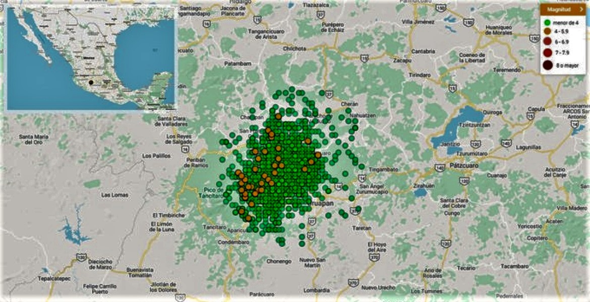
It should be noted that similar swarms were recorded in this area in 1997, 2000 and 2006, without such activity leading to a volcanic eruption or a more significant earthquake.
With the information available to date, it is possible that the seismic swarm has a magmatic origin, similar to what happened in 2006, without necessarily implying the birth of a volcano.
Thus, around fifty specialists from CENAPRED, geophysics, engineering institutes, the Faculty of Engineering and the Geosciences Center of UNAM; from the University of Colima and the Michoacana University of San Nicolás de Hidalgo are conducting studies in the region. They installed measuring equipment, analyzed water and gas samples and monitored soil deformation. This instrumentation will be reinforced soon.
On the basis of the results of the continuous monitoring of the activity, the participating institutions will quickly inform the civil protection authorities and the population, it is therefore recommended to consult the official sources of information.
Source : Cenapred .