January 23 , 2020 .
Philippines , Taal :
TAAL VOLCANO BULLETIN 23 January 2020 8:00 A.M.
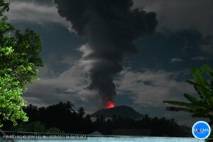
Activity in the Main Crater in the past 24 hours has been characterized by weak to moderate emission of white steam-laden plumes 50 to 500 meters high from the Main Crater that drifted southwest. Sulfur dioxide (SO2) emission was measured at an average of 141 tonnes/day.
The Philippine Seismic Network (PSN) plotted a total of seven hundred thirty-one (731) volcanic earthquakes since 1:00 PM, January 12, 2020. One hundred seventy-six (176) of these registered at magnitudes M1.2-M4.1 and were felt at Intensities I-V. Since 5:00 AM on January 22, 2020 until 5:00 AM today, there were six (6) volcanic earthquakes plotted that registered at magnitudes M1.5-M3.4 with no felt event.

Amazing photo of the ash covered Taal Volcano from astronaut Christina Koch up on the International Space Station. The plume of dust from the volcano blowing into Agoncillo and Lemery is thick enough to be seen from space.
For the past 24 hours, the Taal Volcano Network, which can record small earthquakes undetectable by the PSN, recorded four hundred sixty-seven (467) volcanic earthquakes including eight (8) low-frequency earthquakes. Such intense activity likely signifies continuous magmatic intrusion beneath the Taal edifice, which may lead to further eruptive activity.
Alert Level 4 still remains in effect over Taal Volcano. This means that hazardous explosive eruption is possible within hours to days. DOST-PHIVOLCS strongly reiterates total evacuation of Taal Volcano Island and high-risk areas as identified in the hazard maps within the 14-km radius from Taal Main Crater and along the Pansipit River Valley where fissuring has been observed. Based on PAGASA wind forecast, if the eruption plume remains below five (5) km, ash will be drifted to the municipalities west and northwest of the Main Crater; however, if a major eruption occurs during the day and the eruption column exceeds 7 km, ash will also be drifted over some parts of Laguna and Quezon provinces. Residents around the volcano are advised to guard against the effects of heavy and prolonged ashfall. Civil aviation authorities must advise pilots to avoid the airspace around Taal Volcano as airborne ash and ballistic fragments from the eruption column pose hazards to aircraft.
DOST-PHIVOLCS is continually monitoring the eruption and will update all stakeholders of further developments.
According to the Disaster Response Operations Monitoring and Information Center (DROMIC) there were a total of 148,987 people in 493 evacuation centers as of 1800 on 21 January.
Source : Phivolcs , GVP.
Photos : Christina Koch , Raffy Tima .
Italy / Sicily , Etna :
Weekly bulletin from 13/01/2020 to 19/01/2020 (date of issue 21/01/2020)
SUMMARY OF ACTIVITY STATUS
In light of the monitoring data, it is highlighted:
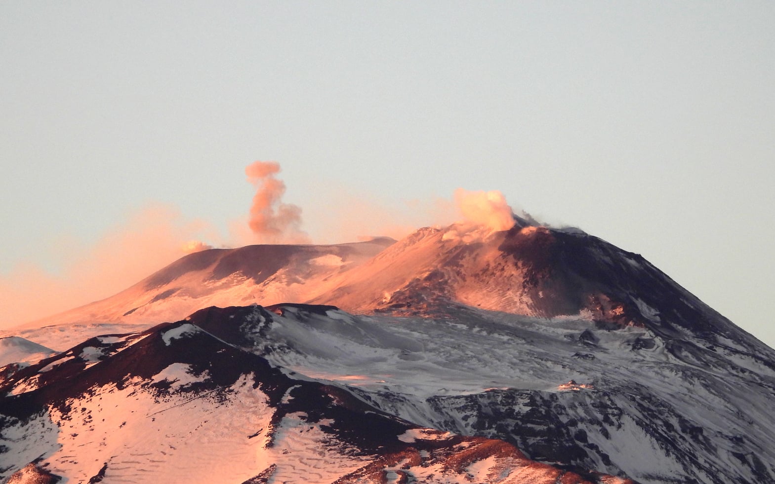
1) VOLCANOLOGICAL OBSERVATIONS: Strombolian intra-crater activity and ash emissions from the Voragine crater, the New Southeast Crater and the Northeast Crater.
2) SEISMOLOGY: Modest seismic fracturing activity; moderate increase in the amplitude of volcanic tremor.
3) INFRASOUND: Moderate infrasonic activity.
4) DEFORMATIONS: No significant change to report compared to what was reported in the Bulletin last week.
5) GEOCHEMISTRY: the fluxes of SO2 and HCl are at a medium-low level. The flow of CO2 to the ground shows a slight decrease compared to previous weeks, settling on medium-low values. The partial pressure of CO2 in the aquifer does not show significant variations. The isotopic ratio of helium is at medium-high values (last data available on 07/01/2020).
VOLCANOLOGICAL OBSERVATIONS:
During the week, monitoring of Etna was carried out by analyzing the images taken by the network of surveillance cameras from the INGV – Section of Catania, Etneo Observatory.
During the period studied, Etna was characterized by eruptive activity and ash emissions from the Voragine craters, the New South-East Crater and the North-East Crater and a degassing regime of variable amplitude for each individual crater.
In particular, the persistence of eruptive intra-crater activity in Voragine has been observed, with explosions coupled with low ash emissions which quickly dispersed in the atmosphere. Concerning the North-East crater and the New South-East crater, the activity already indicated last week also continued (bulletin 03/2020). This activity is more isolated than that of Voragine and consists of isolated transients of explosive activity and emission of ash.
Seismicity: During the week in question, 3 seismic events of magnitude equal to or greater than 2 were recorded. These earthquakes are located in a depth range of between about 1 and about 9 km below sea level. The most energetic event (Ml = 2.8), recorded on 01/15 at 11:48 UTC, is located on the southeast side of the volcano (about 1 km southeast of Lavinaio) at a depth about 1 km below sea level. For this last event, reports of felt events are noted. The event of January 17 at 11:07 p.m. was also felt (Ml = 2.0) near the epicenter located approximately 2 km southwest of Zafferana Etnea.
Source et photo : INGV.
Read the whole article : file:///C:/Users/Utilisateur/AppData/Local/Packages/Microsoft.MicrosoftEdge_8wekyb3d8bbwe/TempState/Downloads/BollettinoEtna20200121%20(1).pdf
Chile , Nevados of Chillan :
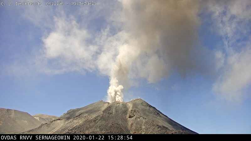
Special volcanic activity report (REAV), region of the Nevados de Chillán volcanic complex, on January 22, 2020 at 03 h 48, local time (mainland Chile).
The National Geological and Mining Service of Chile (Sernageomin) discloses the following PRELIMINARY information, obtained using surveillance equipment from the National Volcanic Surveillance Network (RNVV), processed and analyzed at the South Andes Volcanological Observatory (OVDAS ):
On Wednesday January 22, 2020 at 3:22 a.m. local time (6:22 a.m. UTC), the monitoring stations installed near the Nevados de Chillán volcanic complex recorded an earthquake associated with rock fracturing.
The characteristics of the LP earthquake are as follows:
TIME OF ORIGIN: 3:22 a.m. local time (6:22 a.m. UTC).
LATITUDE: 36 880 ° S
LONGITUDE: 71.347 ° W
DEPTH: 3.9 km
LOCAL MAGNITUDE: 3.3 (ML)
OBSERVATIONS:
Following the occurrence of the higher energy earthquake, two events, an earthquake type VT (ML = 1.4) and an earthquake type LP (reduced displacement = 7 cm2) were recorded. This process induced the presence of particulate materials on the surface and a low altitude glow.
The volcanic technical alert is maintained at the ORANGE level.
Source : Sernageomin .
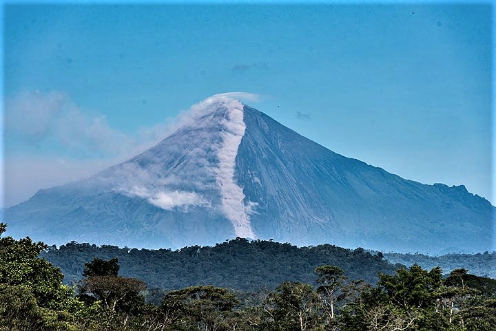
Ecuador , Sangay :
DAILY REPORT OF THE STATE OF SANGAY VOLCANO, Wednesday January 22, 2020.
Information Geophysical Institute – EPN.
Surface activity level: High, Surface trend: No change.
Internal activity level: High, Internal trend: No change.
Seismicity (events): From January 21, 2020, 11:00 a.m. to January 22, 2020, 11:00 a.m :
Long Period Type (LP): 115 events
Explosions (EXP): 31 events
Emission limits: (TE): 7.
Gas (SO2): 534.0 +/- 273.0 tonnes / Day.
Rains / lahars: No rains recorded. ** Following the constant rains in the volcano sector, the accumulated volcanic material can re-mobilize and generate muds and debris flows (secondary lahars) which can reach the Volcan and Upano rivers.
Emission / ash column: In the morning, the volcano cleared and it was possible to observe a continuous emission of vapors, gases and ash, at a maximum altitude of 700 m above the crater, with a North and Northeast direction .
Other monitoring parameters: no change.
Observations: In the day today, the weather was clear, it was possible to observe the descent of blocks on the Southeast flank. The volcano is currently cloudy.
Alert level: yellow
Source : IGEPN.
Photo : Volcanodiscovery.
Mexico , Popocatepetl :
January 22, 11:00 a.m. (January 22, 5:00 p.m. GMT).
According to the Popocatepetl volcano monitoring systems, 96 exhalations and 170 minutes of tremors were identified. Due to cloudy conditions during certain events, it was not possible to confirm whether they were accompanied by an ash emission. In addition, two volcano-tectonic earthquakes were recorded yesterday at 6:35 p.m. and 8:04 p.m., with an estimated magnitude of 1.3 and 1.7, respectively.
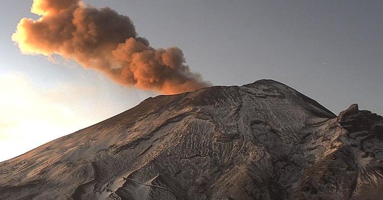
At the time of this report, the volcano is observed with an emission of volcanic gases and a slight amount of ash with a height of 200 m above the crater, in an eastern direction.
CENAPRED urges NOT to APPROACH the volcano and especially the crater, because of the danger of falling ballistic fragments, and in case of heavy rain stay away from the bottom of the ravines because of the danger of mudslides and debris.
The Popocatépetl volcanic signaling light is in YELLOW PHASE 2.
Source : Cenapred .