Décember 16 , 2019.
Indonesia , Dukono :
VOLCANO OBSERVATORY NOTICE FOR AVIATION – VONA.
Issued: December 15 , 2019 .
Volcano: Dukono (268010)
Current Aviation Colour Code: ORANGE
Previous Aviation Colour Code: orange
Source: Dukono Volcano Observatory
Notice Number: 2019DUK108
Volcano Location: N 01 deg 41 min 35 sec E 127 deg 53 min 38 sec
Area: North Maluku, Indonesia
Summit Elevation: 3933 FT (1229 M)
https://www.facebook.com/claudio.jung.1/videos/10220496598026778/
Volcanic Activity Summary:
Eruption with volcanic ash cloud at 23h56 UTC (08h56 local).
Volcanic Cloud Height:
Best estimate of ash-cloud top is around 6493 FT (2029 M) above sea level, may be higher than what can be observed clearly. Source of height data: ground observer.
Other Volcanic Cloud Information:
Ash-cloud moving to south
Remarks:
Eruption and ash emission is continuing.
Level of activity at level II (WASPADA). G. Dukono (1 229 m above sea level) experiences a continuous eruption. The last eruption occurred on November 24, 2019, resulting in an eruption column height of 500 m. The color of the gray column was observed to be white / gray.
The volcano is clearly visible until it is covered with fog. The smoke from the crater is observed white / gray in color with a strong, thick intensity, about 200 to 800 meters above the summit. The weather is sunny to cloudy, the winds are weak to moderate towards the South and the Southwest. Air temperature around 25-32 ° C. Humidity 75-83%.
According to the seismographs of December 15, 2019, it was recorded:
2 earthquakes felt
3 distant tectonic earthquakes.
Continuous tremor, amplitude 0.5-14 mm (dominant value of 1 mm)
Recommendation:
(1) The community around G. Dukono and visitors / tourists must not move, climb and approach the Malupang Warirang crater within a radius of 2 km.
(2) Since volcanic ash eruptions occur periodically and the ash dispersion follows the direction and speed of the wind, it is recommended that the community around G. Dukono always obtain masks / nose pads and mouth to use when necessary, to avoid the threat of volcanic ash in the respiratory system.
VONA:
The last VONA received the color code ORANGE, published on December 15, 2019 at 8:56 a.m., linked to an eruption with a height of the eruption column of approximately 800 m from the top of the peak or 2029 meters above from sea level. The eruption column is moving south.
Source : Magma Indonésie , PVMBG.
Photo et vidéo : Claudio Jung .
New Zealand , White Island :
Volcanic Alert BulletinWI – 2019/24 . Mon Dec 16 2019 1:30 PM; White Island Volcano
Volcanic Alert Level remains at 2
Aviation Colour Code remains at Orange
The level of volcanic tremor has remained low over the weekend and this morning (16 December) at Whakaari/White Island. No eruptions have occurred since Monday 9 December and further eruptions are unlikely in the next 24 hours. The Volcanic Alert Level remains at Level 2.
Since the eruption on Monday, December 9th, there has been no further significant eruptive activity and the level of volcanic tremor remains low.
The expert judgement made this morning calculated the likelihood of another eruption within the next 24 hours at 30 – 40%. This decrease in likelihood means another eruption is unlikely over the next 24 hours. Following this likelihood reduction, the distances for GNS Science staff access zones have reduced in line with this.
Aerial observations on Saturday and Sunday (14 and 15 December) have provided additional information about the active vent area. There are three main vents within a 100-metre square area. One is producing transparent high temperature gas, indicative of a shallow magma source that is within a few tens of metres below the surface. This open hot vent is responsible for the glow seen in night time images.
An explosive eruption can still occur with no precursory activity from this vent especially if there is a collapse of unstable material around the vent, or if the gas emission decreases allowing groundwater to enter the vent.
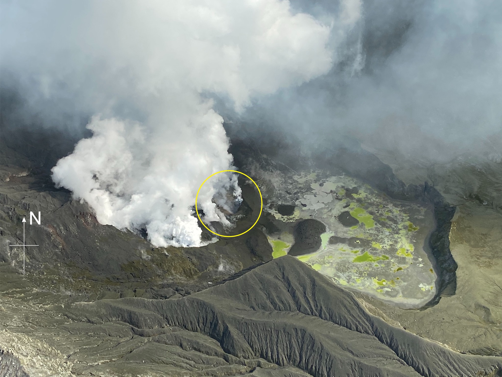
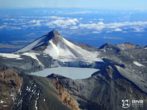
White Island crater area showing the active vent (circled).
We can see at least one active vent with a high rate of gas coming out of it (circled) temperatures of the gas are hot (at least 200 °C), and the blue tinge indicates that it is dominated by sulphur dioxide (SO2), which comes directly from the shallow magma (magma is molten rock). To us, it looks like a typical open vent volcanic system with magma not too far below the surface, possibly as shallow as a few 10s of metres beneath the surface. The other feature that shows very clearly is the former Crater Lake basin, a depression that was formed by eruptions between 1978 and 1990. Before Monday’s eruption, this basin was partially filled by a hot, acidic lake that was about 16 metres below over flow. Now much of the basin is infilled with debris with numerous, isolated ponds. Much of the ponded water is from recent rainfall that has been reacting with the eruption deposits.
The other vents are also producing large amounts of steam and gas and sudden steam/gas eruptions from them are still possible.
As the wind shifts to become more northerly today, gas might be noticed in the Ōpōtiki to Whakatāne area, as occurred on many occasions during the 1976 to 2000 eruptive period. People may feel this gas as a slight irritant on skin or eyes. Should any explosive activity produce an ash cloud, the anticipated impact on the mainland is very low. If ash did reach the mainland it would be more of a nuisance or disruption and not life threatening.
A 133 km deep earthquake last night in Bay of Plenty, although widely felt, did not cause any change in activity at the volcano.
Some monitoring equipment is partially buried under ash and the batteries at one site have gone flat. This has affected one of our three cameras. We still receive data from the remaining equipment, which allows us to continue monitoring the volcano. Both seismic stations on the island are fully operational and are providing us with round the clock data.
We will continue to provide daily updates on activity unless the situation changes.
GNS Science and our National Geohazards Monitoring Centre continue to closely monitor Whakaari/White Island for further signs of activity.
Source : Geonet / Craig Miller / Duty Volcanologist.
Photos : Geonet .
Vidéo : Timsvideochannel1.
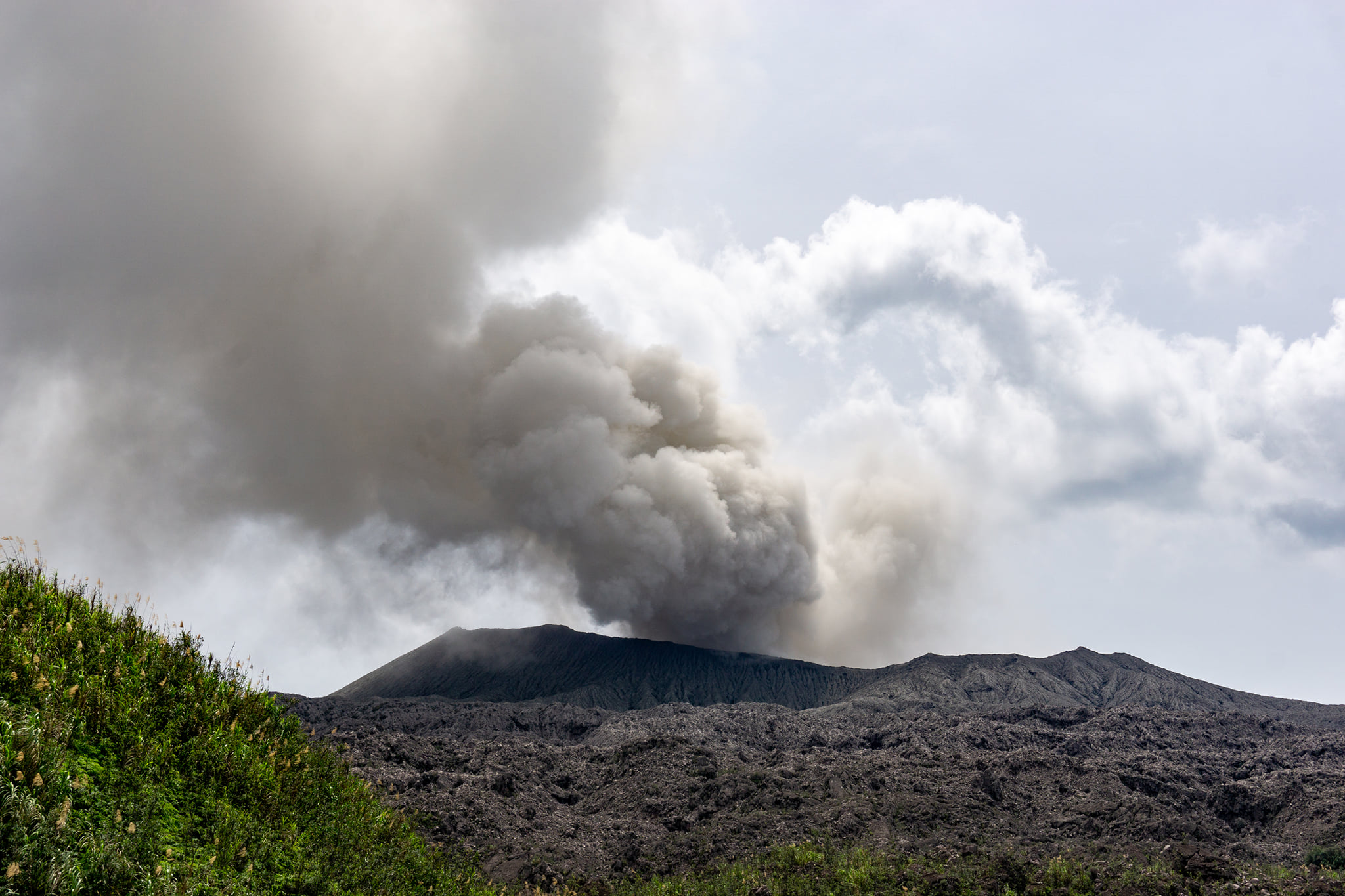
Kamchatka , Ebeko :
VOLCANO OBSERVATORY NOTICE FOR AVIATION (VONA).
Issued: December 15 , 2019 .
Volcano: Ebeko (CAVW #290380)
Current aviation colour code: ORANGE
Previous aviation colour code: orange
Source: KVERT
Notice Number: 2019-180
Volcano Location: N 50 deg 41 min E 156 deg 0 min
Area: Northern Kuriles, Russia
Summit Elevation: 3791.68 ft (1156 m)
Volcanic Activity Summary:
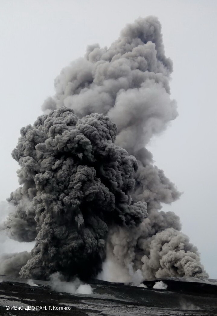
A moderate eruptive activity of the volcano continues. According to visual data by volcanologists from Severo-Kurilsk, explosion sent ash up to 3 km a.s.l., an ash cloud is drifting to the north-east from the volcano.
A moderate eruptive activity of the volcano continues. Ash explosions up to 19,700 ft (6 km) a.s.l. could occur at any time. Ongoing activity could affect low-flying aircraft and airport of Severo-Kurilsk.
Volcanic cloud height:
8856-9840 ft (2700-3000 m) AMSL Time and method of ash plume/cloud height determination: 20191215/0138Z – Visual data
Other volcanic cloud information:
Distance of ash plume/cloud of the volcano: 3 mi (5 km)
Direction of drift of ash plume/cloud of the volcano: NE
Time and method of ash plume/cloud determination: 20191215/0138Z – Visual data
Source : KVERT
Photo : T. Kotenko, IVS FEB RAS , 15/4/2017 .
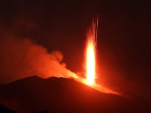
Guatemala , Pacaya :
Type of activity: Strombolian.
Morphology: Composite stratovolcano
Location: 14 ° 22’50’ Latitude N; 90 ° 36’00˝ Longitude W
Height: 2552msnm
Atmospheric conditions: partly cloudy
Wind: North
Precipitation: 0.0 mm.
Activity:
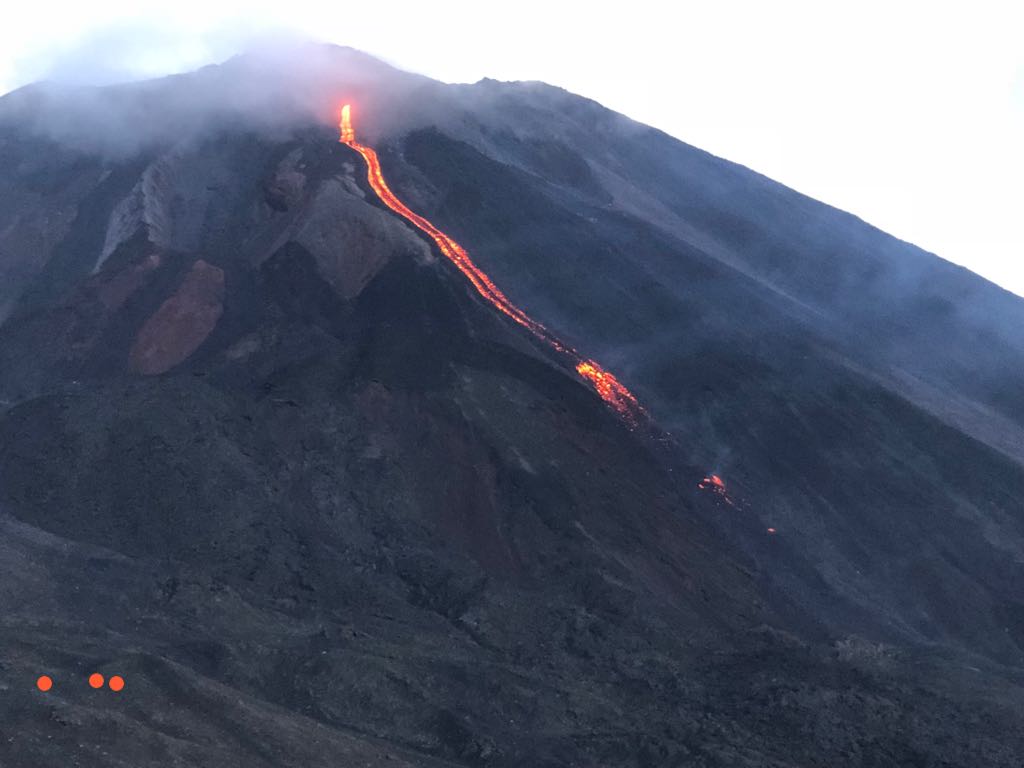
Presence of a weak degassing of blue and white coloring reaching a height of 200 meters above the cone, dispersing in a south-west direction, which moves over a distance of about 400 meters. Two active centers expel materials at heights between 10, 25 and 75 meters. Small explosions can be heard over distances of up to 3 km towards El Patrocinio. Lava flows migrate from the crater of the Mackenney cone over a length of approximately 150 meters, generating avalanches in front of the flows raising gray incandescent materials. Seismic stations record tremors associated with the rise of magma and the presence of gas, as well as occasional explosions.
Source : Insivumeh.
Photo : tn8.tv