December 11 , 2019.
New Zealand , White Island :
The eruption of the Whakaari volcano (White Island, New Zealand) on December 9, 2019, by Tullio Ricci and Dmitri Rouwet.
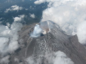
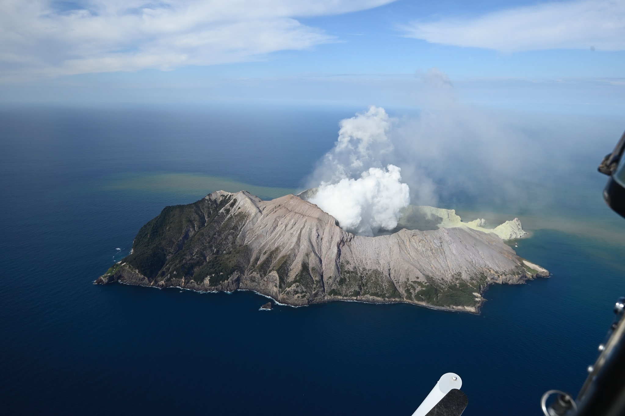
At 14:11 local time (UTC + 13) on December 9, 2019, an eruption occurred on the island of White Island, New Zealand, near the crater lake (one of the most acidic in the world) located in the Northwest Zone of Whakaari Volcano (Figures 1 and 2).
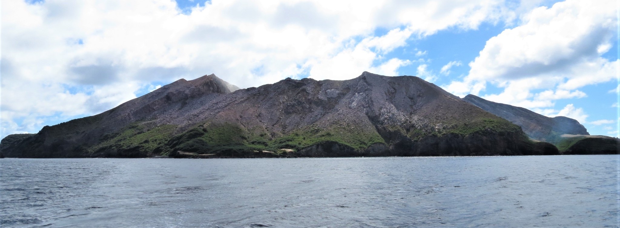
Figure 1 – White Island Island, New Zealand, from the Southwest (photo D.Rouwet, March 25, 2019).
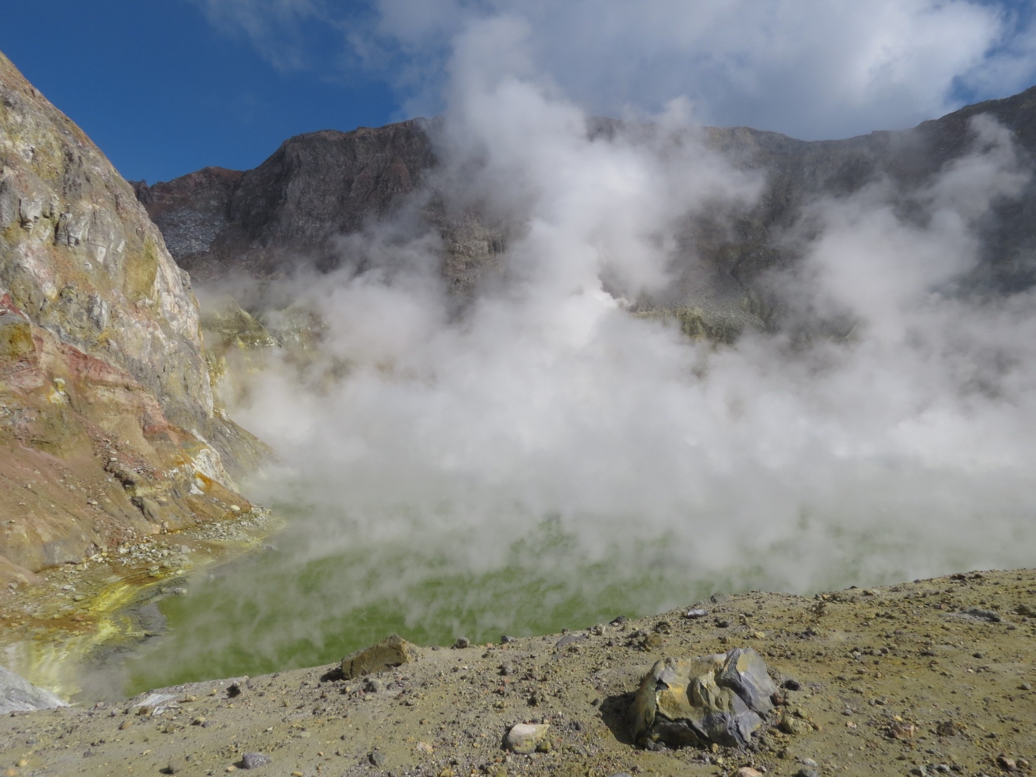
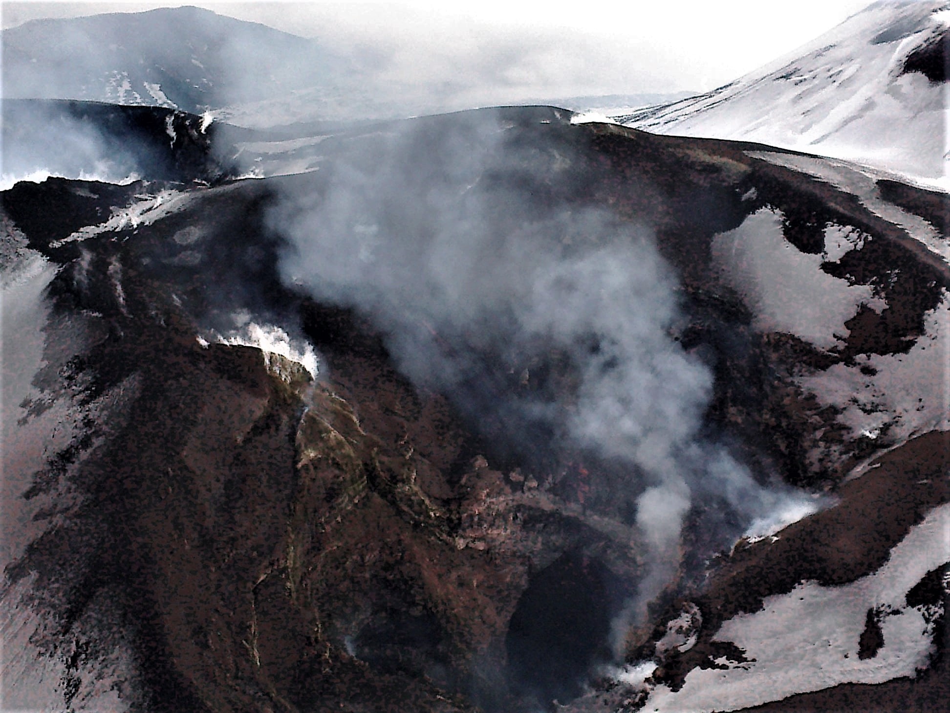
Figure 2 – The crater lake of Whakaari volcano, in the northwestern part of White Island, NZ, taken from the south (photo D.Rouwet, March 25, 2019)
At 8:30 pm (Italian time) on December 9, the death toll was 5 dead, 18 wounded (mostly burned) hospitalized in nearby hospitals and 28 missing. Rescue operations have been suspended due to the dangerous conditions of the volcano and at night, but police say there are no survivors on the island of overflights after the eruption. One of the victims was an experienced guide from a local tour operator.
It was a sudden and brief eruptive event that affected the crater area of the volcano (about 800 x 500 m) which is among the most active in New Zealand (source: https://www.geonet.org .nz / ). White Island is privately owned and is a popular tourist destination, visited annually by approximately 10,000 people.
Judging by the images available on the Web, this could be an essentially phreatic explosion, characterized by basal pyroclastic surges. Ground explosions are generally the least predictable type of explosion in a volcano’s activity.
;
Guardian News Channel Youtube Videos
The video shows the White Island eruption of 9 December 2019 taken from the sea on the east side of the island (00: 00-00: 20), the basal pyroclastic surges taken from the sea on the south side of the island ( 00: 20- 00:25), the time-lapse eruption from the GNS surveillance camera located at Wakatane on the Bay of Plenty (00: 25-00: 41), the eruption turned into time-lapse with the crater and crater lake taken from the GNS surveillance camera located on the eastern edge of the crater (00: 41-00: 54), mooring tourist boats located south of the island and taken back from the sea with the first aid provided by boats for the Guided Tours of the region (00: 54-01: 03), video of the crater lake probably shot about 30 minutes before the eruption (01: 03- 01:14), the helicopter damaged by the eruption inside the crater and a view from the sea near the mooring of the tourist boats (1:15) -01: 26), confere press release of the New Zealand Prime Minister (01: 26-01: 48).
Immediately after the eruption, the level of volcanic alert was raised to level 4 of 5 (moderate ongoing eruption with danger located around the island) by the GNS Science (Institute of Geological and Nuclear Sciences), to be next lowered to 3 (minor rash underway with danger located near the mouths), about two hours after the eruptive event.
The eruption generated a column of ash that exceeded 3500 m altitude, while the ashes covered the entire crater area and the immediate surroundings. The GNS Science does not expect a relapse of ashes, if not minimal, on the North-East coasts of the North Island, about 50 km away.
The surveillance networks of the New Zealand entities GNS Science and National Geohazards Monitoring Center have detected a decrease in volcanic activity since the end of the eruption, but there remains a high degree of uncertainty about the possibility of new eruptive events.
White Island, located in Plenty Bay and also known as the Maori name of Whakaari, is New Zealand’s largest volcano in terms of volume. The island, about 2 x 2.6 km, represents only 30%, reaching a maximum height of 321 m above sea level. It is a stratovolcano active for about 150,000 years, which marks the northern boundary of the Taupo Volcanic Zone (TVZ) and includes several active volcanoes of the North Island, including some geothermal sites. Among the most famous volcanoes are: Ruapehu, Ngauruhoe, Tongariro, Tarawera and the Taupo caldera.
The activity is characterized by continuous hydrothermal activity (Figure 3) and small eruptions. The last eruption with victims dates back to 1914, when 12 miners on the island lost their lives due to activities related to sulfur extraction.
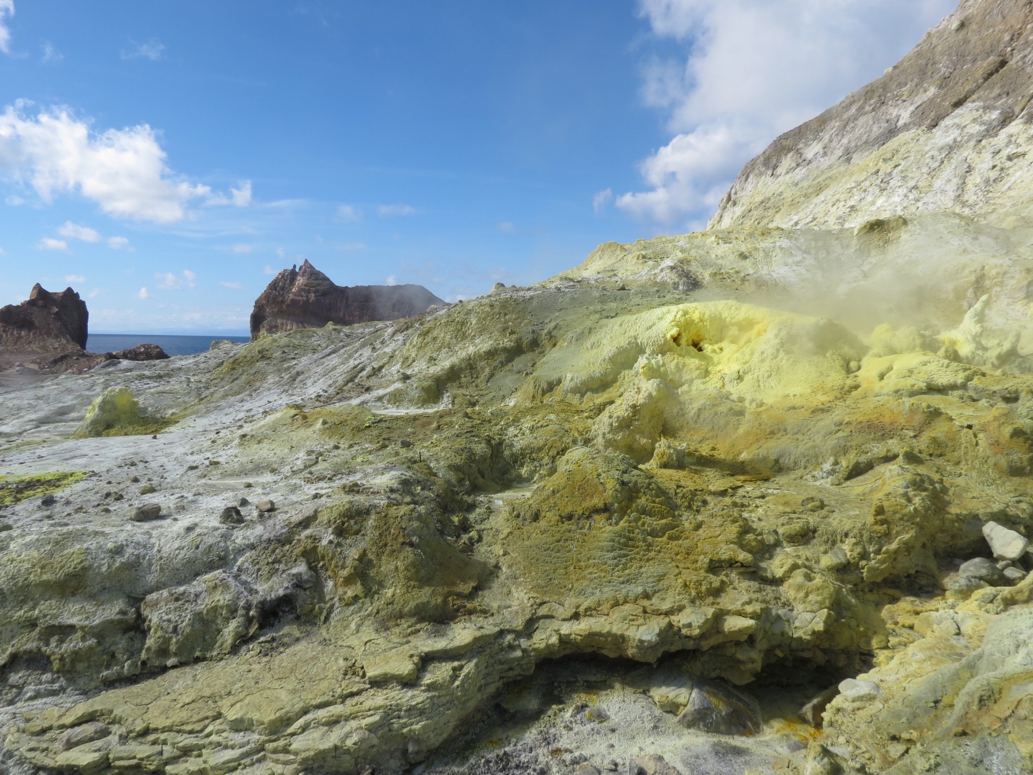
Figure 3 – White Island, NZ. Crater smoke located on the south side of the crater; the field of vision frames the south-east sector of the island (photo D. Rouwet, March 25, 2019).
On November 15, 2019, the level of volcanic activity was raised to level 2 (moderate volcanic disturbance) due to the occurrence of hydrothermal explosions (geyser-type steam explosions) with projected mud and debris. 30 m above the vents. More recently, at 16:34 UTC November 23, the volcano was rocked by a deep earthquake (115 km) of M 6.0, with its epicenter located 6.2 km northeast of the island (source: INGV ).
Previously, the last ash emissions were observed in April and September 2016 and the level of volcanic activity, in both cases, had gone from 1 (minor volcanic disorders) to 3 (minor eruption in progress) (source: https: //volcano.si.edu/).
Other eruptive episodes occurred in 2012 and 2001 while between 1975 and 2001 there were small frequent eruptions with the emission of ash, steam and gas clouds that reached 10 km in height. , accompanied in some cases by incandescence linked to the eruptive activity visible from the coast of Plenty Bay.
Volcanic Alert BulletinWI – 2019/17 . Wed Dec 11 2019 5:30 PM; White Island Volcano
Volcanic Alert Level remains at 3
Aviation Colour Code remains at Orange
The level of volcanic tremor continues to rise and there is medium likelihood of future eruptive activity in the next 24 hours. The Volcanic Alert Level remains at Level 3.
Since our morning bulletin the level of volcanic tremor has continued to rise and is now at the highest level seen since the 2016 eruption.
Our interpretation of all our monitoring data to date, including yesterday’s gas flight is that shallow magma within the volcano is driving the tremor, gas flux, and jetting activity observed in the craters created during the eruption.
Earlier today we conducted an expert judgement and the result is that there is a medium likelihood (40-60% chance) of a future eruption within the next 24 hours.
There is an extremely low likelihood of any potential ash affecting the mainland, but people may smell gas, depending on the prevailing wind direction.
Our monitoring equipment continues to function and is providing us with continuous data on the volcano’s activity.
GNS Science and our National Geohazards Monitoring Centre continue to closely monitor Whakaari/White Island for further signs of activity. Volcanic Alert Level 3 indicates a minor local eruption is in progress.
Source : INGV Vulcani . Geonet / Craig Miller / Duty Volcanologist .
Photos : D.Rouwet ,The Next California Earthquake.
Italy / Sicily , Etna :
Weekly bulletin from 02December 2019 to 08 December 2019 (issue date 10/12/2019)
SUMMARY OF THE ACTIVITY.
In light of the surveillance data, we highlight:
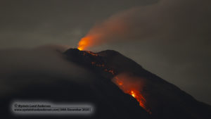
1) VOLCANOLOGICAL OBSERVATIONS: Strombolian activity of the New Southeast Crater. Strombolian intra-crater activity with sporadic ash emissions from the Northeast crater and craters of Voragine and Bocca Nuova.
2) SISMOLOGY: Modest seismic activity due to fracturing; the average amplitude of volcanic tremor showed a clear variation that started on December 6 and ended in the early hours of December 7, which brought the amplitude values to « high » values.
3) INFRASONS: A moderate infrasonic activity has been recorded.
4) DEFORMATIONS: The inclination and GPS networks did not show any significant changes in previously reported trends.
5) GEOCHEMISTRY: SO2 fluxes are of average level. Ground CO2 flows are at medium values, following a moderate upward trend. The partial pressure of CO2 in the soil does not show any significant changes. Helium isotopic ratio values are at medium-high values (latest data available November 21).
VOLCANOLOGICAL OBSERVATIONS.
The monitoring of volcanic activity in the summit craters of Etna, during the week, was carried out by analyzing the images of the surveillance network of the INGV Catania section, Osservatorio Etneo (INGV-OE) and thanks to remote observations made by INGV field staff. Adverse weather conditions made observations periodically difficult, especially in the early part of the week. As in previous weeks, the Etna activity was characterized by an eruptive intra-crater activity of the summit craters (Northeast crater – NEC, Voragine-VOR crater and Bocca Nuova crater – BN). . As of December 6, an increase in Strombolian activity was observed for the New Southeast Crater (NSEC).
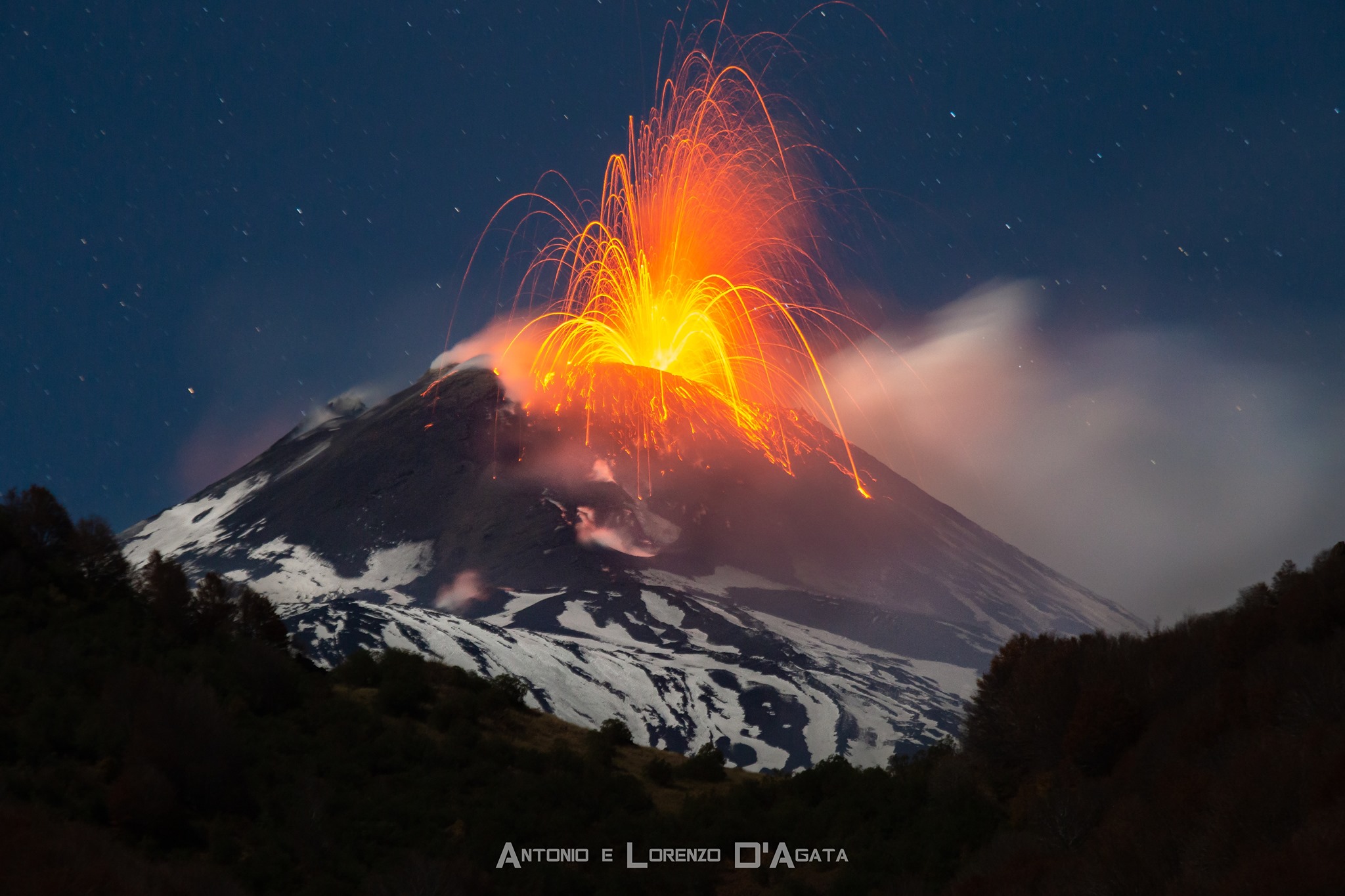
In particular, after the sporadic ash emissions observed at the end of last week (25 November – 1 December) and the only explosion reported in the evening of 1 December (No. 49/2019), Strombolian activity at the New Crater Southeast (NCSE) has seen a dramatic increase. After a few isolated explosions in the morning of December 6, from approximately 18:00 UTC, CCTV cameras show a gradual intensification of Strombolian activity, which produces frequent explosions and spills of incandescent materials along the slope. of the cone. This activity continued almost continuously during the rest of the observation period and was clearly visible also in the countries of Etna and Catania.
Strombolian intra-crater activity in the Northeast Crater (NEC) was characterized by some continuity throughout the week, but with significant fluctuations in the intensity of the explosions. However, the emission of incandescent products from the edges of the crater has never been observed and the explosions have produced only glints that reflect on the plume of gas above the crater. Strombolian intra-crater activity of the craters of Voragine (VOR) and Bocca Nuova (BN) continued under the same conditions as those already described in previous weeks. While in most cases the explosions generated only glows that are reflected in the gas plume that dominates the craters, in some cases the glowing pyroclastic materials have exceeded the height of the crater rim. Finally, on the morning of December 6, a lava flow is observed, which, coming from the base of the slag cone inside the Voragine, flows into the adjacent Bocca Nuova, a phenomenon that had already been observed in the 18-19 September.
Volcanic tremor:
During the week in question, the average amplitude of volcanic tremor showed a clear variation that began on December 6 and ended in the early hours of December 7, which brought the amplitude values to levels « high ». In the following days, the amplitude of the tremor remained at high levels, showing only slight fluctuations. The location of the center of gravity of the tremor springs, as well as the increase in amplitude, moved in a southeasterly direction and in the following days it remained below the New Southeast Crater between 2750 and 3000 m above mean sea level.
Source : INGV Vulcani.
Read the full article : file:///C:/Users/Utilisateur/AppData/Local/Packages/Microsoft.MicrosoftEdge_8wekyb3d8bbwe/TempState/Downloads/BollettinoEtna20191210%20(7).pdf
Photos : Antonio e Lorenzo D’Agata via Sherine France , Hélicoptère de Piero Berti (aka Joseph Nasi), Butterfly Helicopters .
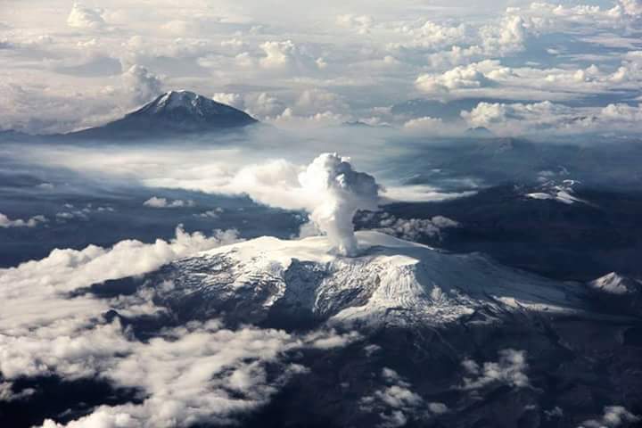
Colombia , Nevado del Ruiz :
Nevado del Ruiz Volcano Activity Bulletin
The level of activity continues at: yellow activity level or (III): changes in the behavior of volcanic activity.
Regarding the monitoring of the activity of the Nevado del Ruiz volcano, the COLOMBIAN GEOLOGICAL SERVICE reports that:
The Nevado del Ruiz volcano continues to show unstable behavior. During the past week, some of the monitored parameters continued to show changes, reflecting instability of the volcanic system similar to those reported in recent weeks. The variations are mainly distinguished in seismicity, both associated with the movement of fluids within the volcanic ducts and with the fracturing of the rocks and with the surface activity of the volcano. It is not excluded that the monitored parameters continue to change, indicating an acceleration of the process and consequently changes in the activity level of the volcano.
Seismicity related to fluid dynamics within the volcanic vents, continued to show a decrease in the number and a slight increase in recorded earthquake energy compared to the previous week. This type of seismicity showed significant variations in spectral characteristics and was characterized by the presence of continuous volcanic tremors and long-period (LP) and very long-lived (VLP) earthquakes recorded individually or in conjunction with volcanic tremor. The earthquakes showed varying energy levels and were mainly located in the Arenas crater and its surroundings.
Some of these signals were associated with small gas and ash emissions, which were confirmed by cameras installed in the volcano area and reports issued by VAAC (Current Volcanic Ash Advisories).
The seismicity caused by rock fracturing showed an increase in the number of earthquakes and a slight decrease in released seismic energy, compared to the previous week. This type of seismicity was mainly located in the Northeast, South, Southwest and Northwest sectors of the volcanic structure and, to a lesser extent, in the Arenas crater and its surroundings. The depth of the earthquakes ranged from 0.3 to 8.5 km. The maximum magnitude recorded during the week was 1.8 ML (local magnitude), corresponding to the earthquake recorded on December 3 at 08:16 (local time) located 3.6 km southwest of the Arenas crater and 3.7 km deep.
As part of the monitoring of the information provided on the MIROVA and NASA FIRMS web portals, low-energy thermal anomalies were recorded on 03, 09 and 10 December.
The Nevado del Ruiz volcano continues at the level of yellow activity.
Source : SGC.
Guatemala , Santiaguito :
Activity type: Pelean
Morphology: Complex of dacitic domes
Geographical location: 14 ° 44 ’33 ˝ Latitude N; 91 ° 34’13˝ Longitude O
Height: 2500msnm
Atmospheric conditions: Clear
Wind: East at 5 km / h.

Activity:
The Caliente dome has a white degassing fumarole at a height of 3000 meters above sea level (9842 feet) which is dispersed in a southwesterly and western direction. The seismic station STG3 records weak to moderate explosions expelling ash columns at an approximate height of 3200 and 3400 m (10498 and 11154 feet) which are dispersed to the southwest, fine ashes fall on the villages of Loma Linda and San Marcos Palajunoj. Constant avalanche activity is generated on the southwest and southeast flank of the dome, with some blocks reaching the lower part of the dome.
Source : Insivumeh.
Photo : Annie Winson , earthobservatory.sg