September 26 , 2019.
New Zealand , White Island :
Volcanic Alert Bulletin , Thu Sep 26 2019 9:30 AM.
Volcanic Alert Level remains at 1
Aviation Colour Code remains at Green
Small, muddy, geyser-like explosions are occurring in the active crater at Whakaari/White Island due to a rising crater lake drowning the active vents. This geysering poses no risk to visitors. The Volcanic Alert Level remains at Level 1.
Over the last three weeks, we have observed small-scale geyser-like explosions of mud and steam in the active vent area. These have reached a maximum height of about 10 metres. They do not pose any hazard to visitors to the island and are not a sign of increasing volcanic activity.
The crater lake level has been rising since early-August. The rising lake level has impacted the surface activity around the active vents on the west side of the crater floor. Geysering-type activity has become established in the main active vent due to hot steam and gas passing through the now drowned active vent area.
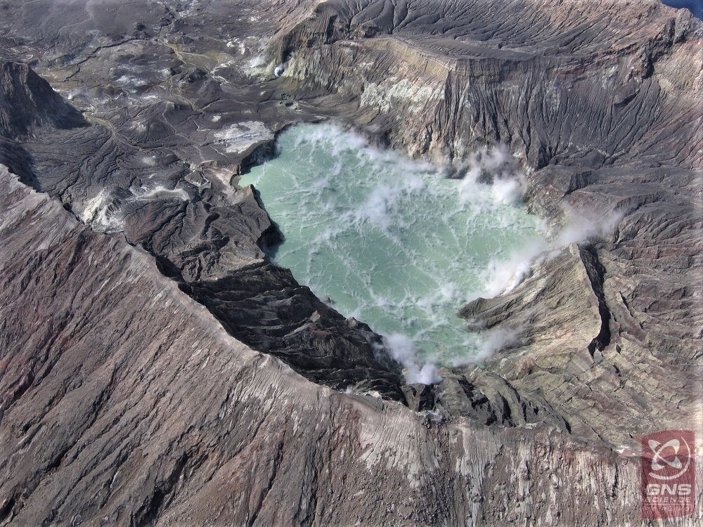
This geysering activity is not a sign of increasing volcanic activity. Normally the gas and steam would vent directly to the atmosphere, now it’s through the water in the vents and is visible as the geyser-like activity.
Monitored parameters at Whakaari/White Island include earthquake activity, volcanic tremor, gas flux, acoustic signals and visual images from the web cameras. These are complimented by regular soil gas surveys, sampling of springs and gas vents, ground deformation and magnetic surveys.
Recent measurements made on the island and the continuous data show no change in the monitored parameters outside of the expected signals for minor volcanic unrest.
As such the Volcanic Alert Level remains at Level 1. There is no change in the Aviation Colour Code: Green.
GNS Science and the National Geohazards Monitoring Centre continues to closely monitor Whakaari/White Island for further signs of activity.
Source : Steve Sherburn / Duty Volcanologist
Read the article : https://www.geonet.org.nz/vabs/3FCJSTo3bp9C4fXNF1iVaa
Photo : GNS science.
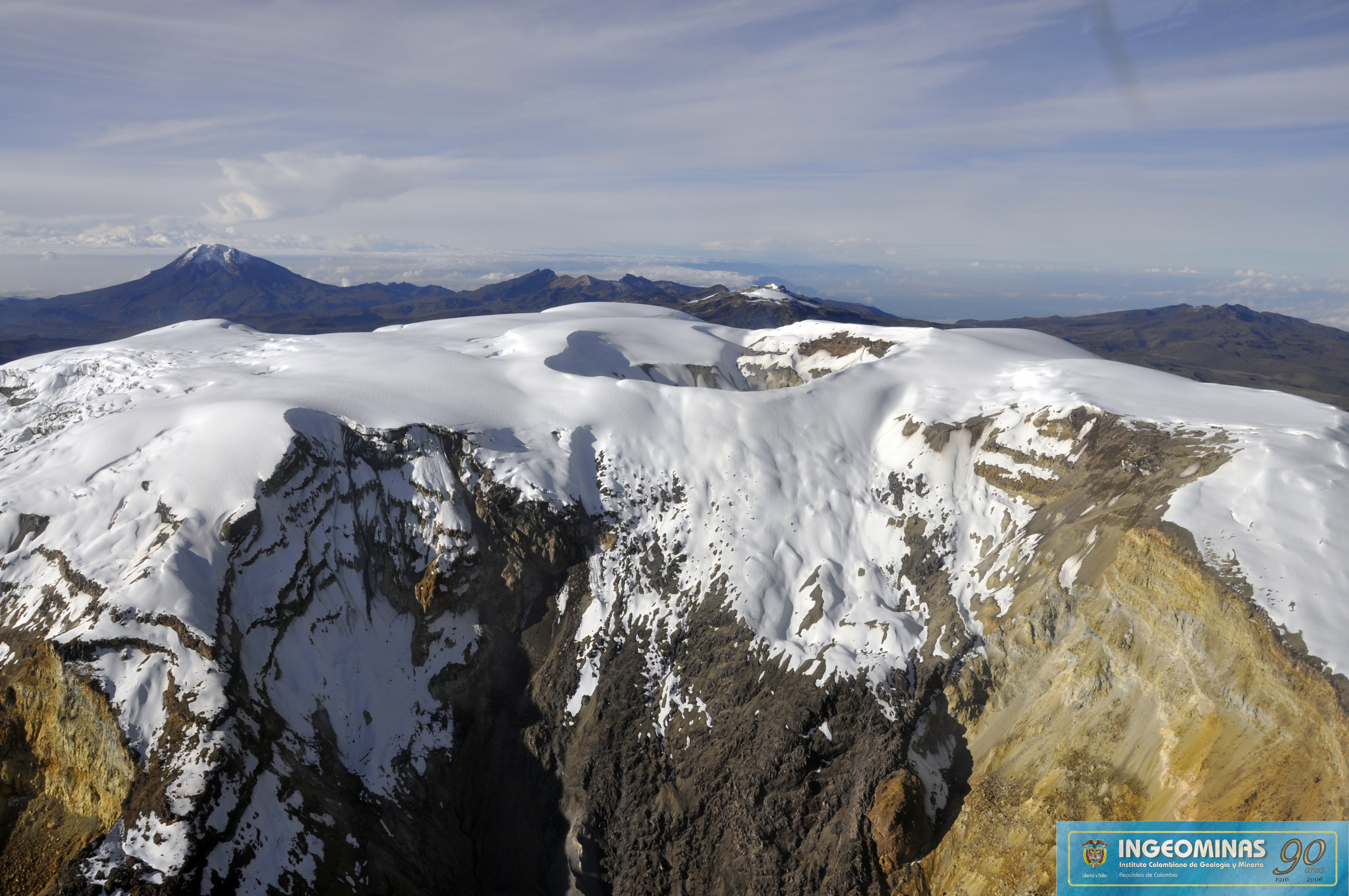
Colombia , Nevado del Ruiz :
Nevado del Ruiz Volcano Weekly Bulletin .
The level of activity continues at the level: Yellow activity level or (III): changes in the behavior of volcanic activity.
With regard to monitoring the activity of the Nevado del Ruiz volcano, the COLOMBIAN GEOLOGICAL SERVICE reports that:
The Nevado del Ruiz volcano over the past week continued to show instability in its behavior. The seismicity caused by rock fracturing resulted in an increase in the number of earthquakes and released seismic energy compared to the previous week. A slight seismic increase recorded on September 17th is highlighted. The earthquakes that occurred during this increase were located approximately 3.2 km northeast of the Arenas crater at depths between 3.0 and 6.0 km. Other active sources were the western and southwestern areas of the Arenas crater. The maximum magnitude recorded during the week corresponds to the earthquake of September 20th at 6:35 am (local time), a magnitude of 1.9 ML (local Magnitude), located in the crater Arenas, at a depth of 2.2 km .
The seismicity related to the dynamics of the fluids in the ducts of the volcanic structure showed an increase in the number of earthquakes and released seismic energy compared to the previous week. This seismic activity was characterized by the presence of earthquakes of long type and very long period. The earthquakes occurred mainly in the crater Arenas and its surroundings. Some of these signals were associated with small emissions of gas and ash.
Volcanic deformation measured from electronic inclinometers and Global Navigation Satellite System (GNSS) stations showed minor changes during the week.
The volcano continues to emit water vapor and gases into the atmosphere, among which is the sulfur dioxide (SO2), as evidenced by the values obtained by the SCANDOAS stations installed in the region of the volcano. satellite image analysis.
The column of gas and steam reached a maximum height of 1530 m, measured at the top of the volcano on September 20th. The direction of dispersion of the column was governed by the direction of the wind in the area, mainly to the northwest of the volcano.
The Nevado del Ruiz volcano continues at the level of yellow activity.
Source : SGC.
Photo : Ingeominas.
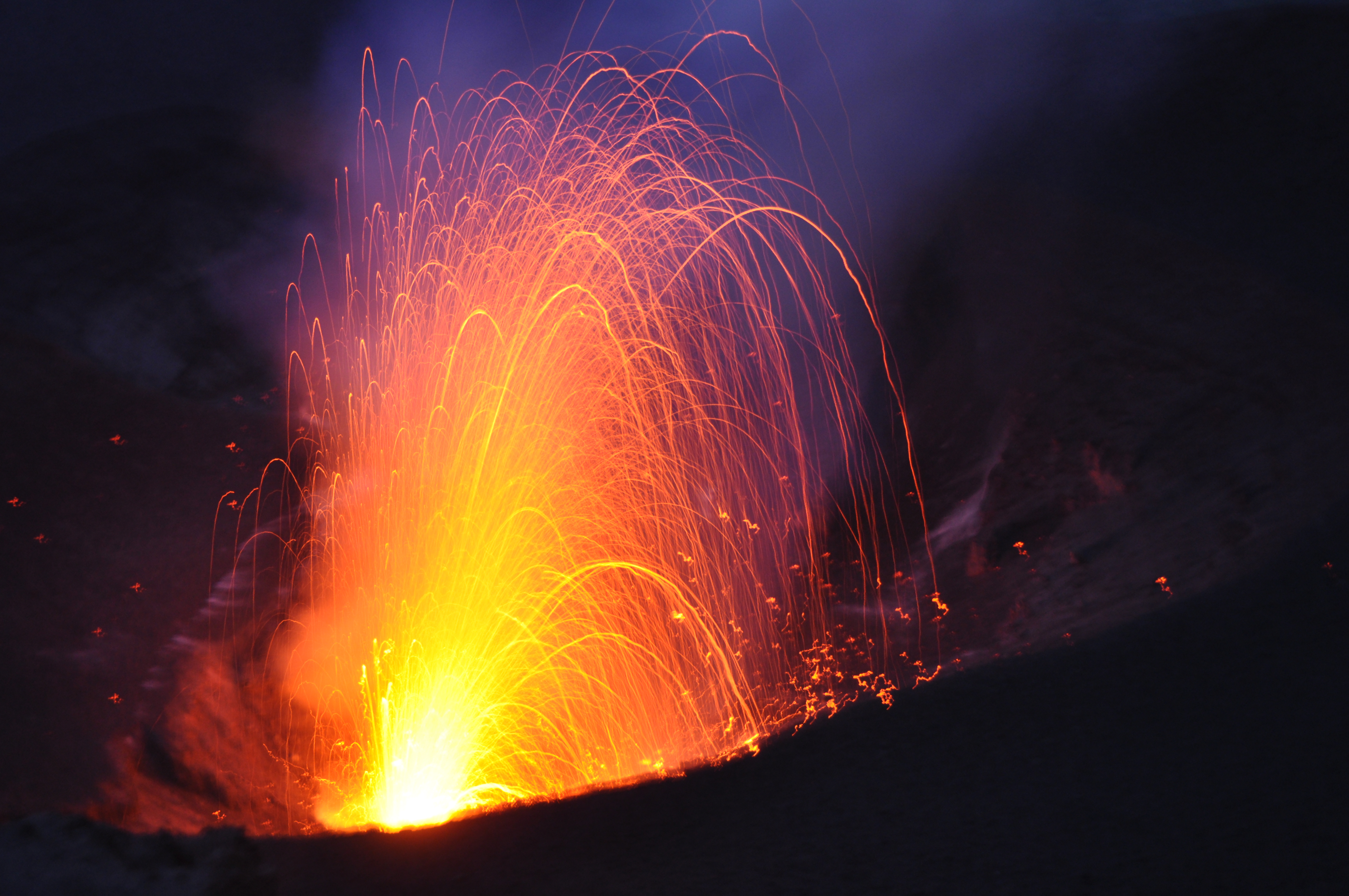
Guatemala , Pacaya :
14.382°N, 90.601°W
Elevation 2569 m
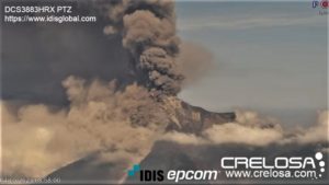
A special report from INSIVUMEH noted that seismic activity at Pacaya continued to increase, with RSAM values reaching 8,000 units by 18 September, coincident with an intensification of explosive activity at Mackenney Crater. Explosions from a growing cone in the crater ejected material as high as 100 m above the cone. Lava effusion increased; several lava flows (300-500 m long) advanced on the N and NW flank towards Cerro Chino and produced avalanches of blocks up to 1 m in diameter from the flow fronts. Strombolian explosions during 19-24 September ejected material 5-25 m above the cone, though on 21 September material was ejected as high has 100 m. Two lava flows traveled SW on 21 September.

The seismic activity continues with increases reaching 7,000 units according to the Real Time Seismic Record (RSAM), this is mainly due to the explosive activity that has increased during this week, to the increase of the internal tremor and finally to the migration of Lava flows to the North-North-West. As reported in daily OVPAC reports, the maximum outgassing during this week was 350 meters above the crater. This degassing is transported in different directions due to the variation of the recorded wind.
During this week, there were explosions classified as weak, they raised materials reaching 15 to 75 meters above the crater in formation and deposited them nearby, thus contributing to the growth of the cone intra- crateric.
The sound of the explosions spread over a greater distance, reaching 1 kilometer around the Mackenney cone.
Flows continue to grow from a side emission point up to 300 meters long this week.
A total accumulated precipitation of 15.2 millimeters was recorded during the week.
Sources : GVP , Insivumeh .
Photo : Nelo .
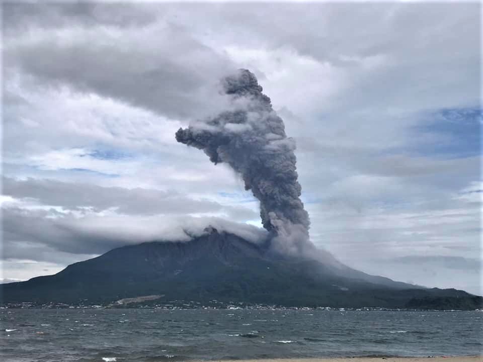
Japan , Sakurajima :
31.593°N, 130.657°E
Elevation 1117 m
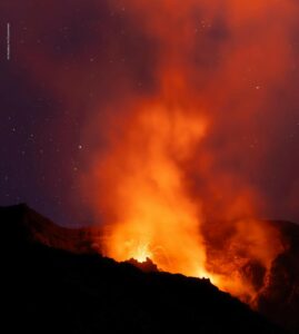
JMA reported that incandescence from Minamidake crater (at Aira Caldera’s Sakurajima volcano) was occasionally visible at night during 17-24 September. There were 30 eruptive events, 11 of which were explosive. Plumes rose as high as 2.6 km above the crater rim, and material was ejected as far as 1.7 km from the crater. On 20 September one of the explosions produced an ash plume that rose 3.4 km above the crater rim before merging into weather clouds. Large blocks were ejected 500-700 m. The Alert Level remained at 3 (on a 5-level scale).
The Aira caldera in the northern half of Kagoshima Bay contains the post-caldera Sakurajima volcano, one of Japan’s most active. Eruption of the voluminous Ito pyroclastic flow accompanied formation of the 17 x 23 km caldera about 22,000 years ago. The smaller Wakamiko caldera was formed during the early Holocene in the NE corner of the Aira caldera, along with several post-caldera cones. The construction of Sakurajima began about 13,000 years ago on the southern rim of Aira caldera and built an island that was finally joined to the Osumi Peninsula during the major explosive and effusive eruption of 1914. Activity at the Kitadake summit cone ended about 4850 years ago, after which eruptions took place at Minamidake. Frequent historical eruptions, recorded since the 8th century, have deposited ash on Kagoshima, one of Kyushu’s largest cities, located across Kagoshima Bay only 8 km from the summit. The largest historical eruption took place during 1471-76.
Sources : JMA, GVP.
Photo : Koki Arima .
Vanuatu , Yasur :
1
19°32’0”S 169°26’30”E
Summit : 1184ft (361m)
Current Volcano Alert Level: Level 2
Yasur volcano is continuing in the major unrest state. The Volcanic Alert Level remains at Level 2 .
The volcanic unrest continues at Yasur. The volcanic activity is likely to continue at similar level, consistent with Volcanic Alert Level 2. The danger zone remains at 395 m around the eruptive vents. The Danger Zone for life safety is limited in the Permanent Exclusion Zone .
Latest observations and analysis of seismic data recorded from the monitoring network confirm a continuous volcanic activity in the level of major unrest state and is confined in the crater. The activity consists of ongoing explosions. Some explosions remain strong and volcanic bombs may fall in and/or around the crater. Eruptive vents may emit volcanic gases and/or ash clouds. Gas will be continue to be smell while approaching the caldera and crater.
Source : Geohazard Vanuatu .
Photo : G Vitton.