August 19 , 2019.
Japan , Asama :
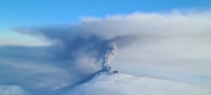
Volcanic alert lowered for Mt. Asama after eruption in early Aug.
The weather agency on Monday lowered the volcanic alert level for Mt. Asama in central Japan, saying volcanic activity is now not expected to intensify following a small eruption in early August.
The alert level on a 5-point scale was lowered to 2, which warns against approaching the crater, from 3, which advises not approaching the 2,568-meter-high volcano near the Karuizawa resort area northwest of Tokyo.
The Japan Meteorological Agency still warns of the likelihood of flying rocks and pyroclastic flows within about a 2-kilometer radius of the crater.
On Aug. 7, Mt. Asama experienced a small eruption and the agency raised the alert level from 1 to 3. There were no reports of casualties caused by the eruption but volcanic ash was found on the Gunma prefectural side of the mountain.
The agency said the eruption was highly likely to be a steam explosion, in which groundwater heated by lava turns into vapor and explodes without spewing magma.
It concluded that the possibility of an eruption affecting areas beyond the 2-km radius from the crater is low.
As of Monday, no crustal movement suggesting the rise of magma has been observed, it said, adding that there have not been many volcanic earthquakes and only a small amount of volcanic gas has been released.
If a small eruption occurs while showing signs of increasing volcanic activity including an expansion of the mountain shape, the alert level will be 3 as before. However, if there are no such signs, similar to the Aug. 7 eruption, the level will be 2.
Source : mainichi.jp
Photo : Nautiljon
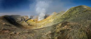
Italy , Stromboli :
The effusive activity resumed on Stromboli.
COMMUNICATION on the volcanic activity of August 18, 2019, 11:10:56 (UTC) – STROMBOLI.
The Osservatorio Etneo, from the National Institute of Geophysics and Volcanology, reported that by 1:00 UTC, effusive activity had resumed through an ephemeral mouth located in the south-central area of the crater terrace. The lava front is about 500 meters above sea level and the products emitted roll along the Sciara del Fuoco, accumulating along the coastline. Regarding the level of volcanic tremor, there is no significant change from what is indicated in the detailed statement of 16/08/2019 at 17:05.

PRESS RELEASE N ° 21 ACTIVITY STROMBOLI VOLCANO OF 11.30 AM (LOCAL TIME) OF 18.08.2019
Sunday, August 18, 2019
It should be noted that as of yesterday morning from 00:35 UTC, the thermal camera of Punta dei Corvi (Figure 1) shows the resumption of the effusive activity of a probably ephemeral vent at an altitude of about 550 to 600 m above sea level, below the area of the central crater.
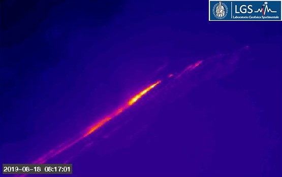
The MODIS image of this morning at 01:50 UTC recorded a high thermal anomaly (125 MW), compatible with this activity.
Currently, the flow is still well fed.
All monitored parameters remain on values between high and very high.
Source : INGV Vulcani , https://www.facebook.com/INGVvulcani-
LGS : http://lgs.geo.unifi.it/index.php/blog/comunicato-stromboli-18-agosto-h1130
Photo : Iacullo Antonio
Indonesia , Anak Krakatau :
VOLCANO OBSERVATORY NOTICE FOR AVIATION – VONA.
Issued: August 19 , 2019
Volcano: Anak Krakatau (262000)
Current Aviation Colour Code: ORANGE
Previous Aviation Colour Code: orange
Source: Anak Krakatau Volcano Observatory
Notice Number: 2019KRA147
Volcano Location: S 06 deg 06 min 07 sec E 105 deg 25 min 23 sec
Area: Lampung, Indonesia
Summit Elevation: 502 FT (157 M)
Volcanic Activity Summary:
Eruption with ash clouds at 02:09 UTC (09.09 local time).
Volcanic Cloud Height:
Ash-cloud is not visible
Other Volcanic Cloud Information:
Anak Krakatau is not clear
Remarks:
Eruption recorded on seismogram with maximum amplitude 46 mm and duration 60 second.
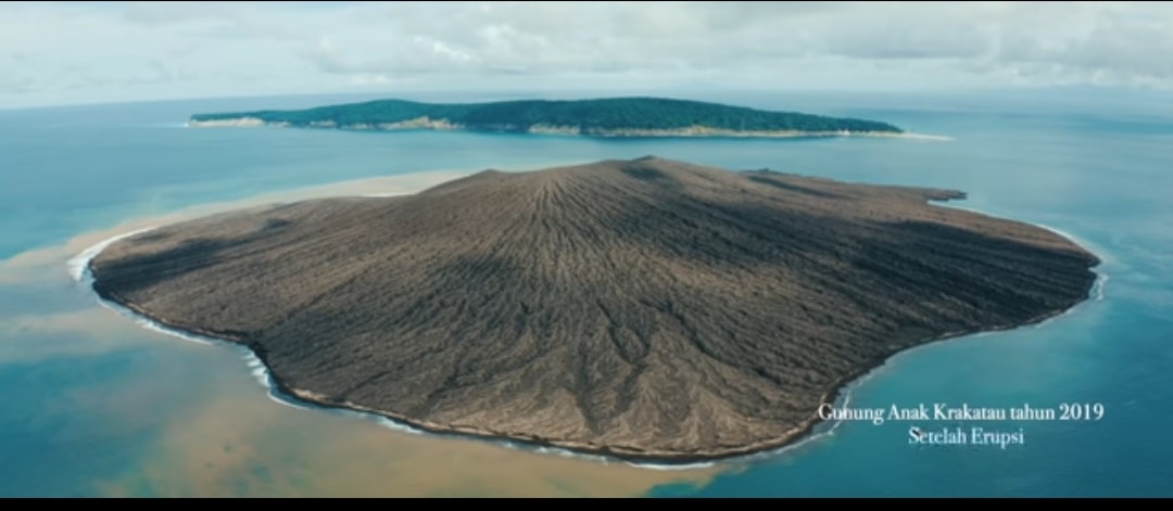
Level of activity at level II (Waspada), since March 25, 2019. G. Anak Krakatau (157 m altitude) has experienced an increase in its volcanic activity since June 18, 2018, which was followed by a series of eruptions from September 2018 to February 2019. In July 2019, eruptions still occur but their intensity decreases. Between yesterday and this morning, the volcano is covered by fog. The smoke from the crater is not observed.
The seismographs of August 18, 2019, recorded:
3 eruption earthquakes
A shallow volcanic earthquake.
Continuous tremor with a dominant amplitude of 5 mm
Recommendation: People / tourists are not allowed to approach the volcano within a radius of 2 km around the crater.
Sources : Magma Indonesia , PVMBG.
Photo : Ahmed Wahyu.
El Salvador , Santa Ana (Ilamatepec) :
Location: shared by the departments of Santa Ana and Sonsonate
Altitude: 2381 meters above sea level
Type of volcano: Stratovolcano
Activity type: Vulcanian – Strombolian
Last eruption: October 1, 2005.
The seismic vibration of the volcano remained between 14 and 20 RSAM units per day, that is to say in the normal range. In July, a total of 49 earthquakes related to fluid movements in the volcanic system were recorded. With regard to the earthquakes associated with the rupture of a solid support, nine were recorded and three were located, two on the north-west flank of the volcano crater and one on the south-east flank, at depths less than 2 km and magnitudes less than M 2.0. None were reported as felt by the inhabitants of the region.
With regard to sulfur dioxide (SO2) emissions, they fluctuated between 27 and 643 tonnes per day, with an average of 253 tonnes, values considered normal and close to the reference level (<300 tonnes / day); and typical of an open-duct volcanic system that exhibits constant degassing. According to the monitoring of the activity of the volcano, everything is normal.
Source : Marn .
Photo : globalgaz.
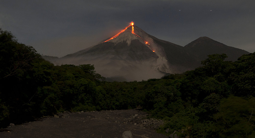
Guatemala , Fuego :
Type of activity: Vulcanian
Morphology: Composite Stratovolcano
Geographical location: 14 ° 28’54˝ Latitude N; 90 ° 52’54˝ longitude O
Height: 3,763msnm.
Weather conditions: partly cloudy
Wind: West at 5 km / h
Precipitation: 64.2 mm.
Activity:
Presence of white degassing fumaroles at an altitude of 4,300 meters above sea level that disperses to the west and southwest .11 to 18 low to moderate explosions per hour are generated which expel the columns of gray ash at a height of 4,500 to 4,700 meters (14765-15420). feet) scattered 12 to 20 km to the west and southwest. At night and in the early morning, incandescent impulses were observed at an altitude of 200 to 300 m with moderate to strong avalanches on the contour of the crater, heading towards the ravines Seca, Taniluya, Ceniza, Trinidad and Las Lajas. Low to moderate rumblings are perceived, which cause weak to moderate shock waves, causing vibrations of the roofs of houses of communities near the volcano. The noises are similar to those of train locomotives with time intervals of 3 to 8 minutes. Fine particles of ash fall in the areas of Panimaché I, Morelia, Santa Sofia, Porvenir, Palo Verde, Yepocapa and others.
Source : Insivumeh
Photo : Moises Castillo / Sputnik.