December 07 , 2018.
Chile , Copahue :
Special Report on Volcanic Activity (REAV), Bio-Bio Region, Copahue Volcano, 06 December 2018, 16:00 Local Time (Continental Chile).
The National Geological and Mining Service of Chile (Sernageomin) publishes the following PRELIMINARY information, obtained from monitoring equipment of the National Volcanic Monitoring Network (NVRN), processed and analyzed at the Volcanological Observatory of the Southern Andes (OVDAS) :
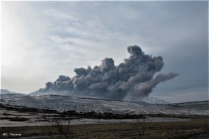
Yesterday, Thursday 06 December 2018, from 3:20 pm Local time, the monitoring stations installed near the Copahue volcano recorded a seismic swarm of 200 events associated with a process of fracturing rocks (Volcano-tectonic type), located at 6 , 2 km east-northeast of the active crater El Agrio.
The characteristics of the larger magnitude event, after its analysis, are as follows:
TIME OF ORIGIN: 15h56 Local time (18h56 UTC)
LATITUDE: 37.8197 ° S
LONGITUDE: 71.1073 ° W
DEPTH: 4.6 KM
LOCAL MAGNITUDE: 3.1 (ML)
OBSERVATIONS:
At the time of issuing this report, events of similar characteristics and magnitude were recorded. There is no information from the authorities or the population on their perception in the areas concerned. The activity remains similar to that of previous days, with a column of gas, with the presence of fine particles emitted in the direction of East-South-East, and an altitude of less than 800 m.
Volcanic Technical Alert Level Remains at Yellow Level
Sernageomin continues online monitoring and will inform in a timely manner about any changes observed.
Source : Sernageomin.
Photo : Clarin.com
Japan , Akan :
43.384°N, 144.013°E
Elevation 1499 m
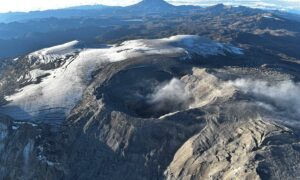
JMA reported that the number of earthquakes with shallow hypocenters and epicenters near Ponmachineshiri Crater, a summit crater of Me-Akan (also known as Meakan-dake, which means Meakan Peak) of the Akan volcanic complex, increased at 18h00 on 20 November. Another seismic increase occurred on 23 November, in number and amplitude of events, prompting JMA to raise the Alert Level to 2 (the second lowest level on a 5-level scale).
Akan is a 13 x 24 km caldera located immediately SW of Kussharo caldera. The elongated, irregular outline of the caldera rim reflects its incremental formation during major explosive eruptions from the early to mid-Pleistocene. Growth of four post-caldera stratovolcanoes, three at the SW end of the caldera and the other at the NE side, has restricted the size of the caldera lake. Conical Oakandake was frequently active during the Holocene. The 1-km-wide Nakamachineshiri crater of Meakandake was formed during a major pumice-and-scoria eruption about 13,500 years ago. Within the Akan volcanic complex, only the Meakandake group, east of Lake Akan, has been historically active, producing mild phreatic eruptions since the beginning of the 19th century. Meakandake is composed of nine overlapping cones. The main cone of Meakandake proper has a triple crater at its summit. Historical eruptions at Meakandake have consisted of minor phreatic explosions, but four major magmatic eruptions including pyroclastic flows have occurred during the Holocene.
Source: AJapan Meteorological Agency (JMA), GVP.
Photo : GSI by H.Seo 2007.
Mexico , Popocatepetl :
December 06, 11:00 am (December 06, 17:00 GMT)
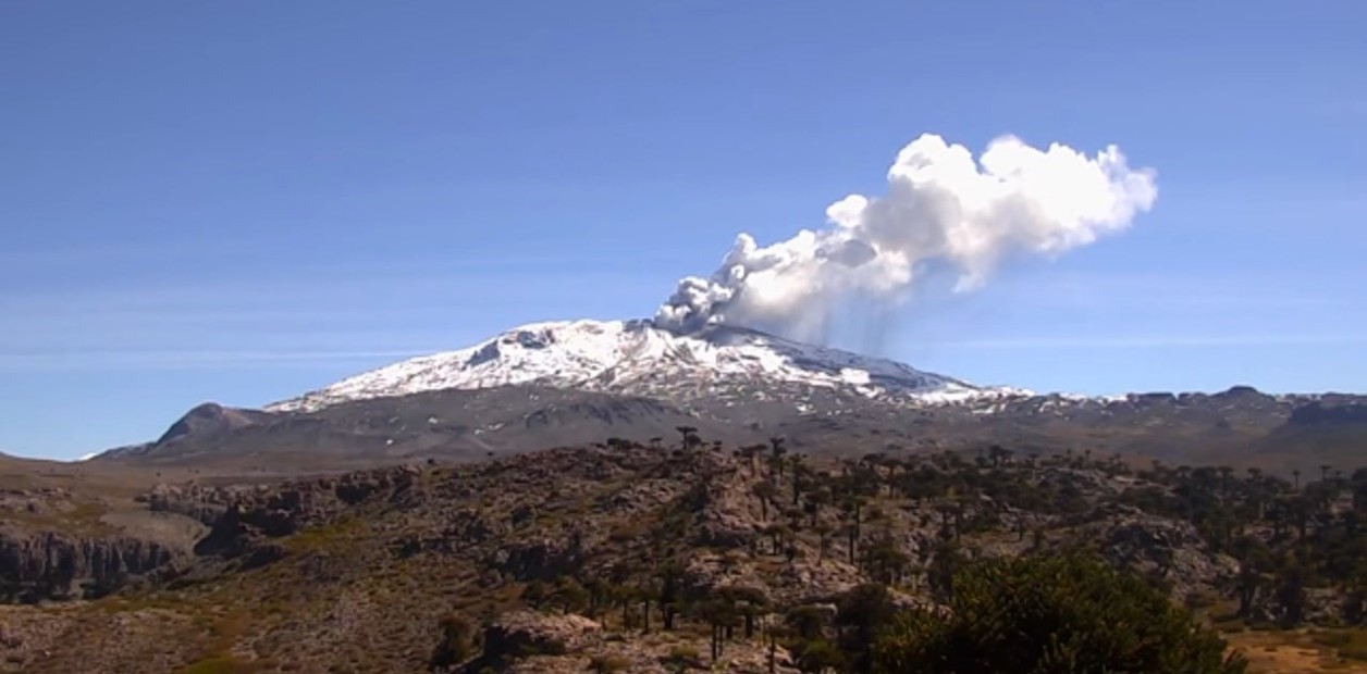
In the last 24 hours, thanks to the monitoring systems of the Popocatepetl volcano, 65 low-intensity exhalations have been identified, accompanied by water vapor and gas, as well as two explosions recorded yesterday at 10:56 and 19:10, the latter has emitted incandescent fragments that fell back into the crater.
In addition, 187 minutes of harmonic tremor of low amplitude were recorded.
During the night, an incandescence was observed on the crater, which increased during certain exhalations.
Due to cloud conditions in the region, at the time of writing this report, partial visibility of the volcano was available. However, early in the morning, volcanic gas emissions could be observed in a northwesterly direction.
CENAPRED urges NOT to APPROACH the volcano and in particular the crater, because of the risk of falling ballistic fragments, and in case of heavy rains, to move away from the bottom of the ravines because of the risk of landslides and of mudslides.
The Popocatepetl volcanic warning light is located at Amarillo Phase 2.
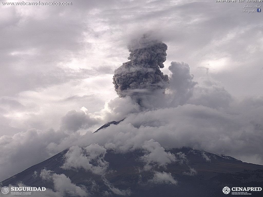
The national civil protection system announced that the Popocatépetl volcano had had a 2.5 km high expiry on Thursday, with a moderate ash content, heading north-west.
The civil protection coordinator of the State of Mexico, Luis Felipe Puente, said on his Twitter account that the volcano had an explosion Thursday at 13:17, with a high ash content.
He said that before the likelihood of ash falling from this morning’s activity on the volcano, it is recommended to cover the nose and mouth with a wet tissue or mask.
The Popocatépetl volcano showed 65 low-intensity exhalation accompanied by water vapor and gas, as well as two explosions, reported the National Center for Disaster Reduction (Cenapred) in the past 24 hours.
Source : Cenapred. El Heraldo .
Photo : Webcamdemexico.
Indonesia , Gamalama :
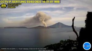
Level II Activity Level (WASPADA). The Gamalama (1715 m altitude) underwent a minor eruption on October 4, 2018 at 11:52, with an ash column observed reaching 250 meters above the summit or 1965 m above sea level.
Since yesterday and until this morning, the volcano was clearly visible until the appearance of fog. Crater smoke was observed to be low to medium, white, with a height of 50 from the top of the crater. The wind was blowing weakly to moderately towards the Southwest.

The seismographs, December 6, 2018, recorded:
1 earthquake low frequency
3 deep volcanic earthquakes
1 shallow volcanic earthquake
3 local tectonic earthquakes
23 distant tectonic earthquakes
3 emission earthquakes
Recommendation:
Communities around G.Gamalama and visitors / tourists should not have activities within a radius of 1.5 km around G.Gamalama crater. During the rainy season, people in the G. Gamalama area around the river are aware of the potential secondary threat of lahars.
VONA:
The latest VONA code, color code YELLOW, was published on October 10, 2018 at 19:26 and related to the continuous emission of smoke from the crater around 1725 m above sea level or about 10 m above Summit.
Source : PVMBG
Photo : Sumber