November 22 , 2018 .
Colombia , Nevado del Ruiz :
Subject: Activity bulletin of the Nevado del Ruiz volcano.
The level of activity continues at the level: Yellow activity level or (III): Changes in the behavior of volcanic activity.
With regard to monitoring the activity of the Nevado del Ruiz volcano, the COLOMBIAN GEOLOGICAL SERVICE announces that:
Over the past week, the seismicity caused by rock fracturing has resulted in an increase in the number of earthquakes and released seismic energy compared to the previous week. On November 13 and 14, this seismicity increased, it was located in the East-North-East sector 4.5 km from the Arenas crater, at depths between 3.7 and 6.7 km. The maximum magnitude recorded during the week was 2.1 ML (local magnitude), corresponding to the earthquake recorded on 14 November at 14:51 (local time) during the said increase. Other active sources during the week were the Northeast Zone and Arenas Crater, at depths between 1.1 and 5.2 km.
Seismicity related to fluid dynamics, within the channels of the volcanic structure, showed a similar level of earthquake numbers and released seismic energy compared to the previous week. This activity was characterized by the occurrence of earthquakes of variable energy levels, long period type (LP), very long period (VLP) and tremors. The earthquakes were mainly located in the crater Arenas and its surroundings.
Volcanic deformations measured from electronic inclinometers, GNSS (Global Navigation Satellite System) stations and radar images have so far shown stability behavior without recording significant deformation processes of the volcanic structure.
The volcano continues to emit water vapor and gases into the atmosphere, among which is the sulfur dioxide (SO2), as evidenced by the values obtained by the SCANDOAS stations installed in the region of the volcano. satellite image analysis. During the week, the NASA FIRMS and MIROVA portals reported two low-energy thermal anomalies.
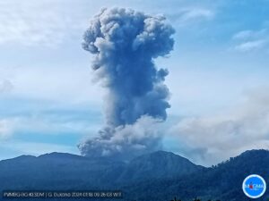
The column of gas, steam and ash reached a maximum height of 900 m, measured at the top of the volcano on November 17. The direction of column dispersion was governed by the direction of the wind in the area, which predominated to the northwest and southwest.
The Nevado del Ruiz volcano continues at the level of yellow activity.
Source : SGC
Alaska , Veniaminof :
AVO/USGS Volcanic Activity Notice
Current Volcano Alert Level: WARNING
Previous Volcano Alert Level: WATCH
Current Aviation Color Code: RED
Previous Aviation Color Code: ORANGE
Issued: Wednesday, November 21, 2018, 10:15 AM AKST
Source: Alaska Volcano Observatory
Location: N 56 deg 11 min W 159 deg 23 min
Elevation: 8225 ft (2507 m)
Area: Alaska Peninsula
Volcanic Activity Summary:
Overnight, ash emissions from Veniaminof increased significantly, generating a plume up to 15,000 ft asl and extending for more than 150 miles to the SE. This morning observers in Perryville and webcam views indicated continuous ash emissions. This activity is a significant increase from the past month and AVO is raising the Aviation Color Code to Red and the Volcano Alert Level to Warning.
A SIGMET warning for aviation has been issued by the National Weather Service. Please reference https://www.weather.gov/aawu/sigmets for updated guidance on airborne ash hazards.
Recent Observations:
[Volcanic cloud height] Up to ~15,000 ft
[Other volcanic cloud information] Continuous ash emissions observed in webcam
Remarks: Ash fall is possible in nearby communities. The National Weather Service Anchorage Forecast Office will issue an advisory if this is expected to occur.
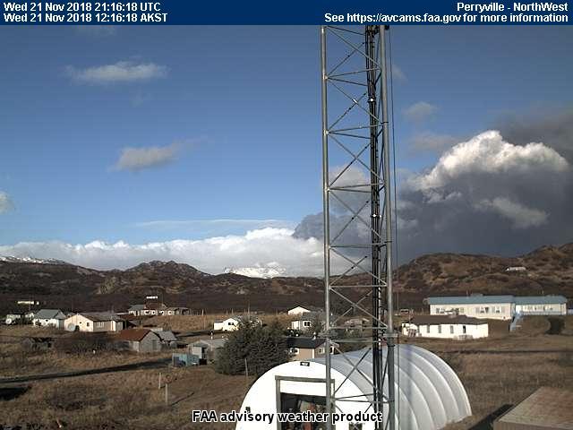
Seismic activity has remained elevated in the past 24 hours, and ramped up around 08:00 UTC before falling slightly throughout the day today. By 11:43 UTC an ash plume was observed in satellite data extending 80 miles to the SE, with maximum height estimated at 13,000 ft asl. This plume continued to develop throughout the night extending to over 150 miles. In response, the national weather service issued a SIGMET. Clear webcam views in the morning indicated continued ash emission to the SE, and a second plume developed extending over 120 miles to the SE. A pilot report from the morning indicated that the ash cloud was below 10,000 ft.
ANCHORAGE, Alaska (AP) — Residents of a tiny Alaska Native community woke up to a little pre-Thanksgiving excitement Wednesday, with a neighboring volcano spewing a billowing dark cloud high into the air.
The sooty emissions from Mount Veniaminof were visible from the Aleut village of Perryville nearly 25 miles (40 kilometers) to the south, locals said. But the wind was pushing the plume away from the community of 101 people.
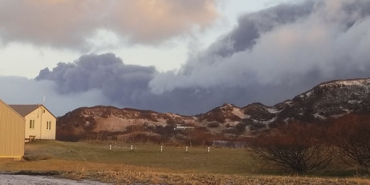
« It’s a big, black, ugly cloud, » lifelong resident Victoria Tague said of the ash, which later slipped behind a cloud cover.
Alaska Volcano Observatory scientists said that overnight emissions from Veniaminof generated an ash plume up to 15,000 feet (4,572 meters). The cloud drifted more than 150 miles (241 kilometers) to the southeast.
The ash emissions prompted an aviation warning. Observatory geophysicist Dave Schneider said that level of emissions would affect mostly smaller aircraft. Ash above 20,000 feet (6,100 meters) could threaten jet airplanes.
Veniaminof is 480 miles (772 kilometers) southwest of Anchorage on the Alaska Peninsula. It became active again in early September.
Source : AVO , wsfa.com .
Photos : Victoria Tague.
Ecuador , Sangay :
Special report, Sangay volcano N ° 2 – 2018
The eruptive process continues.
Summary.
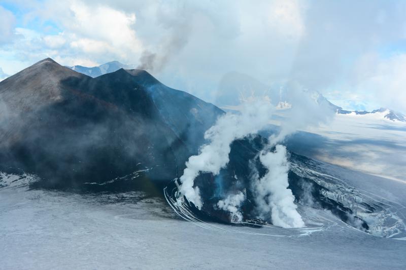
The Sangay volcano, located in the province of Morona Santiago, 40 km northwest of the city of Macas, continues the eruptive phase started on August 8, 2018 (Special Report No. 1-2018). The main volcanic phenomena associated with this activity are the continuous extrusion of lava flows from the east-south-east flank and the emission of ash columns directed mainly towards the west. These volcanic phenomena do not pose a threat to the population because they are limited to the vicinity of the volcanic cone. On September 18, a slight ash drop was reported in the city of Guayaquil, which did not cause any type of damage.
Background.
According to satellite monitoring of thermal warnings, the eruptive activity of the Sangay volcano has changed behavior. For several decades, this volcano has been continuously erupting with short periods of rest (Figure 1). However, since 2015, this behavior has shifted to cyclical behavior (Figure 1), characterized by periods of intense activity (2 to 3 months) followed by periods of rest between 9 and 13 months.
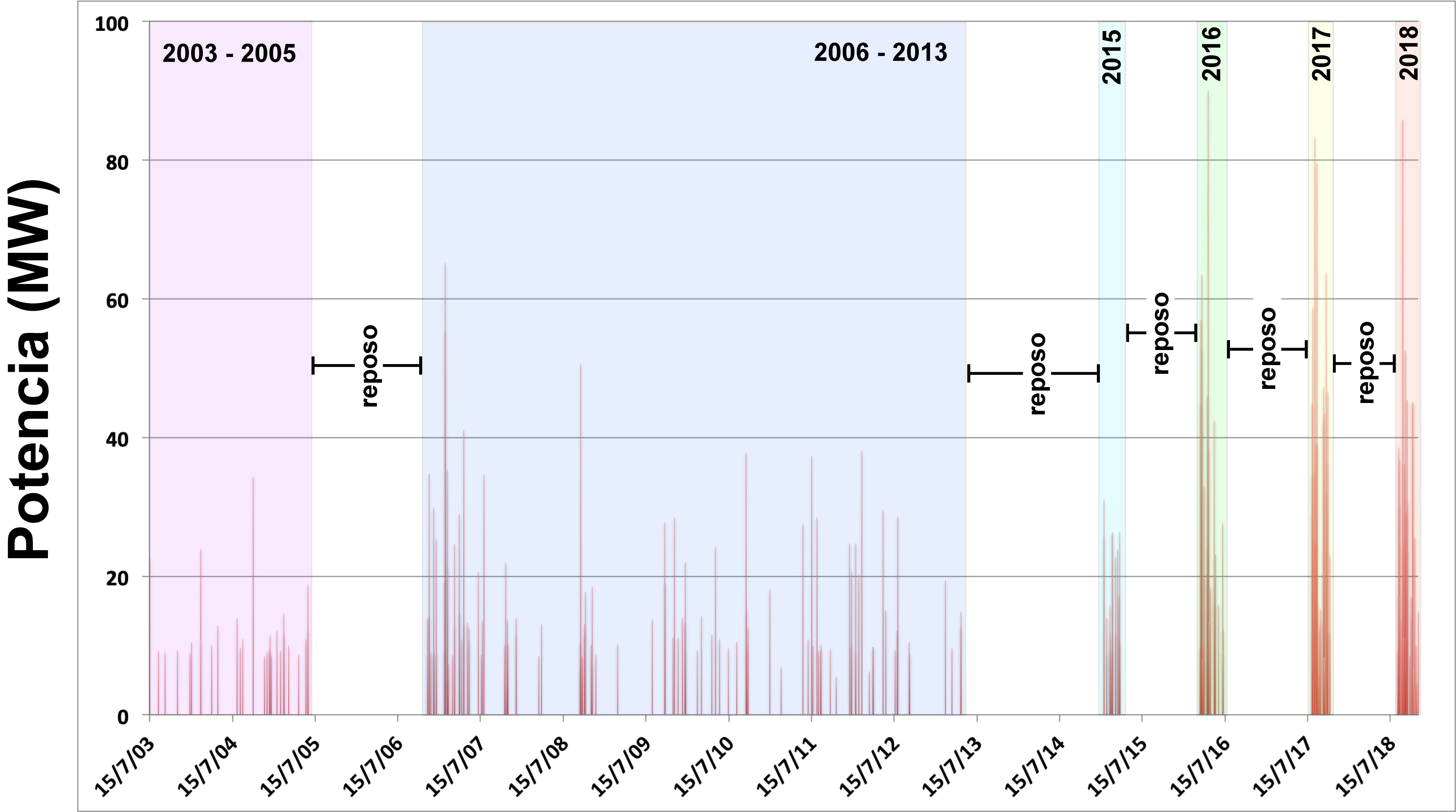
Figure 1. Thermal anomalies recorded by the MODVOLC satellite system. The colored rectangles separate the eruptive activity stages recorded from 2003 to the present day (2018). Highlights the change in behavior of the volcano since 2015. Data available at: http://modis.higp.hawaii.edu/.
Visual observations and surface activity.
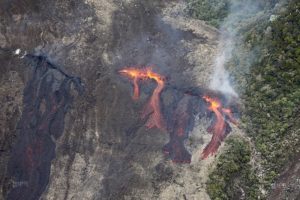
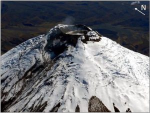
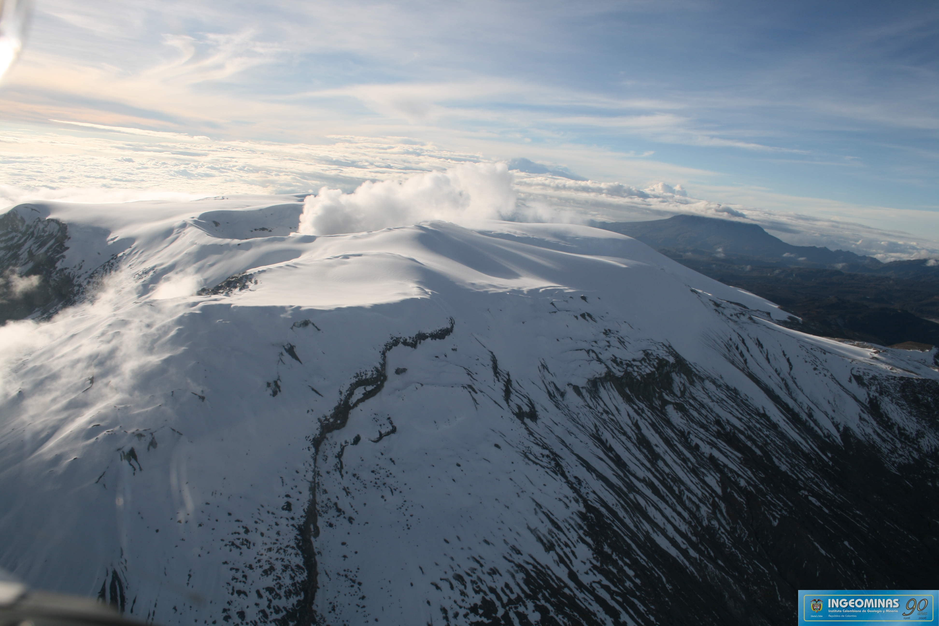
The Sangay volcano began a new eruptive phase on August 8 this year after 9 months of calm. The most significant surface activity during this period is the emission of ash columns about 1 km +/- 0.5 km above the summit, mainly towards the west and north-west of the volcano (Figures 2a and 3), This is the predominant direction of the wind. During this eruptive period of more than 90 days, VAAC Washington recorded 156 alerts due to ash columns (Figure 3). For example, on September 18, a slight ash drop was reported in the city of Guayaquil, 170 km west of the volcano. In addition, a continuous emission (3 months) of lava flows was recorded from a lateral vent on the East-South-East flank of the volcano (see Figures 2b, 2c and 2d). The lava flows have dropped 1 to 2 km below the crater level, while the phenomena associated with its location, such as: the rolling of blocks and the possible generation of pyroclastic flows due to the collapse of the lava front , reached distances up to 7 km below the crater level according to the information recorded by the MIROVA satellite system.
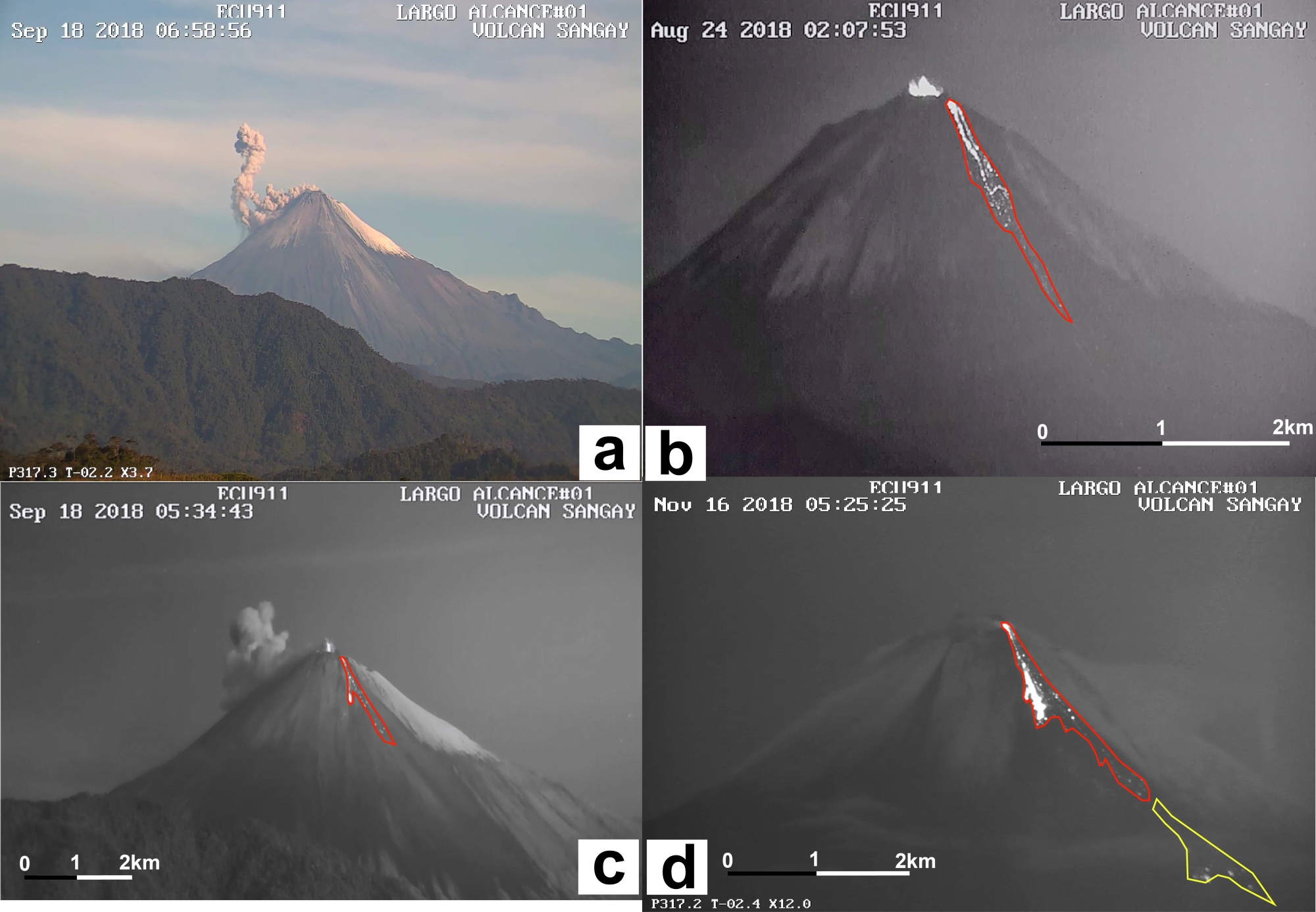
Figure 2. Photographs of the surface activity of the Sangay volcano during the eruptive period from August to November 2018, courtesy of ECU-911. The red polygon delineates the lava flow, while the yellow polygon represents the areas affected by secondary phenomena associated with the location of the flow, such as: descent of blocks and / or possible collapses of the lava front. a) Emission of ash columns more than 1 km high with a west direction (18 September), b) an eruptive activity is maintained with small explosions in the main crater and emissions of lava flows by the lateral vent (24 August), (c) the emission of ash columns in the main crater and the extrusion of lava flows across the East-South-East flank (18 September), (d) the emission of lava flow to the East-South-East of the volcano (November 16).

Figure 3. Sangay volcano ash column alert logging according to VAAC Washington. a) Monthly height of the ash columns. In red, the average height value appears, the frame represents the standard deviation, and the empty circles represent the maximum height values. (b) Map of Ecuador showing areas affected by ash fall during this eruptive period.
Seismic / acoustic activity.
The seismic activity of the Sangay volcano is characterized by the recording of more than 50 explosions per day (Figure 4), which generate the emission of ash columns. In addition, other seismic events related to fluid motion (LP) and rock fracturing (VT) are reported, in addition to seismic movements related to the location of the lava flow on the East-South flank. East (tremor).
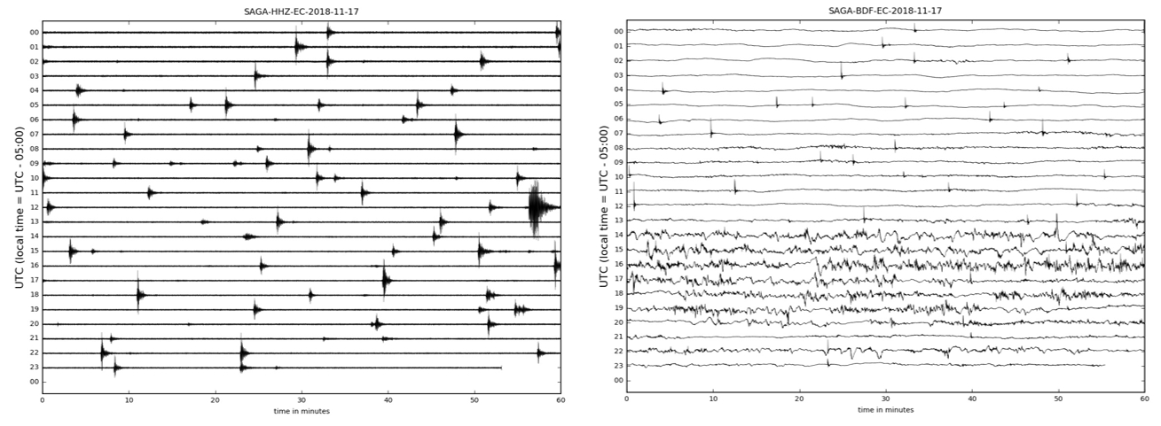
Figure 4. Seismogram of the SAGA seismic station showing typical activity during the current eruptive period of the Sangay volcano. The recording shows the behavior of the volcano on November 17, 2018 in its seismic (left) and acoustic (right) components. Source: Institute of Geophysics.
Interpretation.
As seismic activity levels remain high and there is no decrease in thermal warnings, the IG-EPN considers that the Sangay volcano eruption continues, being the longest since 2015 with more than three months of activity.
Conclusions.
The Sangay volcano eruption began on August 8 this year and lasted more than 90 days, with no signs of increase or decrease. This is characterized by the emission of ash columns 1 ± 0.5 km high, as well as lava flows, by a lateral vent on the East-South-East flank of the volcano. The lava flows descended 2 km below the crater level and generated secondary phenomena, such as block rolling and partial collapse of the lava front, which reached as much as 7 km below the level of the crater. crater.
The Institute of Geophysics at the École Polytechnique Nationale is monitoring the evolution of the current eruptive process on the Sangay volcano.
Source : IGEPN.
Guatemala , Fuego :
VOLCANOLOGICAL SPECIAL BULLETIN BEFGO # 218-2018, STRONG AVALANCHES. Guatemala , November 21 , 2018 at 10:50 AM (Local time)
Type of activity: Vulcanian
Morphology: Composite Stratovolcano
Location: 14 ° 28’54˝ Latitude N; 90 ° 52’54˝ Longitude W.
Height: 3,763msnm.
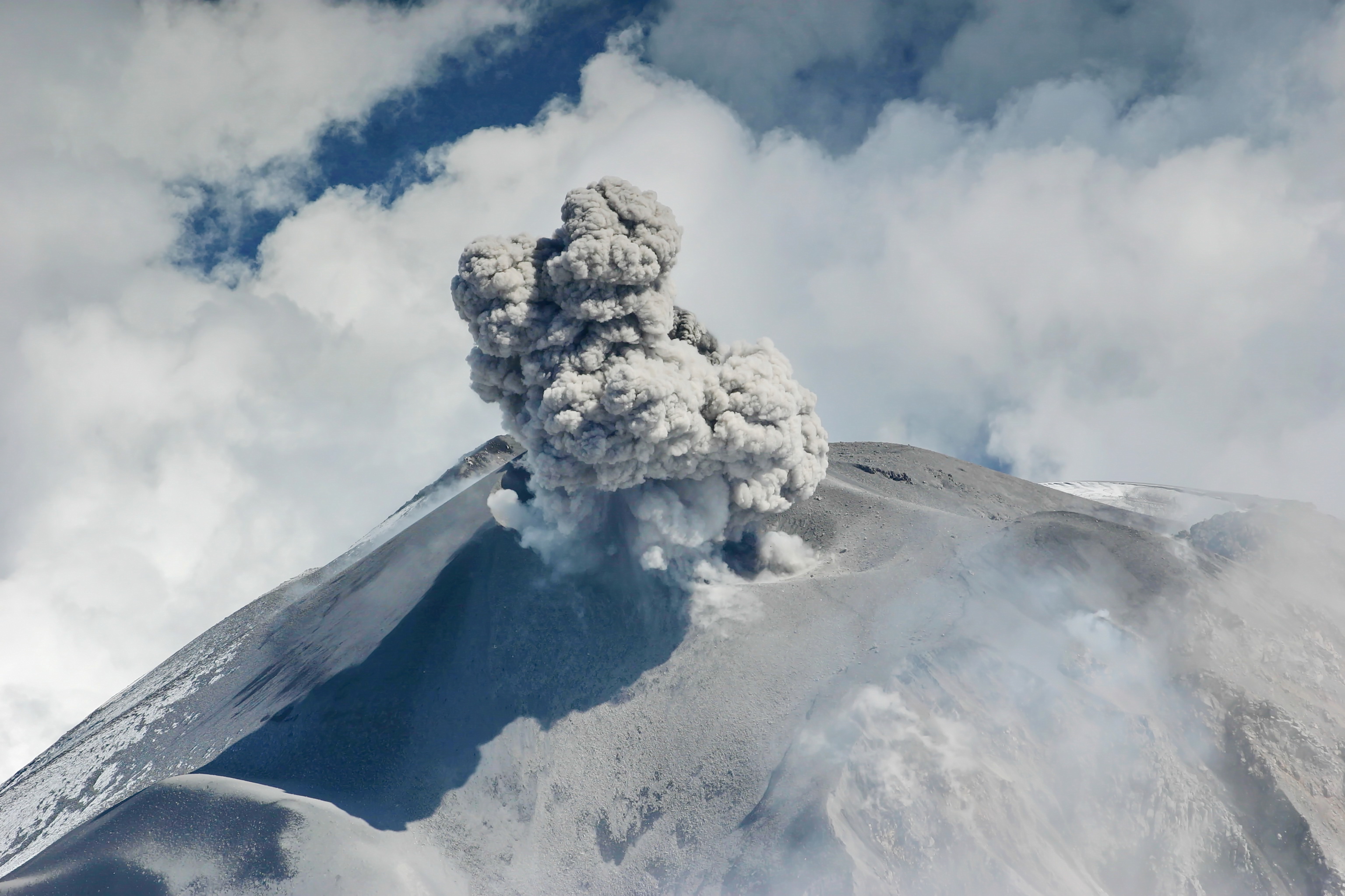
The Fuego volcano has weak and moderate explosions generating ash columns at an approximate height of 4,500 to 4,600 m (14,763 to 15,091 feet), traveling 12 kilometers to the west and south. Where is. During the night and early morning, we observed an incandescence in the crater and moderate avalanches in the direction of the main ravines. Because of the 5th eruption, the lava flows will disappear in the next hours and fine particles are released in the ravines.
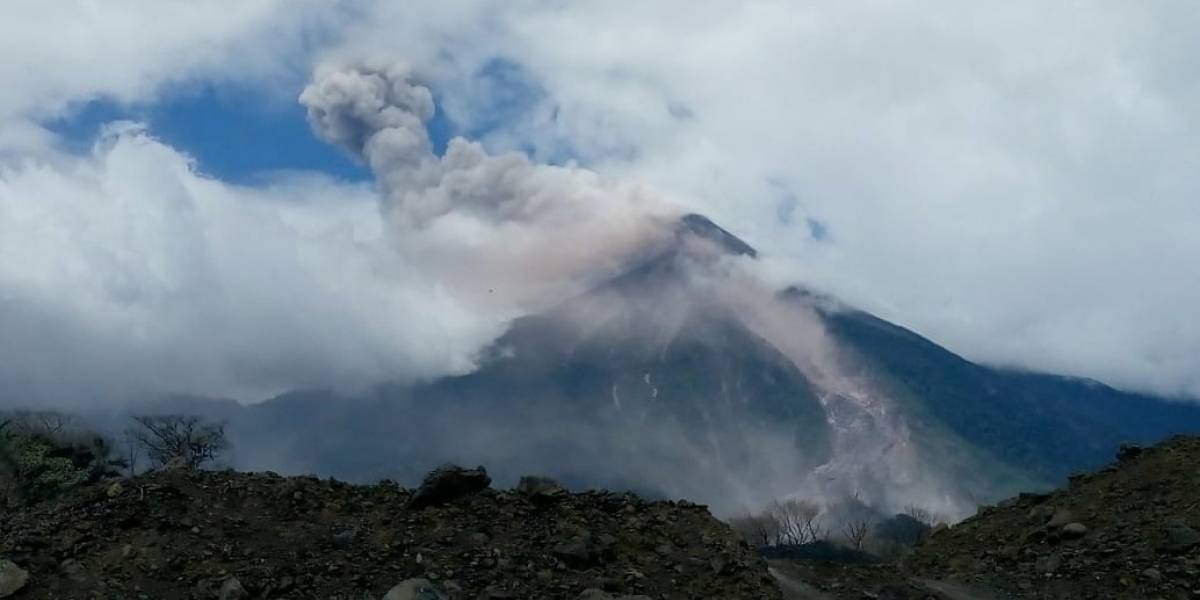
There are avalanches that travel long distances in the Seca, Ceniza, El Jute, Las Lajas and Honda gullies. These avalanches have strong characteristics, moving blocks of about 2/3 meters and raising fine particles in the South-South-West direction. This activity is associated with the instability that exists in the ravines of the Fuego volcano.
It is possible that this avalanche activity will continue for the following hours and even days. It is therefore recommended not to stay near the main ravines.
INSIVUMEH ensures constant monitoring of this activity.
Source : INSIVUMEH
Photo : Conred.