April 05 , 2018.
Cleveland, Aleutian Islands :
VOLCANO OBSERVATORY NOTICE FOR AVIATION (VONA) .
Issued: April 04 , 2018
Volcano:Cleveland (VNUM #311240)
Current Color Code:ORANGE
Previous Color Code:YELLOW
Source:Alaska Volcano Observatory
Volcano Location:N 52 deg 49 min W 169 deg 56 min
Area: Aleutians
Summit Elevation:5676 ft (1730 m)
Volcanic Activity Summary:
Local seismic and infrasound sensors recorded a small explosion today at 11:55 UTC (03:55 AKST). We are raising the Aviation Color Code to ORANGE and the Alert Level to WATCH.
Explosions from Cleveland typically produce relatively small volcanic ash clouds that dissipate within hours. No ash cloud from this event has been seen in satellite images, which currently are partly obscured by weather clouds.
Cleveland volcano is monitored with a limited real-time seismic network, which inhibits AVO’s ability to detect precursory unrest that may lead to an explosive eruption. Rapid detection of an ash-producing eruption may be possible using a combination of seismic, infrasound, lightning, and satellite data.
Volcanic cloud height: None
Other volcanic cloud information: n/a
A short-lived explosion occurred at Cleveland volcano today at 11:55 UTC / 03:55 AKST and was detected on local seismic and infrasound stations, as well as on regional infrasound stations. A satellite image acquired shortly after the eruption indicates hot material ejected during the explosion was deposited on the western flank of the volcano, possibly extending as far as the coastline. Subsequent satellite images show a small ash cloud moving to the southwest of the summit at or below 15,000′ asl. No significant activity has been detected since the initial explosion.
Source : AVO
Photo : Lyons, John , July 25, 2016.
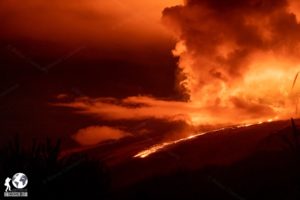
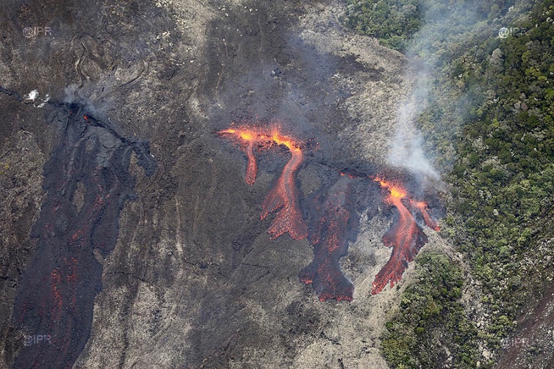
Piton de la Fournaise , La Réunion :
Activity Bulletin from Wednesday, April 4, 2018 at 4:00 pm (local time)
Seismicity:
Following the cessation of surface eruptive activity today, April 4, 2018 at 4:00 am (local time), seismic activity is still recorded on the Observatory’s equipment, particularly in the Piton Crac area (in red in Figure 1).
Thus 10 earthquakes were recorded between 04h and 09h (local time).
Falls at the level of the Nez Coupe Sainte Rose are also still recorded (12 events between 04h and 09h, local time).
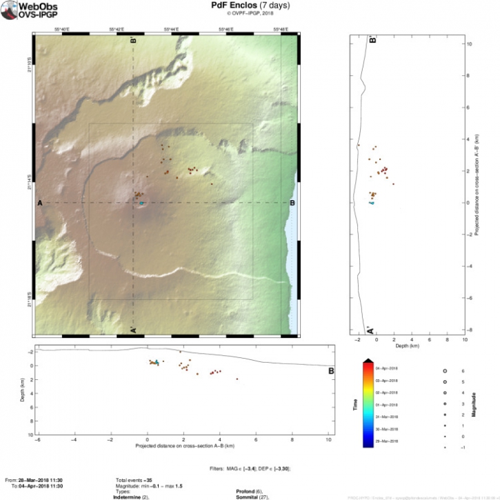
Figure 1: Location of seismicity over a week. Only « locatable » events are represented on this map. (© OVPF / IPGP)
However, the frequency of these earthquakes and landslides tends to decrease with 3 landslides at Nez Coupé de Sainte-Rose and 0 earthquakes registered between 09:00 and 15:30 (local time).
Deformation:
– No major deformation of the building is recorded.
Geochemistry of gases:
– The measurements of CO2 concentration in the soil made in the Gîte du volcan sector this morning show a gradual decline since the day yesterday.
– The levels of SO2 in the atmosphere have returned to their level of background noise this morning.
Prospect :
No assumptions are made about the evolution of the situation (definitive cessation of this episode, resumption of activity on this site or further downstream whether it is inside or outside the Enclos Fouqué ).
Source : OVPF
Photo : Ipreunion.
Shinmoedake , Japan
FUKUOKA (Kyodo) — Another powerful eruption was observed at Mt. Shinmoe in southwestern Japan early Thursday, with ash spewing up to around 5,000 meters high, the Japan Meteorological Agency said.
The eruption at the 1,421-meter-high volcano that straddles Miyazaki and Kagoshima prefectures on the southwestern Japan main island of Kyushu was the biggest since March 25, according to the agency.
Mt. Shinmoe erupted violently for the first time in about seven years on March 6, and the agency said a week later that it was expected to continue explosive eruptions for several months or more.
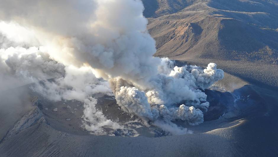
The agency maintained the alert level at the volcano at 3, which restricts access to the mountain, and issued warnings against large flying rocks within 3 kilometers of the crater and pyroclastic flow within 2 km of the crater.
Following the latest eruption at 3:31 a.m., rocks flew within around 1.1 km of the crater and the agency confirmed volcanic lighting caused by friction created by ash particles. It asked locals to be careful about volcanic ash and small rocks mainly on the leeward side.
Source : Mainichi.jp
Aira , ( Sakurajima) , Japan :
31.593°N, 130.657°E
Elevation 1117 m
JMA reported that there were 16 events at Minamidake crater (at Aira Caldera’s Sakurajima volcano) during 26 March-2 April, 12 of which were explosive. Tephra was ejected as far as 900 m from the crater. At 1541 on 26 March an explosion generated an ash plume that rose 3.4 km above the crater rim. An explosion recorded at 0740 on 1 April produced an ash plume that rose 3 km. Crater incandescence was visible the morning of 27 March and at night during 30 March-1 April.
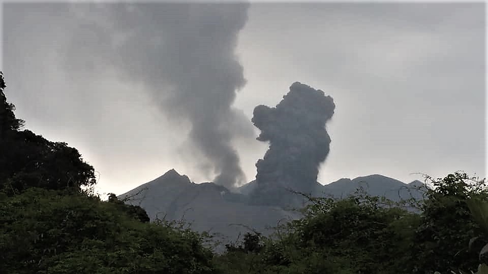
During 30 March-2 April there were three events at Showa crater. An event at 1611 on 1 April ejected tephra 300-500 m from the crater, and produced a very small pyroclastic flow (the first since 3 June 2016) that traveled 800 m E. A plume rose 1.7 km above the crater rim, up into weather clouds. The previous eruption at Showa crater occurred on 8 January.
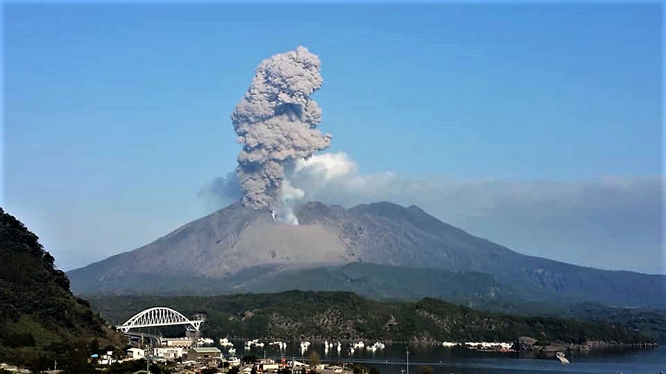
The Alert Level remained at 3 (on a 5-level scale).
Source: Agence météorologique japonaise (JMA) , GVP.
Photos : Yoshihide Murayama.
Galeras , Colombia :
Subject: Weekly activity bulletin of Galeras volcano.
The level of activity of the volcano continues at the level:
YELLOW LEVEL ■ (III): CHANGES IN THE CONDUCT OF VOLCANIC ACTIVITY.
Following the activity of the GALERAS volcano, the COLOMBIAN GEOLOGICAL SERVICE informs that:
For the period March 27 to April 2, 2018, low levels are continuing both in the presence of earthquakes and in the energy released. Recorded earthquakes were associated with fractures of solid materials inside the volcanic building and were located scattered around the active cone with depths less than 4 km from the summit (4200 m) and local amplitudes below M1.0 on the Richter scale.
Favorable climatic conditions made it possible to record the gas emission processes, with columns of low height and variable dispersion direction depending on the prevailing wind regime.
The COLOMBIAN GEOLOGICAL SERVICE is attentive to the evolution of the volcanic phenomenon and will continue to inform in a timely manner about the detected changes.
Source : SGC