October 20 , 2018.
Alaska , Véniaminof :
56°11’52 » N 159°23’35 » W,
Summit Elevation 8225 ft (2507 m)
Current Volcano Alert Level: WATCH
Current Aviation Color Code: ORANGE
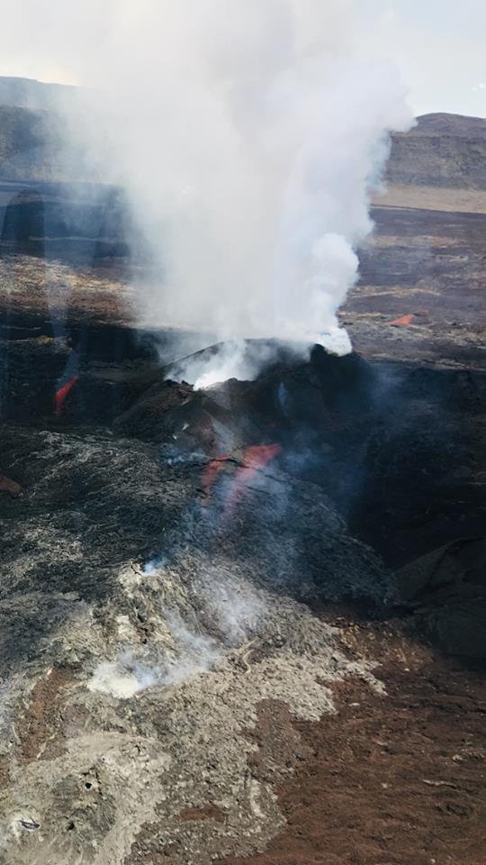
Low-level eruptive activity continues at the intracaldera cone of Veniaminof volcano. Analysis of recent satellite data indicates the western part of the lava flow field on the south flank of the intracaldera cone remains active. Satellite data have shown elevated surface temperatures throughout the week. Views of the volcano from the FAA web camera in Perryville showed persistent steam emissions. Emissions on October 18 were particularly robust with a plume dominated by steam extending up to 30 km to the northeast. Analysis of satellite data indicates that this plume was also accompanied by SO2 and possibly minor ash. Relatively continuous seismic tremor has been occurring throughout the week, further indicating that effusion of lava is continuing.
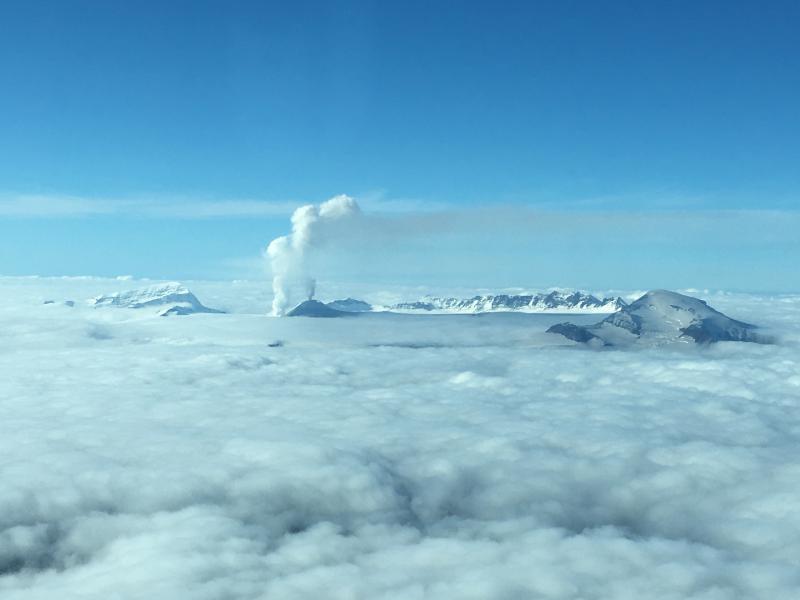
Mount Veniaminof volcano is an andesitic stratovolcano with an ice-filled 10-km diameter summit caldera located on the Alaska Peninsula, 775 km (480 mi) southwest of Anchorage and 35 km (22 mi) north of Perryville. Veniaminof is one of the largest (~300 cubic km; 77 cubic mi) and most active volcanic centers in the Aleutian Arc and has erupted at least 13 times in the past 200 years. Recent significant eruptions of the volcano occurred in 1993-95, 2005, and 2013. These were Strombolian eruptions that produced lava fountains and minor emissions of ash and gas from the main intracaldera cone. During the 1993-95 activity, a small lava flow was extruded, and in 2013, five small lava flows effused from the intracaldera cone over about five months. Minor ash-producing explosions occurred nearly annually between 2002 and 2010. Previous historical eruptions have produced ash plumes that reached 20,000 ft above sea level (1939 and 1956) and ash fallout that blanketed areas within about 40 km (25 mi) of the volcano (1939).
Source : AVO
Photo : Peterson, Mari
La Réunion , Piton de la Fournaise :
Activity bulletin from Friday 19 October 2018 at 15:45 (local time).
The eruption started on September 15th at 4:25 am local time continues. The intensity of the volcanic tremor (indicator of eruptive intensity at the surface) is still very slightly decreasing.
– No volcano-tectonic earthquake was recorded during the day of 18 October, nor during the current day.
– Inflation (swelling) of the building is always recorded. This inflation reflects the pressurization of a localized source beneath the summit craters (Bory-Dolomieu) at a depth of 1-1.5 km, related to the recharge of the superficial reservoir by deeper magma.
– The surface flow rates could not be estimated today because of lava flows that are too weak at the surface and significant cloud cover on site.
– No field reconnaissance has been done today.
Alert level: Alert 2-2 – Eruption in the Enclos .
Source et photo : OVPF. http://www.ipgp.fr/fr/ovpf/bulletin-dactivite-vendredi-19-octobre-2018-a-15h45-heure-locale
Chile, Osorno :
During this period, 77 seismic events were recorded, of which 72 were classified as long period type events (LP) in relation to the dynamics of the fluids inside the volcano and / or with the glacial dynamics. The larger magnitude event had reduced displacement values (DRC) equal to 5.4 cm2. In addition, it has been classified 5 volcano_tectonic (VT) type events, associated with the fracturing of rigid materials. The event of greatest energy had a local magnitude (ML) equal to M 1.2 and was located 1.1 km north – northwest of the crater at a depth of 4.4 km.
Surveillance camera images did not show any superficial activity when weather conditions allowed observation.
The indications of the electronic inclinometers did not reveal any changes in relation to changes in the internal dynamics of the volcano.
No emissions of sulfur dioxide (SO2) to the atmosphere in the volcano area have been reported, according to data published by the Ozone Monitoring Instrument (OMI) Sulfur Dioxide Group (http: / /so2.gsfc.nasa.gov/) and the National Satellite Environment and Information Data (NESDIS) (http: // satepsanoine nesdis.noaa.gov) ..
No thermal warnings have been reported in the volcano-associated area, according to data processed by Infrared, a means of observing volcanic activity (Mirova) (http://www.mirovaweb.it/) and MODVOLC (http : //modis.higp.hawaii.edu/).
Seismicity has decreased, both in terms of energy and number of earthquakes per day. As a result, local magnitude (ML) earthquakes greater than M 3.0 were not recorded. In this context, the activity trend shows stable behavior tending toward the base level of activity of the volcano.
For the above, the volcanic alert is reduced to the level:
GREEN LEVEL: Changes in the behavior of volcanic activity – Probable time for an eruption: WEEKS / MONTH.
Source : Sernageomin.
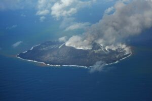
Indonesia , Anak Krakatau :
Level II Activity Level (WASPADA). Anak Krakatau (338 m) has experienced an increase in volcanic activity since 18 June 2018.
Since yesterday and until this morning, the volcano was visually covered with mist. The winds were weak and oriented towards North and East. The smoke from the crater is not observed.
Through a seismographic recording of 19 October 2018, it was noted:
63 earthquakes of eruption
5 deep volcanic earthquakes
12 shallow volcanic earthquakes
Continuous tremor signal of amplitude 2 to 55 mm (dominant value 10 mm)
Recommendation: People / tourists are not allowed to approach within a radius of 2 km around the crater.
VONA: The latest VONA message received the color code ORANGE, published on September 22, 2018 at 6:56, for an eruption with ash column height of approximately 538 m above sea level or approximately 200 m above the summit. The column of ashes was moving south.
A message from Sylvain Chermette, 80 jours Voyages : https://80joursvoyages.com/
Hello,
As you probably know, we have a confirmed Eruption Express departure from 10th to 17th November in Krakatau, Indonesia.
As the Sangeang Api seems to be offering a good show, I am going to extend the stay with some guests for an Exploration Express trip to Sangeang Api the following week from 17 to 23/11.
You did not register for the stay at Karkatau, but maybe you would be interested to join us for this extension to Sangeang Api from 16 to 23/11 (France / France).
In this case do not hesitate to contact me so that I give you the additional information on this stay.
Source : PVMBG
Vidéo : Fobos Planet.