October 05 , 2018.
La Réunion , Piton de la Fournaise :
Activity Bulletin from Thursday, October 4, 2018 at 16:30 (local time):
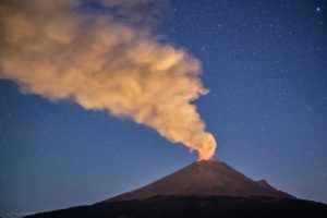
The eruption started on September 15th at 4:25 am local time continues. The intensity of the volcanic tremor (indicator of the eruptive intensity on the surface) is in marked increase since the day of yesterday 22h local time (18h UTC) and has doubled of intensity since. This increase could be related to the gradual closure of the eruptive cone, favoring a greater phenomenon of « resonance ». Piston gases (« gas flushes » or « tremor puffs ») at the eruptive site are always recorded by the OVPF seismometers. These « piston gases » mark a change of regime in the degassing of the eruption, and are generally observed when the quantity of available gas is exhausted, and often synonymous with a decrease of activity on the surface.
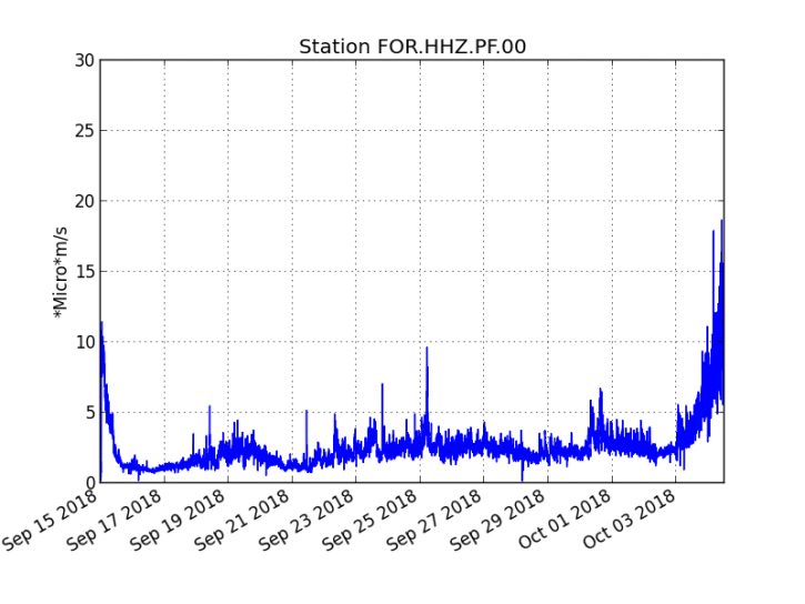
Figure 1: Evolution of the RSAM (indicator of the volcanic tremor and the intensity of the eruption) between 04:00 (00h UTC) September 15 and 16:00 (12:00 UTC) October 4 on the FOR seismic station, located near the crater Chateau Fort (2000 m altitude on the southeast flank of the terminal cone).
– No volcano-tectonic earthquake was recorded during the day of October 3, nor during the current day.
– An inflation (swelling) of the building, witnessing the influence of a source of pressure at the foot of the volcano, is still perceptible.
– The surface flows estimated from the satellite data, via the HOTVOLC platform (OPGC – Clermont Auvergne University) are between 1 m3 / s and 3 m3 / s over the last 24 hours.
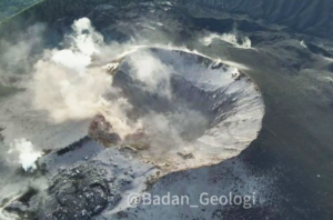
– The observations made yesterday at the end of the day and today by OVPF teams indicate a very weak surface activity, the lava projections inside the cone are rare and disperse over a very short distance and no major resurgence from the main tunnel was visible.
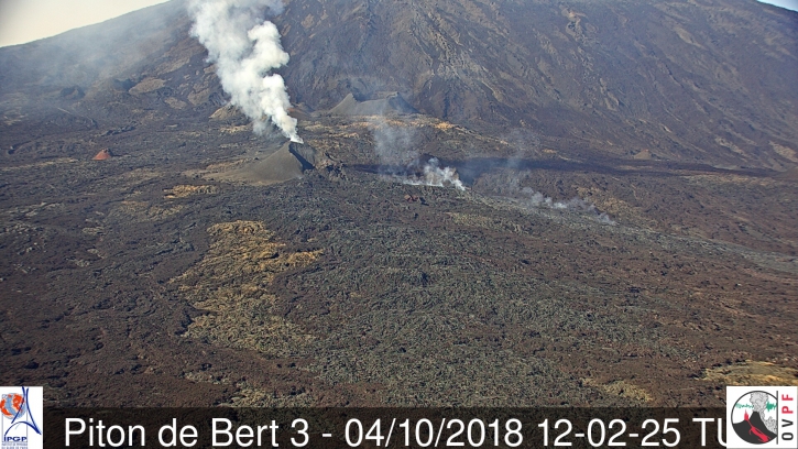
Figure 2: Shooting of the eruptive site on October 4, 2018 at 16:02 local time – 12:02 UTC time (© OVPF / IPGP-IRT).
Alert level: Alert 2-2 – Eruption in the Enclos.
Source : OVPF
Indonesia , Gamalama :
G. Gamalama , in the northern Maluku, erupted on October 4, 2018 at 11:52. A high ash column was observed ± 250 m above the peaks (± 1.965 m above sea level). The column of ash observed was of medium to thick intensity and was oriented towards the northwest.
Gamalama experienced a minor eruption, beginning with a very small increase in volcanic seismicity. About 1 hour before the eruption, it was recorded 8 volcanic earthquakes. The mechanism was probably a rash caused by steam. On the gas side, Gamalama is dominated by hydrothermal gas. The activity status does not need to be raised because the current recommendations are still adequate for the eruption. Monitoring will be increased to anticipate an increase in seismicity as a result of this minor eruption. People need to stay calm, stay alert and keep up to date on the evolution of Mount Gamalama’s activities.
https://www.facebook.com/andi.prayogo.549/videos/1868672533222331/
Currently, G. Gamalama is in Level II status (WASPADA) with recommendations:
Communities around Mt.Gamalama and visitors / tourists should not move within a radius of 1.5 km around the crater at the top of Mt.Gamalama
During the rainy season, people living around the rivers descending from Mt Gamalam must be aware of the potential threat of secondary hazards in the form of lahars.

The seismographic recording of October 4, 2018 noted:
1 eruption earthquake – 2 emission earthquakes.
8 shallow volcanic earthquakes
7 deep volcanic earthquakes
4 local tectonic earthquakes
6 distant tectonic earthquakes
Continuous tremor with a maximum amplitude of 1.5 to 15 mm, dominant value : 2 .
Source : PVMBG.
Colombia , Nevado del Ruiz :
Subject: Activity bulletin of the Nevado del Ruiz volcano.
The level of activity continues at the level: Yellow activity level or (III): changes in the behavior of volcanic activity.
With regard to monitoring the activity of the Nevado del Ruiz volcano, the COLOMBIAN GEOLOGICAL SERVICE announces that:
During the past week, the seismicity caused by the fracturing of the rocks that make up the volcano has had a similar behavior, both in number of earthquakes and released seismic energy, compared to the previous week. The earthquakes were mainly located in the sources of the North-East, South, South-East and in the Arenas crater, at depths between 0.5 and 4.5 km. The maximum magnitude recorded during the week was 1.1 ML (local magnitude) corresponding to an earthquake on September 29 at 18:32 (local time) in the Arenas crater, at a depth of 1.7 km.
Seismicity related to fluid dynamics, within the channels of the volcanic structure, showed a similar level of earthquake numbers and released seismic energy compared to the previous week. This activity was characterized by the presence of earthquakes with variable energy levels, long period (LP), very long period (VLP), volcanic tremor pulsations and episodes of continuous volcanic tremor. The earthquakes were mainly located in the crater Arenas and its surroundings. Some of these seismic signals were associated with low emissions of gas and ash in the atmosphere, as confirmed by the images captured by the cameras installed in the volcano area.
Volcanic deformations measured from electronic inclinometers, GNSS (Global Navigation Satellite System) stations and radar images have so far shown stability behavior without recording significant deformation processes of the volcanic structure.
During the week, the MIROVA portal reported several thermal anomalies of very low energy.
The column of gas, steam and ash reached a maximum height of 1300 m, measured at the summit of the volcano on 29 September.
The Nevado del Ruiz volcano continues its activity at the Yellow activity level.
Source : SGC
Ecuador , Cuicocha – Cotacachi :
Special file Volcán Cuicocha N ° 01 – 2018, seismic activity recorded on the volcano.
Summary:
On October 2 and 3, 2018, the Institute of Geophysics recorded an increase in the seismic activity of the Cuicocha – Cotacachi volcanic complex.
So far, there have been 60 events associated with rock fractures inside the volcano (VT). The maximum magnitude calculated for earthquakes is M 2.5.
Seismic monitoring:
The Cuicocha-Cotacachi volcanic complex has a permanent surveillance network composed of: 4 broadband seismic stations installed around the volcano (CUIC, CUSE, CUSW, COTA), 3 accelerographs located in nearby cities (ACOT, AOTA, ATUN ) 2 GPS stations designed to measure deformation (CCNE and CUIC) and 4 stations of the national seismograph network (OTAV, URCU, IMBA and YAHU).
The network described above has recorded since yesterday, October 2, an increase in seismic activity. As of the date of this report, 60 events have been recorded. The events were described as volcano-tectonic (VT) fracture related rock and no event associated with fluid movement inside the volcanic building was recorded (Figure 1).

Figure 1. Daily number of recorded earthquakes in the Cuicocha – Cotacachi volcanic complex since 2014. Seismicity increases compared to previous months.
Figure 2 shows the epicentral location of 10 events meeting the required parameters (observations of at least 4 stations). The earthquake of greatest magnitude is 2.5 ML and occurred on October 2 at 10:58 (TL). This earthquake was reported as very slightly felt by a Quiroga person.
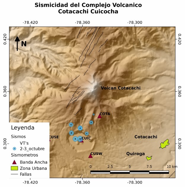
Figure 2. Epicentral location map of 10 events that occurred between 2 and 3 October in Imbabura province.
Conclusions:
The seismic activity of the Cuicocha-Cotacachi volcanic complex is increasing. Until the closure of this report, 60 volcano-tectonic events were counted. Ten events were located, one of which reached a magnitude of 2.5 MLv and was reported to be felt by the Quiroga population.
The Institute of Geophysics provides permanent monitoring of the volcanic complex and any changes in its activities will be informed in due course.
Source : IGGEPN , AC, EV , Institut de géophysique , Ecole Polytechnique Nationale
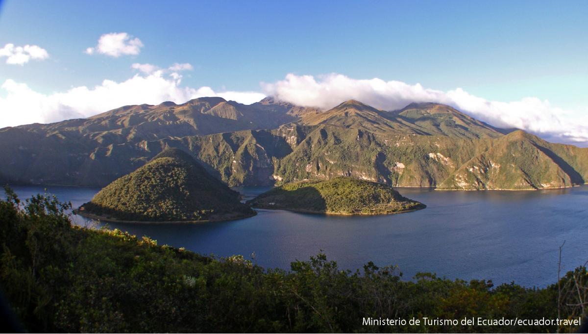
Photo : Ministère du tourisme de l’Equateur.
Mexico, Popocatepetl :
October 04, 11:00 am (October 04, 16:00 GMT)
During the last 24 hours, 173 exhalations were identified using the monitoring systems of the Popocatépetl volcano, accompanied by water vapor, gas and ash. Two explosions were also recorded yesterday at 9:04 pm today at 08:46, as well as two volcano-tectonic earthquakes, one yesterday at 11:19 and one today at 07:25 magnitudes 1.5 and 2.4 respectively. Finally, 358 minutes of harmonic tremor of low amplitude were recorded.
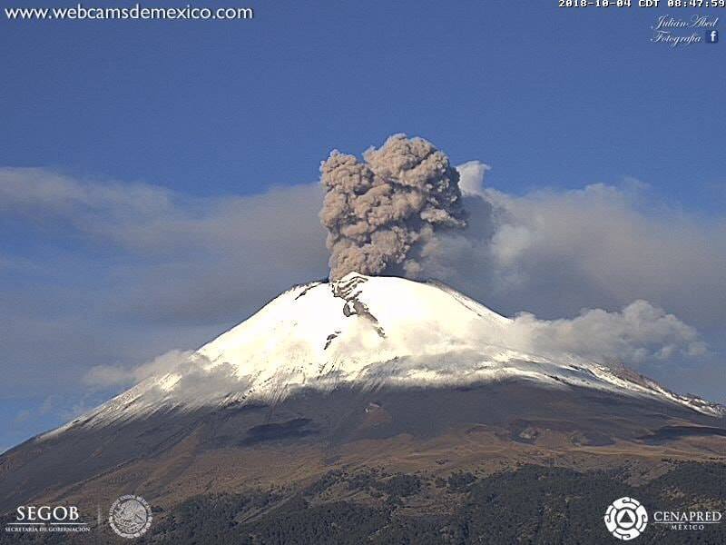
During the night, there was little visibility to the crater of the volcano, so that very little incandescence was observed at the time of certain events.
At the time of writing, it has been observed that steam, gas and ash emissions are dispersed to the West-South-West.
CENAPRED urges NOT to APPROACH the volcano and especially the crater, because of the risk of falling ballistic fragments and in case of heavy rains to move away from the bottom of the ravines due to the risk of landslides and sunken mud.
The warning light of the Popocatepetl volcano is located at Amarillo Phase 2.
Source : Cenapred
Photo : webcamdemexico.