July 03 , 2019.
Italy / Sicily , Etna :
02.07.2019 | Explosion in the Northeast Crater at 12:06 pm local time.
« COMMUNICATION OF VOLCANIC ACTIVITY from 02 July 2019 to 10:06:33 (UTC) – ETNA.
The National Institute of Geophysics and Volcanology, Osservatorio Etneo, announces that an eruptive pulse of ash from the Northeast Crater has been observed from the analysis of the images of the cameras of the surveillance network and the direct observations made by the INGV field staff at 10:06 UTC. The ashes emitted quickly dispersed in the area of the summit. The stations at the summit recorded a low frequency seismic signal. The explosion also generated a transient signal in the infrasound signal.
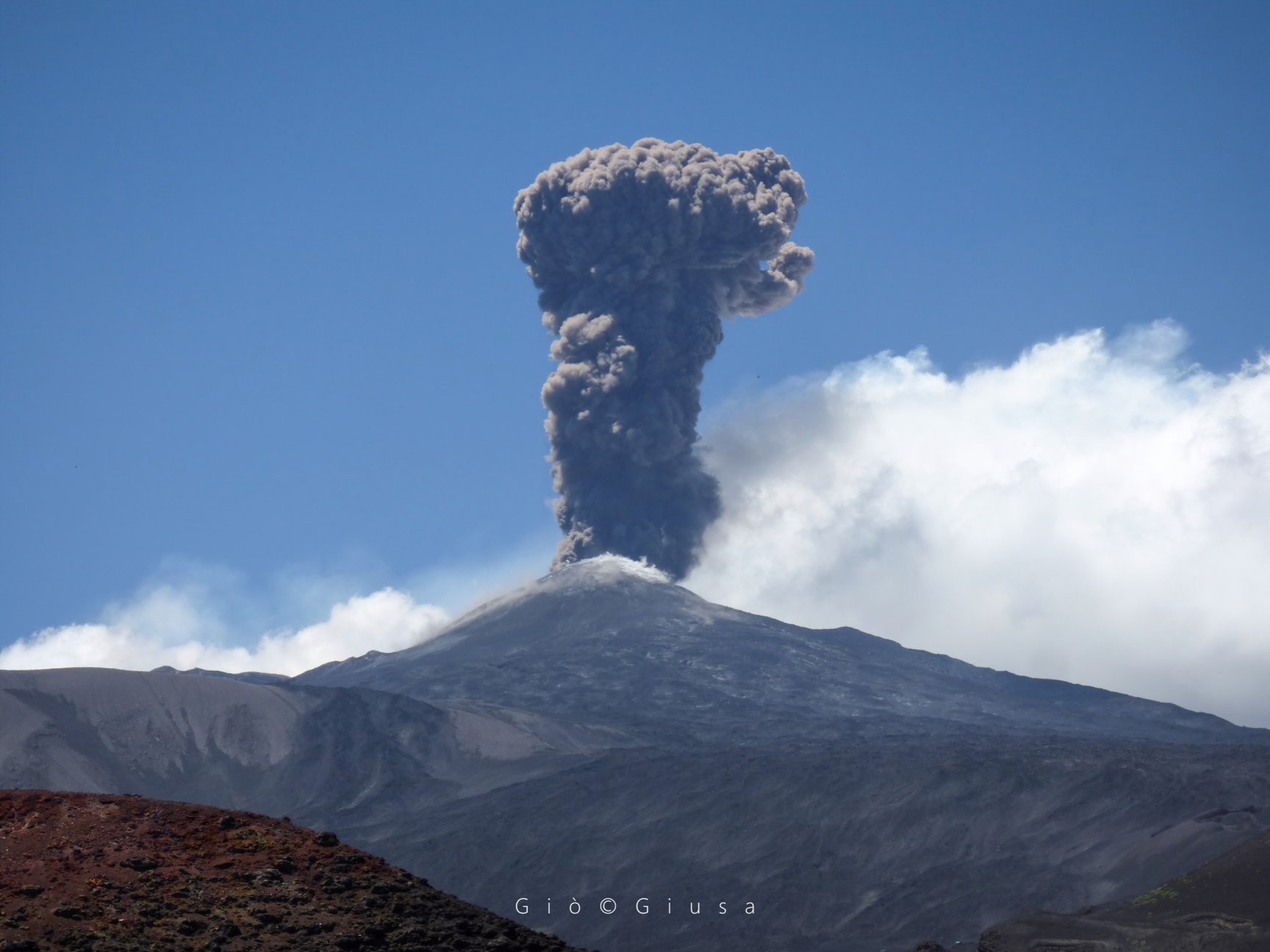
Etna, new eruptive phase.
Strombolian activity is present from Bocca Nuova, on Etna, with explosions and incandescent lapilli sprays falling near the crater, in the area at the top of the volcano. A column of lava ash also emerges as the wind moves away from inhabited centers.
The current eruptive phase of Mount Etna is safe for both people and residential areas and does not affect the operation of Catania Airport.
Source : INGV , gazzettinonline.it.
Photo : Gio Giusa .
Hawaii , Mauna Loa :
HVO/USGS Volcanic Activity Notice , Volcano: Mauna Loa (VNUM #332020) .
Current Volcano Alert Level: ADVISORY
Previous Volcano Alert Level: NORMAL
Current Aviation Color Code: YELLOW
Previous Aviation Color Code: GREEN
Issued: Tuesday, July 2, 2019, 7:40 AM HST
Source: Hawaiian Volcano Observatory
Notice Number: 2019/H28
Location: N 19 deg 28 min W 155 deg 36 min
Elevation: 13681 ft (4170 m)
Area: Hawaii
Volcanic Activity Summary: For the past several months, earthquake and ground deformation rates at Mauna Loa Volcano have exceeded long term background levels. An eruption is not imminent and current rates are not cause for alarm. However, they do indicate changes in the shallow magma storage system at Mauna Loa.

Following a significant earthquake swarm in October 2018, HVO seismic stations have recorded an average of at least 50 shallow, small-magnitude earthquakes per week beneath Mauna Loa’s summit, upper Southwest Rift Zone, and upper west flank. This compares to a rate of fewer than 20 per week in the first half of 2018. Shallow earthquakes are occurring in locations similar to those that preceded Mauna Loa’s most recent eruptions in 1975 and 1984.
During this same time period, GPS instrumentation and satellite radar have measured ground deformation consistent with renewed recharge of the volcano’s shallow magma storage system. The current rate and pattern of ground deformation is similar to that measured during inflation of Mauna Loa in 2005 and again from 2014 – 2018.
Together, these observations indicate the volcano is no longer at a background level of activity. Accordingly, HVO is elevating the Mauna Loa alert level to ADVISORY and the aviation color code to YELLOW.
This increase in alert level does not mean that an eruption is imminent nor that progression to an eruption is certain. A similar increase in activity occurred between 2014 and 2018 and no eruption occurred.

A vertical view of the whole Sulphur Cone area, including a sulphur flow out of one of the cones (yellow bottom of image). The white in the middle of the image is caused by alteration of the rock by volcanic gas.
Remarks: Prognosis
As has happened before, it is possible that current low-level unrest will continue and vary in intensity for many months, or even years without an eruption. It is also possible that the current unrest is an early precursor to an eventual eruption. At this time, we cannot determine which of these possibilities is more likely.
HVO expects that days or weeks prior to an eruption, monitoring instruments will detect signs of an increased potential for eruption. These signs could include further increases in rates of earthquakes and ground deformation, increases in the sizes of earthquakes, an increase in surface temperatures, or an increase in visible steam plumes or sulfur dioxide emissions.
However, it is also possible that the timeframe to eruption could be shorter – hours to days. All communities on the flanks of the volcano should be prepared.
HVO continues to monitor the volcano closely and will report any significant changes. HVO is in close touch with Hawaii County Civil Defense and other agencies responsible for public safety.
Hawaii County Civil Defense Agency is in constant communications with HVO. If anything develops that may affect your safety, you will be informed.
Source : USGS.
Photos : USGS
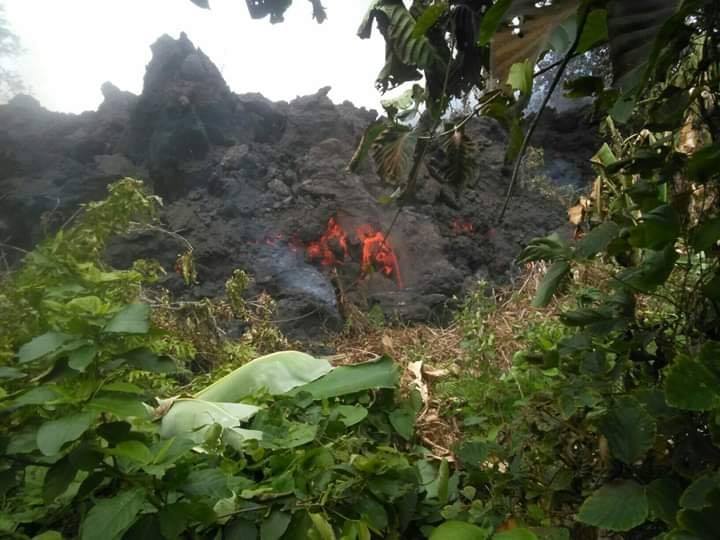
Papua New Guinea , Ulawun / Manam :
PNG Mt Ulawun and Manam Volcanoes updates .Monday, July 01, 2019 .
The volcanic eruption at Mt. Ulawun is considered over by the Rabaul Volcano Observatory.
According to the Volcano Information Bulletin from the Department of the Mineral Policy and GeoHazards Management, the volcano has remained quiet for days.
However, the Rabaul Volcano Observatory will continue to monitor the volcanic activity and will advise on any changes that may occur.
Information from the Bulletin shows that the eruption deposited a significant amount of ash on the upper slopes of the volcano and to a lesser extent downwind areas.
During heavy rain, the ash deposit could develop into mudflow’s which could become hazardous in low lying areas and people must be aware of these.
Meantime, according to RVO’s latest Volcano Information Bulletin on Manam Volcano in Madang Province, the higher than normal background seismicity suggests the Manam system is still dynamic and volatile and therefore the potential for further eruptive activity in the future is possible.
Since the eruption on the 28th, the main crater activity has been low marked by emissions of variable amounts of white vapor but occasionally thick dark grey emissions are seen emitted.
RVO has advised people to avoid venturing or doing activities in the four main valleys and the probability for mudflow generation from the ash and scoria deposits by heavy rains is high so people should remain alert during these times.
RVO will continue to monitor the activity and provide updates.
Source : news.pngfacts.com
Photo : NAUFM.
Peru , Ubinas :
Period of analysis: June 24 to 30, 2019. Arequipa, 1st of July 2019
Alert level: YELLOW
The Geophysical Institute of Peru (IGP) reports that the Ubinas volcano continues in an eruptive process. Currently, ash emissions and an increase in seismic activity related to the rise of magmatic fluids have been recorded. As a result, the authorities are advised to maintain the yellow alert level.
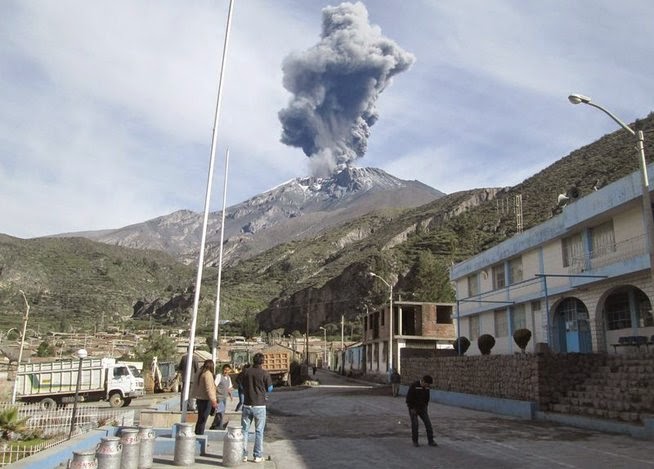
The IGP has analyzed seismic activity recorded between June 24th and 30th, 2019. Seismicity is reported to be linked to the movement of volcanic fluids (water vapor, gas and magma) with an average of 38 events per day . In the same way, the events associated with rock rupture processes inside the volcano remain high (VT types), with 200 earthquakes per day. Since June 24, surveillance cameras have recorded emissions of ash, gas and water vapor dispersed to the north and northeast of the crater. The monitoring of the deformation of the volcanic structure, using GNSS data (processed with fast orbits), presents no anomalies.
Satellite monitoring, using information from the SENTINEL system, corroborates the direction of dispersion of the ashes recorded by the surveillance cameras. The data obtained from TROPOMI (SO2) and MIROVA (thermal anomalies) do not show any significant changes in the analysis period.
Source : IGP.
Photo : Auteur Inconnu.