September 04 , 2018.
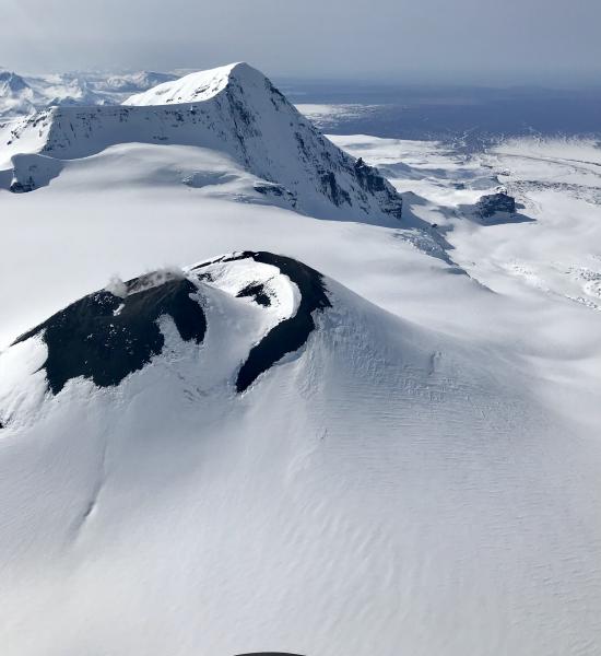
Alaska , Veniaminof :
AVO/USGS Volcanic Activity Notice
Current Volcano Alert Level: ADVISORY
Previous Volcano Alert Level: NORMAL
Current Aviation Color Code: YELLOW
Previous Aviation Color Code: GREEN
Issued: Monday, September 3, 2018, 11:29 AM AKDT
Source: Alaska Volcano Observatory
Notice Number:
Location: N 56 deg 11 min W 159 deg 23 min
Elevation: 8225 ft (2507 m)
Area: Alaska Peninsula
Volcanic Activity Summary:
Seismic activity at Veniaminof, indicative of unrest, increased late last night and volcanic tremor is ongoing. Thus, AVO is rasing the Aviation Color Code to Yellow and the Volcano Alert Level to Advisory. There are, however, no signs of eruptive activity at this time.
Recent Observations:
[Volcanic cloud height] Unknown
[Other volcanic cloud information] Unknown
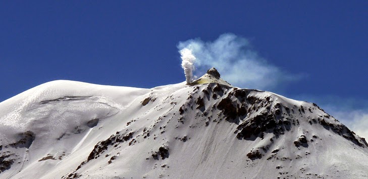
Remarks: Mount Veniaminof volcano is an andesitic stratovolcano with an ice-filled 10-km diameter summit caldera located on the Alaska Peninsula, 775 km (480 mi) southwest of Anchorage and 35 km (22 mi) north of Perryville. Veniaminof is one of the largest (~300 cubic km; 77 cubic mi) and most active volcanic centers in the Aleutian Arc and has erupted at least 13 times in the past 200 years. Recent significant eruptions of the volcano occurred in 1993-95, 2005, and 2013. These were Strombolian eruptions that produced lava fountains and minor emissions of ash and gas from the main intracaldera cone. During the 1993-95 activity, a small lava flow was extruded, and in 2013, five small lava flows effused from the intracaldera cone over about five months. Minor ash-producing explosions occurred nearly annually between 2002 and 2010. Previous historical eruptions have produced ash plumes that reached 20,000 ft above sea level (1939 and 1956) and ash fallout that blanketed areas within about 40 km (25 mi) of the volcano (1939).
Source : AVO
Photo : 2 Avril 2018 , Pepin, Dan
Peru , Sabancaya :
An average of 25 EXP / day was recorded. Earthquakes associated with the rise of magma (hybrid types) remain very few and low energy.
The eruptive columns of gas and ash reached a maximum height of 3000 m above the crater. The dispersion of these materials occurred within a radius of approximately 50 km, mainly in the Southeast, East and Northeast directions.

The volcanic gas (SO2) flow recorded on September 2 a maximum value of 3970 tons / day, a value considered important.
The deformation of the surface of the volcanic building presents a tendency associated with a deflationary process.
The MIROVA satellite system recorded 6 thermal anomalies, with values between 1 MW and 87 MW VRP (Radiated Volcano Power).
In general, eruptive activity maintains moderate levels. No significant changes are expected in the following days.
Source : IGP
Chile , Guallatiri :
Special Report on Volcanic Activity (REAV)
Arica and Parinacota Region, Guallatiri Volcano, 03 September 2018, 07h00 Local time (Continental Chile)
The National Geological and Mining Service of Chile (Sernageomin) publishes the following PRELIMINARY information, obtained from monitoring equipment of the National Volcanic Monitoring Network (NVRN), processed and analyzed at the Volcanological Observatory of the Southern Andes (OVDAS) :
On Monday 03 September 2018 at 00h27 Local time (03h27 UTC), the monitoring stations installed near the Guallatiri volcano recorded an earthquake associated with a fracturing mechanism of the rocks (volcano-tectonic type) inside the volcanic building.
The characteristics of the earthquake after its analysis are as follows:
TIME OF ORIGIN: 00h27 Local time (03h27 UTC)
LATITUDE: 18.321 ° S
LONGITUDE: 69.138 ° W
DEPTH: 13,0 KM
LOCAL MAGNITUDE: 3.6 (Ml)
OBSERVATIONS:
After recording the seismic event, at 4:54 local time (07:54 UTC), another similar seismic event was recorded with a magnitude of M 2.6. Finally, associated with the period of occurrence of these events, a dozen low-energy events have been recorded where also the seismic characteristics associated with them make it possible to conclude that the whole process would be framed by the same seismogenic phenomenon, typical activity. associated with an active volcano, as is the case of the Guallatiri volcano.
The level of volcanic technical alert remains at the level: GREEN.
Sernageomin continues online monitoring and will inform in a timely manner about any changes observed.
Source : Sernageomin
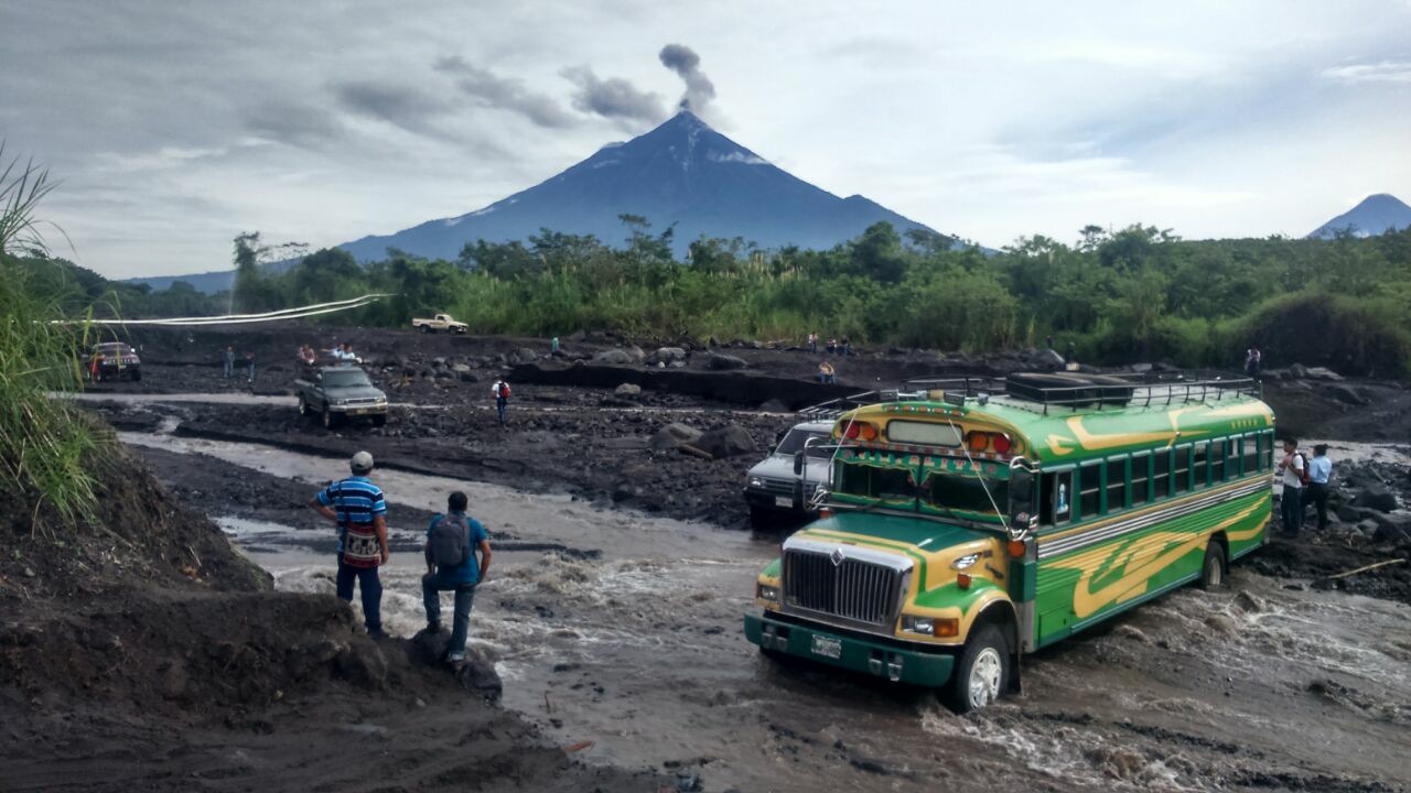
Guatemala , Fuego :
Three months after its violent eruption that killed at least 169 people, the Fuego volcano in Guatemala continues its activity on Monday, with frequent explosions, said an official source.
According to the National Institute of Seismology, Volcanology, Meteorology and Hydrology (INSIVUMEH), the volcano, located 50 kilometers west of the capital, showed between 10 and 15 explosions per hour, of low to moderate intensity .
The plumes of ash reach between 4,300 and 4,700 meters high and move for 12 kilometers west of the volcanic cone, located between the departments of Chimaltenango, Escuintla and Sacatepequez.
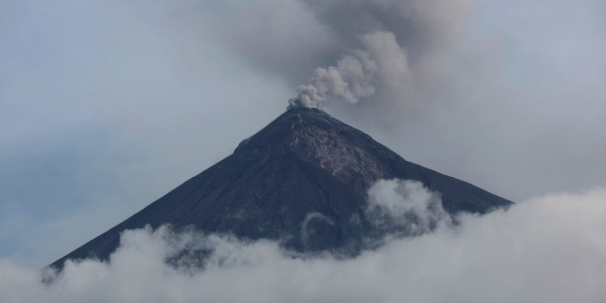
The scientific entity stated that some explosions generate glow and low avalanches around the crater.
So far, ash falls have been reported in the cities of San Pedro Yepocapa and Sangre de Cristo, he added.
Three months ago, the Fuego volcano, one of the most active of the 32 in Guatemala, recorded a powerful eruption that left 169 dead, 256 missing and more than 1.71 million people affected.
Meanwhile, survivors continue to search for missing relatives in the community of San Miguel Los Lotes, in the southern department of Escuintla.
So far, only 94 families with more than 3,000 victims of the Fuego Volcano tragedy have benefited from temporary single-family homes.
But more than 2,500 Guatemalans still live in municipal shelters, piled up, without security or intimacy, they have been forgotten.
Type of activity: Vulcanian
Morphology: Composite Stratovolcan
Location: 14 ° 28’54˝ Latitude N; 90 ° 52’54˝ Longitude W.
Height: 3,763msnm
Weather conditions: Clear
Wind: North East 4 km / h
Precipitation: 70.5 mm
Activity:
Presence of low white fumaroles of approximately 4,100 m (13,451 ft) dispersed in a westerly direction. 10 to 15 explosions per hour are reported, with low to moderate characteristics, ash columns at an approximate height of 4,300 to 4,700 meters (14,108 to 15,420 feet), traveling 12 km in a westerly direction. Some explosions are incandescent and generate weak avalanches around the crater. Explosions are accompanied by weak degassing sounds with gaps of 1 to 2 minutes. Ash falls are noted in San Pedro Yepocapa, Sangre de Cristo, among other communities.
Source : Elmercurio , Insivumeh .