July 20 , 2018.
Colombia , Galeras :
Subject: Weekly activity bulletin of Galeras volcano
The level of activity of the volcano continues at the level:
YELLOW LEVEL ■ (III): CHANGES IN THE CONDUCT OF VOLCANIC ACTIVITY.
Following the activity of the GALERAS volcano, the COLOMBIAN GEOLOGICAL SERVICE informs that:
For the period from July 10 to July 16, 2018, the predominance of events associated with rock fracturing continues (known as Volano-tectonics), maintaining a decrease in both occurrence and energy. loose seismic. Most of the events continue to be epicentrally located north-east of the summit of the volcanic building at distances up to 6 km, with depths less than 10 km below the summit of the volcano (reference level greater than 4200 ms); Other earthquakes are located northwest of the volcano, at distances up to 13 km, with depths less than 15 km. The VT events recorded during this period showed amplitudes lower than M 1.3 on the Richter scale.
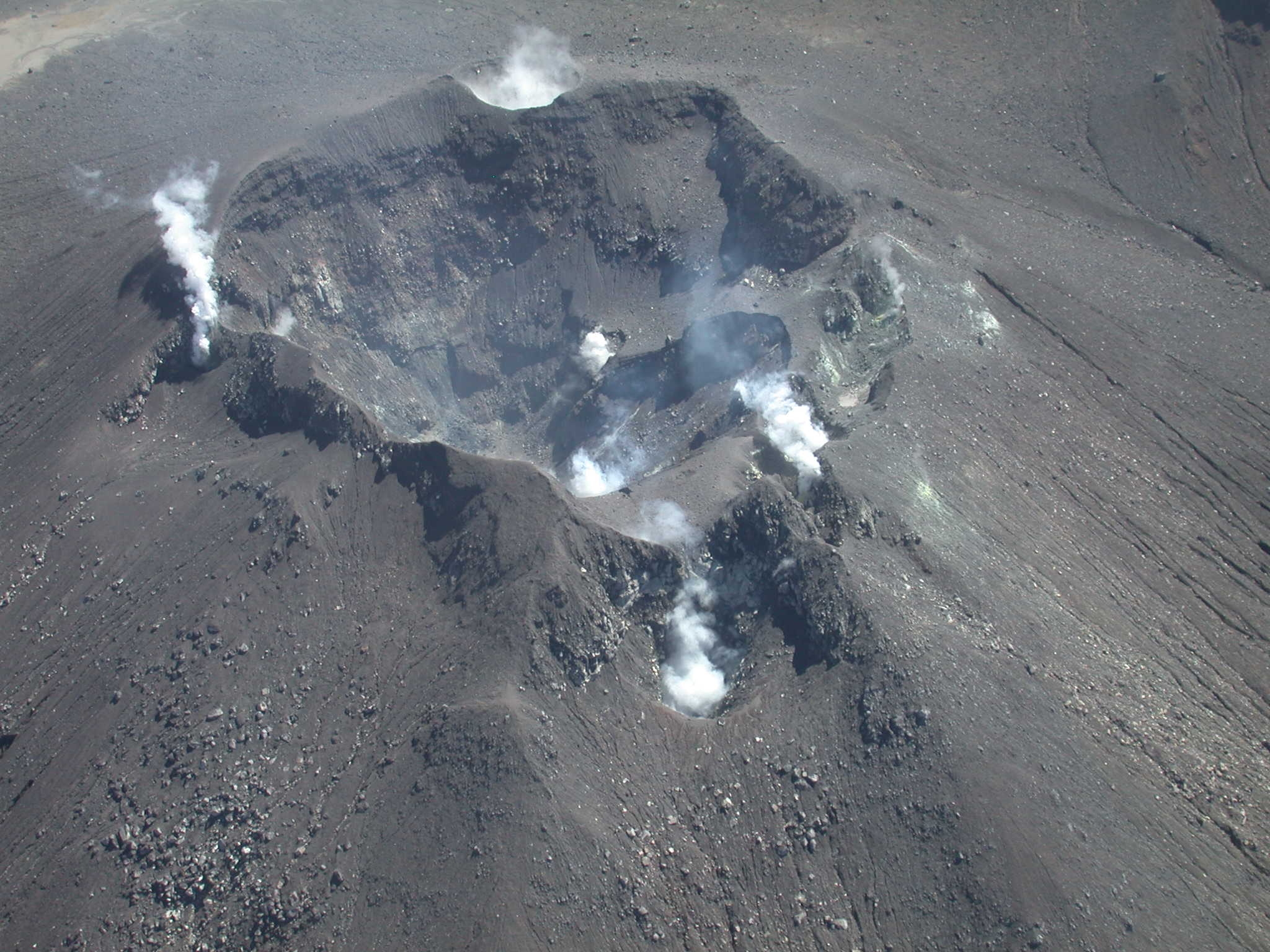
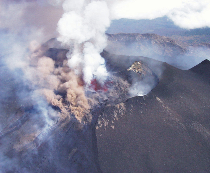
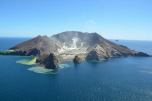
Aerial image of the active cone of the Galeras volcano. Craters and fumarole fields on the west side, September 28, 2005.
During the evaluated period, when climatic conditions in the volcano region allowed, it was possible to observe the gas emissions of the main fumarolic fields of the active cone, with a low outlet pressure, a white color, a low height and direction of dispersal according to the predominant direction of the winds in the volcanic peak region.
The other geophysical and geochemical parameters of the volcanic monitoring of Galeras do not allow to record variations that show a change in the level of activity of the volcano.
The COLOMBIAN GEOLOGICAL SERVICE remains attentive to the evolution of the volcanic phenomenon and will continue to inform in a timely manner of the observed changes
Source : SGC
Photo : SGC
Kamchatka , Ebeko :
VOLCANO OBSERVATORY NOTICE FOR AVIATION (VONA).
Issued: July 20 , 2018 .
Volcano:Ebeko (CAVW #290380)
Current aviation colour code: ORANGE
Previous aviation colour code:orange
Source:KVERT
Notice Number:2018-64
Volcano Location:N 50 deg 41 min E 156 deg 0 min
Area:Northern Kuriles, Russia
Summit Elevation:3791.68 ft (1156 m)
Volcanic Activity Summary:
According to satellite data, a moderate explosive activity of Ebeco volcano continues. Ash cloud drift to the north-east from the volcano.
A moderate gas-steam with some amount of ash activity of the volcano continues. Ash explosions up to 16,400 ft (5 km) a.s.l. could occur at any time. Ongoing activity could affect low-flying aircraft and airport of Severo-Kurilsk.
Volcanic cloud height:
8200 ft (2500 m) AMSL Time and method of ash plume/cloud height determination: 20180720/0045Z – MODIS TERRA (31m32)
Other volcanic cloud information:
Distance of ash plume/cloud of the volcano: 9 mi (15 km)
Direction of drift of ash plume/cloud of the volcano: E / azimuth 80 deg
Time and method of ash plume/cloud determination: 20180720/0045Z – MODIS TERRA (31m32)
Source : Kvert.
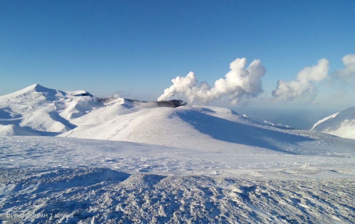
Photo : T. Kotenko, IVS FEB RAS , 12/1/2017
Hawaï , Kilauea :
Thursday, July 19, 2018, 12:27 PM HST (Thursday, July 19, 2018, 22:27 UTC)
19°25’16 » N 155°17’13 » W,
Summit Elevation 4091 ft (1247 m)
Current Volcano Alert Level: WARNING
Current Aviation Color Code: ORANGE
Kīlauea Volcano Lower East Rift Zone
Fissure 8 continues to erupt lava into the perched channel leading northeastward from the vent. Lava levels in the channel appeared a bit low this morning and there were no overflows noted. The southern margin of the flow is about 500 m (0.3 mi) from the boat ramp at Isaac Hale Park this morning. Despite no visible surface connection to the fissure 8 channel, lava continues to ooze out at a few points on the 6 km (3.7 mi) wide flow front into the ocean.
No other fissures are active this morning.
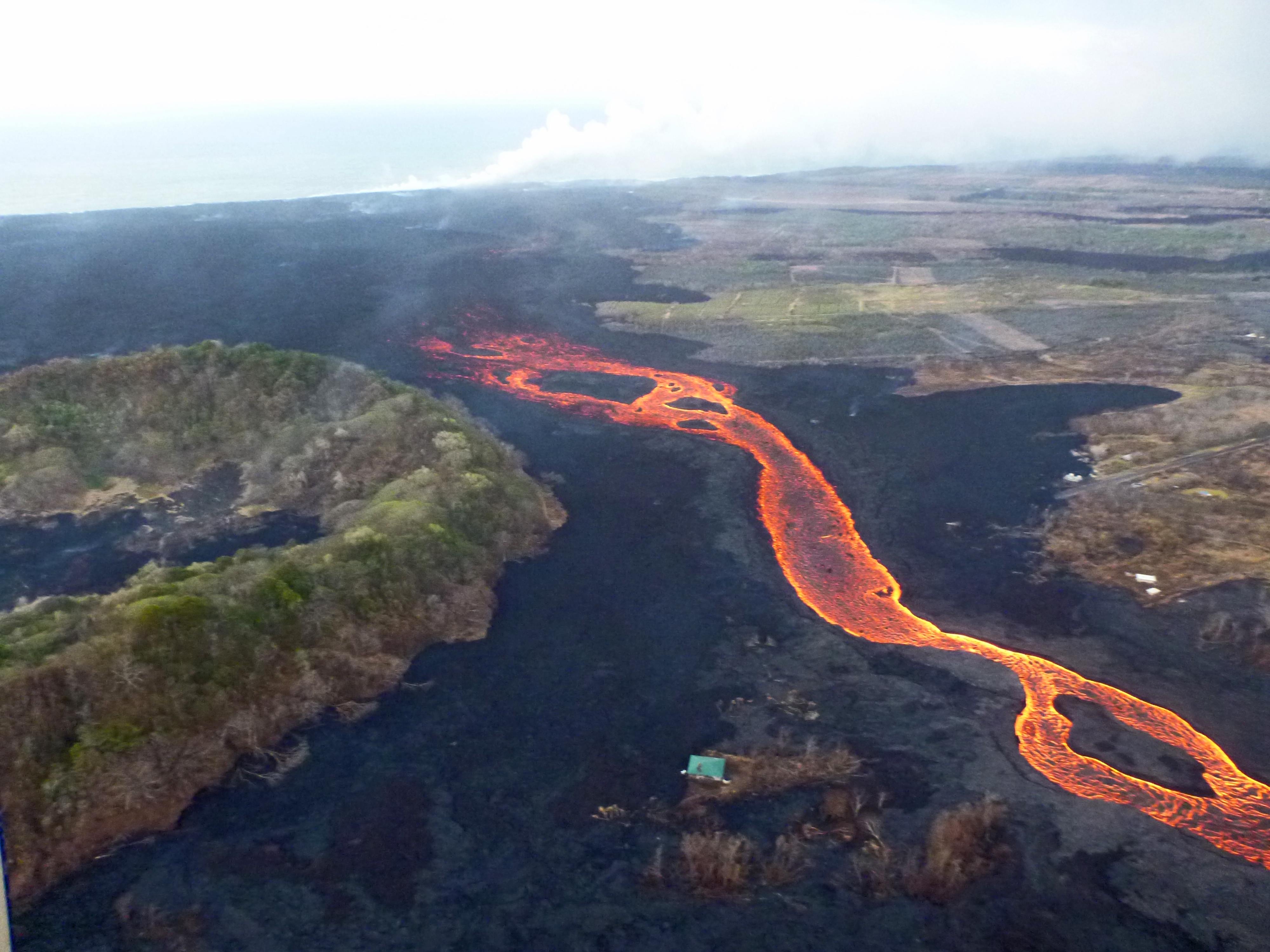
An aerial view looking south, with the fissure 8 lava channel on the west side of Kapoho Crater, visible at left. As it nears the ocean, the channelized lava transitions to a broad ‘a‘ā flow that spreads laterally and toward the coast. The ocean entry plume is barely visible in the far distance (top).
Kīlauea Volcano Summit
After the collapse event that occurred 1:28 a.m. HST July 18, seismicity at the summit decreased immediately following the event and is now back to 25-35 earthquake per hour leading up to the next collapse/explosion event, which is expected to occur this afternoon.
Source : HVO.
Italy , Etna :
The summit craters of Etna, the transformist volcano!
Etna is the highest active volcano in continental Europe (3324 m above sea level) and rises along the eastern coast of Sicily over an area of over 1250 km2. The volcano is defined as an « open conduit », that is to say that it has a central conduit that connects the interior of the Earth, from where the Etnaen magmas come, more than 30 km deep, with the surface of the Earth. This open channel allows the magma to rise continuously, releasing the volatile phases through the area of the summit craters from which emerges the characteristic gaseous plume observed every day at the top of Mount Etna.
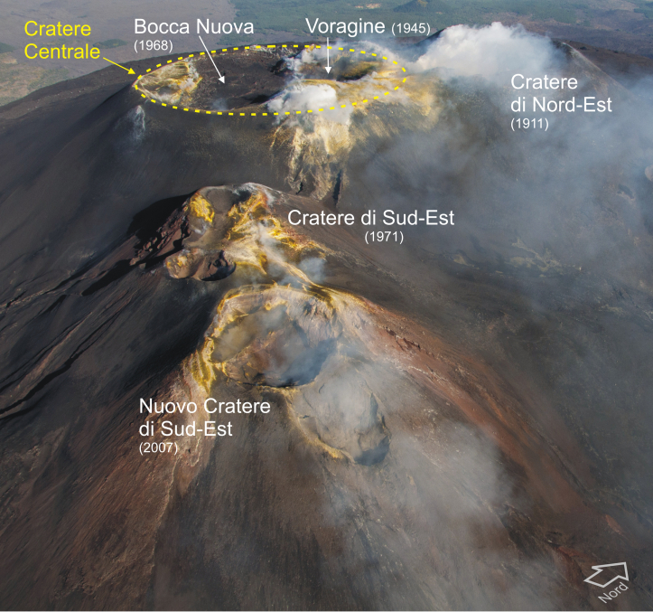
The area of the summit craters never stays the same over time, on the contrary, it changes continuously. Suffice it to say that only one hundred and twenty years ago, the summit of the volcano culminated with a single central crater, while today we find five, evidence of rapid and marked morpho-structural changes (Figure 1).
Figure 1 – Aerial photograph of the Etna summit crater area taken from the southeast. Next to the names of the five active craters, the year of their birth is indicated in parentheses. Photo: Marco Neri.
How is the summit of Etna arranged?
In the apical zone of the volcano, there are now five main eruptive devices that have formed and expanded in recent decades. Until the beginning of the 20th century, only the central crater was present at the top of Etna. In 1911, the Northeast crater was born on the northern flank of the central crater. Subsequently, Voragine (in 1945) and Bocca Nuova (in 1968) formed inside the central crater. In 1971, on the south-east side of the central crater, forms the South-East crater, which remains active until 2007. Then also began to develop the new crater of South-East, resting on the eastern flank of « Old » Southeast crater. Below, we try to summarize the eruptive history of these devices.
The central crater
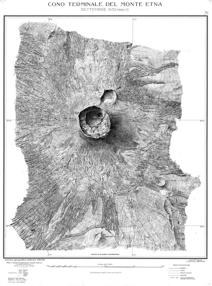
It is the only active mouth of the summit, which has existed for at least a century before 1911 (Figure 2). A large crater with a circular edge about 500 meters in diameter, certainly several tens of meters deep, perhaps inherited from the collapse of the crater that took place on Mount Etna during the violent eruption of 1669 which touched the entire southern flank of the volcano.
Figure 2 – Topographic maps published by the Military Geographical Institute updated until 1932. In the center of the map is the central crater, which is approached, just to the north, by the crater Northeast which began its activity in 1911.
The Northeast crater:
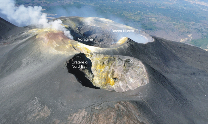
He was born in the spring of 1911, just north of the central crater (Figure 2). This crater becomes more active in 1917, when it feeds a brief episode of lava fountain (or paroxysm). Subsequently, its activity is, for the most part, frequent Strombolian explosions of modest energy, accompanied by lava emissions, which together determine, especially from 1955, the progressive growth of a massive pyroclastic cone. . From the summer of 1977, paroxysmal episodes became more frequent, producing eruptive columns up to 12 km high. Many of these paroxysms are accompanied by the emission of lava flows that reach maximum lengths of more than 6 km, as in March 1978. With the last series of paroxysms (between 1995 and 1998), the crater Northeast reaches its maximum size, which rises as the highest peak of the entire volcano (about 3330 meters above sea level, measured in 2008). Subsequently, its activity decreases considerably, being limited to weak Strombolian intra – crateric explosions. It was only during the December 2015 and May 2016 eruptions that the Northeast crater again shows a more intense Strombolian activity, which eventually causes almost total obstruction of the crater and the collapse of its southern border. Finally, in November 2017, the bottom of the Northeast crater sinks and opens, allowing to emit the gaseous plume that characterizes it. Today, the Northeast crater continues to be, albeit slightly, the highest point in Etna (3324 m above sea level, measured in December 2015, Figure 3).
Figure 3 – Panoramic view of Mount Etna from the North, July 2017. In the foreground, the Northeast Crater, whose Southwest edge is the highest point of the volcano. Photo: Marco Neri.
The Voragine:
The crater of Voragine was born in the autumn of 1945 in the central crater and precisely in its north-east part. This crater is less active than the other summit craters, but has produced some of the most violent paroxysms in the recent history of Etna. The strongest of these paroxysms (1960, 1998, 1999, 2015) produce high eruptive columns up to 15 km. The last eruptions of Voragine, very explosive, take place in the first days of December 2015 (Figure 4) and in May 2016. The products of these eruptions are dumped in the neighboring Bocca Nuova then overflow, pouring on the top of the West flank of the volcano. On August 7, 2016, near the North-East limit of Voragine, a degassing mouth opens, still active today. In the first few months, this new mouth of Voragine is characterized by the emission of very hot gas (> 700 ° C), whose temperature drop coincides with the « reopening » of the Crater Northeast in November 2017.
Figure 4 – Paroxysmal eruptive activity of the crater of Voragine, December 2015, taken from the West. Photo by Veronica Testa.
The Bocca Nuova:
This crater was born in the spring of 1968 on the west flank of the central crater. Until mid-1997, the Nuova Bocca is mainly characterized by crater collapse phenomena and from time to time, a Strombolian activity that is modest and effusive intra-craterically, which cause the progressive widening of the crater until at a maximum diameter of more than 350 m. During the years 1997-1999, an intense intra-crater eruptive activity causes the progressive filling of the Bocca Nuova, which culminates then in a violent eruption in October-November 1999 (figure 5). After a new phase of subsidence and deepening of the crater, from 2011, the Bocca Nuova returns to a strombolian and expansive intra-crater production, but modest. The strong eruptions of its neighbor Voragine of December 2015 and May 2016 unload a large part of their products inside the Bocca Nuova, filling it to the brim and obstructing its bottom. From October 2016, the bottom of this crater deepens and opens. Today most of Etna’s gas plume is produced by Bocca Nuova gas.
Figure 5 – Strombolian violent activity of the Bocca Nuova Crater taken from the West, October 1999. The eruptive phenomenon is accompanied by an abundant flow of lava on the western edge. Photo by Marco Neri.
The Southeast crater and the new Southeast crater:
As in the cases previously illustrated, the Southeast crater also begins its activity with the formation of a small mouth that opens during the eruption of 1971, located on the southeast side of the central crater. Subsequently, between 1978 and 1979, the Southeast Crater produced short paroxysmal episodes and modest lava effusions. This eruptive style continues over the next two decades, with lava fountains forming eruptive columns several kilometers high and the emission of large lava flows (in 1980, 1985, 1986, 1989, 1998-1999), interspersed with Strombolian activity that persists for several months (1984, 1996-1998). Since 2000, it has significantly increased the frequency of its eruptions (66 lava fountains and lava flows between January and August 2000, 16 between May and July 2001, 20 in 2006, 4 in spring 2007), which determine the rapid growth of the system. eruptive. After 4 paroxysms from March to May 2007, the eruptive activity moves from the top of the cone to a new mouth that opens on its lower East side, which produces three violent paroxysms between September 2007 and May 2008. After a lull of about one half-year, in January 2011, this new mouth produces an additional lava fountain, followed by dozens of other strombolian and paroxysmal episodes that determine the rapid growth of a massive new pyroclastic cone called the new southeastern crater (Figure 6 and 7). In just four or five years, this new summit crater reaches the same dimensions as the « old » Southeast crater over the last forty years. Since the end of 2013, the activity of the new crater of the Southeast has become less violent and frequent.
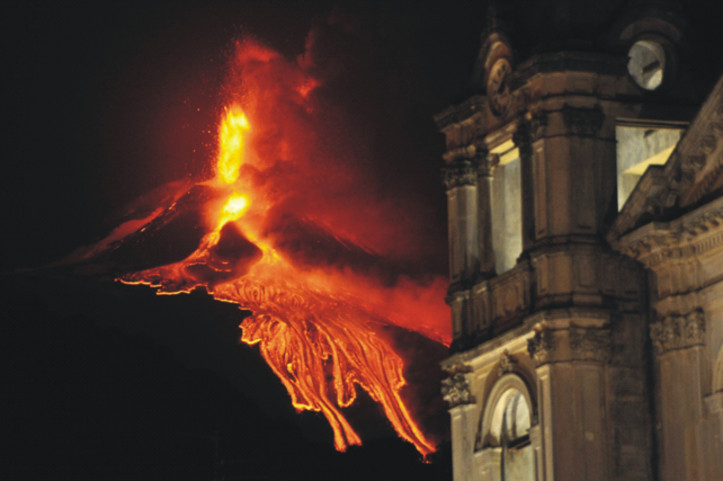
Figure 6 – Strombolian and effusive eruptive activity of the New Southeast Crater, taken from Zafferana Etnea. On the right, the bell tower of the church Santa Maria della Provvidenza. Photo by Marco Neri.
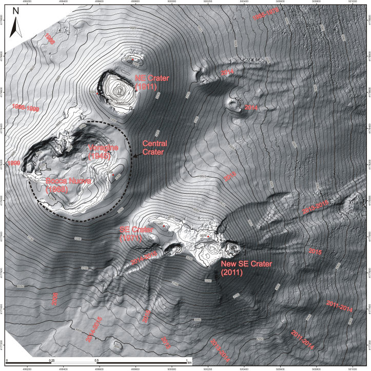
Figure 7 – Topographic map of the Etna summit updated in December 2015, recently published in the Journal of Maps (Neri et al., 2017, Taylor & Francis Group, doi: 10.1080 / 17445647.2017.1352041) and downloadable for free via the Internet portal of the same magazine.
Source : Dr. Marco Neri ( https://ingvvulcani.wordpress.com/2018/07/19/i-crateri-sommitali-delletna/ ).
Mexico, Popocatepetl :
July 19, 11:15 am (July 19, 16:15 GMT)
In the past 24 hours, with the monitoring systems of the Popocatepetl volcano, 51 low intensity exhalations accompanied by water vapor and gas were identified, as well as an explosion at 08:31 h. In addition, two volcano-tectonic earthquakes recorded yesterday at 22:25 h and 5:39 h today, with an amplitude of M1,8 and M2,6 respectively were detected. In addition, 28 minutes of harmonic tremor of low amplitude were recorded.
During the night we observed an incandescence which increased at the time of the emissions.
At the time of this report, there is visibility of the volcano, the emission of water vapor and gas has a west direction.
CENAPRED asked not to approach the volcano and in particular the crater, because of the risk of falling of projectiles, and in case of heavy rain, to stay far from the bottoms of the ravines because of the danger of landslides and flows mud.
The Popocatepetl volcanic warning light is located at Amarillo Phase 2.
July 19, 23:00 (July 20, 4:00 GMT)
From 9:30 pm, a sequence of small explosions accompanied by light ash emissions to the west appeared on the volcano.
The foregoing is envisaged in the predicted scenarios and does not imply for the moment any change in the level of volcanic warning of the volcano Popocatépetl
The Popocatepetl volcanic warning light is located at Amarillo Phase 2.
Source : Cenapred.

