June 19 , 2018.
Pu’u ‘Ō’ō / Kilauea , Hawai :
Sunday, June 17, 2018, 10:28 PM HST (Monday, June 18, 2018, 08:28 UTC)
19°25’16 » N 155°17’13 » W,
Summit Elevation 4091 ft (1247 m)
Current Volcano Alert Level: WARNING
Current Aviation Color Code: RED
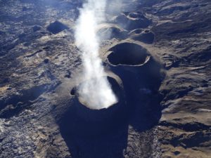
Kīlauea Volcano Lower East Rift Zone
The Lower East Rift Zone (LERZ) eruption in Leilani Estates continues with little change.
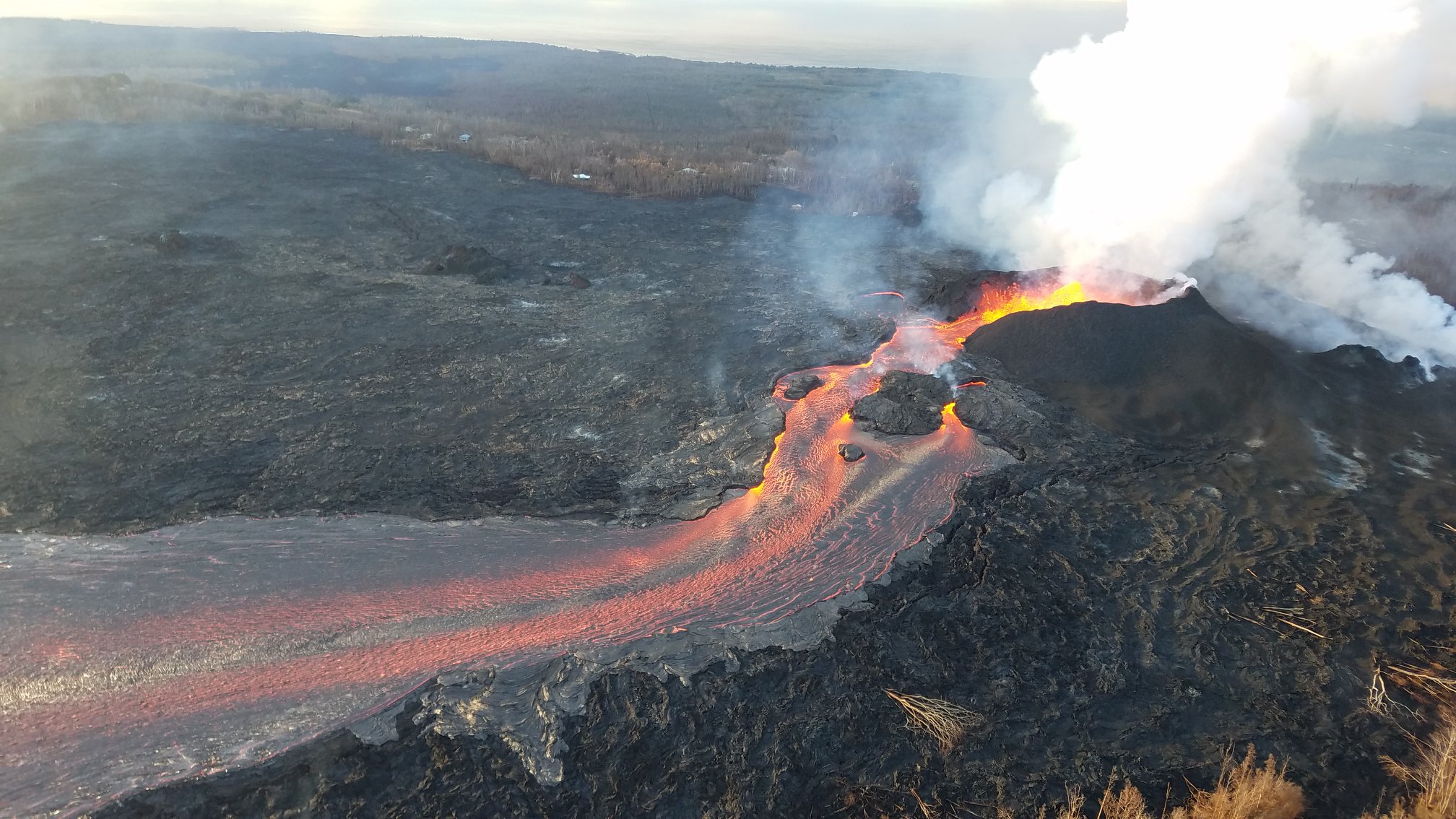
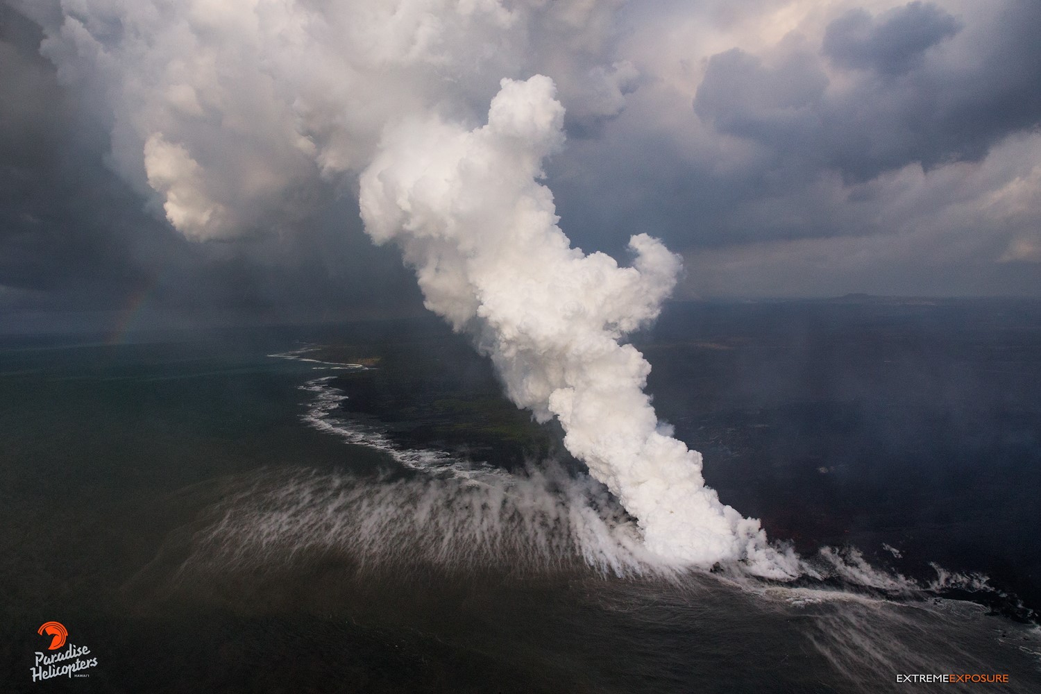
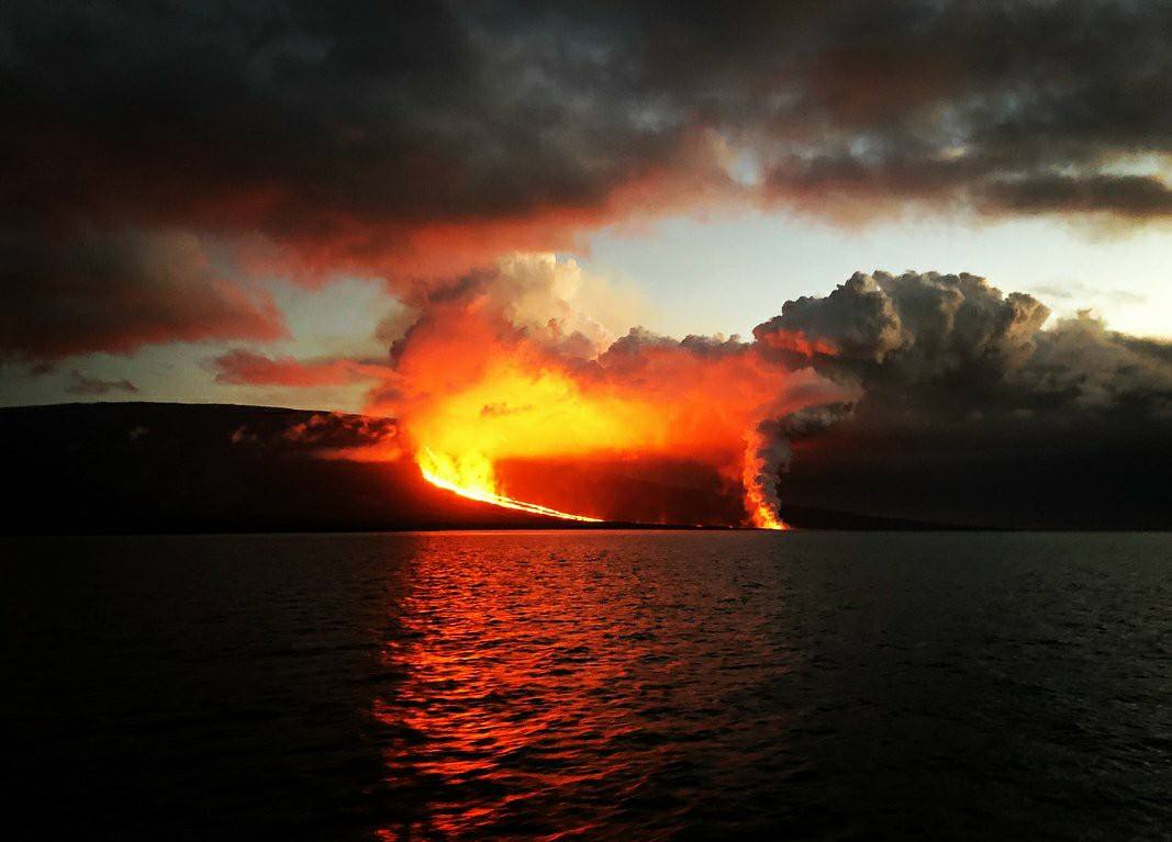
Fountains ranging between 60 – 165 ft from the Fissure 8 spatter cone continue to feed lava into the well-established channel that flows to the ocean at Kapoho. Occasionally, minor amounts of lava briefly spill over the channel levees. The ocean entry remained fairly broad with laze blown onshore. Fissures 16/18 continue to ooze lava. Incandescence (visible in PGcam to the left of fissure 8 most nights) and mild spattering were observed from Fissure 6. The flow field is relatively stable with little change to its size and shape for the past few days.
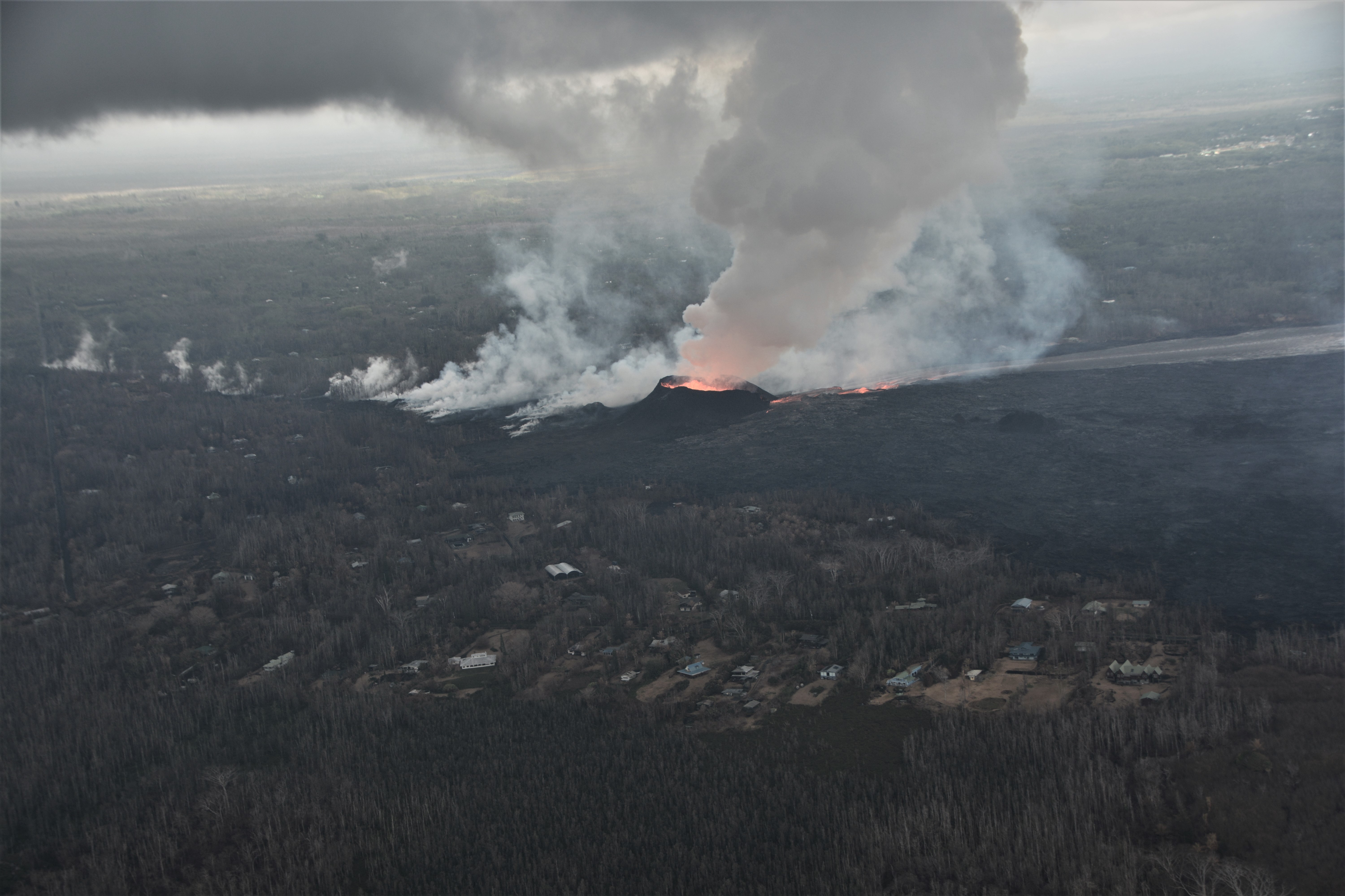
Morning overflight of Kīlauea Volcano’s lower East Rift Zone by the Civil Air Patrol provides context for the location of the fissure 8 fountain and lava channel within the lower Puna District. View is to the north. Image courtesy of Civil Air Patrol.
Pele’s hair and other lightweight volcanic glass fragments from the lava fountain at Fissure 8 continue to fall downwind of the fissure, dusting the ground within a few hundred meters (yards) of the vent. High winds may waft lighter particles to greater distances. Residents are urged to minimize exposure to these volcanic particles, which can cause skin and eye irritation similar to volcanic ash.
HVO field crews are on site tracking the fountains, lava flows, and spattering from Fissure 8 as conditions allow and are reporting information to Hawaii County Civil Defense. Observations are also collected on a daily basis from cracks in the area of Highway 130; no changes in temperature, crack width, or gas emissions have been noted for several days.
https://www.facebook.com/contactjoeanthony/videos/10156128373975622/
Volcanic gas emissions remain very high from Fissure 8 eruptions. Winds are expected to bring VOG to the central, south, and western parts of the Island of Hawaii.
Magma continues to be supplied to the Lower East Rift Zone. Seismicity remains relatively low in the area with numerous small magnitude earthquakes and low amplitude background tremor. Higher amplitude tremor is occasionally being recorded on seismic stations close to the ocean entry.
Kīlauea Volcano Summit
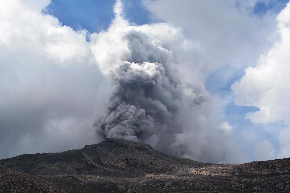
Inward slumping of the rim and walls of Halemaʻumaʻu continues in response to ongoing subsidence at the summit. After the explosive collapse at 6:26 AM HST this morning, seismicity at Kīlauea’s summit gradually increased reaching 30-35 events per hour by 10 PM HST this evening. If the pattern of the last several days holds, another explosive collapse could occur within the next 12 hours or so.
Sulfur dioxide emissions from the volcano’s summit have dropped to levels that are about half those measured prior to the onset of the current episode of eruptive activity. This gas and minor amounts of ash are being transported downwind, with small bursts of ash and gas accompanying intermittent explosive activity.
Monday, June 18, 2018, 9:24 AM HST (Monday, June 18, 2018, 19:24 UTC)
Volcan Kīlauea , Lower East Rift Zone:
The eruption from vents in the lower East Rift Zone (LERZ) continues with little change.
Fissure 8 fountains, encircled by a spatter cone, continue to feed lava into the well-established channel that flows to the ocean at Kapoho. Occasionally, minor amounts of lava briefly spill over the channel levees. The lava flow is rather broad at the coast and lava is entering the ocean at a single point with an upwelling area offshore and with laze blown onshore. Fissures 16/18 continue to ooze lava and Fissure 6 shows some incandescence (visible in PGcam to the left of Fissure 8 most nights) and mild spattering during our overflights. The flow field is relatively stable with little change to its size and shape for the past few days.
Kīlauea Volcano Summit
After over 500 earthquakes (24 of which were strong than magnitude-3.0) since noon Sunday beneath the summit of Kīlauea volcano, nearby residents felt a large earthquake and may have heard a roaring followed by a low gas plume emerging from Halema`uma`u crater at 6:13 AM HST. The plume was blown downwind at about 1,000 ft above ground level. Seismicity abruptly dropped as it commonly does after these events and we expect it to begin increasing during the day. Inward slumping of the rim and walls of Halemaʻumaʻu continues in response to ongoing subsidence at the summit.
Monday, June 18, 2018, 3:45 PM HST (Tuesday, June 19, 2018, 01:45 UTC)
Kīlauea Volcano Lower East Rift Zone
The eruption from vents in the lower East Rift Zone (LERZ) continues with little change.
https://www.facebook.com/harry.durgin.1/videos/10156369308534242/
Fissure 8 fountains, encircled by a spatter cone, continue to feed lava into the well-established channel that flows to the ocean at Kapoho. About midday, minor amounts of lava spilled over the channel levees but did not advance very far. The lava flow front is rather broad at the coast and lava is entering the ocean at a single point with an upwelling area offshore and with laze blown onshore. Fissures 16/18 continue to ooze lava and Fissure 6 shows some incandescence (visible in PGcam to the left of Fissure 8 most nights) and mild spattering. The flow field is relatively stable with little change to its size and shape for the past few days.
Kīlauea Volcano Summit
After this morning’s seismic event and gas emission, the number of earthquakes dropped abruptly and have been increasing through the day. Inward slumping of the rim and walls of Halemaʻumaʻu continues in response to ongoing subsidence at the summit.
Source : HVO.
Photos : USGS, Bruce Omori.
Videos : Joseph Anthony , Harry Durgin .
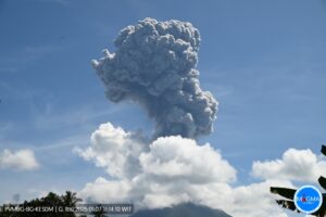
Fernandina , Galapagos , Ecuador :
Special Report of the Fernandina Volcano N ° 5 – 2018
Decrease in eruptive activity
Summary:
After two days of intense eruptive activity on the Fernandina volcano (Special Report No. 4), a clear decrease is recorded for the moment. As the seismic level, tremor decreased significantly from what was observed on June 16 when the greatest seismic activity was recorded. A peak of caloric energy was also recorded on June 16 at 22:25 Galapagos time (TG = Ecuador time -1h), and from there, the thermal anomalies identified in the satellite images decreased.
The satellite images also show that the concentrations of sulfur dioxide (SO2) emitted by the volcano have decreased considerably. All this information indicates that the eruptive process is diminishing and could end in the next hours or days. However, it is important to note that on previous occasions (Fernandina 2009, Wolf 2015) the eruption stopped momentarily and then restarted. For this reason, it is recommended to stay away from the eruption site and in particular the entry of lava into the sea. The IGEPN continues volcanic monitoring and will inform if changes in internal activity or external of the volcano are observed.
Seismicity:
The RMS graph (indicator for observing the amplitude of the seismic signal) shows a rapid increase following the seismic swarm of June 16, 2018 (Special Report No. 1), reaching a maximum at 09:22 am, approximately 90 minutes before the seismic swarm. beginning of the eruption (Figure 1). Then a second increase was observed associated with eruption tremor with maximum amplitude about 1 hour after the onset of eruption. From this moment, a gradual decrease of the RMS values is observed reaching almost the pre-eruptive level, at the time of publication of this report.
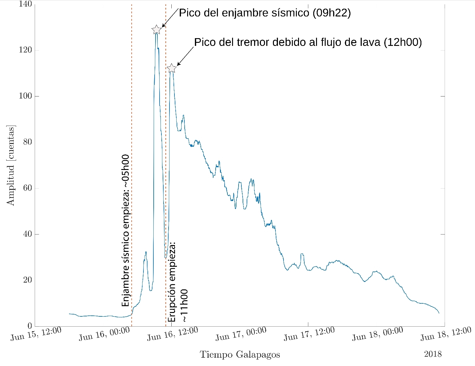
Figure 1. RMS of the seismic signal of the FER-2 station (Source: Stephen Hernandez, IGEPN).
Thermal anomalies:
From the beginning of the eruption, thermal anomalies were reported by the FIRMS and MIROVA systems. On MIROVA, the thermal energy peak was observed on June 16 at 22:25 TG with an extremely high thermal anomaly reaching 11.6 GW (Figure 2). On FIRMS, it is clearly observed that the alerts are located on the North-North-East flank of the volcano (Figure 3). The intensity of the thermal anomalies detected on the Fernandina volcano remains very high.
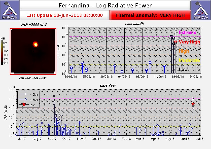
Figure 2. Thermal anomaly record of the Fernandina volcano (source: MIROVA). Thermal anomalies can also be associated with fires and non-volcanic sources. Thermal anomalies can be masked or attenuated by clouds.
Figure 3. Location of thermal warnings on the North-North-East flank of Fernandina volcano (source: FIRMS). The area that records heat alerts may be wider than the area of the blowout due to the resolution of the satellite instrument.
Clouds of gas:
On June 17, a cloud of SO2 gas of more than 500 km was observed, directed towards the West (Figure 4 on the left). On June 18, the gas cloud is even larger (reaching more than 1000 km long) but with a much lower concentration of SO2 (Figure 4 right). In addition, the June 18 cloud of gas appears slightly separated from the Galapagos Islands, which could indicate that the volcano no longer emits large amounts of gas at the time of publication of this report.
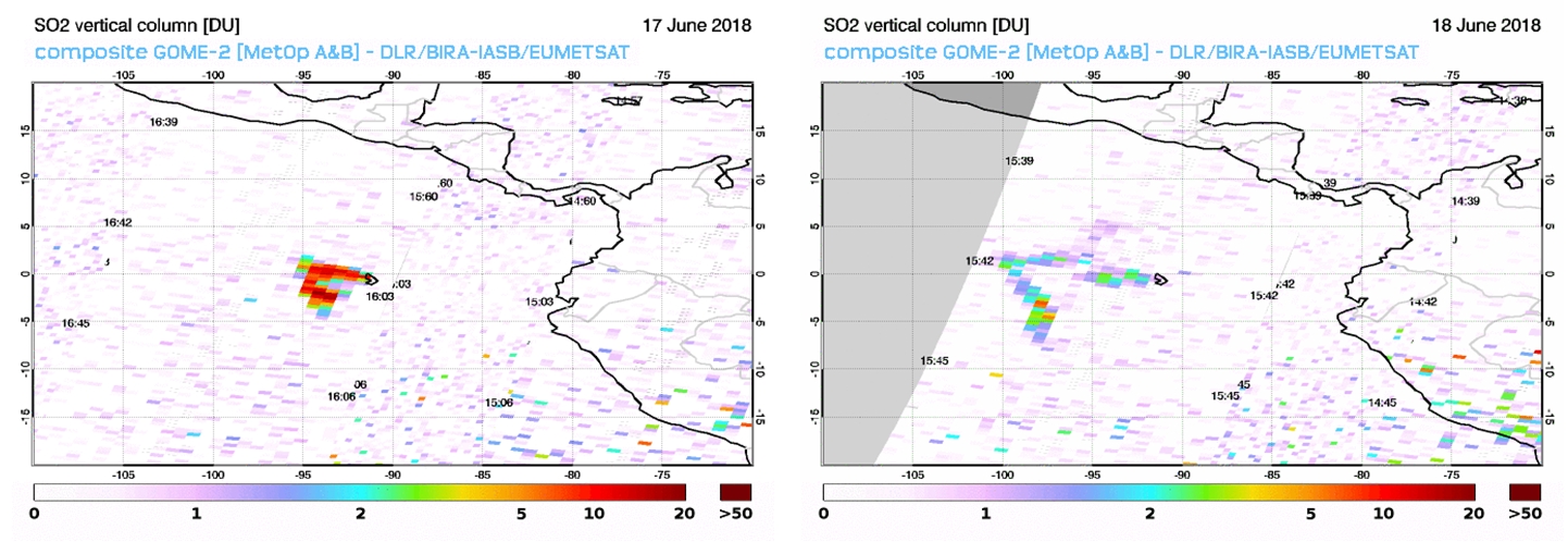
Figure 4. SO2 gas anomalies detected by the GOME-2 satellite on June 17 (left) and June 18 (right) in June 2018 (source: ESA).
Interpretation:
The three monitoring systems (seismic, thermal, gas) used to monitor the eruption of Fernandina clearly show that the eruptive activity decreases and could end in the next hours or days. On two occasions in the Galapagos, a drop in activity was observed a few days before a new increase associated (Wolf 2015) or not (Fernandina 2009) to a change of the site of the eruption. Therefore, it is important to be aware of any changes in internal and superficial activity.
Recommendations:
It should be noted that there are no human settlements in the eruption area and that the wind direction carries the gas to the west, on the opposite side of the populated islands (Isabela, Santa Cruz, Floreana and San Cristóbal). It is recommended to stay away from the eruption and especially the entry of the lava into the sea as explosions can occur when the lava comes in contact with the water. This phenomenon produces a large amount of toxic gas. In addition, lava flows can cause fires.
The IGEPN continues volcanic monitoring and will inform if changes in the internal or external activity of the volcano are observed.
Source : IGEPN
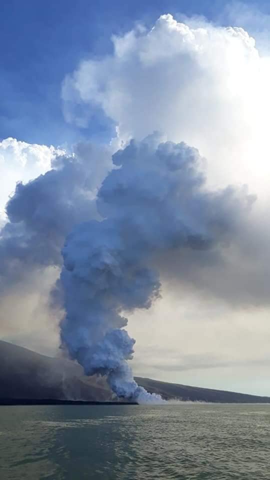
Photo : Galapagos Travel
Fuego , Guatemala :
SPECIAL BEFGO VULCANOLOGICAL BULLETIN # 81-2018 . Descent of lahars in the ravine LAS LAJAS. Guatemala 18 June 2018, 16.00 (local time)
Type of activity: Vulcanian
Morphology: Composite Stratovolcan
Location: 14 ° 28’54˝ Latitude N; 90 ° 52’54˝ Longitude W.
Height: 3,763msnm.
https://www.facebook.com/elclimaenguatemala.pronostico/videos/1717381531709502/
Due to constant rains in the Fuego Volcano region and the abundant accumulation of materials from the recent eruption, the descent of lahar into the Las Lajas Canyon is recorded at this time. Its dimensions are approximately between 40 and 45 meters wide and 2 meters high.
These lahars cause vibrations on their way, they contain a fine and pasty material abundant, blocks up to 3 meters in diameter, resulting in trunks and branches of trees in their path. Because of the last rash, they go down hot, feeling the smell of sulfur and steam emanating from it because of their temperature.
Due to the large amount of material that is still deposited in this region, the lahars with these characteristics will continue to be present.
Due to the rains that occur in the afternoon and evening, the probability of lahars occurring in one of the main ravines persists.
Source : Insivumeh
Vidéo : Meterologia GT
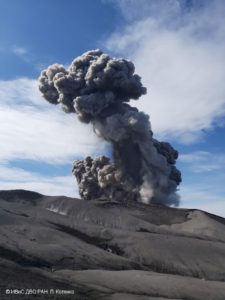
Sabancaya , Peru :
An average of 19 EXP / day was recorded. The earthquakes associated with the rise of the magma (type Hybrids) remain very weak in number and energy.
The eruptive columns of gas and ash reached a maximum height of 1400 m above the crater. The dispersion of these materials occurred within a radius of about 30 km, mainly in the south and south-east directions.
The volcanic gas flow (SO2) recorded on June 14 has a maximum value of 4300 tons / day, a value considered hight .
The deformation of the surface of the volcanic building does not present any significant variations.
Two thermal anomalies were recorded according to the MIROVA system, with values ranging between 1 MW and 13 MW VRP (Radiated Volcano Power).
In general, eruptive activity maintains moderate levels. No significant changes are expected in the coming days.
Source : IGP