June 15 , 2018.
Pu’u ‘Ō’ō / Kilauea , Hawai :
Wednesday, June 13, 2018, 10:21 PM HST (Thursday, June 14, 2018, 08:21 UTC)
19°25’16 » N 155°17’13 » W,
Summit Elevation 4091 ft (1247 m)
Current Volcano Alert Level: WARNING
Current Aviation Color Code: RED
Kīlauea Volcano Lower East Rift Zone
The eruption of lava continues from the lower East Rift Zone (LERZ) in Leilani Estates with little change over the past few days.
Lava fountains reaching heights of 53 m (174 ft) were observed at Fissure 8 in the late afternoon. Lava from Fissure 8 continues to flow through the well-established channel to the ocean at Kapoho, with rare, small overflows of the channel levees. A laze plume at the ocean entry was blown onshore this afternoon, and areas of upwelling offshore were present throughout the day. Fissures 16 and 18 continue to ooze lava.
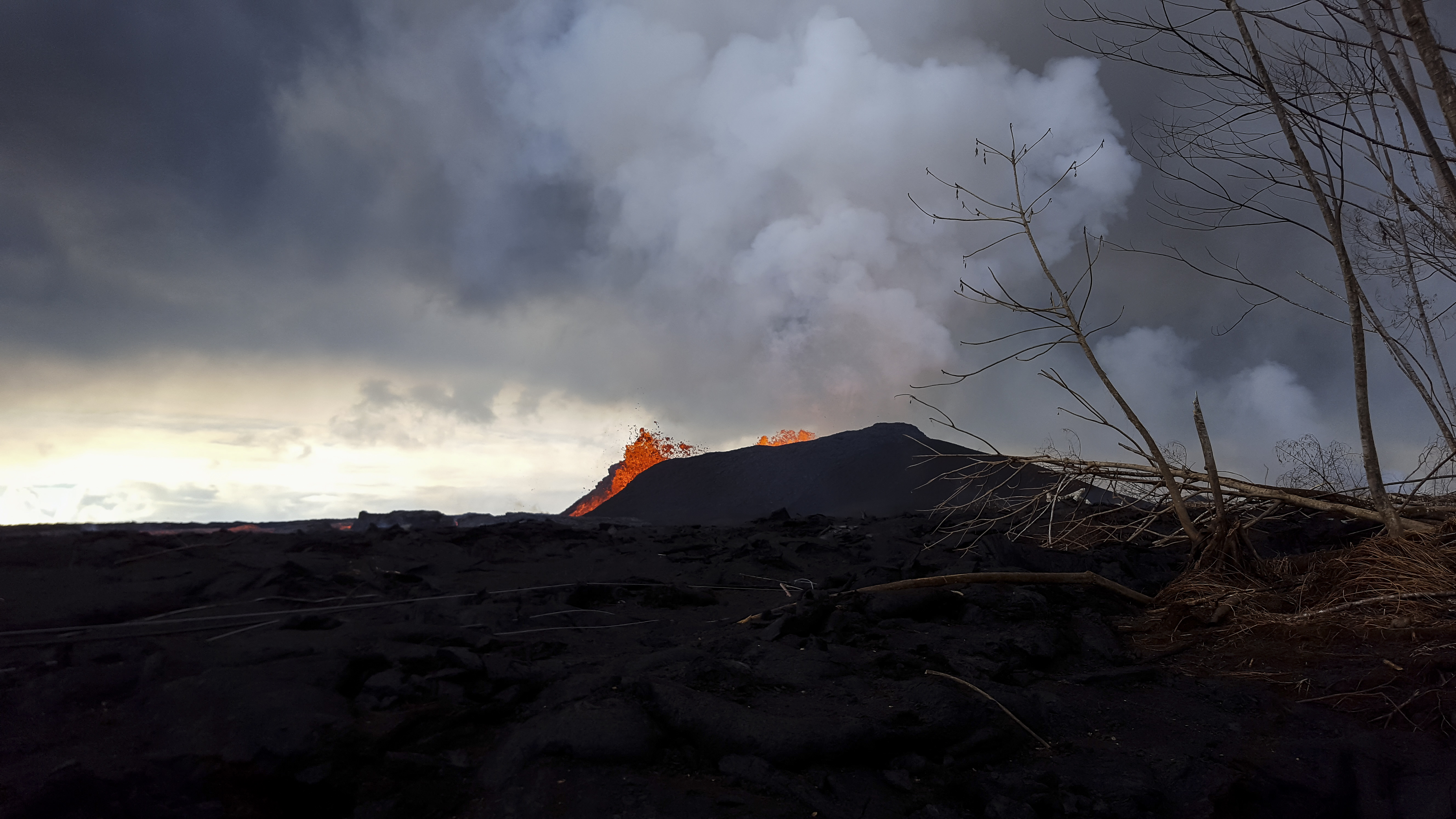
Fissure 8 lava fountains continue to reach heights of 40-45 m (130-150 ft) from within the growing cone of cinder and spatter, which is now about 40 m (130 ft) at its highest point. Fountaining at fissure 8 continues to feed the fast-moving channelized flow that is entering the ocean at Kapoho.
Pele’s hair and other lightweight volcanic glass fragments from the lava fountain at Fissure 8 continue to fall downwind of the fissure, dusting the ground within a few hundred meters (yards) of the vent.. High winds may waft lighter particles to greater distances. Residents are urged to minimize exposure to these volcanic particles, which can cause skin and eye irritation similar to volcanic ash.
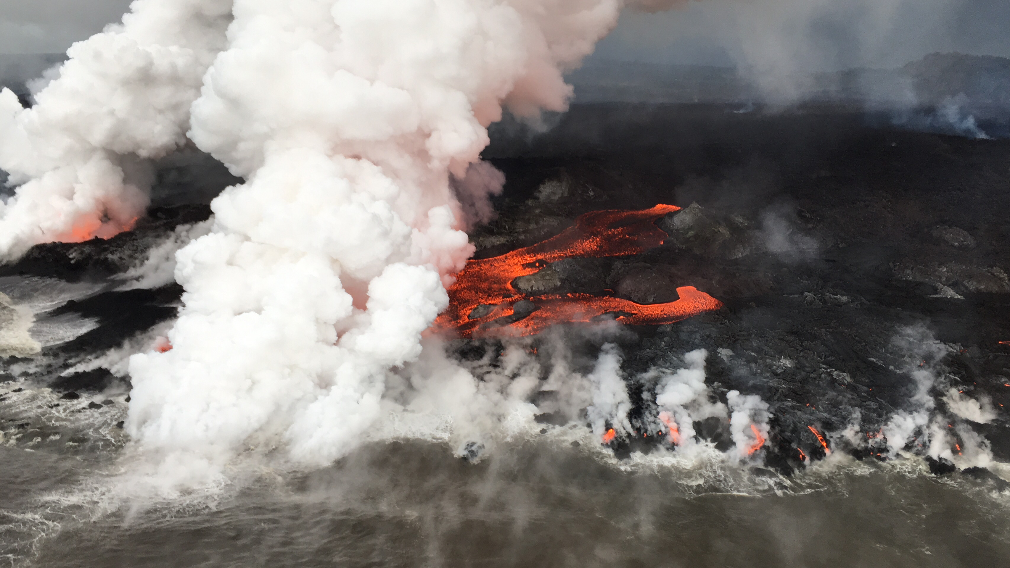
A close up view of the pāhoehoe breakouts along the northern ocean entry.
HVO field crews are on site tracking the fountains, lava flows, and spattering from Fissure 8 as conditions allow and are reporting information to Hawaii County Civil Defense. Observations are also collected on a daily basis from cracks in the area of Highway 130; no changes in temperature, crack width, or gas emissions have been noted for several days.
Volcanic gas emissions remain very high from Fissure 8 eruptions. Gas emissions have increased over the past two weeks.
Kīlauea Volcano Summit
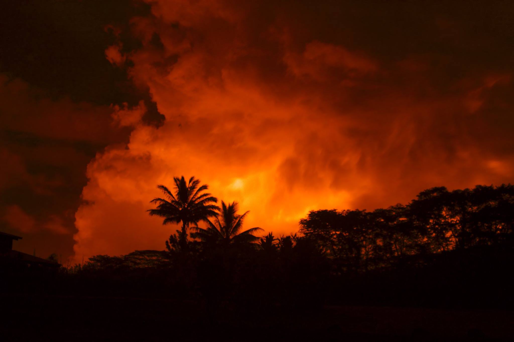
Following this morning’s small explosion at Kīlauea’s summit, earthquake activity returned to low levels for much of the day, but began a steady increase by this late afternoon. Inward slumping of the rim and walls of Halema`uma`u continues in response to ongoing subsidence at the summit.
Sulfur dioxide emissions from the volcano’s summit have dropped to levels that are about half those measured prior to the onset of the current episode of eruptive activity. This gas and minor amounts of ash are being transported downwind, with small bursts of ash and gas accompanying intermittent explosive activity.
https://www.facebook.com/contactjoeanthony/videos/10156117258300622/
Thursday, June 14, 2018, 9:41 AM HST (Thursday, June 14, 2018, 19:41 UTC)
Kīlauea Volcano Lower East Rift Zone
The eruption of lava continues from the lower East Rift Zone (LERZ) in Leilani Estates with little change over the past few days.
Fissure 8 lava fountains were observed reaching heights of 200 ft from within the growing cone of cinder and spatter, which is now about 160 ft at its highest point. Lava from Fissure 8 continues to flow through the well-established channel to the ocean at Kapoho, with rare, small overflows of the channel levees. A morning overflight confirmed that activity at the vent and channel continued with no significant changes. The ocean entry remained fairly broad with one main entry and several minor ones. A laze plume at the ocean entry was blown onshore this morning, and areas of upwelling offshore were present. Fissures 16 and 18 continue to ooze lava.
June 13, 2018 Rivers of Lava FB from Mick Kalber on Vimeo.
Kīlauea Volcano Summit
At 3:19 AM HST, another small explosion occurred at Kīlauea’s summit, producing a plume which rose to 6,000 ft above sea level. This event and many of its precursory earthquakes were felt widely in the Volcano area. Inward slumping of the rim and walls of Halema`uma`u continues in response to ongoing subsidence at the summit.
Thursday, June 14, 2018, 4:14 PM HST (Friday, June 15, 2018, 02:14 UTC)
Kīlauea Volcano Lower East Rift Zone
The eruption of lava continues from the lower East Rift Zone (LERZ) in Leilani Estates with little change over the past few days.
Fissure 8 lava fountains continue to reach heights of 200 ft from within the growing cone of cinder and spatter, which is now about 160 ft at its highest point. Lava from Fissure 8 continues to flow through the well-established channel to the ocean at Kapoho, with rare, small overflows of the channel levees. An early afternoon overflight confirmed that activity at the vent and channel continued with no significant changes. The ocean entry remained fairly broad with one main entry and several minor ones. A laze plume at the ocean entry was blown onshore this morning, and areas of upwelling offshore were present. Fissures 16 and 18 continue to ooze lava.
Kīlauea Volcano Summit
After this morning’s small explosion at Kīlauea’s summit, seismicity levels immediately dropped but started to increase during the day. Inward slumping of the rim and walls of Halema`uma`u continues in response to ongoing subsidence at the summit.
Sulfur dioxide emissions from the volcano’s summit have dropped to levels that are about half those measured prior to the onset of the current episode of eruptive activity. This gas and minor amounts of ash are being transported downwind, with small bursts of ash and gas accompanying intermittent explosive activity.
Source : HVO
Photos : USGS , Rod Miller.
Vidéos : Joseph Anthony , Mick Kalber.
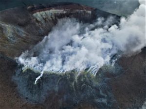
Galeras , Colombia :
Subject: Galeras Volcano Extraordinary Activity Bulletin
The level of activity of the volcano continues at the level:
YELLOW LEVEL ■ (III): CHANGES IN THE CONDUCT OF VOLCANIC ACTIVITY.
Following the activity of the GALERAS volcano, the COLOMBIAN GEOLOGICAL SERVICE informs that:
Supplementing the information provided in the special bulletin issued at 23:35 on 12 June, the following aspects are highlighted:
After the Volcano-Tectonic earthquake that occurred yesterday morning, June 12, 2018 at 4:35, magnitude 4.5 and up to the time of sending this bulletin, 550 earthquakes were recorded, of which 12 were reported as being felt by the inhabitants of the area of influence of the volcanic complex of Galeras, the last corresponding to the earthquake recorded today at 1:19 pm, with a magnitude of 2.8 on the Richter scale.
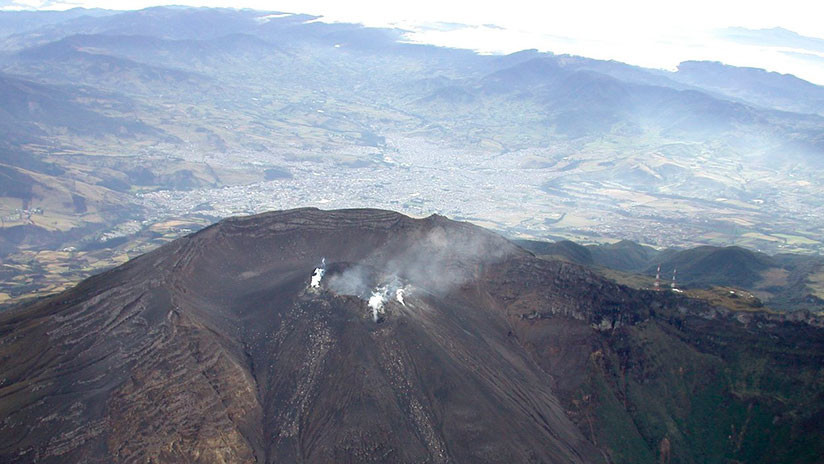
This seismic activity continues to be located in an area north of Galeras Volcano at distances of between 1.0 km and 8.0 km and depths of up to 8 km from the summit (reference level 4200m).
It is recalled that the seismicity that has been recorded since the end of May and especially since yesterday’s dawn, is located in an active zone where tectonically geological faults coexist with the structure of the volcanic complex of Galeras, therefore, the name of this type of earthquake is considered Volcano-Tectonic.
It is pointed out that the other geophysical and geochemical monitoring parameters of the Galerasne volcano show no significant changes. It was therefore maintained at the yellow or III activity level, which has not changed since about 7 years ago.
the COLOMBIAN GEOLOGICAL SERVICE continues to monitor the evolution of the volcanic phenomenon and will continue to report in a timely manner all observed changes.
Source : Ingeominas
Photo : Ingeominas/Handout
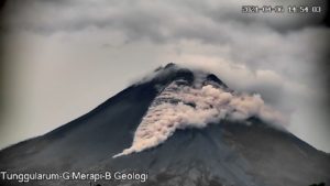
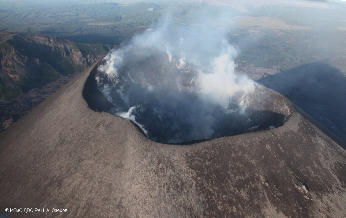
Karymsky , Kamchatka :
VOLCANO OBSERVATORY NOTICE FOR AVIATION (VONA).
Issued: June 14 , 2018
Volcano:Karymsky (CAVW #300130)
Current aviation colour code:YELLOW
Previous aviation colour code:orange
Source:KVERT
Notice Number:2018-50
Volcano Location:N 54 deg 2 min E 159 deg 26 min
Area:Kamchatka, Russia
Summit Elevation:4874.08 ft (1486 m)
Volcanic Activity Summary:
A moderate gas-steam activity of the volcano continues. According to satellite data, a thermal anomaly over the volcano was noted last time on 20 May, 2018. The volcano was quiet or obscured by clouds on 21-31 May, and 01-14 June. KVERT continues to monitor Karymsky volcano.
A moderate gas-steam activity of the volcano continues. Ongoing activity could affect low-flying aircraft.
Volcanic cloud height:
NO ASH CLOUD PRODUSED
Other volcanic cloud information:
NO ASH CLOUD PRODUSED
Source : Kvert
Photo : A. Ozerov, IVS FEB RAS , 6/9/2017
Sinabung , Indonesia :
VOLCANO OBSERVATORY NOTICE FOR AVIATION – VONA.
Issued: June 15 , 2018 .
Volcano: Sinabung (261080)
Current Aviation Colour Code: ORANGE
Previous Aviation Colour Code: orange
Source: Sinabung Volcano Observatory
Notice Number: 2018SIN101
Volcano Location: N 03 deg 10 min 12 sec E 98 deg 23 min 31 sec
Area: North Sumatra, Indonesia
Summit Elevation: 7872 FT (2460 M)
Volcanic Activity Summary:
Eruption with ash clouds at 00:00 UTC ( 07:00 local time). Eruption and ash emission is continuing.
Volcanic Cloud Height:
Best estimate of ash-cloud top is around 9472 FT (2960 M) above sea level, may be higher than what can be observed clearly. Source of height data: ground observer.
Other Volcanic Cloud Information:
Ash cloud is moving to east-southeast
Remarks:
Seismic activity is characterized by tremor.
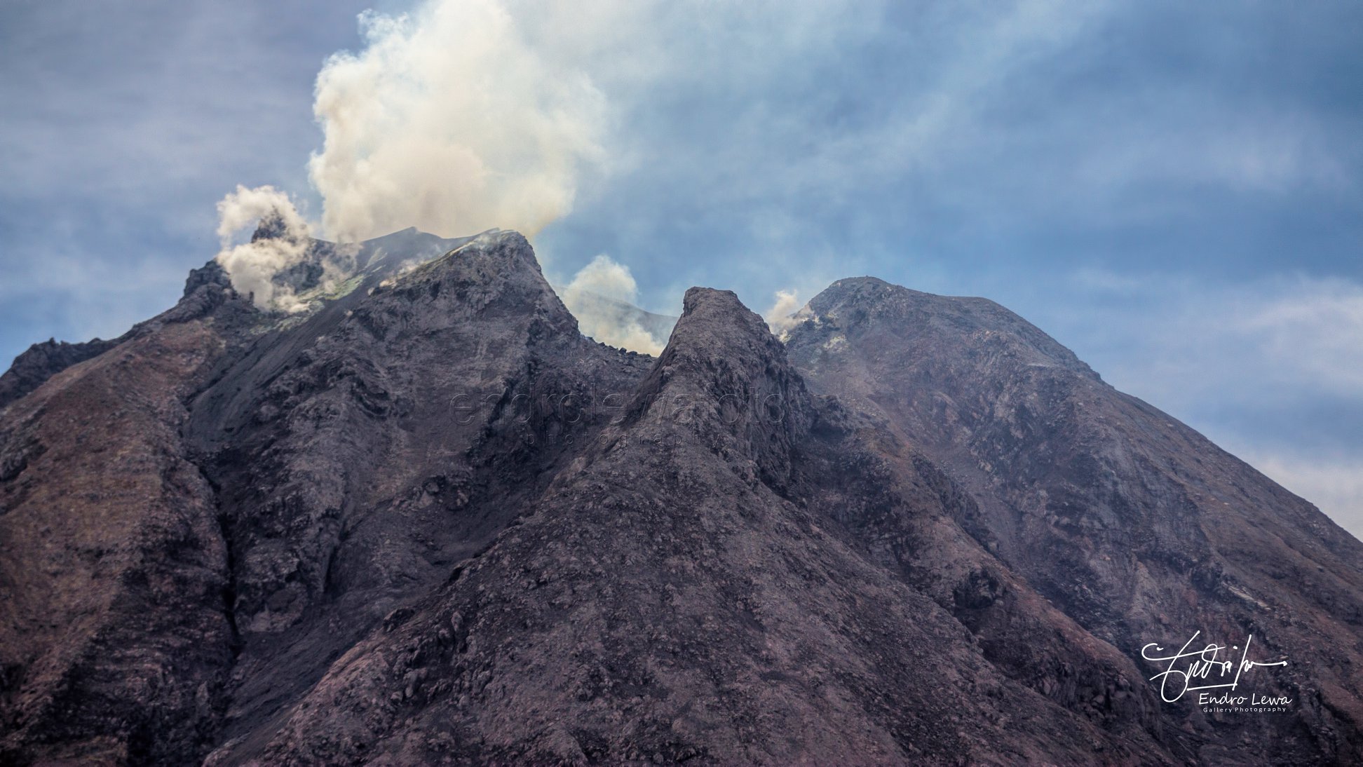
Level IV Activity Level (AWAS). G. Sinabung (2460 m above sea level) has been in constant eruption since 2013.
Since yesterday until this morning, visually the volcano can be observed clearly until the appearance of fog. Crater smoke is observed in white, low pressure and thick intensity with a height of 50 to 200 m above the summit. The wind was weak in the southeast and east.
According to the seismographs, on June 13, 2018, it was recorded:
4 emission earthquakes
1 low frequency earthquake
3 local tectonic earthquakes
7 distant tectonic earthquake
Dams in the Laborus River formed by the accumulation of hot cloud deposits could cause lahars or floods if these dams collapse.
Recommendations:
Communities / visitors should not engage in activities within a radius of 3 km around the summit, and sectorally within 7 km south-southeast, 6 km southeast and 4 km north – East.
Considering that dams have been created upstream of the Laborus River, residents living downstream around the watersheds must be vigilant because these dams can deteriorate due to the volume of water, resulting in lahars / floods downstream.
Source : Magma Indonesia
Photo : Endro Lewa