June 12 , 2018.
Kilauea / Pu’u ‘Ō’ō , Hawai :
Sunday, June 10, 2018, 10:26 PM HST (Monday, June 11, 2018, 08:26 UTC)
19°25’16 » N 155°17’13 » W,
Summit Elevation 4091 ft (1247 m)
Current Volcano Alert Level: WARNING
Current Aviation Color Code: RED
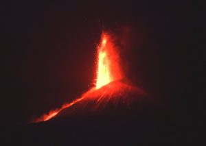
Kīlauea Volcano Lower East Rift Zone
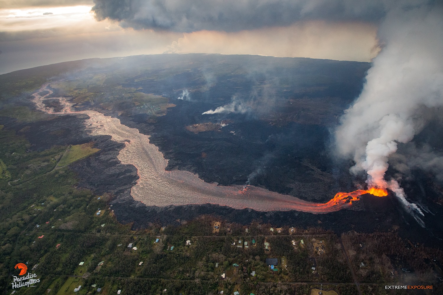
Vigorous eruption of lava continues from the lower East Rift Zone (LERZ) fissure system in the area of Leilani Estates.
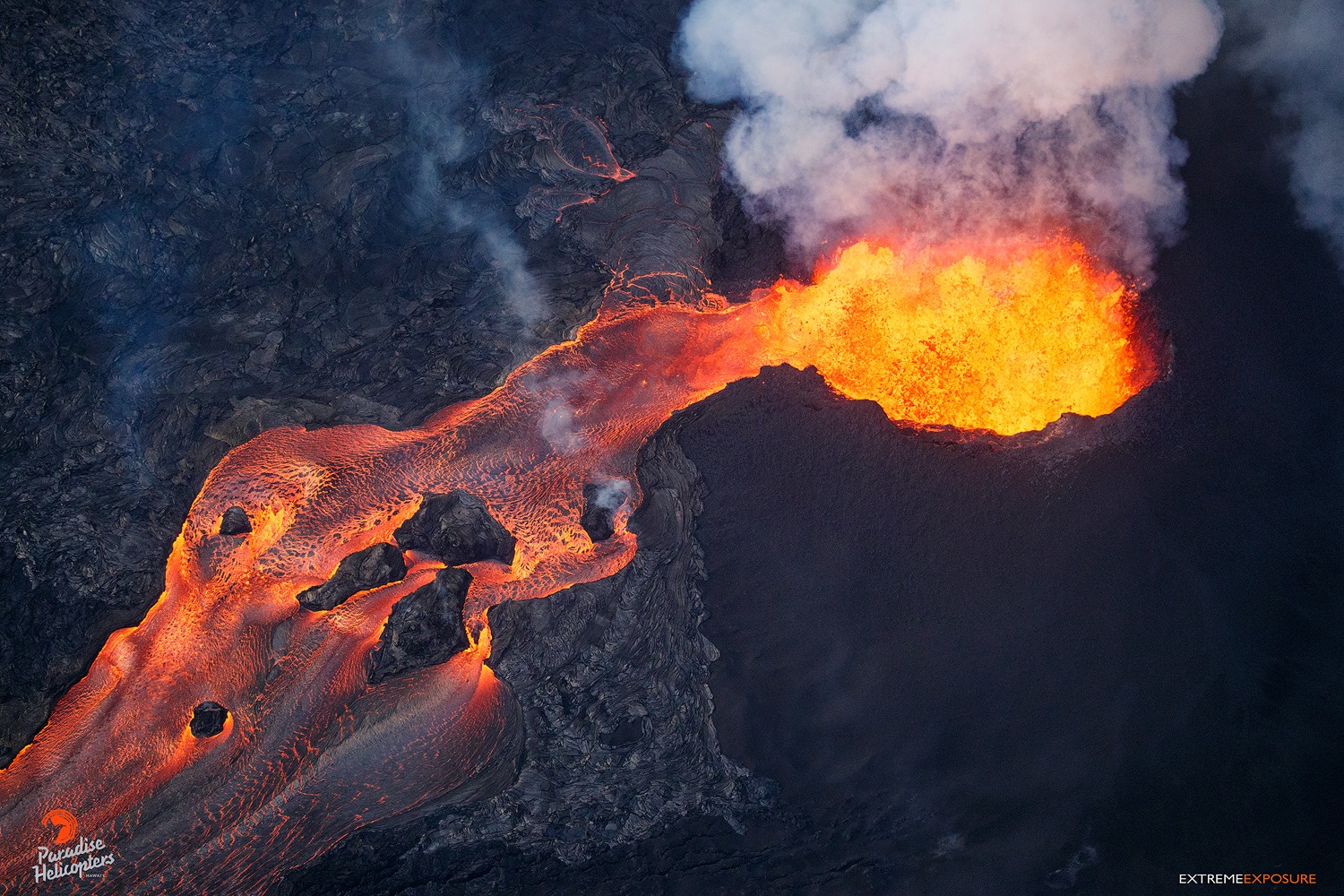
The three closely spaced lava fountains at Fissure 8 are erupting with maximum heights reaching 150-180 feet. Lava continues to be fed into the channelized flow trending north and then east to the ocean entry at Kapoho. Very minor spillovers are occurring at multiple places along the channel but have uniformly been short lived and are not threatening areas that were not previously covered by lava. Gas emissions from the fissure eruption continue to be very high. The late afternoon overflight noted a vigorous plume rising from the ocean entry with minor steam explosions at the leading edge.
There are now 3 distinct fountains at fissure 8 as well as higher volume that is coming out now.
Minor incandescence and lava activity at Fissures 16/18 is continuing but not feeding significant flows. No other fissure is showing activity at this time.
Pele’s hair and other lightweight volcanic glass from fountaining of Fissure 8 are falling downwind of the fissure and accumulating on the ground within Leilani Estates. High winds may waft lighter particles to greater distances. Residents are urged to minimize exposure to these volcanic particles, which can cause skin and eye irritation similar to volcanic ash.
https://www.facebook.com/ikaika.marzo/videos/1833711230014738/
HVO field crews are on site tracking the fountains, lava flows, and spattering from Fissure 8 as conditions allow and are reporting information to Hawaii County Civil Defense. Observations are also collected on a daily basis from cracks in the area of Highway 130; no changes in temperature, crack width, or gas emissions have been noted for several days.
Volcanic gas emissions remain very high from Fissure 8 eruptions. Yesterday, gas emissions were measured to be nearly twice the value measured during the past two weeks. Trade wind conditions are expected to bring vog to the south and west sides of the Island of Hawaii.
Kīlauea Volcano Summit
There have been no ash emissions since early this morning; however, seismicity at the summit is increasing. If the pattern observed before previous explosions persists, we expect another event in the next few hours. Inward slumping of the rim and walls of Halema`uma`u continues in response to ongoing subsidence at the summit.
Sulfur dioxide emissions from the volcano’s summit have dropped to levels that are about half those measured prior to the onset of the current episode of eruptive activity. This gas and minor amounts of ash are being transported downwind, with small bursts of ash and gas accompanying intermittent explosive activity.
Monday, June 11, 2018, 9:01 AM HST (Monday, June 11, 2018, 19:01 UTC)
Kīlauea Volcano Lower East Rift Zone
Eruption of lava continues from the lower East Rift Zone (LERZ) fissure system in the area of Leilani Estates.
The three closely spaced lava fountains at Fissure 8 are erupting with a slightly lower maximum heights of 115-130 feet. Lava continues to be fed into the channelized flow trending north and then east to a single ocean entry at Kapoho. Weak lava activity at Fissures 16/18 was observed last night. This morning’s overflight confirms that fountaining continues at Fissure 8 and that its channel is nearly full with no spillovers. Minor steam explosions were observed at the ocean entry.
Kīlauea Volcano Summit
Overnight, there were two explosions at the volcano’s summit. The first, smaller event occurred at 12:46 AM. Following this event, seismicity did not significantly drop off and a second explosion occurred at 4:43 AM. This event was larger than the first and was more typical of the size of events that have been occurring at the summit over the past week. Inward slumping of the rim and walls of Halema`uma`u continues in response to ongoing subsidence at the summit.
Monday, June 11, 2018, 4:09 PM HST (Tuesday, June 12, 2018, 02:09 UTC)
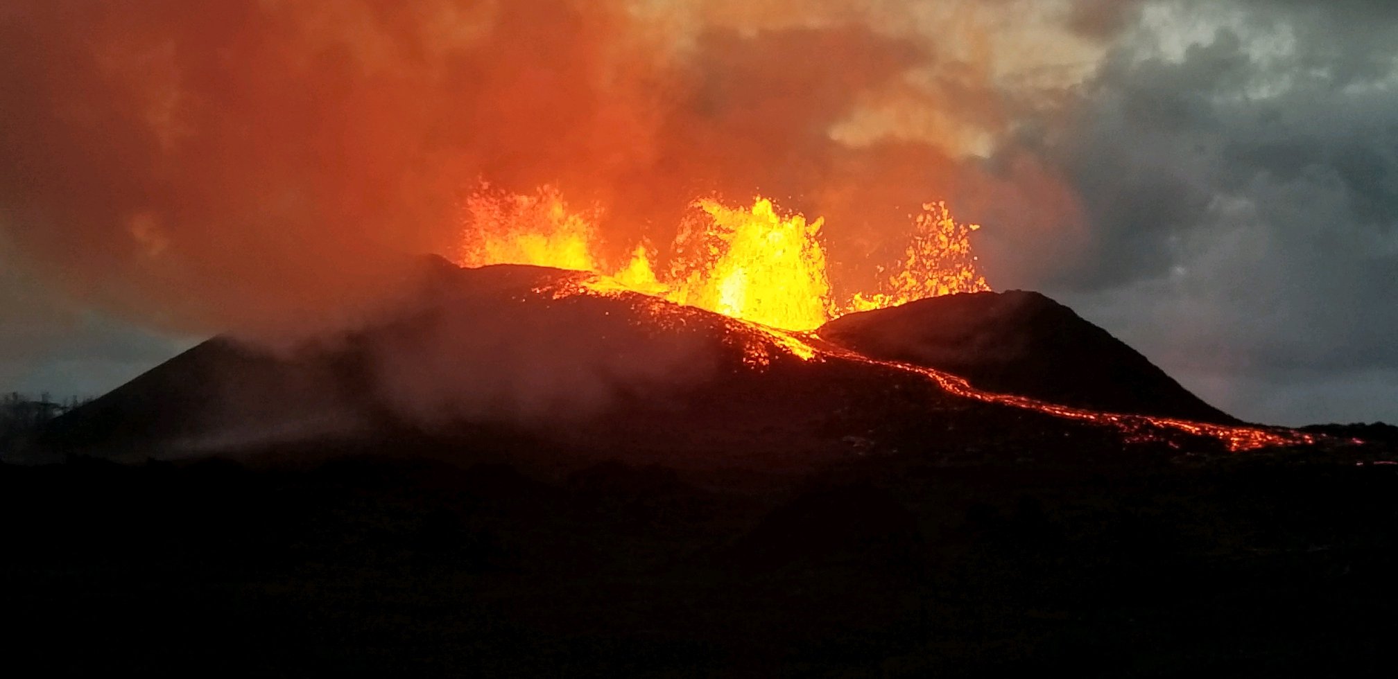
Kīlauea Volcano Lower East Rift Zone
Eruption of lava continues from the lower East Rift Zone (LERZ) fissure system in the area of Leilani Estates.
Three closely spaced lava fountains at Fissure 8 are erupting with fluctuating heights from below the 115 ft high spatter cone around it up to 180 feet. Lava continues to be fed into the channelized flow trending north and then east to a single ocean entry at Kapoho. Weak lava activity at Fissures 16/18 was observed last night. This morning’s overflight confirms that fountaining continues at Fissure 8 and that its channel is nearly full with no spillovers. Minor steam explosions were observed at the ocean entry.
https://www.facebook.com/USGSVolcanoes/videos/2061055213923029/
Kīlauea Volcano Summit
Seismicity levels have been increasing since the most recent small explosion at 4:43 AM this morning. There have been no ash emissions since that early morning event. Inward slumping of the rim and walls of Halema`uma`u continues in response to ongoing subsidence at the summit.
Sulfur dioxide emissions from the volcano’s summit have dropped to levels that are about half those measured prior to the onset of the current episode of eruptive activity. This gas and minor amounts of ash are being transported downwind, with small bursts of ash and gas accompanying intermittent explosive activity.
Source : HVO
Photos : Usgs , Bruce Omori.
Video : Ikaika Marzo, Usgs .
Fuego , Guatemala :
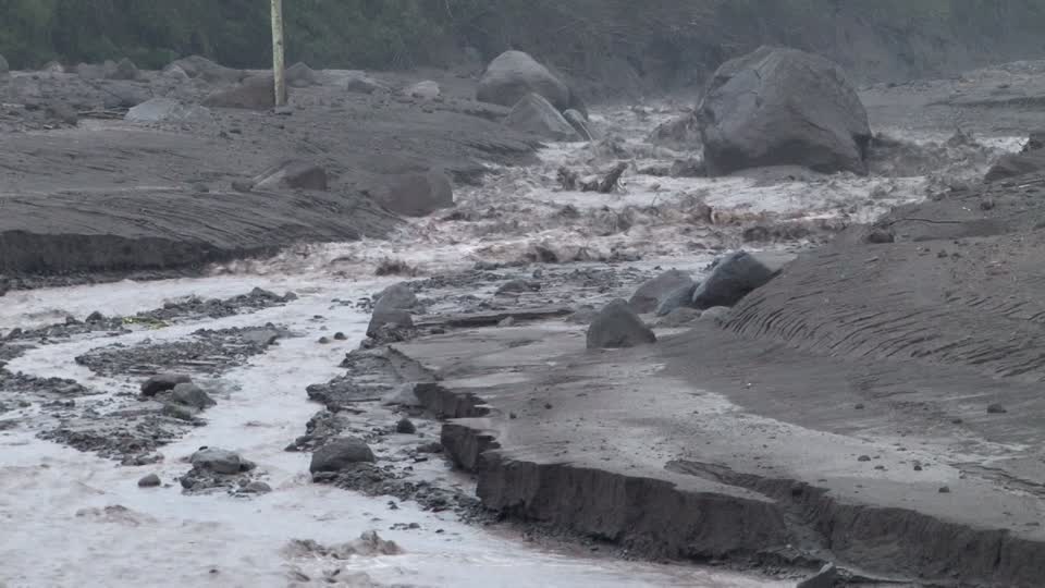
SPECIAL BEFGO VULCANOLOGICAL BULLETIN # 56-2018 Powerful Lahar in the ravine LAS LAJAS.
Type of activity: Vulcanian
Morphology: Composite Stratovolcano
Location: 14 ° 28’54˝ Latitude N; 90 ° 52’54˝Longitude W.
Height: 3,763msnm.
Guatemala 11 June 2018, 17:50 (Local time)
Due to continuous rains in the region of Fuego volcano, it is currently recorded the descent of a lahar in the canyon of Las Lajas and El Jute. Their dimensions are approximately 35 to 55 meters wide and 5 meters high, which causes vibrations on their way. The materials of these lahars are: a lot of fine material that is pasty, blocks up to 3 meters in diameter that slide trunks and tree branches in their path. Due to the last rash these come down with a smell of sulfur. A feeling of heat and steam emanates due to the temperature.
Due to the rains that are generated, the probability of lahars in one of the main ravines is not excluded.
Source : Insivumeh
Great Sitkin , Aleutians Islands:
52 ° 4’35 « N 176 ° 6’39 » W,
Summit: 5709 ft (1740 m)
Current Volcano Warning Level: NOTICE
Current Aviation Color Code: YELLOW

A small steam explosion was detected in seismic data at 11:39 AKDT (19:39 UTC) on June 10, 2018 followed by a series of small earthquakes. The Color Code/Alert Level for Great Sitkin was raised to YELLOW/ADVISORY. No infrasound signal from this event was detected, Meteorological clouds at 8000 feet a.s.l. obscured satellite views of the volcano. No volcanic clouds observed in satellite images above the cloud deck. The earthquake activity has been diminishing over the past 24 hours. The minor explosive event yesterday was similar to the events in January and July of 2017.
Source : AVO
Popocatepetl , Mexico :
June 11, 11:00 am (June 11, 16:00 GMT)
In the last 24 hours, through the monitoring systems of the Popocatepetl volcano, 19 low-intensity exhalations accompanied by water vapor and gas were identified, as well as two explosions recorded at 17:24 and 02:20 in recent years. emitted incandescent fragments. During the night, we observe an incandescence which increases at the time of certain exhalations.
https://www.facebook.com/actividadvolcanpopocatepetl/videos/295909074280455/
A big show of the Popocatepetl volcano yesterday at sunset. The sun was setting right behind the crater and at that moment there was an explosion
At the time of this report, it is observed that the wind disperses the emissions towards South-South-West.
CENAPRED urges not to approach the volcano and especially the crater, because of the risk of falling ballistic fragments, and in case of heavy rains, to move away from the bottoms of the ravines because of the risk of landslides and mudslides.
The Popocatepetl volcanic warning light is located at Amarillo Phase 2.
Source : Cenapred.
Vidéo : Volcan Popocatepetl.