June 05 , 2018 .
Pu’u ‘Ō’ō / Kilauea , Hawai :
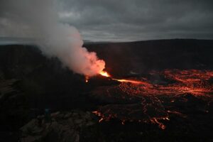
Kilauea – 04 June 2018, 15:20:07:
A local videographer filmed a lava inlet in Kapoho Bay from 10:30 pm on June 3rd. The entrance was not associated with a seismic signal. The 6-hour flight will confirm the entrance and its features.
Monday, June 4, 2018, 8:49 AM HST (Monday, June 4, 2018, 18:49 UTC)
19°25’16 » N 155°17’13 » W,
Summit Elevation 4091 ft (1247 m)
Current Volcano Alert Level: WARNING
Current Aviation Color Code: RED
Kīlauea Volcano Lower East Rift Zone
Vigorous eruption of lava continues from the lower East Rift Zone (LERZ) fissure system in the area of Leilani Estates and Lanipuna Gardens.
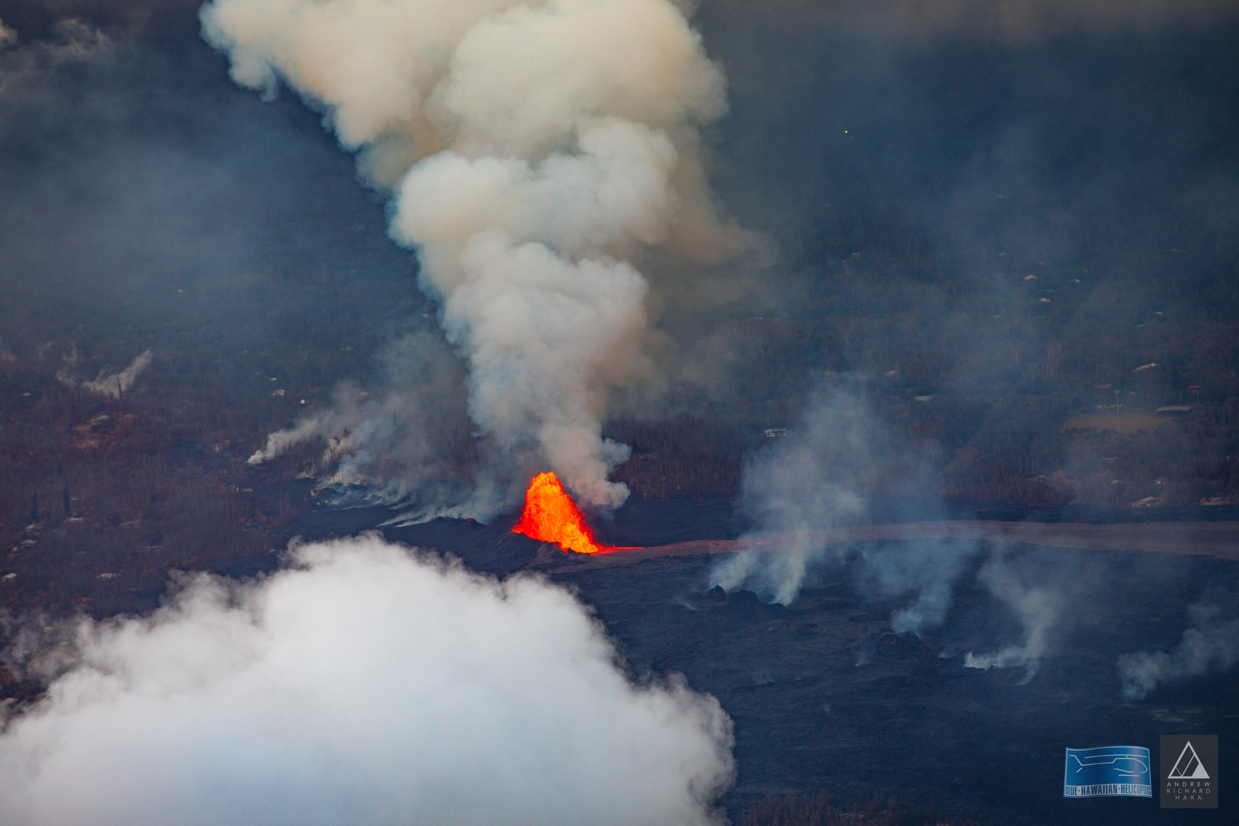
Fountaining at Fissure 8 continued overnight, feeding a robust lava channel to northeast along Highway 132 to the Kapoho area. Local videographers reported that lava entered the ocean at Kapoho Bay at about 10:30 PM HST on June 3. As of 6:30 AM on June 4, lava is constructing a delta in Kapoho Bay extending a few hundred yards into the bay. A laze plume is blowing inland from the ocean entry but dissipating quickly. The lava flow front is about 0.5 miles wide. A lava breakout is also occurring upslope of the Kapoho cone cinder pit, with active flows about 330 yards southeast of the intersection of Railroad Avenue and Cinder Road.
Sluggish lava flows are present in the vicinity of Fissure 18; all other fissures are inactive.
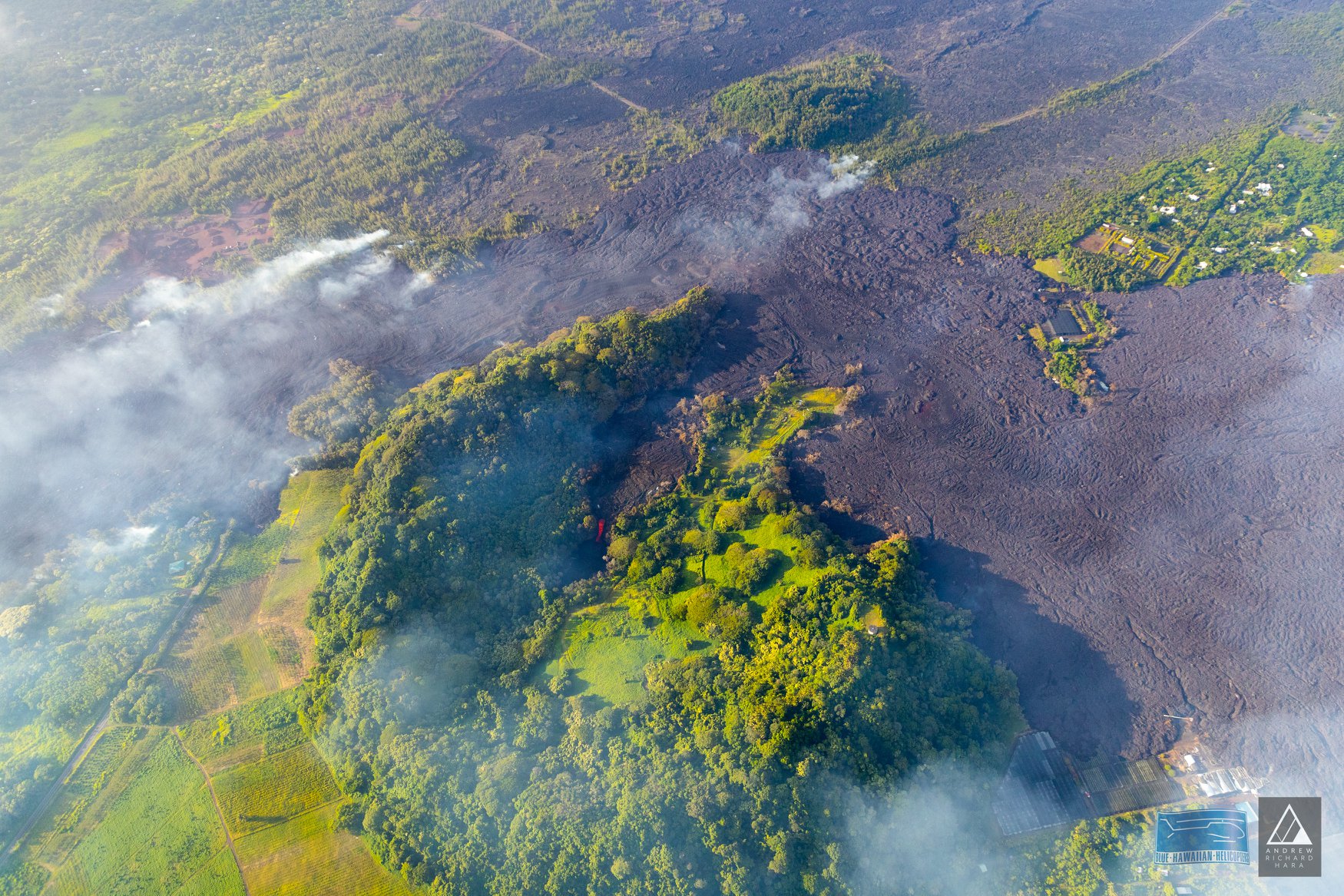
Pele’s hair and other lightweight volcanic glass from high fountaining of Fissure 8 are falling downwind of the fissure and accumulating on the ground within Leilani Estates. Winds may waft lighter particles to greater distances. Residents are urged to minimize exposure to these volcanic particles, which can cause skin and eye irritation similar to volcanic ash.
HVO field crews are on site tracking the fountains, lava flows, and spattering from multiple fissures as conditions allow and are reporting information to Hawaii County Civil Defense.
Volcanic gas emissions remain very high from the fissure eruptions. Trade wind conditions are bringing vog to the south and west sides of the Island of Hawaii. Afternoon easterly winds may bring vog to communities in the Volcano area.
Magma continues to be supplied to the lower East Rift Zone. Earthquake locations have not moved farther downrift in the past few days and the number of located earthquakes remains low. Seismicity remains relatively low with numerous small magnitude earthquakes and low amplitude background tremor.
Additional ground cracking and outbreaks of lava in the area of the active fissures are possible. Residents downslope of the region of fissures should heed all Hawaii County Civil Defense messages and warnings.
USGS/HVO continues to monitor the lower East Rift Zone activity 24/7 in coordination with Hawaii County Civil Defense.
Kīlauea Volcano Summit
Following the small explosion at about 3:50 PM HST on June 3, earthquake activity at the summit has been low. Inward slumping of the rim and walls of Halema`uma`u continues in response to persistent subsidence. We expect that earthquake rates may increase in the coming hours to days and culminate in another small explosion, following the pattern of the past few weeks.
Monday, June 4, 2018, 5:30 PM HST (Tuesday, June 5, 2018, 03:30 UTC)
Kīlauea Volcano Lower East Rift Zone
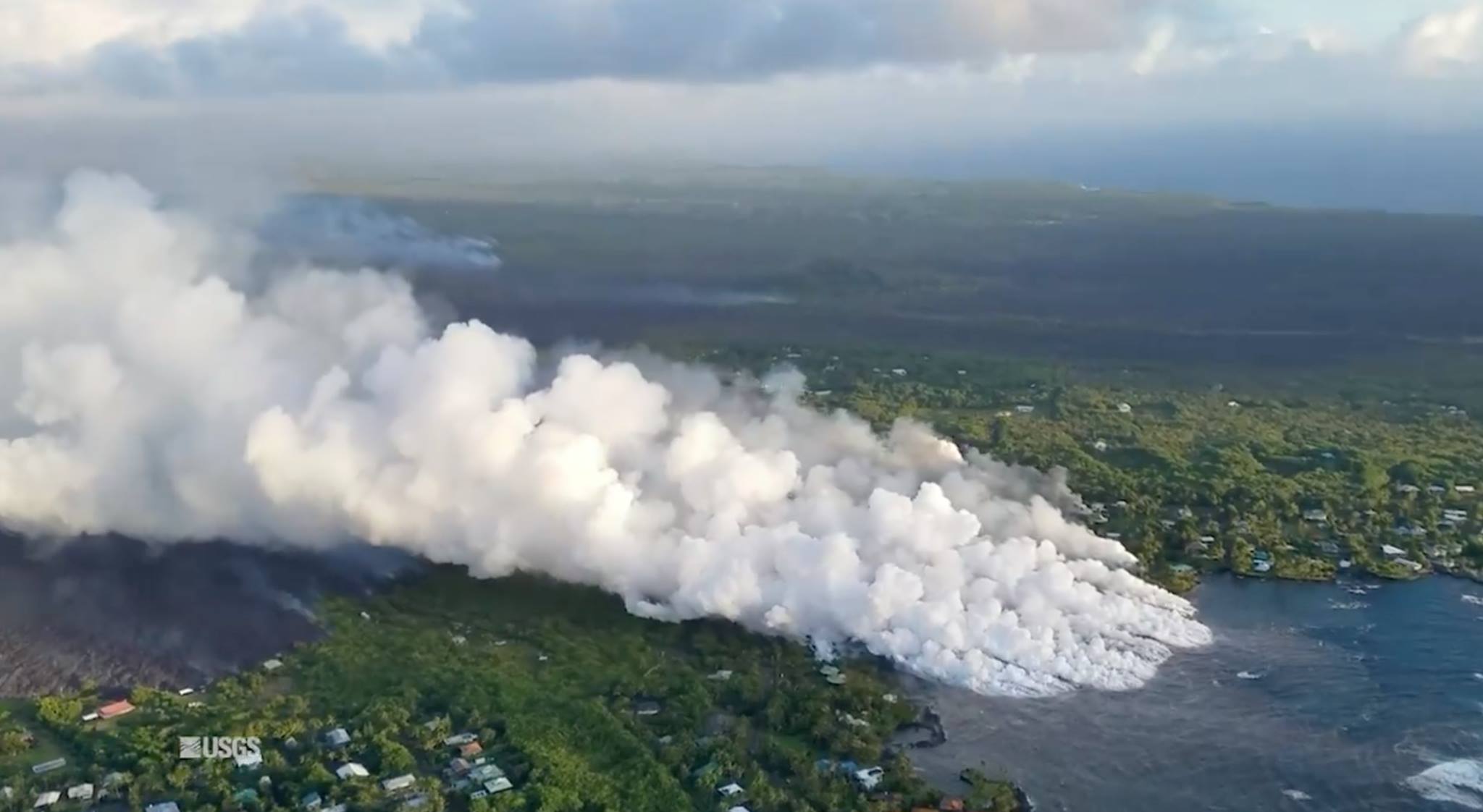
Fountaining at Fissure 8 continued feeding a robust lava channel to northeast along Highway 132 to the ocean entry in Kapoho bay. As of late afternoon the lava entry had built a delta extending approximately 700 yards into the bay. A laze plume is blowing inland from the ocean entry but dissipating quickly. The lava flow front is about 600 yds wide. A lava breakout was also occurring upslope of the Kapoho cone cinder pit but stalled about 300 yards southeast of the intersection of Railroad Avenue and Cinder Road.
Sluggish lava flows are present in the vicinity of Fissure 18; all other fissures are inactive.
Kīlauea Volcano Summit
Earthquake activity at the summit has been low after the explosive eruption yesterday, but is slowly increasing. Inward slumping of the rim and walls of Halema`uma`u continues in response to persistent subsidence. We expect that earthquake rates may increase in the coming hours to days and culminate in another small explosion, following the pattern of the past few weeks.
Source : HVO
Photos : Andrew Hara , USGS.
Video : Big Island Vidéo News
Fuego , Guatemala :
MORE THAN A MILLION PEOPLE AFFECTED BY THE ERUPTION OF THE FUEGO VOLCANO.
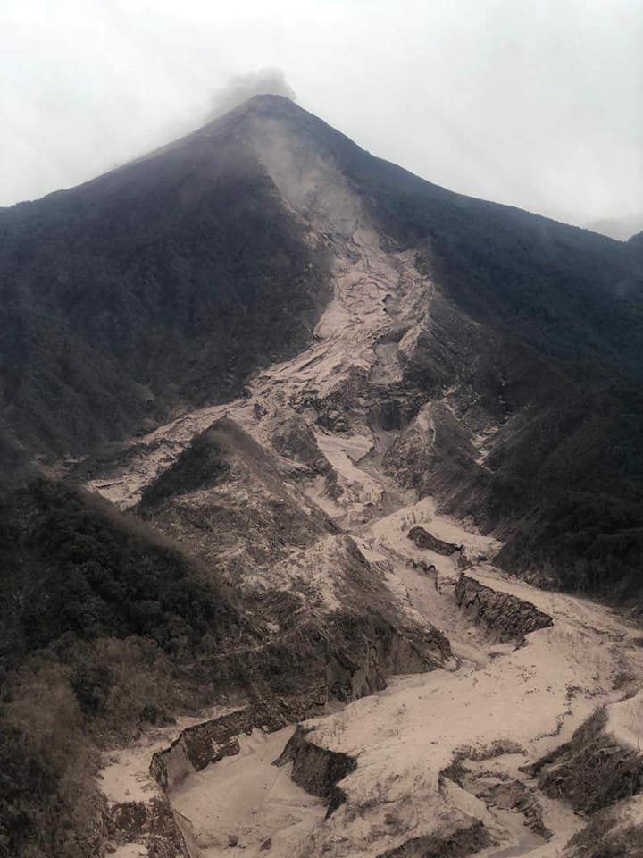
After the Fuego volcano began its second eruption, ash columns reached an altitude of more than 10 thousand meters, pyroclastic flows descended by the canyons from this volcanic dome, the burning clouds descending from the crater generated damage in neighboring communities, as well as the descent of strong lahars who take the direction of the neighboring rivers.
The institutions of the national coordination system for disaster prevention-Conrad have already provided assistance in 62 incidents mainly in the departments of Sacatepéquez, Chimaltenango and Escuintla, with a total of one million 701,965 people affected, 3,100 were assisted and evacuated, 20 wounded people transferred to medical centers, 25 dead and a bridge completely destroyed due to the descent of a fort lahar.
https://www.facebook.com/cayaya.birding/videos/10156239727941777/
Among the actions already underway is the search and location of missing persons, the opening of 3 shelters in the Escuintla department, assistance to the wounded, needs analysis and damage assessment in the affected areas , the mobilization of immediate response equipment -ERI-, among others, these are framed in the alert statement level Orange and Red at the municipal level in the municipalities most affected.
Populations that are close to the most affected areas are INFORMED not to expose themselves to the burning clouds, pyroclastic flows or lahars that may still arrive in this volcanic region and to respond to recommendations issued by the authorities at any time to be aware of new information generated about this second Fuego volcano eruption.
After completion of the second Fuego volcano eruption, constant surveillance is maintained. So far, the seismic station has recorded internal tremors and explosions classified as weak to moderate, with a range of 5 to 7 hours. This activity is considered a normal activity, in addition to the constant avalanches that generate the removal of material due to the instability in which the affected areas are immersed. Because fine pyroclastic materials have deposited in the ravines, remobilization of ashes occurs, which are scattered to the southwest, west, northwest, and north. Communities in these areas will be affected by this ashes.
The explosions are heavily laden with ash and rise to a height of approximately 4500 to 4600 meters (14,765 to 15,090 feet) southwest, west, northwest and north, dispersed over 15 km. Sound rumblings are generated, heard 15 km away from the volcanic perimeter.
If there is a change in the morphology of the cone or an increase in seismic signals, it will be informed to alert the population.
At least 69 people died in Guatemala because of the powerful eruption of the Fuego volcano, which devastated several neighboring villages with an avalanche of mud and burning ash, authorities said Monday.
The note indicates that so far only 17 people have been identified by means of « fingerprints and physical characteristics ».
Source : Conred , Insivumeh , Prensa Libre .
Video : Knut Eisermann
Photo : Sismologia Mundial
Sabancaya , Peru :
The explosive activity does not show any significant changes. An average of 28 explosions / day was recorded, a value lower than that recorded the previous week (35 explosions / day). Events associated with fluid movements (long period type) continue to predominate. There was a significant tremor activity associated with the emission of ash and gas (about 7 hours). Earthquakes associated with the rise of magma (type Hybrids) are low in number and energy.
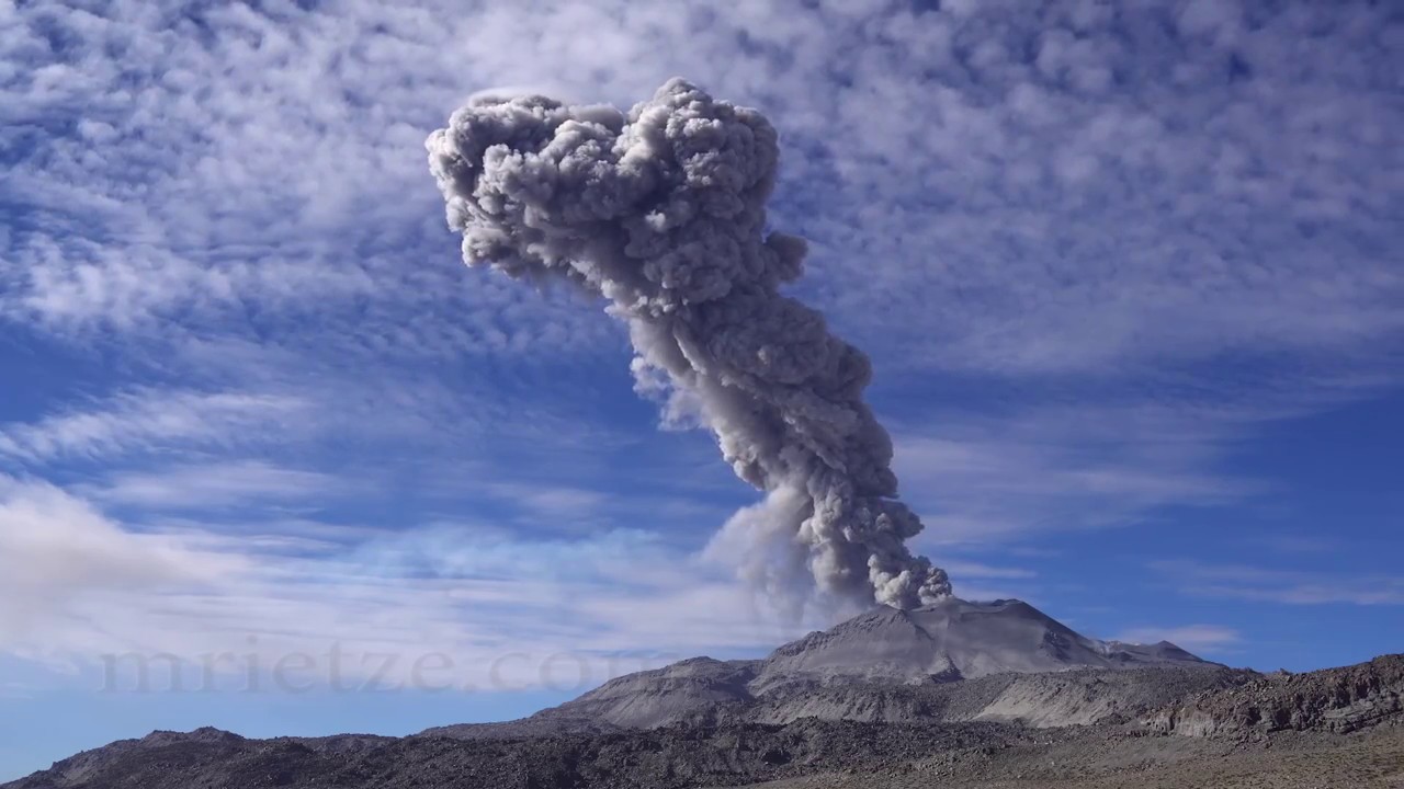
The eruptive columns of gas and ash reached a maximum height of about 4300 m above the crater. The dispersion of these materials occurred within a radius of about 40 km, mainly to the northeast, east and southeast.
The volcanic gas (SO2) flux recorded on May 30 has a maximum value of 5571 tonnes / day, a value considered large.
The volcanic recordings at the SBSE GPS station did not show any significant changes in the deformation.
6 thermal anomalies, according to the Mirova system, were recorded, with values between 1 and 26 MW VRP (Radiated Volcano Power).
In general, eruptive activity maintains moderate levels. No significant changes are expected in the following days.
Source : IGP
Photo : Martin Rietze.
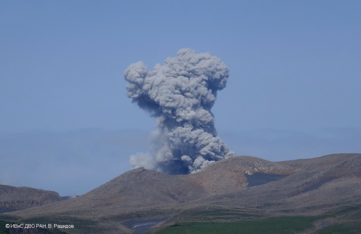
Ebeko , Kamchatka :
VOLCANO OBSERVATORY NOTICE FOR AVIATION (VONA).
Issued: June 05 , 2018.
Volcano:Ebeko (CAVW #290380)
Current aviation colour code:ORANGE
Previous aviation colour code:orange
Source:KVERT
Notice Number:2018-49
Volcano Location:N 50 deg 41 min E 156 deg 0 min
Area:Northern Kuriles, Russia
Summit Elevation:3791.68 ft (1156 m)
Volcanic Activity Summary:
Weak ash plume extended about 8 km to the east from the volcano.
A moderate gas-steam with some amount of ash activity of the volcano continues. Ash explosions up to 16,400 ft (5 km) a.s.l. could occur at any time. Ongoing activity could affect low-flying aircraft and airport of Severo-Kurilsk.
Volcanic cloud height:
8200-9840 ft (2500-3000 m) AMSL Time and method of ash plume/cloud height determination: 20180605/0114Z – MODIS TERRA (31m32)
Other volcanic cloud information:
Distance of ash plume/cloud of the volcano: 5 mi (8 km)
Direction of drift of ash plume/cloud of the volcano: E / azimuth 90 deg
Source : Kvert
Photo : V. Rashidov, IVS FEB RAS , 10/8/2017.