May 31 , 2018.
Pu’u ‘Ō’ō / Kilauea , Hawai :
Tuesday, May 29, 2018, 10:28 PM HST (Wednesday, May 30, 2018, 08:28 UTC)
19°25’16 » N 155°17’13 » W,
Summit Elevation 4091 ft (1247 m)
Current Volcano Alert Level: WARNING
Current Aviation Color Code: RED
Kīlauea Volcano Lower East Rift Zone
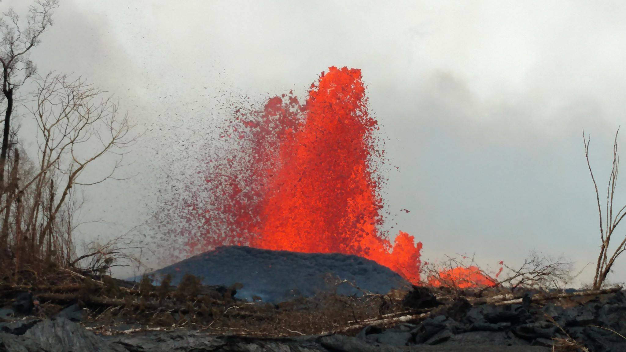
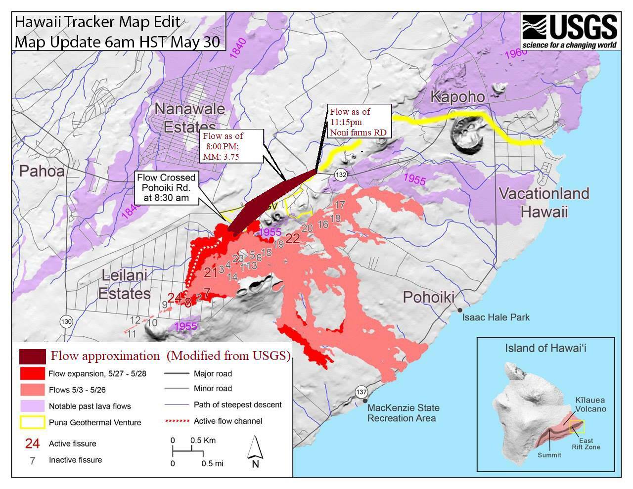
Vigorous eruption of lava continues from the lower East Rift Zone (LERZ) fissure system in the area of Leilani Estates and Lanipuna Gardens.
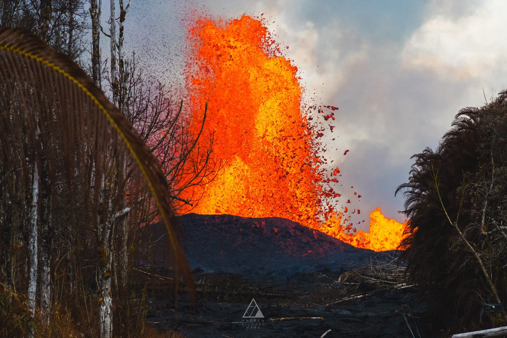
Fissure 8 remained very active Tuesday afternoon and evening, fountaining to heights of 200 feet at times and feeding a lava flow that advanced atop an existing flow (which was emplaced on Sunday night/Monday morning). After a finger of lava crossed Highway 132 earlier this afternoon near the PGV access road, the bulk of the lava remained on the south side of the highway, roughly paralleling the highway as it moved downslope.
Visual observations early Tuesday afternoon also confirmed continued weak activity at Fissures 18 and 16. Fissure 18 is producing channelized flows which had advanced to within 0.9 miles of the coast as of 7:10 PM HST. On Tuesday evening, Hawaii County Civil Defense began providing preliminary warnings to residents in the area to be prepared to evacuate if the flow continues to advance and threatens to cut Highway 137.
Pele’s hair and and other lightweight volcanic glass from high fountaining of Fissure 8 are being transported downwind and falling to the west of the fissure. On Monday night, there were reports of Pele’s hair falling in Pāhoa. Residents are urged to minimize exposure to these volcanic particles, which can cause skin and eye irritation similar to volcanic ash.
Kīlauea Volcano Summit
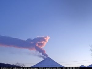
Ash continued to erupt intermittently from the vent within Halemaʻumaʻu crater, at Kīlauea’s summit. Additional explosive events that could produce minor amounts of ash fall downwind are possible at any time. Volcanic gas emissions at the summit remain high.
https://www.facebook.com/ryanfinlay/videos/10155795350535749/
May 30 , 2018 1:30am County of Hawaii Civil Defense, Kapoho Beach lots & Vacationland advised to evacuate:
A message from COUNTY OF HAWAII
This is a Civil Defense Message for Wednesday, May 30 at 1:30 in the morning.
Hawaii Volcano Observatory reports that the lava flow near Highway 132 has gained speed and is now advancing rapidly. Due to this advance in speed, residents in the Kapoho area including Kapoho Beach Lots and Vacationland are advised to evacuate. You are at risk of being isolated due to possible lava inundation of Beach Road near Four Corners. At the present rate of flow, it is possible that Beach Road near Four Corners may be blocked within 4 to 6 hours.
Wednesday Morning May 30th 6am HST
In the middle of the night, the lava flow from fissure almost doubled in speed from 412 feet/per hour to 718 feet/ per hour as it traveled along Highway 132 and triggered first, a mandatory evacuation of Noni Farms Road area and Hale Kamahina road.
Following that, an evacuation warning was sent out at 1:30 am HST for Kapoho, Kapoho Beach Lots and Vacationland.
If nothing changes, lava could cross Highway 137/beach road today sometime.
At 3am from USGS: “F8 flow has left hwy 132 in the vicinity of Noni Farms road and is following a steepest line of descent that would take it to Four Corners. Recent advance rates are about 600 feet/hour.”
Update: as of 6:30am HST nobody is allowed back in past four corners from beach road. They said that may change, but right now that’s what they are saying.
Fissure 8 does not appear to have let up this morning much at all so we can assume that it’s continuing to supply a large amount of lava to this flow.
Fissure 18 is producing channelized flows which has now advanced to within 0.9 miles of the coast as of 7:10 PM HST last night.
Wednesday, May 30, 2018, 6:43 AM HST (Wednesday, May 30, 2018, 16:43 UTC)
Kīlauea Volcano Lower East Rift Zone
Vigorous eruption of lava continues from the lower East Rift Zone (LERZ) fissure system in the area of Leilani Estates and Lanipuna Gardens.
Fissure 8 maintained high fountains throughout Tuesday night and into Wednesday morning, with sustained heights exceeding 200 feet and the presence of multiple secondary fountains that reached to 60 feet. This fountaining continued to feed a lava flow that moved downslope along Highway 132. Advance rates accelerated late Tuesday and early Wednesday, reaching approximately 600 yards/hour. The flow moved north of Highway 132 in the vicinity of Noni Farms and Halekamahina roads, advancing along a steepest descent path that could take the flow to the Four Corners area.
The Fissure 18 flow also remained active, moving downslope toward Highway 137 at rates of less than 100 yards per hour. Overnight, sporadic bursts of activity were also observed from Fissures 7 and 15.
Pele’s hair and and other lightweight volcanic glass from high fountaining of Fissure 8 are falling to the west of the fissure and accumulating on the ground within Leilani Estates. Winds my waft lighter particles to greater distances. Residents are urged to minimize exposure to these volcanic particles, which can cause skin and eye irritation similar to volcanic ash.
HVO field crews are on site tracking the fountains, lava flows, and spattering from multiple fissures as conditions allow and reporting information to Hawaii County Civil Defense. Crews are also checking on the status of ground cracks on Highway 130.
Volcanic gas emissions remain very high from the fissure eruptions. Wind conditions for Wednesday, May 30, are forecast to result in widespread vog over the Island of Hawaii.
Magma continues to be supplied to the lower East Rift Zone. Earthquake locations have not moved farther downrift in the past few days and the number of located earthquakes remains low.
Additional ground cracking and outbreaks of lava in the area of the active fissures are possible. Residents downslope of the region of fissures should heed all Hawaii County Civil Defense messages and warnings.
USGS/HVO continues to monitor the lower East Rift Zone activity 24/7 in coordination with Hawaii County Civil Defense.
Kīlauea Volcano Summit
Ash continued to erupt intermittently from the vent within Halemaʻumaʻu crater, at Kīlauea’s summit, but no small explosive events have been recorded since Tuesday morning. Additional explosive events that could produce minor amounts of ash fall downwind are possible at any time. Earthquake activity is elevated at the summit, with a few events reported felt overnight. Volcanic gas emissions at the summit remain high and will combine with wind conditions to produce widespread vog across the Island of Hawaii on Wednesday
Source : HVO , Hawaii Trackers.
Photos : Ryan Finlay, Andrew Hara .
Vidéos : USGS , Ryan Finlay/Hawai Tracker.
White Island (Whakaari) , New Zealand :
Published: Wed May 30 2018 2:30 PM
Volcanic Alert BulletinVOLCANIC ALERT BULLETIN: WI – 2018/01
2018-05-30 14:15:00 +1200 +1200; White Island Volcano
Volcanic Alert Level remains at 1
Aviation Colour Code remains at Green
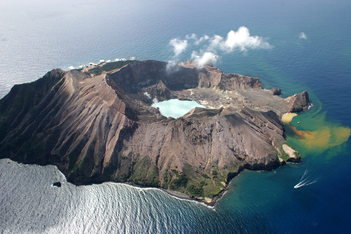
Observations during visits to White Island and from the web cameras confirm that the crater lake is starting to reform and volcanic activity remains at low levels.
In the past few weeks water has ponded on the floor of the active crater and started to reform a permanent lake. Volcanic activity is confined to the gas rich vents on the western side of the active crater. Hot, clear gas continues to be emitted. The seismic and acoustic activity generally remain low, and the SO2 gas flux is also low.
In mid-April and again this week visitors to the island have experienced loud sounds from the active crater area. These are being generated from the vents on the 2012 lava intrusion, the main source of gas and steam in the Main Crater.
The rising lake level and drowning of some gas-steam vents has occurred in the past and minor steam driven activity has occurred near these vents. The current lake level rise is likely to do the same and the effects are likely to only be local to the vents. Seismic activity on the volcano during the last month has been at low levels, punctuated occasionally by weak volcanic tremor and regional earthquakes nearby. There is no substantial change in the level of volcanic activity. The Volcanic Alert Level remains at Level 1 and the Aviation Colour code remains Green.
We continue to monitor the volcano for possible renewed activity.
Activity in the crater lake of White Island has captured the attention of scientists, weeks after visitors heard « loud sounds » coming from the volcano.
According to GNS Science, the noises were first heard in mid-April – and this week and are coming from vents in the main crater.
Alongside the loud sounds, water has started to accumulate in the crater, creating a lake.
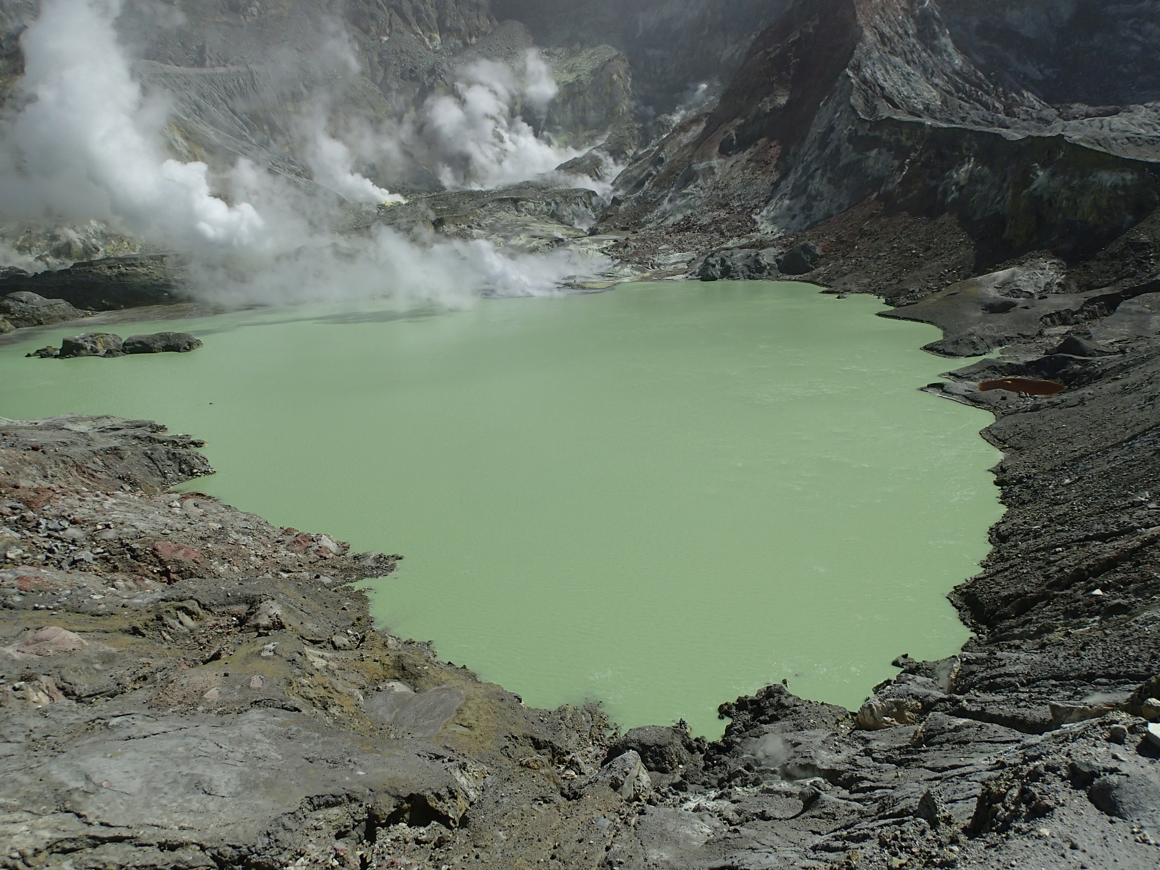
« In the past few weeks, water has ponded on the floor of the active crater and started to reform a permanent lake, » GNS Science said.
« Volcanic activity is confined to the gas-rich vents on the western side of the active crater. »
Despite the sounds and lake reformation, the volcano is not considered to be in danger of erupting as seismic activity remains low.
« The rising lake level and drowning of some gas-steam vents has occurred in the past, and minor steam-driven activity has occurred near these vents, » GNS Science said.
« The current lake level rise is likely to do the same, and the effects are likely to only be local to the vents. »
GNS Science said they will continue to keep an eye on the volcano in case it becomes more active.
Source : Geonet , Agnes Mazot Duty Volcanologist , Newshub.co.nz.
Pacaya , Guatemala :
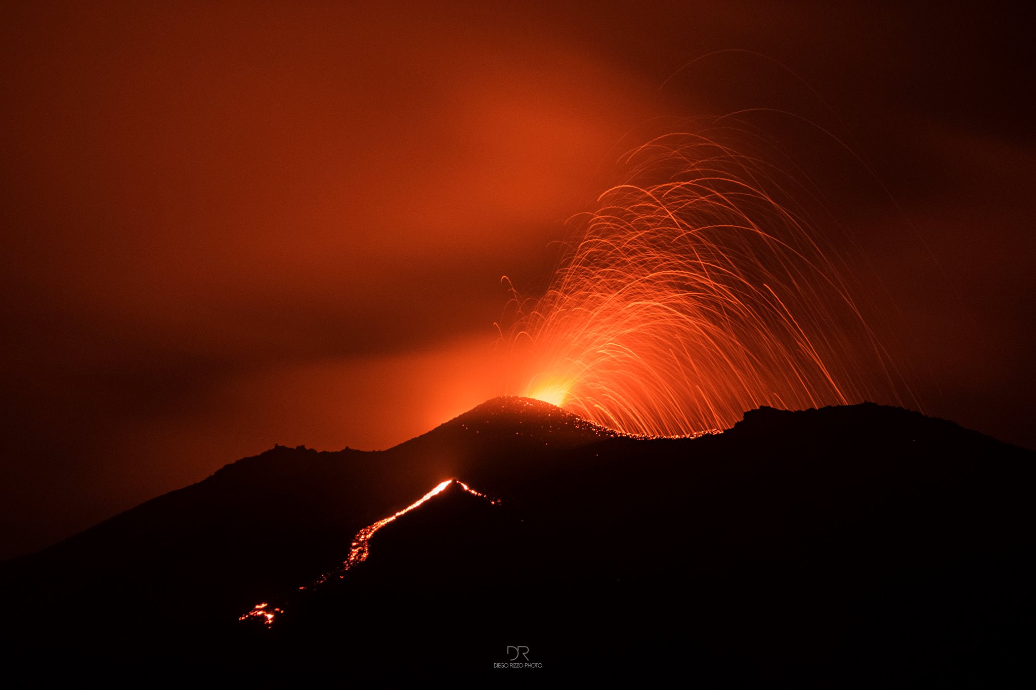
Type of activity: Strombolian
Morphology: Composite Stratovolcano
Location: 14 ° 22’50˝ Latitude N; 90 ° 36’00˝ Longitude W.
Height: 2,552msnm.
Weather conditions: Cloudy
Wind: North
Precipitation: 31.0 mm.
Activity:
Presence of white and sometimes blue degassing at an approximate height of 200 meters above the crater dispersing to the south. Strombolian explosions eject materials in a weak to moderate manner at an approximate height of 50 to 100 meters above the crater with an approximate frequency of 50 per hour. An incandescence is observed in the evening hours. The seismic station records an internal tremor generated by the constant degassing and the rise of the magma.
Source : Insivumeh.
Photo : DR
Cerro Machin , Colombia :
Subject: Cerro Machín Volcano Activity Bulletin.
The level of activity continues at the level: Yellow activity level or (III): changes in the behavior of volcanic activity.
With regard to monitoring the activity of the Cerro Machín volcano, the COLOMBIAN GEOLOGICAL SERVICE informs that:
During the last week, the Cerro Machín volcano recorded a seismic activity associated with the fracturing of the rocks that make up the volcano. This seismic activity shows a slight increase in the number of earthquakes and released seismic energy compared to the previous week.
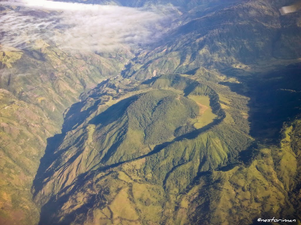
The seismicity was located on the west flank of the main dome, at depths between 2.3 and 4.0 km. The maximum magnitude recorded during the week was M1.0 ML (Local Magnitude) corresponding to the earthquakes recorded on May 24 at 11:33 am and 12:21 pm (local time), located west of the main dome at 3.1 km. depth. The other monitored parameters did not show any significant changes.
The COLOMBIAN GEOLOGICAL SERVICE is attentive to the evolution of the volcanic phenomenon and will continue to inform in a timely manner of the changes that may occur.
Source : SGC.
Photo : Nestoriman
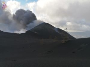
Piton de la Fournaise , La Réunion :
Activity Bulletin from Wednesday, May 30, 2018 at 15:30 (local time):
The eruption started on April 27, 2018 at 23:50 local time continues. The intensity of the volcanic tremor (indicator of eruptive intensity on the surface) continues its very gradual decline.
– Lava flows always occur almost exclusively in tunnel. A strong degassing is always visible in the main vent.
– The overflight of the eruptive site carried out yesterday made it possible to highlight that the main cone is always open at the top with a small eruptive mouth less than 5m in diameter (Figure 2). Small collapses and flank slumps are visible on the outer flanks of the main cone.
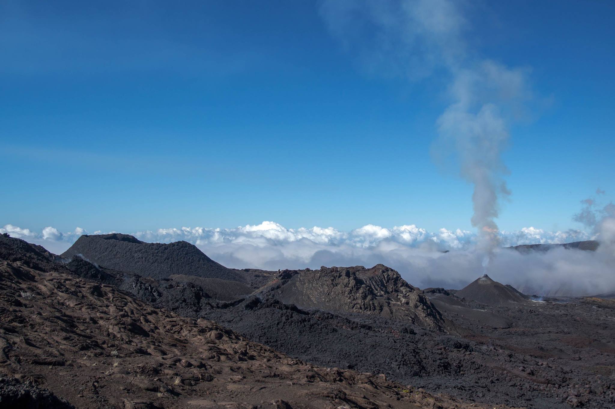
– The inflation of the volcano continues.
– Surface flow rates have become too low to be estimated from satellite data.
– No volcano-tectonic earthquake has been recorded during the last 24 hours under the Piton de la Fournaise volcano.
Alert level: Alert 2-2 – Eruption in the Enclos .
Source : OVPF
Photo : Frédérick LEVENEUR / Fournaise Info