April 02 , 2018.
It is obvious that yesterday’s article about the volcanoes of the Philippines was an April Fool’s fish ….
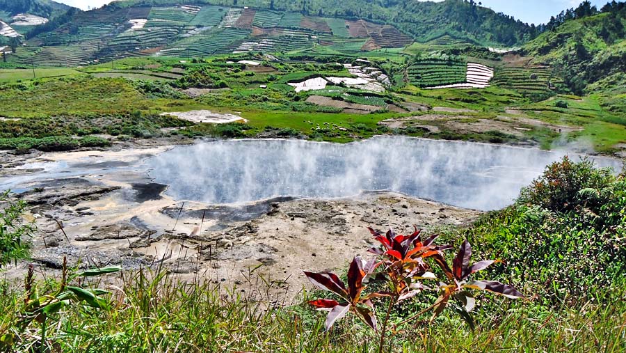
Kawah Sileri , Indonesia :
Suddenly, Sunday (1/4) at 13:42 pm, the Sileri crater located in the Dieng Volcano complex in the Regency of Banjarnegara, Central Java Province, entered a phreatic eruption. The instruments detected toxic gases of the eruption, namely CO2, H2S and SO2.
According to information from the National Disaster Prevention Agency (BNPB), the eruption was accompanied by a mudslide with a height of 150 meters that has progressed up to 100 meters to the East, 50 meters to the North, 200 meters South, 100 meters North West and 50 meters West.
« Before the eruption, black smoke was emitted up to 90 meters altitude, then thick white smoke before erupting followed by strong pressure as high as 150 meters, » said the head of the Information and Public Relations BNPB Sutopo Purwo Nugroho, Sunday afternoon.
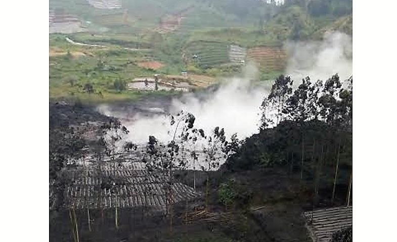
He explained that when the incident occurred, the conditions were rainy, so there were not many tourists. The BNPB assured that no casualties were caused by the conditions of the water eruption.
The phreatic eruption is a type of volcanic eruption caused by the pressure of water vapor at the bottom of the crater, which pushes the mud, smoke and water upwards. The phreatic eruption is difficult to detect.
« It was therefore likely that this eruption could occur at any time, especially during the rainy season when the water mass in the crater comes into contact with the heat inside that causes the pressure of water vapor to rise. » said Sutopo. « We continue to do surveillance, but residents should still not approach 100 meters from the lip of the crater. »
Source : INDOPOS.CO.ID .
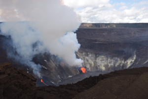
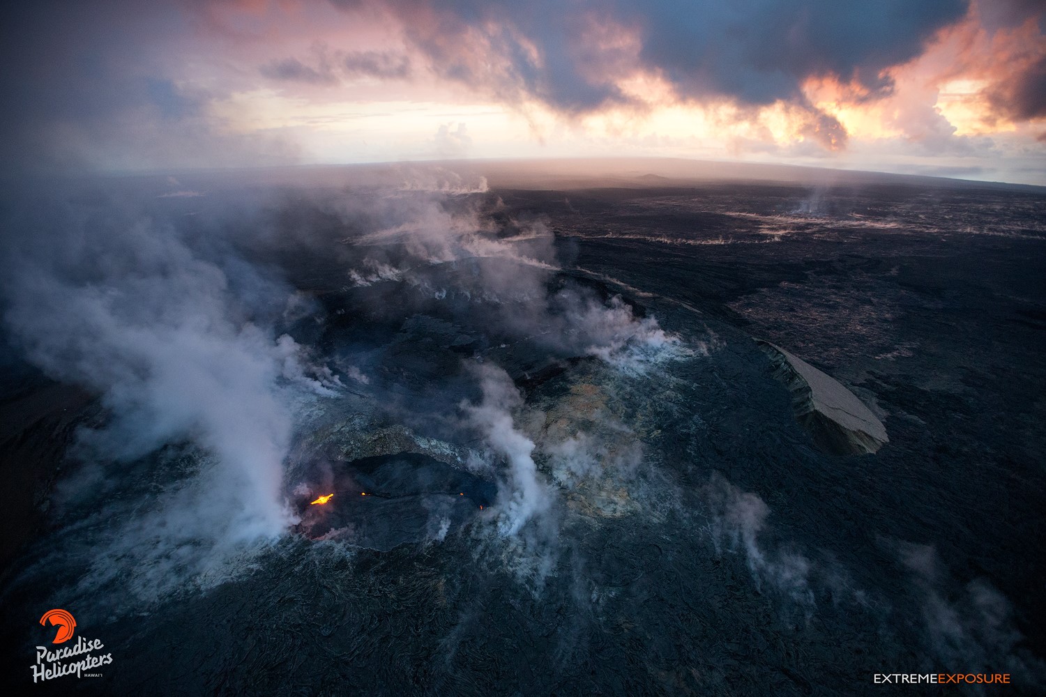
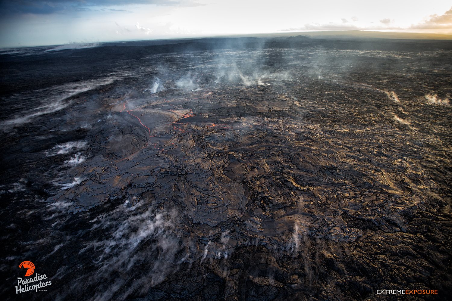
Kilauea , Hawai :
19°25’16 » N 155°17’13 » W,
Summit Elevation 4091 ft (1247 m)
Current Volcano Alert Level: WATCH
Current Aviation Color Code: ORANGE
Activity Summary:
Eruptions at Kīlauea Volcano’s summit and East Rift Zone continue. The depth to the lava lake surface within the Halemaʻumaʻu Overlook vent was 27 m (89 ft) beneath the adjacent crater floor this morning. Puʻu ʻŌʻō cone continues to inflate and has an active lava flow on the crater floor. The Episode 61g lava flow is active above Pulama pali and does not pose a threat to nearby communities at this time. There is currently no active lava on the pali, the coastal plain, or entering the ocean. Low rates of ground deformation and seismicity continue across the volcano.
An overhead view of Pu‘u ‘O‘o, with its west pit containing the lava lake in the foreground, and the main crater behind it. The lighter colored lava in the main crater is the flow that spilled onto its floor a few days ago which has since stagnated.
Summit Observations:
The surface of the lava lake within the Halemaʻumaʻu Overlook vent was measured this morning at 27 m (89 ft) below the adjacent Halemaʻumaʻu crater floor. Summit tiltmeters are recording slight deflationary tilt. The seismicity in the summit area is within normal, background rates, with tremor amplitude fluctuations associated with lava lake spattering. Elevated summit sulfur dioxide emission rates persist.

A rare unobstructed view of Pu‘u ‘O‘o’s collapse pit, with a crusted-over lava lake.
Puʻu ʻŌʻō Observations:
Puʻu ʻŌʻō tiltmeters have been registering relatively steady, minor inflationary tilt recorded over the past week. Lava began flowing onto the floor of Puʻu ʻŌʻō one week ago from a vent in the southeast of the crater. This lava flow continues to expand over the past several days. Webcam views of spattering from the West Pit lava pond also continue. The sulfur dioxide emission rate from the East Rift Zone vents has been steady over the past several months and remains significantly lower than the summit emission rate.
A wide angle shot of the huge breakout, approximately 1/2 mile from the vent. The white gases rising from ground is steam, while the bluish gas is sulfur dioxide, and this particular breakout has been degassing more than we usually see. The somewhat circular area within the rising steam, is where this breakout has covered
Lava Flow Observations:
Overflight observations confirm that there is no lava flow activity from the Episode 61g lava flow on the coastal plain and pali. No lava is flowing into the ocean. Lava flow activity on the upper flow field, closer to Puʻu ʻŌʻō, continues and does not pose a threat to nearby communities at this time.
Source : HVO.
Photos : Bruce Omori .
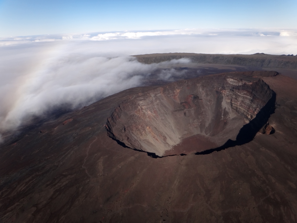
Piton de la Fournaise , La Réunion :
Monthly newsletter for Sunday, April 1, 2018
Seismicity:
In March 2018, the OVPF recorded a total of:
• 114 superficial volcano-tectonic earthquakes (0 to 2 km deep) beneath the summit craters;
• 1 deep earthquake (> 2 km deep);
• 85 collapses (in the crater Dolomieu, at the Enclos Fouqué ramparts and at the eruptive site of July / August 2017);
• 16 local earthquakes (under the island, Piton des Neiges side);
• 2 regional earthquakes (in the Indian Ocean zone).
Following the increase in seismicity recorded during the last fortnight of February, volcano-tectonic activity under the Piton de la Fournaise massif was maintained, with an average of 4 earthquakes per day, and two main peaks of activity. March 28 and 31 (Figure 1).

Figure 1: Histogram representing the number of superficial volcano-tectonic earthquakes recorded under the summit craters between January 1 and March 31, 2018. (© OVPF / IPGP)
Deformation
Inflation (swelling) continued throughout March (Figure 2).
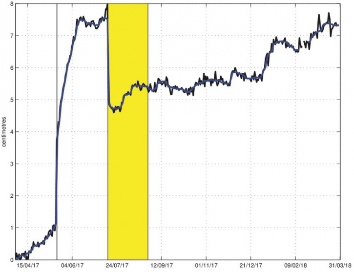
Figure 2: Illustration of the deformation during the last twelve months (the injection of magma of May 17, 2017 is represented by a black bar and the eruption of July 14-August 28, 2017 is shown in yellow). Here is shown a baseline (distance between two GPS receivers) crossing the Dolomieu crater from north to south (in black the raw data, in blue the data smoothed over a week). A rise is synonymous with elongation and therefore swelling of the volcano; conversely, a decrease is synonymous with contraction and therefore deflation of the volcano. (© OVPF / IPGP)
Geochemistry of gases
– Geochemical composition of the summit fumaroles:
A change of composition was detected in the summit fumaroles on March 23, 2018 (presence of fluids enriched in CO2 and SO2). Since the concentrations of SO2, H2S and CO2 in excess on the atmosphere remained low and close to the limit of detection.
– CO2 concentration in the soil:
Following the sharp increase in CO2 concentrations in the Volcano Cottage area in February, these concentrations dropped in March. This drop in CO2 concentration, associated with a building inflation and an increase in seismicity, shows a possible transfer of magma to lower depths (superficial reservoir).
Balance sheet
All of these observations show for the month of March:
a magma replenishment of the superficial magmatic reservoir which is maintained;
– a pressurization of the superficial magmatic reservoir which has a tendency to accelerate notably on the last week of March with two main peaks of seismicity on March 28th and 31st.
Source : OVPF.
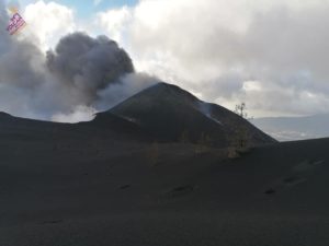
Etna , Sicily :
Communication by Boris Behncke.
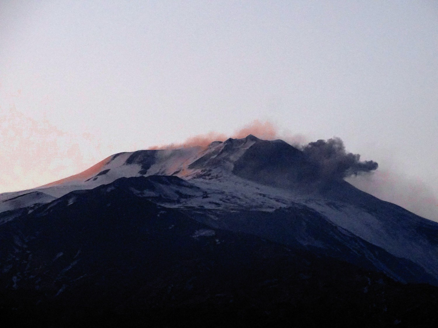
One of the rare and low ash emissions of the « U Puttusiddu » of the new crater of the Southeast, photographed in the last lights of the sunset of April 1, 2018 from Tremestieri Etneo. It has been a few days since these emissions resumed after a few weeks of total calm. Nothing new, no hot material, Etna has still not decided what to do, when, where and how.
Source : Boris Behncke Facebook