March 15 , 2018.
Shinmoedake , Japan :
31,934 ° N, 130,862 ° E
Elevation : 1700 m
Danger ebbs at Kyushu volcano, but eruption not over, say experts .
14 MARCH 2018. The eruption of Kyushu’s Mount Shinmoedake is expected to carry on for the time being, but no more lava flow is expected, volcano experts said. Smoke and fumes rose to 2,800 meters by 3 p.m. on March 13, the highest point for 24 hours.
The Coordinating Committee for Prediction of Volcanic Eruption of the Japan Meteorological Agency predicted that the two-week long eruption would continue, but that the flowing molten lava seen on March 9 would not return.
The accumulated magma has come out already, and pyroclastic flows will not likely occur. Even if they do occur, it is unlikely that the flows would reach the residential area beyond the warning restriction area,” said Kazuhiro Ishihara, chairman of the committee.
The eruption began on March 1 and reached an explosive phase on March 9 with large rocks reaching about 2 kilometers from the crater as the pressure of volcanic gas increased. The amount of lava flowing from the crater was an estimated 14 million cubic meters.
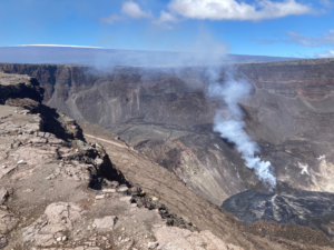
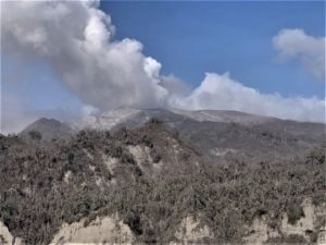
According to news articles, ash plumes from Shinmoedake (Shinmoe peak), a stratovolcano of the Kirishimayama volcano group, caused the cancelation of about 80 flights in and out of Kagoshima airport on 6 March. JMA reported that daily explosions during 6-13 March generated ash plumes that generally rose 3 km above the crater rim, though an ash plume on 10 March rose as high as 4.5 km. Explosions also ejected tephra that fell 700-1,800 m from the vent. Ashfall was reported in a wide area including in the prefectures of Nagasaki, Kumamoto, Miyazaki, and Kagoshima. An explosion at 1558 on 9 March rattled structures in the Kagoshima and Miyazaki prefectures.
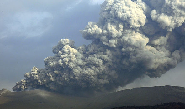
Satellite images showed an increase in the crater diameter from 550 m on 7 March to 650 m on 9 March. During overflights on 9 March observers noted white plumes rising from the margins of the lava covering the crater floor, from lava flows on the S flank, and from newly forming lava flows on the NW flank. The volume of erupted lava was an estimated 14 million cubic meters. The NW lava flow had advanced 226 m by 13 March. A high number of volcanic earthquakes continued to be recorded, in addition to many low-frequency earthquakes with shallow hypocenters. Volcanic tremor was continuous from 1 March until 1536 on 8 March; afterwards the signals had small amplitudes and were intermittent. The Alert Level remained at 3 (on a scale of 1-5).
Source : The Asahi Shimbun , GVP.
Photos : Via Theresa Munoz , Express co.uk.
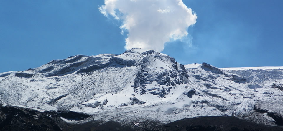
Nevado Del Ruiz , Colombia :
Subject: Bulletin of activity of the Nevado del Ruiz volcano.
The level of activity continues at the level: Yellow activity level or (III): changes in the behavior of volcanic activity.
With regard to monitoring the activity of the Nevado del Ruiz volcano, the COLOMBIAN GEOLOGICAL SERVICE informs that:
During the last week, the Nevado del Ruiz volcano recorded values similar to those of the previous week, both in the seismic activity associated with rock fracturing in the volcanic building and in the dynamics of the fluids at the interior of volcanic canals.
The seismicity caused by the fracturing of the rocks that make up the volcano was mainly in the north-eastern sector of the volcanic structure and, to a lesser extent, in the Arenas crater, at depths between 1.3 and 5.6 km. . The maximum magnitude recorded during the week was 0.7 ML (Local Magnitude), corresponding to the earthquake recorded on March 8 at 18:30 (local time), located in the Arenas crater, at a depth of 2.0 km.
Seismicity related to fluid dynamics in volcanic canals was characterized mainly by the occurrence of multiple fluid earthquakes, long-period events, and tremor impulses. The earthquakes were mainly located in the crater of Arenas and its surroundings. The recording of seismic signals of this type, of higher energy that can be associated with emissions of gas and ash, is not excluded.
Volcanic deformation measured from electronic inclinometers, Global Navigation Satellite System (GNSS) stations and radar images shows stability behavior without recording significant deformation processes of the volcanic structure.
The volcano continues to emit water vapor and gases into the atmosphere, including sulfur dioxide (SO2), as evidenced by the values obtained by the SCANDOAS stations installed in the volcano area. satellite image analysis. In monitoring the information provided by the MIROVA and NASA FIRMS portals, several thermal anomalies have been reported near the Arenas crater.
The column of gas and steam reached a maximum height of 500 m measured on the summit of the volcano on March 6. The direction of column dispersion was governed by the direction of the wind in the area, which had a predominant direction to the northwest, from the Arenas crater.
The Nevado del Ruiz volcano continues at the level of yellow activity.
Source : Ingeominas
Photos : M. Arias , Ingeominas.
Kadovar , Papua New Guinea :
3.608°S, 144.588°E
Elevation 365 m
RVO reported that emissions from Kadovar’s Main Crater were white from 1 March, until an explosion on 1800 on 5 March was followed by gray emissions through 8 March. The gray plumes rose less than 360 m above the vent and drifted SE.
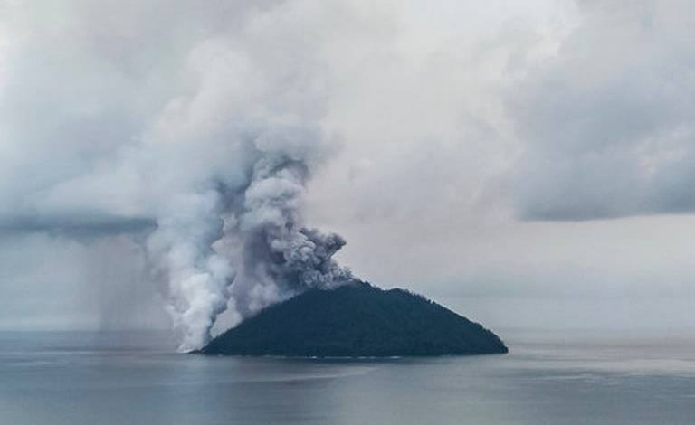
Noises were described as roaring and rumbling during 1-2 and 6-8 March, and booming on 5 March. The lava dome at the SE Coastal Vent continued to grow and rose to 7-8 m above sea level on 1 March, 10-11 m on 2 March, and 10-17 m on 8 March. Dark gray ash plumes rose from the dome. Nighttime incandescence was noted from both Main Crater and the SE vent.
Source: Observatoire du volcan Rabaul (RVO), GVP.
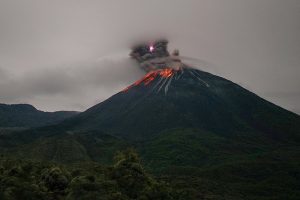
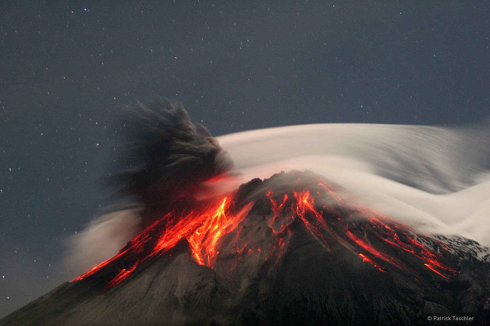
Reventador , Ecuador :
0.077°S, 77.656°W
Elevation 3562 m
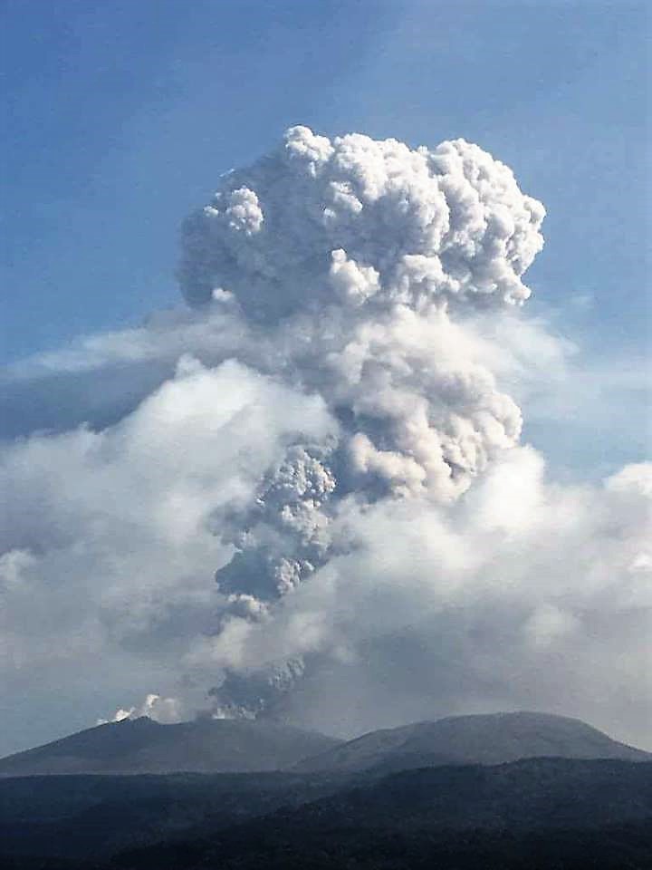
During 6-13 March , IG reported a high level of seismic activity including explosions, long-period earthquakes, harmonic tremor, and signals indicating emissions at Reventador. Steam, gas, and ash plumes sometimes rose higher than 600 m above the crater rim and drifted N, NW, and W. Incandescent blocks rolled as far as 800 m down the flanks. On 13 March a pyroclastic flow traveled 400 m down the S flank. Weather clouds sometimes prevented visual observations.
Institute of Geophysics of Information – EPN
Activity level of the surface: High. Surface trend: No change
Activity Level Internal: High. Internal trend: No change
Seismicity (Events): From (Date & Time): 2018-03-13 11:00 to (Date & Time): 2018-03-14 11:00
Total events: Long Period type (LP): 30. Explosions (EXP): 36. Tremor of Emission (TE): 3. Tremor Harmonic (TA): 10
Rain / lahars: No rain was recorded.
Emission / Ash column: At the end of yesterday afternoon, an ash emission of a height greater than 600 meters to the west was observed.
Other monitoring parameters: No change.
Observations: During the night and early morning, an incandescence was observed at the top with the descent of blocks from all sides of the volcano to 600 meters below the crater level.
Alert level: Orange
Source: Instituto Geofísico-Escuela Politécnica Nacional (IG), IGEPN.
Photo : Patrick Taschler