March 14 , 2018.
Shinmoedake , Japan :
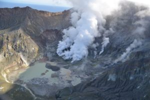
Mount Shinmoe’s explosive eruptions likely to continue for several months, experts say
Kyodo,Mar 13, 2018
Mount Shinmoe in southwestern Japan is expected to continue explosive eruptions for several months or more, the Meteorological Agency’s eruption prediction committee said Tuesday.
As violent eruptions of the 1,421-meter-high volcano straddling Kagoshima and Miyazaki prefectures have been observed for a week, the agency has maintained an alert level which restricts people from approaching the volcano.
It also warned of the risk of large flying rocks in an area within 4 km of the crater and pyroclastic flows within 2 km of the crater.
According to the Coordinating Committee for Prediction of Volcanic Eruptions, people in the area still need to be on alert for flying rocks and volcanic infrasound due to eruptions for the time being, but the possibility of pyroclastic flows reaching the foot of the mountain and residential areas is low.
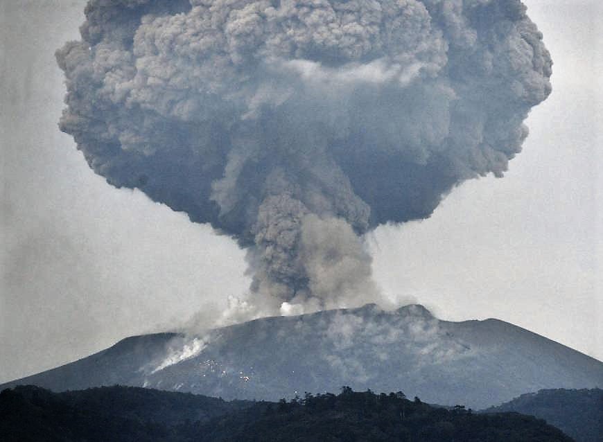
While the Kirishima mountain range encompassing Mount Shinmoe had appeared to be swelling since last July with the possibility of the magma chambers refilling underneath, there were movements of contraction from March 6 to 8 as it released lava. The amount of lava pooled in the crater appears to have been unchanged since around Saturday.
“At least about 60 to 70 percent of the magma deposit underneath is believed to have been released,” said Kazuhiro Ishihara, professor emeritus at Kyoto University and head of the prediction committee, adding it is necessary to keep monitoring the volcano.
Source : Japantimes
Cerro Machin , Colombia :
Subject: Cerro Machín Volcano Activity Bulletin.
The level of activity continues at the level: Yellow activity level or (III): changes in the behavior of volcanic activity.
Regarding the monitoring of the activity of the Cerro Machin volcano, the Colombian Geological Survey reports that:
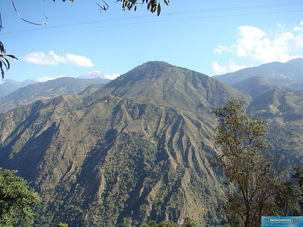
During the last week, the Cerro Machin volcano recorded a low energy seismic activity associated with the fracturing of the rocks that make up the volcano. This seismic activity was located in the main dome, south and southeast of it, at depths between 2.7 and 12 km. The maximum magnitude recorded during the week was 0.8 ML (Local Magnitude) for the March 12 earthquake at 09:22 (local time), located southeast of the main dome, 4.9 km from depth. The other monitored parameters did not show any significant changes.
The Colombian Geological Survey continues to monitor the evolution of the volcanic phenomenon and will continue to report in a timely manner on any changes that may occur.
Source : Ingeominas.
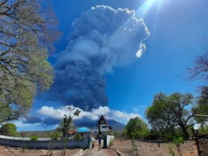
Mayon , Philippines :
MAYON VOLCANO BULLETIN 14 March 2018 08:00 A.M.
Mayon’s activity in the past 24 hours was characterized by general quiescence, weak degassing from the summit crater and gravity-driven lava flow. Weak emission of bluish steam-laden plumes that rose to 700 meters before drifting southwest occurred intermittently throughout the day. Lava flows could be observed at night to be moving downslope on the Miisi,Bonga and Basud Gullies within 3.3 kilometers, 4.5 kilometers and 1.9 kilometers of the crater, respectively.
A total of twenty three (23) volcanic earthquakes and twenty five (25) rockfall events were recorded by Mayon’s seismic monitoring network. Sulfur dioxide (SO2) emission was measured at an average of 458 tonnes/day on 13 March 2018. A Slight inflation of the lower flanks beginning 11 March 2018 was recorded by electronic tilt, consistent with results of Precise Leveling (PL) surveys on 03 – 06 March 2018. Overall ground deformation data indicate that the edifice is still swollen or inflated relative to pre-eruption baselines.

Alert Level 3 currently prevails over Mayon Volcano. This means that although Mayon’s unrest continues, there is a decreased likelihood of hazardous explosive eruption to occur. PHIVOLCS-DOST reminds the public of sudden explosions, lava collapses, pyroclastic density currents or PDCs and ashfall can still occur and threaten areas in the upper to middle slopes of Mayon. PHIVOLCS-DOST recommends that entry into the six kilometer-radius Permanent Danger Zone or PDZ and a precautionary seven kilometer-radius Extended Danger Zone or EDZ in the south-southwest to east-northeast sector, stretching from Anoling, Camalig to Sta. Misericordia, Sto. Domingo, must be strictly prohibited. People residing close to these danger areas are also advised to observe precautions associated with rockfalls, PDCs and ashfall. Active river channels and those perennially identified as lahar prone areas in the southern and eastern sectors should also be avoided especially during bad weather conditions or when there is heavy and prolonged rainfall. Civil aviation authorities must advise pilots to avoid flying close to the volcano’s summit as airborne ash and ballistic fragments from sudden explosions and PDCs may pose hazards to aircrafts.
PHIVOLCS-DOST is closely monitoring Mayon Volcano’s activity and any new significant development will be immediately communicated to all stakeholders.
Source : Phivolcs
Ibu , Indonesia :
Level II Activity Level (WASPADA). G. Ibu (1340 m above sea level) has been erupting since 2008.
Since yesterday until this morning visually the peak of the volcano was clearly visible until it was covered with fog. The tall gray eruption columns are medium to low to moderate pressures rising 300 to 600 m above the summit. The column of ash is inclined towards the South and the West.

According to the seismograph, dated March 13, 2018, it was recorded:
127 earthquakes of eruption.
116 earthquakes emission.
41 harmonic tremor earthquakes.
Recommendations:
Communities around G. Ibu and visitors / tourists should not have activity, climb and approach within 2 km, with a sectoral expansion of 3.5 km towards the opening in the northern part of active crater of G. Ibu.
VONA:
The last VONA code sent was the color code ORANGE, published on August 28, 2017 at 06:12 WIT, for a related eruption with ash emissions at 1725 m above sea level or 400 m above the peak ash column inclined to the north.
Source : VSI
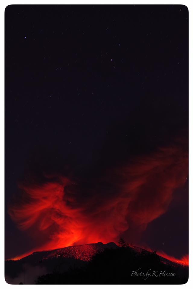
Villarica , Chile :
VOLCAN VILLARRICA – March 10/13, 2018
March 10: The processed satellite images show a tempered chimney about 40 meters in diameter and a lava pit about 13 x 7 m in diameter.
March 13: A sporadic incandescence was captured with a 500 mm objective of Pucón, about 16 km away from the crater. On 25 and 26 February and 5 and 6 March, the incandescence was also recorded, but of lesser intensity.
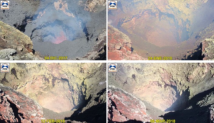
THE LAVA WELL HAS BEEN DEEPENED IN THE PAST THREE MONTHS
During the first half of December 2017, the lava pit descended tens of meters, maintaining its deep level until now, as illustrated by the sequential images captured from the edges of the crater.
Source : Povi / Werner Keller.