April 28 , 2025.
Alaska , Spurr :
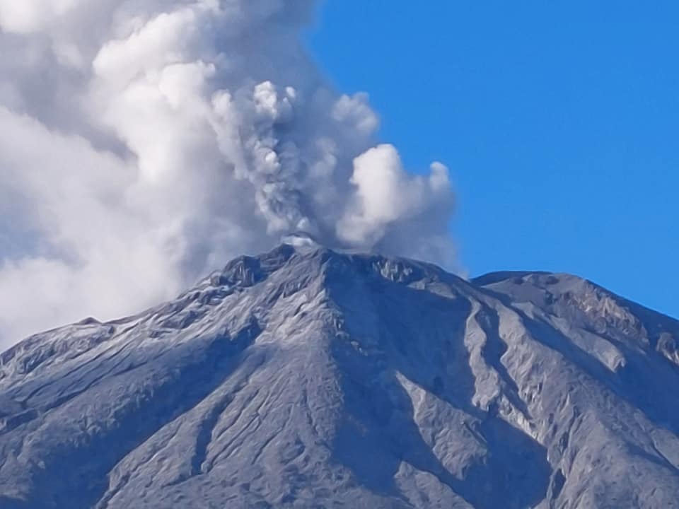
Unrest continues at Mount Spurr volcano. Frequent small volcanic earthquakes were detected beneath the volcano over the past day. Most of the earthquakes that are occurring under the volcano are too small to be located. Nothing unusual was observed in mostly cloudy webcam and satellite views.
Results from the overflight on April 24 show that gas emissions are broadly unchanged from March, and remain elevated above background levels.
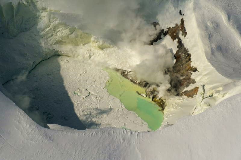
View of the Mount Spurr summit crater lake on an April 25 overflight and gas survey. The water is greenish blue to yellow, due to suspected sulfur precipitates in the water. Floating ice covers the southern half of the lake. The fumarole field on the north shoreline is visibly steaming.
Although unrest continues, there have been no changes observed in the monitoring data to indicate that the volcano is moving closer to an eruption. Based on previous eruptions, changes from current activity in the earthquakes, ground deformation, summit lake conditions, and fumarolic activity would be expected if magma began to move closer to the surface. Therefore, if an eruption occurred, it would be preceded by additional signals allowing warning.
The volcano is monitored using local seismic, infrasound, web camera, and GNSS (GPS) stations along with regional infrasound, lightning networks and satellite data
Source : AVO
Photo : Loewen, Matt / Alaska Volcano Observatory / U.S. Geological Survey.
Philippines , Bulusan :
Notice for raising the alert status of Bulusan Volcano from Alert Level 0 (Normal) to Alert Level 1 (Low-level Unrest).
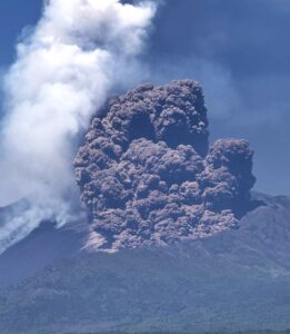
A phreatic eruption occurred from the summit crater of Bulusan Volcano at 04:36 AM today, 28 April 2025, and lasted 24 minutes based on seismic and infrasound records. The event produced a bent plume that rose 4,500 meters above the crater before drifting west to southwest. Ashfall was reported in Brgys. Cogon and Bolos, Irosin, Brgys. Puting Sapa, Guruyan, and Buraburan, Juban, and Brgy. Tulatula Sur, Magallanes, Sorsogon Province. A pyroclastic density current (PDC) or “uson” descended the southwestern slopes and travelled within three (3) kilometers from the summit vent. Prior to the eruption, a total of fifty-three (53) volcanic earthquakes were recorded over the 24-hour period yesterday. Rumbling sounds were reported by local government officials approximately 15 minutes before the eruption and were recorded by infrasound sensors.
In view of the above, DOST-PHIVOLCS is now raising the alert status of Bulusan from Alert Level 0 to Alert Level 1, which means that the volcano is currently in a state of low-level unrest with chances of phreatic eruptions succeeding this morning’s event. Local government units and the public are reminded that entry into the 4-kilometer radius Permanent Danger Zone (PDZ) must be strictly prohibited and that vigilance in the 2-kilometer Extended Danger Zone (EDZ) on the southeast sector must be exercised due to the possible impacts of volcanic hazards such as PDCs, ballistic projectiles, rockfall, avalanches and ashfall on these danger areas. Communities that experience ashfall must take all necessary precautions and use protective masks or wet cloth to prevent ash inhalation. Civil aviation authorities must also advise pilots to avoid flying close to the volcano’s summit as ash from any sudden phreatic eruption can be hazardous to aircraft. Furthermore, people living within valleys and along river/stream channels especially on the southeast, southwest and northwest sector of the edifice should be vigilant against sediment-laden stream flows and lahars in the event of heavy and prolonged rainfall should phreatic eruption occur.
DOST-PHIVOLCS is closely monitoring Bulusan Volcano’s condition and any new development will be relayed to all concerned.
Source : DOST-PHIVOLCS
Photo : Sorsogon news. ( 2022) .
Indonesia , Lewotobi Laki-laki :
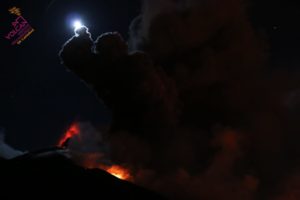
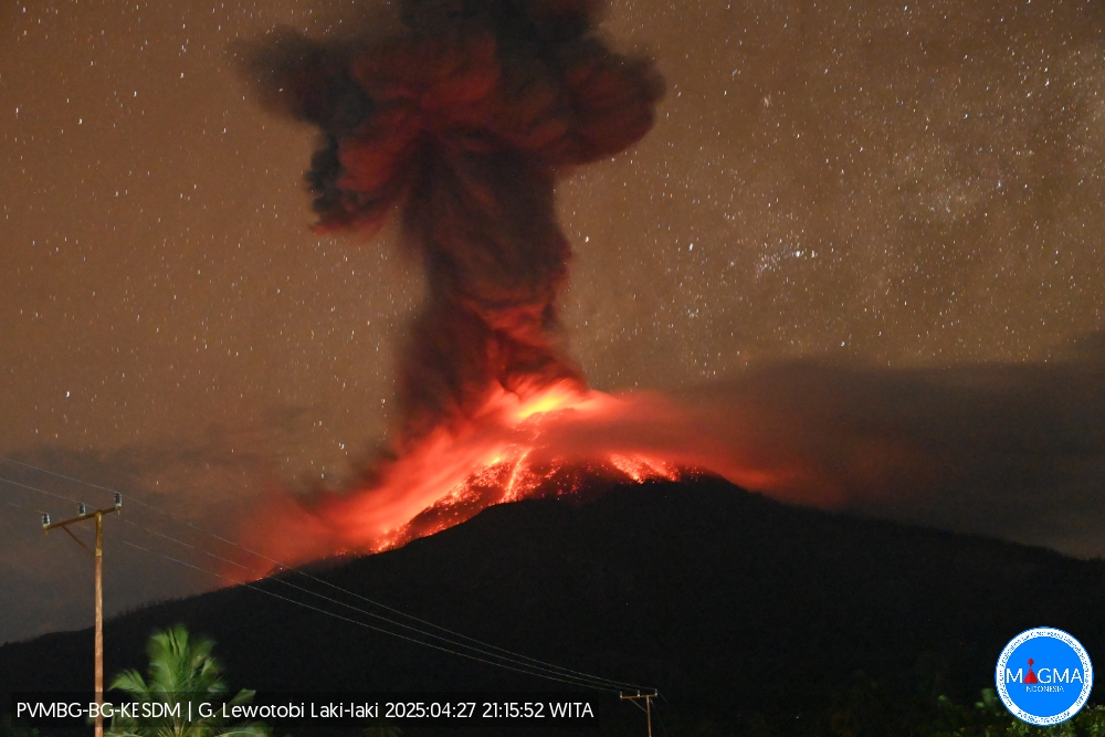
An eruption of Mount Lewotobi Laki-laki occurred on Sunday, April 27, 2025, at 9:15 PM WITA. The observed ash column was ± 4,000 m above the summit (± 5,584 m above sea level). The ash column was gray and intense in intensity, oriented toward the north and northeast. This eruption was recorded by seismograph with a maximum amplitude of 47.3 mm and a duration of 64 seconds.
VOLCANO OBSERVATORY NOTICE FOR AVIATION – VONA
Issued : April 27 , 2025
Volcano : Lewotobi Laki-laki (264180)
Current Aviation Colour Code : ORANGE
Previous Aviation Colour Code : orange
Source : Lewotobi Laki-laki Volcano Observatory
Notice Number : 2025LWK304
Volcano Location : S 08 deg 32 min 20 sec E 122 deg 46 min 06 sec
Area : East Nusa Tenggara, Indonesia
Summit Elevation : 5069 FT (1584 M)
Volcanic Activity Summary :
Eruption with volcanic ash cloud at 13h15 UTC (21h15 local).
Volcanic Cloud Height :
Best estimate of ash-cloud top is around 17869 FT (5584 M) above sea level or 12800 FT (4000 M) above summit. May be higher than what can be observed clearly. Source of height data: ground observer.
Other Volcanic Cloud Information :
Ash cloud moving from north to northeast. Volcanic ash is observed to be gray. The intensity of volcanic ash is observed to be thick.
Remarks :
Eruption recorded on seismogram with maximum amplitude 47.3 mm and maximum duration 64 second.
Source et photo : Magma Indonésie .
Ecuador , Sangay :
SANGAY VOLCANO DAILY STATUS REPORT, Sunday, April 27, 2025.
Information Geophysical Institute – EPN.
Surface Activity Level: High, Surface Trend: Ascending
Internal Activity Level: Moderate, Internal Trend: Ascending
Seismicity: From April 26, 2025, 11:00 a.m. to April 27, 2025, 11:00 a.m.:
Seismicity:
Below is the count of seismic events recorded at the reference station.
Explosion (EXP): 239
Precipitation/Lahars:
Since yesterday afternoon, no rain has been recorded in the volcano area. **Heavy rains could remobilize accumulated material, generating mud and debris flows that would cascade down the volcano’s flanks and flow into adjacent rivers**.
Emission/Ash Plume:
Due to weather conditions, no gas or ash emissions could be observed via the surveillance camera network or the GOES-19 satellite system. Furthermore, the Washington-based VAAC has not published an activity report for this volcano.
Observation:
Due to cloud cover in the area, only one episode of incandescent material could be observed via the surveillance camera network, 200 meters below the crater level. As of the closing date of this report, the volcano remains entirely cloudy.
Alert Level: Yellow
Source : IGEPN
Photo : Volcan Sangay / FB.
Costa Rica , Poas :
OVSICORI-UNA Statement on Poás Volcano, Updated April 25, 2025.
Summary:
OVSICORI-UNA is observing continuous eruptive activity, with variability in monitoring parameters:
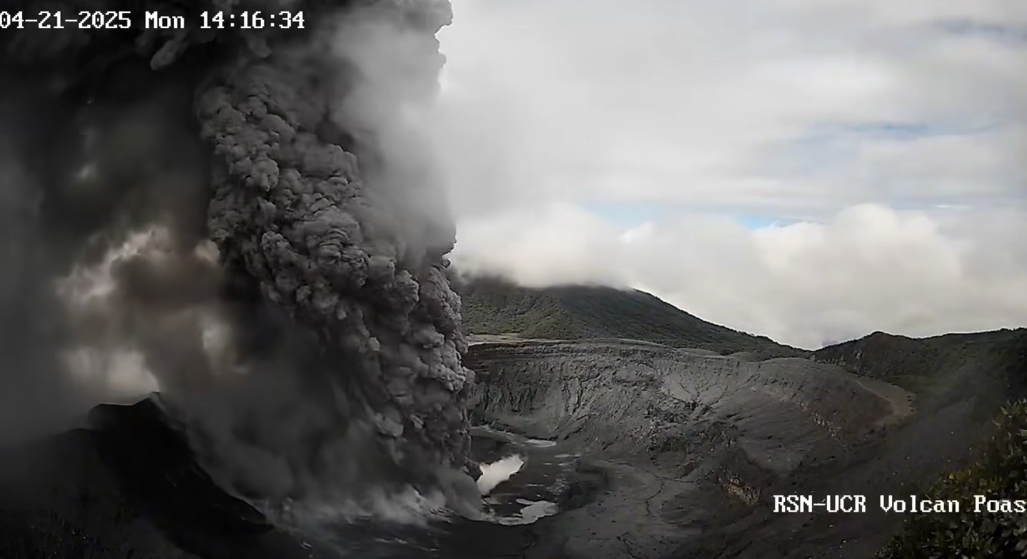
● Two major eruptions measuring more than 4 km above the crater level, representing the highest values since 2017.
● The eruptions are phreatomagmatic in nature.
● Ash emission is almost continuous, dispersing mainly towards the western quadrant and sporadically towards the south-southwest.
● A change in seismic patterns, marked mainly by a decrease in tremor.
● No significant deformation has been recorded in recent days.
● A high level of degassing. ● An increase in the content of juvenile material is observed.
The OVSICORI-UNA (National Volcanic Observatory) raised the volcanic alert level to 3 (WARNING) on March 7, 2025, following an increase in monitored geophysical and geochemical parameters (seismic, crustal deformation, gas and ash composition).
Since Sunday, March 23, a new phase of this eruptive cycle has been observed, characterized by almost continuous phreatomagmatic eruptions of moderate energy.
A high probability of eruptions persists, which could impact areas of Poás Volcano National Park visited by tourists (falls of « bombs » or rocks, ash, gas, aerosols), as well as the populations surrounding the Poás Volcano (ash, gas, aerosols) in the coming days and weeks. The volcano’s activity level is 3 out of 4 (WARNING).
Eruptive Activity
The eruptive phase, which began on March 23, is ongoing at the time of writing. Although eruptive activity is nearly continuous, the energy and explosiveness of the eruptions vary, ranging from continuous ash emissions to explosions of varying magnitude. From the beginning of this phase until April 13, larger pulses were recorded in Boca C (North), with a frequency of approximately one or more events per day. However, from April 13, activity decreased, mainly due to the absence of these larger pulses. Concurrently, increased activity was observed in Boca A (South), mainly in the form of nocturnal incandescence (due to sulfur combustion) and higher ash content in the plume. On April 20, a small pulse was observed in Boca A, exceeding background activity (< 150 m). The next day, April 21, at 2:14 PM, a larger eruption occurred, measuring over 4 km in height and lasting over 5 minutes. Another very similar eruption occurred on April 23 at 5:29 AM.
Source : Ovsicori.
Photo : RSN-UCR.